| Application - New | |
Can LADM contribute to a more fair large scale land acquisition?
The paper investigates up to which level the Land Administration Domain Model (LADM) can contribute to a fair approach in large scale land acquisition |
 |
|
 |
|
 |
|
 |
|
Potential conflicts between customary and / or informal systems of land tenure with the state supported formal systems of land registration are an issue in many developing regions. Africa presents a significant challenge because the traditional authorities (chiefs, clans, families etc.) have significant authority over land in most countries. Where it exists, formal land administration consists of the conventional approach based predominantly on deeds and title registration. However, the vast majority of the urban and rural population in African countries uses customary systems of land administration. Further due to the complex nature of the cadastre and property rights, colonial land administration laws and regulations remain entrenched in many countries (Burns, 2006; UN ECA, 2012).
In recent years, a new dimension has added to this situation and makes it more complex. Non-African governments concerned about stability of food supplies are promoting acquisition of farmland in foreign countries as an alternative to purchasing food from international markets. This fastevolving context creates opportunities, challenges and risks. Increased investment may bring macro-level benefits and create opportunities for raising local living standards (Cotula et. al., 2009; Von Braun, and Meinzen-Dick, 2009).
On the other hand, land deals in Africa are framed by high levels of public concern over land rights and food security, both within countries and internationally. Commentators and insiders recognise the need to weigh the ambitions and potential of large-scale land-based developments against the concerns of host country citizens about sovereignty over local resources, as well as the vigorous criticism of some civil society organisations (Cotula et. al., 2009). This study is largely based on previous studies done by international organisations and many of them refer to media reports as their basis. For this study, the authors have tried to present the situation in the context of the Land Administration Domain Model (LADM) framework.
The continuum of land rights
Already in the FIG Bogor Declaration (FIG, 1996) the different needs from different countries are underlined: a simple low cost manual cadastre recording only private ownership rights may be appropriate for one country, while a sophisticated and relatively expensive fully computerised cadastre recording a wide range of ownership and land use rights may be appropriate for another country. The infrastructure can support a vast array of legal, technical, administrative and institutional options in designing and establishing an appropriate cadastral system, providing a continuum of forms of cadastre ranging from the very simple to the very sophisticated. Such flexibility allows cadastres to record a continuum of land tenure arrangements (Section 4.5 of the Bogor Declaration) from private and individual land rights through to communal land rights, as well as having the ability to accommodate traditional or customary land rights. In field operations there is a range of technologies from plane table to GPS. Work may commence with large scale images for adjudication purposes.
Larsson (1991) presents ‘axis of variation’ in the (so-called progressive, see Fourie and Van Gysen (1995)) development of cadastral/land information systems. One can start at different levels; types of simplification can be seen as variations along a number of axes – which together determine information content. Most important axes are according to Larsson:
– the land – unit division axis. For parcel based systems a division in land units is imperative. Variations can be found in size of the units – group (village), farm, parcel, etc,
– the location – determination axis. Location of land can be indexed without maps, as in the Doomsday Book and in most ancient tax recordation’s. It can be also located by a point on an aerial photograph or map or as a co-ordinate. If the boundaries of the units have been recorded on the ground, they can be recorded in a map or co-ordinate record with a varying degree of accuracy. This depends partly on whether ground survey, photo interpretation or photogrammetric methods are being used. Variations in methods and results are possible,
– the information – content axis. To the primary land unit designation can be added various information. Such as area, land use, buildings, assessed value, owner, other rights, population, etc,
– the information – quality axis. In a land information system may vary considerably in quality,
– the maintenance – axis. Larsson says that the availability of up-todate data is of strategic importance for land information systems. It may be included as a quality issue, and:
– the spatial – axis. This is about priority setting in order to determine which areas should be included.
Fourie (1998) pays a lot of attention to identification of objects. As a result a range of identifiers has been proposed based on some innovative new concepts, see also Fourie and Nino-Fluck (2000): points, lines, sketch maps, text, list of names, non geo-referenced parcels, unique numbers, geo-referenced parcels, etc.:
– points, geo-codes (sometimes known as dots on plots), and lines, in vector or raster format;
– polygons with fuzzy boundaries;
– text, including lists of names and unique numbers;
– parcels – poorly surveyed, non georeferenced and geo-referenced; and:
– sketch maps, and photographs, in the absence of any better description.
In 1998 Fourie undertook a comprehensive review of the cadastre and land information in Africa for the United Nations Economic Commission for Africa. An overview is presented in that review as to what is required in terms of spatial units, identifiers, representation of varying accuracies, scales and qualities combined with persons and based on evidence (from the field) of how social tenures actually worked. The whole spectrum of tenure systems needs to be covered: formal, informal and customary systems, not neglecting land related disputes and conflicts. Focus in the design of systems should be on sustainable development – not on land transactions and mortgage. Design criteria for an information system are worked out in detail in this review – e.g. on the use of graphical reference frameworks; on the possible use of a range of instruments and data acquisition methods; on the contents of an information system where cadastre can be a linked system.
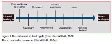
The importance of standards and national spatial frameworks was recognised, allowing decentral use of data for different purposes and for many different decision makers, combined with central use of data. Conventional LASs are parcel based. Fourie and Nino-Fluck (1999) propose ranges of technologies for data acquisition. Modelling: cadastral mapping using remotely sensed images, aerial photographs and GPS as source should be possible. According to them it should be possible to have flexible accuracy demands: it should accommodate, ‘defined in Dale and McLaughlin (1988) terms’, graphical (pictorial) data, geometric (measurement based) data and topological data. Illegal and informal lands and customary lands should be possible to include. A continuum of land rights is proposed in UN-HABITAT (2008).
LASs are not yet supporting all these requirements. This continuum of land rights was already discussed in UNHABITAT, 2003: ‘there is a range of land rights in most countries which occupy a continuum, with a number of such rights occurring on the same site or plot’. And: ‘there is a range of informal-formal (illegal-legal) types along a continuum, with some settlements being more illegal in comparison to others’. There is a reference to Payne (1997) who speaks about a useful strategy for policy makers ‘…every step along the continuum from complete illegality to formal tenure and property rights as a move in the right direction, to be made on an incremental basis’.
Simple approaches to formalise land market transactions (announcement of agreements at public meetings, providing facilities for written transactions, registration of contracts, and the witnessing of signatures. And: low cost survey and registration procedures. Further attention is paid to the recognition and integration of customary rights into the legislative framework and the extension of tenants rights.
UN-HABITAT (2008) views the various types of land right as existing along a continuum, with some settlements being more consistent with law than others. This view makes it possible to include the people with the weakest tenures in the idea of sufficient legal access, see Figure 1.
One more ‘continuum’ is at the subject side: FIG (1995) states that land units as parcels are defined by the formal or informal boundaries marking the extent of lands held for exclusive use by individuals and specific groups of individuals (e.g. families, corporations, and communal groups). Toulmin and Quan, 2000, speak about land shared by several groupings (e.g. wetlands, woodlands, grazing area’s) and about fuzzy boundaries.
Today there is more and more discussion about complete global coverage, see for example (Bennet et al, 2010). There can be support in the avoidance of land grabbing with an overview of the complete set of existing people to land relationships. Knowledge on areas which are included in land registry and area’s which are not included has a special value in this context.
Enemark (2012) recognises cadastre as the core engine for spatially enabled land administration. According to him spatial enablement is not primarily about accuracy: it is about adequate identification, completeness and credibility. Systems should be built using a ‘fit for purpose’ approach while accuracy can be incrementally improved over time when justifying serving the needs of citizens and society. In relation to the concept of the continuum of land rights such a fit for purpose approach could then be referred to as a ‘continuum of accuracy’.
In (Zevenbergen, 2013) the development of pro-poor land-recording systems is highlighted. It is stated that the Global Land Tool Network (GLTN) will document and analyse the institutional issues associated with local land-record management, before undertaking a pilot project. Work is also needed on organising data collection for local land records, such as customary land rights. It is important to find ways for the public sector – especially the courts and land agencies – to accept information from these nonconventional approaches, for example, to accept them as evidence in a court case, or to use them for land management. A next step would be to set up land information systems that cover larger areas and that rely on information from both conventional and non-conventional sources.
CheeHai Teo, (2012) sees a ‘continuum of approaches’, ranging from ‘less rigorous’ to more ‘rigorous’, a ‘continuum of technology’, ranging from ‘less sophisticate’ to ‘more sophisticate’ and a ‘continuum of measurement’ from ‘more precise’ to ‘less precise’.
The Social Tenure Domain Model (STDM) (Augustinus et.al, 2006, FIG, 2010, UN HABITAT 2012), as a specialisation of the Land Administration Domain Model, brings all required functionality together. This functionality is also available in the LADM (ISO, 2012). LADM includes the so called Basic Adminsitrative Units, allowing grouping of spatial units. This functionality is not explicitly (but implicitly) available in STDM.
Transfers on land (use) rights and restrictions
Foreign governments and private enterprises are described as involved in dealings with national or sub-national governments and also with community representatives or individuals; see for example (Oxfam, 2011). However, different reports mentioned dominance of different parties in such types of dealings. Generally a private or joint equity company is engaged in acquiring land, but it can also be a foreign government. On the other side of the deal is a land provider, either a government or, much more rarely, a private land-owner (Cotula et al, 2009; Friis and Reenberg, 2010).
Each deal typically involves a wide range of parties through the multiple stages of preparing, negotiating, contracting and operationalising the project. First, multiple agencies within the host government are engaged. Even in countries where there is a central point of contact (‘one-stop shop’) for prospective investors, usually an investment promotion agency, this agency alone will not deal with all aspects of the land deal. At a minimum, the investor is likely to need to engage separately with government agencies at the local level. As per World Bank Study (Deininger et. al., 2011), contrary to the image of a neo-colonial foreign scramble for land that often emerges from media reports, acquisitions recorded by official inventories are dominated by local individuals or companies.
Specific restrictions on the acquisition of certain land rights by non-nationals may also exist. In some countries, non-nationals face restrictions on land ownership (e.g. in Ghana, under article 266 of the 1992 Constitution) and on resource use (for example, in Tanzania foreigners may acquire land rights only for the purpose of an investment project under the Tanzania Investment Act). But under certain circumstances incorporation of local subsidiaries may enable foreign investors to overcome these barriers. And in countries like Mali there is no formal legal differentiation of treatment between nationals and nonnationals though differences in practice may still exist. In Mozambique, foreign and domestic investors alike may acquire a renewable 50-year land use right, which for the first two years (five for nationals) is conditional upon the implementation of an agreed investment plan (articles 17 and 18 of the Land Act 1997).
In terms of legal analysis, the Sudan-Syria inter-governmental land deal, involves a renewable 50-year lease; the government of Sudan commits itself to delimiting the land and delivering it to the government of Syria “free from any right” other than ownership, which remains vested with the government of Sudan (article 3 of the agreement). The contract between Varun and 13 associations of local landowners involves a 50-year deal combining lease and contract farming arrangements, renewable for up to 99 years. Similarly, in Ethiopia, a contract from Benishangul Gumuz Regional State involved a 50-year lease (article 3). In Mali, land allocations to investors in the Office du Niger area also typically involve leases. Some African countries have recently taken steps to strengthen the protection of local land rights, including customary rights – even where land is state owned or vested with the state in trust for the nation. Customary rights are for instance protected, to varying degrees, under Mali’s Land Code 2000, Mozambique’s Land Act 1997, Tanzania’s Land Act and Village Land Act 1999 and Uganda’s Land Act 1998 (Cotula et al, 2009).
Unlike Latin America and Eastern Europe, the land deals taking place in Africa predominantly involve government allocated land leases or land-use rights being distributed instead of land sales. The types of land agreement are ultimately determined by the status of land ownership within countries, which in Africa often involves collective ownership. In fact, an estimate from the World Bank (Deininger et.al., 2011) states that between only 2 and 10 percent of land across Africa is held under formal land tenure, which is normally just in urban settings.
Most of the international studies have quoted the various media reports as their references. This is due to the lack of transparency in making public the documents related to many such deals. However at one point FAO (see Cotula, et. al., 2009) states that most documented land leases are granted by the government. This includes 100% of documented cases in Ethiopia, Mali and Mozambique, and the vast majority of cases in Sudan. In other countries there is room for private transactions, however. In Ghana, for example, leases may be granted by the Land Commission, by customary chiefs or by families or individuals, depending on who holds the land. All the land leases documented by the Ghana inventory were granted by private right holders, particularly customary chiefs purporting to act on behalf of their communities. World Bank report 2011 (Deiniger et. al., 2011) cites the data officially available to in-country consultants for large land transfers during 2004-09 in 14 countries, complemented by analysis of media reports on large investments in 2008-09.
LADM framework
The Land Administration Domain Model (LADM) has been published as a International Standard (IS) by the International Organisation for Standardization (ISO, 2012; Lemmen et al, 2011), as ISO 19152. The IS covers basic information related to components of land administration (including water and elements above and below the earth surface). It includes agreements on data about administrative and spatial units, land rights in a broad sense and source documents (e.g. deeds or survey plans). The IS can be extended and adapted to local situations; in this way all people land relationships may be represented (Lemmen et al, 2011). The different ‘continuum’ approaches, as introduced in section 2 of this paper are supported (ISO, 2012). See also (FIG, 2010) for the STDM. The core of LADM is in four basic classes: LA_ Party, LA_RRR, LA_BAUnit and LA_SpatialUnit. These are defined as follows:
Three typical forms of land tenure which can be abstracted from the reports from a number of countries in Africa (Burns, 2006; Cotula et.al, 2009; von Braun and Meinzen-Dick; 2009; Aryeetey and Lewis, 2010; Cuffaro and Hallam, 2011), coincide with the different forms of Property identified in the Rights Profile of ISO 19152 LADM proposal (ISO, 2012). Those three forms of tenure are: customary tenure, government land, and privately held land. Combined representations of those forms of tenure are presented below.
Customary tenure
One of these forms of tenure concerns the rights held in common by local communities, referred generally as customary tenure.
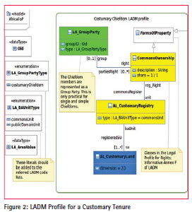
The diagram in Figure 2 depicts how this situation can be modelled by using LADM classes in UML, for the case of a single and simple Chiefdom (customary tenure), typically comprising a set of lands (as Spatial Units) around a village, governed by a single Chief. The group of members (Parties) holding property rights over the common land is represented by a Group Party (class LA_GroupParty in LADM) which collectively holds one or more (or none) Commons Ownership type of rights for a special type of Basic Administrative Unit (AL_CustomaryRegistry; check specialisations from LADM in Figure 7). It must be said that this kind of commonly held registries are not always registered in the existing Land Registry systems. So, a new kind of registry, or the integration into existing registry systems has to be considered to formalise such rights into each national property law.
Further, it is possible that each register for a Commons Ownership includes more than one, spatially separated Spatial Unit, including individual facilities or buildings included into private or state held property (the other two Forms of Property). A new type of Spatial Unit has been considered (AL_CustomaryLand as specialisation from LA_SpatialUnit).
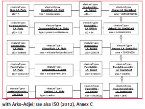
An example of a real case of customary tenure is presented in the instance level here below in Figure 3. See Arko- Adjei (2006) and Arko-Adjei (2011).
Government land
Another major form of property for many countries in Africa (namely Mozambique), are the government held lands through nationalisation, which can cover the entire jurisdiction or just a part of it, like in Ghana.
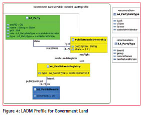
The class diagram in Figure 4 shows how LADM can model lands which fall into the Public Domain, and therefore are owned by the State. The owner, represented by the basic LADM class of LA_Party, with some default values for the role and type attributes, can be a single non natural person representing the whole state. But it is also possible to consider particular state or federal agencies which have the role of administering Public Domains of some sort. Each one of these agencies can have more than one ownership (and administration) rights.
This is represented by the PublicDomainOwnership class and the “stateOwns” association. Typically, it can be assumed that only one ownership right holds for a given basic administration unit, to be registered in a special public registry of lands. This is represented by the AL_ PublicLandRegistry class. These type of registers are usually separate from the classic Land Registries, namely in many Western European countries. For every registered Public Domain, there could be one or more individual Spatial Units, which must be considered apart from the customary and the private lands. And so, a specialised class (AL_PublicDomain) is considered. This should be represented by a Polygon with one or more holes, for any privately owned enclaves within the Public Domain. It should be allowed to constitute aggregates (as Multi-polygons), for the cases where the Public Domain Lands have non-contiguous parcels. The enumerations shown in the diagram correspond to code lists in LADM; however in this case, it was not needed to add any new literals to the existing ones.
Privately held Land
As can be abstracted by a number of references (Burns, 2006; Cotula, 2009; von Braun, 2009; Aryeetey, 2010; Cuffaro, 2011), there are few cases respecting land grabs, where the process is done primarily through private land acquisition. Involving thus the transfer of ownership from the previous owners (holding a freehold or property type of right), to the entity representing the foreign investors.
Rather, and as observed by (Aryeetey, 2010), the predominant form of foreign investment lies in long term land lease agreements, often contracted for more than 50 years, which are negotiated with the State. This fact can be understood due to the recent historical evolution of the Land Administration in Africa, where in many countries subject to land grabs, land has been nationalised. Although many do recognise customary forms of tenure. The exceptions lie mostly in Commonwealth countries, formerly colonised by the British, which do have greater extent of their territories under private ownership domain, like Kenya. For instance, in (Burns, 2006) it is referred that in Namibia the majority of the land is under a common law based Freehold and is registered (through a deeds based registration system); and in South Africa, 80% to 90% is covered by registered rights and up-to-date cadastral data, although former homelands are often held under customary tenure. It must be said, however, that there are no reports of land grabs in either of these countries.
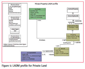
In spite of this fact, this form of acquisition can not be ignored, taking into consideration that not just the basic ownership right, but that other derived rights can be created in such large transnational land acquisitions, such as (possibly) Plantation or certain Use Rights. The class diagram for the private land acquisition in Figure 5 depicts the registered situation after a simple land transfer for a freehold property, whose ownership is ultimately detained by a non-natural person (a firm), representing the foreign investors. The most logical initial values where attributed to the LA_Party class: The LA_PartyType is a nonNaturalPerson, and the LA_ PartyRoleType corresponds to “citizen”. The spatial extent of the property right defines the boundaries of the Spatial Unit, coinciding with the LA_BAUnit register. This conforms with the most traditional view of the functions of a Land Registry. This is also the reason for this particular case being the one which uses mostly the LADM basic classes. Off course that for each particular country eventually adopting the Domain Model (LADM), specific attributes and code lists values should be considered for the different classes.
The consideration of using or even upgrading existing Land Registration Systems in those countries, must be confronted with the fact that, and according to World Bank estimates, only between 2 and 10% of the land, mainly urban, is held under a formal land tenure (Cuffaro and Hallam, 2011).
These concerns, however, should be raised when planning for implementation, and this paper is more concerned with finding if the domain model in LADM is capable of depicting the Land Administration System aspects of different forms of land grabbing.
One aspect that has to be considered at the domain modelling stage, however, is the Land Administration support for an investment which assures Sustainable Development.
In LADM, this can be seen as a different level of Spatial Units, which are to be defined through Public Regulations which are valid upon all different forms of property (commonly held, public or private).
In the last case, these could assume the form of administrative servitudes, temporary use of land, or even expropriation. The specifics of each type of restriction or responsibility should be defined through a Land Policy Act, having the goals of Sustainable Development, creating infrastructure and employment, while at the same time securing local land rights, as demanded by (Cotula, 2009).To this fact, consider the following quote from (Cotula, 2009):
‘Many countries do not have in place legal or procedural mechanisms to protect local rights and take account of local interests, livelihoods and welfare’.
Taking into consideration the above defined goals, a new diagram is created which depicts an hypothetical case of a beneficial large-scale land acquisition, as can be modelled through LADM by considering some specialisations from existing classes. This has been titled as “Sustainable large-scale land acquisition upon private land” and the corresponding class diagram is presented as Figure 6.
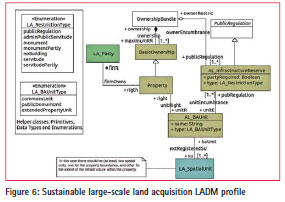
The diagram in figure 6 is of course an over-simplification of any hypothetical real case for a sustainable large-scale land acquisition. The purpose is to show how the basic LADM classes, together with classes from the Rights, Restrictions and Responsibilities profile in LADM (Annex F of ISO 2012), can support for the registration of such a case.
The diagram presents just the class names, for those depicted in the previous diagram, concerning private land. It adds however two specialised classes, one for a possible type of public based regulation (AL_ InfrastructureReserve), using the parent classes from Annex F, and the other for a new type of Land Registration, where both the basic ownership rights and the publicly imposed restrictions are registered for each basic administrative unit. As the note in the diagram clearly states, there should be more than one Spatial Unit for such cases, in order to quantify and locate the boundaries of the (public) regulation within the parcel. In this example, a portion of the land within the property should be reserved for a particular type of infrastructure, like rural irrigation.
To consider implementation of such a profile, known recommendations and best practices from documented cases should be studied in detail. It is expected that a number of Restrictions and Responsibilities of different types should be depicted for any given parcel, privately owned or under a long lease or concession over government or commonly held land.
Modelling of specialisations in ladm
This section shows what specialised classes had to be considered in the modelling of African Lands. We use in this paper the prefix AL to identify this, see figure 7. The use of prefixes in this way is very common in UML models in ISO standards.
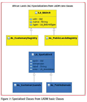
As already mentioned in section 4.1 a new kind of registry, or the integration into existing registry systems has to be considered to formalise such rights into each national property law. This is possible in LADM: registertype is an attribute of LA_Level. A level is a set of spatial units, with a geometric, and/or topological, and/or thematic coherence. For example: there can be one level of spatial units for an urban cadastre and another for spatial units for a rural cadastre. Or, another example: one level of spatial units to define basic administrative units associated with formal rights, a second level for spatial units to define basic administrative units associated with informal rights and a third level for spatial units to define basic administrative units associated with customary rights.
This paper shows what are the generalisation associations to the existing LADM basic Classes LA_ Party, LA_RRR, LA_BAUnit and LA_ SpatialUnit. LA_Level is associated to LA_SpatialUnit and can include the different registration types, see Figure 7. Even if they are specialised at this level of analysis, it is perfectly possible that there can be further specialisations for each African Country, taking into account their different cultural and historical background, and current legislation.
In the Spatial Unit component, each specialised class can be further associated with individual LA_Level classes, each with a particular spatial structure and its set of geometric and topology rules – which can be combined with different registry types. The LA_StructureType code list includes all the various spatial structure types, such as point or polygon, used in a specific land administration profile implementation.
Discussion
With its broad functionality LADM can support in the development of concepts for land administration systems which can be in support administration of multiple types of tenure. This is also valid for the Social Tenure Domain Model (STDM). Unconventional types of rights and spatial units can be included. Overlapping claims can be represented. This functionality allows a flexible approach in Land Administration and may result in fast availability of a cadastral map with a related registry of all (formal, informal, customary) in an area. This can then be used as a (more) solid base for large scale land acquisitions. In this way all claims can be brought to decision support. If this results in a more fair large scale land acquisitions depends on the way this application is organised: the functionality is there – it could be used in a proper way. A migration from STDM to LADM is possible without problems. LADM includes core class LA_BAUnit which is not available under STDM. A migration from STDM to LADM supports in building land administration infrastructure.
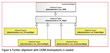
Further refinements are needed in this development. A more detailed alignment with the proposals as in Paasch et al (2013) is needed, this is very well possible on the basis of the contents of this paper, see Figure 8. The results of this alignment will be published in a next version of this paper.


 (35 votes, average: 1.29 out of 5)


Leave your response!