
Leica Geosystems launches Leica GMX901 GPS antenna
Leica Geosystems has launched Leica GMX901 GPS receiver with an integrated antenna for geodetic monitoring of sensitive structures. It streams single frequency code and phase data up to 1 Hz, providing the basis for position determination and deformation analysis.

Greece has suffered many times from big earthquakes that caused human victims as well as big damage to public and private infrastructure. However, the 1978 earthquake in Thessaloniki (Mw = 6.5) motivated the beginning of a more systematic confrontation of the impact of such phenomena. This happened because it was the first time that a powerful earthquake affected a big modern city of roughly one million of residents. Thessaloniki presented the formal characteristics of Greek urban built environment: buildings with 4 to 8 storeys, large population in numbers and density, mixed land use, traffic problems and lack of effective planning of management of natural catastrophes. After the Thessaloniki earthquake, a situation of chaos was created due to the panic, the destructions, the lack of information and the innumerable calls on help, but also on control of static condition and damage of buildings. By that time, there was no specific procedure for the inspection of buildings and infrastructure. However, after the first period of embarrassment, the state agencies reacted. Inspection forms were designed, printed and distributed during the first days after the earthquake. The buildings were inspected by two-member teams of civil engineers in order to be classified in categories with regard to their damage and usability. These paper inspection forms constitute a valuable database concerning the impact of the earthquake to the buildings of Thessaloniki.

SOME of the earliest known maps were made in Iraq which was drawn during 2400 BC for the purpose of land taxation. A Roman map dating 350 AD showed such topographical features as roads, cities, rivers and mountains. Although the basics of land surveying were known but the large scale maps before 16th century were limited to cities and other small areas. Up to the middle of 16th Century, there was little real knowledge of the geography of the most part of the world.

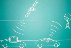
Inertial Navigation Systems (INS) are based on accelerometers and gyroscopes for position and attitude determination. Thus, INS is self-contained and autonomous. This makes INS an optimal option to be integrated with GPS, as both systems can complement each other to enhance positioning performance (Greenspan, 1996). On the one hand, the advantages of INS include high positioning (and attitude) update rates, and high short-term accuracy, both helpful in bridging the signal gaps between the GPS signal sampling epochs and the gaps due to signal outages. On the other hand, however, a major drawback of INS when operated as a stand-alone system is the time-dependent growth of systematic errors, which can be calibrated by GPS ranging measurements with consistent accuracy.
A book on Geographical Information System pertaining to Indian conditions was long awaited. This book under review in a way tries to fill this void. The authors in the Preface …

NSDI in India runs the risk of losing its relevance.
That’s the reality and that’s the challenge.
The NSDI VI meet in Goa (see sidebar) was not able to rejuvenate the movement which is slumped by the feel of fatigue and frustration.
It was a high moment in the movement of NSDI when last year on June 13, the Government of India came out with a resolution on the constitution of NSDI.
The resolution established National Spatial Data Committee (NSDC) as an apex national authority for formulating and implementing appropriate policies, strategies and programmes for the establishment, operation, management of the NSDI and utilization and any other activities related to spatial data in the country.
NSDI: Needs a magic wand
Integrating GPS/INS/PL for Robust Positioning
JINLING WANG, RAVINDRA BABU, DI LI, FRANICS CHAN, JINHO CHOI
Topographical mapping
P K VACHHER, R SRIVASTAVA
SEISIMPACT System
IOANNIS D DOUKAS, PARASKEVAS SAVVAIDIS
GPS Enabled Mobiles Reclassified
August 2007
GIS 14 Conference
14-15 August 2007
Vietnam
2nd Indonesian Geospatial Technology Exhibition
29 August – 1 September
Bakosurtanal; Jakarta
http://www.geospatial-exh.com/
September 2007
First International Summer School on Global Navigation Satellite Systems
Sep 02 – 09 2007
Berchtesgaden, Bavaria, …
Motorola RF switch enables location services
Motorola has announced several new enhancements to its RFS7000 RF Switch to support location services, management and security services including own and and third-party vendor services. www.motorola.com
European Union to sole-fund Galileo
Financing for Europe’s GNSS, Galileo, will come solely from the public sector, the European Commission declared, May 16, in Brussels. The public-private partnership (PPP) that had crippled the ambitious project was abandoned. EU Transport Commissioner Jacques Barrot said that the 27-nations bloc’s biggest-ever joint technological project could only reach orbit altitude if the public sector took full financial responsibility. He made the announcement as he presented three options for the bogged-down Galileo project: a complete EU takeover, partial public financing, or total elimination.
Barrot prefers to take over the project now, at an estimated public cost of about E2.4 billion in addition to the E1.5 billion already allocated in the 2007-2013 budget, and to issue a new tender to operate the system once it is built and in space by the end of 2012, according to recent forecasts. The European Space Agency would oversee construction and deployment of the satellites, though European aerospace companies would still supply technology, without assuming financial risk. EU Industry Commissioner Guenter Verheugen ruled out cancelling Galileo. “Galileo is from the European Commission standpoint an absolutely essential project,” he stated. “We don’t have an option of giving up on Galileo.” http://sidt.gpsworld.com


 (5.00 out of 5)