| Surveying | |
Australian Height Datum: Celebrating 50 years
This paper celebrates the 50th anniversary of the Australian Height Datum (AHD), along with its achievements and longevity, outlines its shortcomings and looks ahead to a new era of vertical datum determination based on GNSS and airborne gravimetry |
 |
|
 |
|
The Australian Height Datum (AHD) celebrates its 50th anniversary this year and remains Australia’s first and only legal vertical datum. Vertical datums define a reference for elevation comparisons and are essential for many applications relying on the flow of fluids. They are also of growing interest to a wider audience with an insatiable appetite for threedimensional digital twins of the real world.
Surveyors typically work with two types of heights in Australia: ellipsoidal heights referred to the Geocentric Datum of Australia (GDA2020, see ICSM, 2020a) and physical heights referred to AHD. In New South Wales (NSW), both are available through the Survey Control Information Management System (SCIMS), the state’s database containing approximately 250,000 survey marks on public record (Janssen et al., 2019).
Focussing on physical heights in NSW, this paper explores the achievements of AHD, outlines its shortcomings and looks ahead to a new era of vertical datum determination, based on Global Navigation Satellite System (GNSS) observations and airborne gravity measurements, culminating in the Australian Vertical Working Surface (AVWS, see ICSM, 2020b).
History of AHD
In May 1971, AHD (sometimes referred to as AHD71) was adopted by the National Mapping Council as the datum to which all vertical control for mapping was to be referred. In NSW, AHD replaced the Standard Datum, which was in use for some 80 years and defined by the value of Mean Sea Level (MSL) at the Fort Denison tide gauge, located on an island in Sydney Harbour and accessible via a survey plug that was installed in 1882 (and still exists) on the external wall of the former Department of Lands building in Sydney (Blume, 1975).
AHD was realised by setting MSL to zero at 30 tide gauges distributed around the coast of mainland Australia and adjusting 97,320 km of primary two-way spirit levelling across the country. MSL observations spanned three years (1966- 68) for all but one tide gauge, with earlier data over four years (1957-60) used at Karumba in the Gulf of Carpentaria. A subsequent adjustment also included about 80,000 km of supplementary one-way and two-way spirit levelling, in addition to and dependent upon the primary levelling. For the first time, this provided a nationwide network of physical heights known as the Australian National Levelling Network (ANLN) – a stunning and quickly implemented achievement that required enormous effort. Prior to AHD, many disconnected local height datums were used in each Australian state and territory.
In order to produce the most useful outcome within the framework of funds and time available, third-order levelling was used for the primary survey (Granger, 1972; Lambert and Leppert, 1976). At the time, this certainly provided an adequate basis for the topographic mapping program, general engineering purposes and the coordination of levelling surveys undertaken during gravity observations.
Anything more was considered as “striving against the forces of nature in order to achieve an impossible dream” (Lambert and Leppert, 1976).
An important time consideration was that third-order levelling could be accomplished with readily available equipment and by available professional staff found in both the government and private sector. Of course, third-order levelling was also much cheaper than first-order and second-order levelling. Considering the cost factor, as a rough rule of thumb, it was determined that an increase in a survey operation by a factor n involves an increase in time and funds of n2. Furthermore, even if better levelling standards had been adopted, this accuracy would have been swamped in the warping of the level surface to hold MSL equal to zero at the 30 tide gauges.
Practical realisation of AHD in NSW
On the ground, AHD was realised by networks of approved survey marks. Some states organised their own ground marking and benefited as a result, others left this to contract surveyors. Typically, AHD marks were placed at intervals of one mile in regional areas and two miles in remote areas, usually following major roads. The network was far denser in towns and cities. The separation was also varied to place marks at easily identifiable locations (e.g. crossroads, property entrances, hill crests and bridges) in an era predating GNSS positioning or even full mapping of the state. Often, ANLN marks were located close to existing road mile posts for easier retrieval. Marking typically consisted of five State Survey Marks (SSMs, brass plaque in concrete) followed by a Permanent Mark (PM, usually a stainless-steel rod with concrete collar), with this pattern being repeated for the entire level run. Sometimes, pairs of PMs on opposite sides of the road were placed to provide extra redundancy. Different level runs met and joined at junction points. Later, marking became more non-standard with entire runs sometimes consisting of only PMs or only SSMs and inter-station distances opting between miles or kilometres. Marks also varied with soil condition and when existing surveys were adopted or recycled.
Later, in the 1970s, NSW installed a series of Fundamental Bench Marks (FBMs) and Geodetic Bench Marks (GBMs).
These were high-stability marks designed to physically hold and preserve AHD. Based on a European design, they were modified for Australian conditions, akin to trigonometrical (trig) stations for height. FBMs and GBMs consisted of two to three marks installed in clusters, with the primary mark being located under a standard cover box. Marks consisted of stainless-steel rods driven to refusal in auger holes that were backfilled with sand to decouple the mark from any local soil movement. An extensive network of FBMs and GBMs was envisaged, but the program was abruptly terminated due to budget constraints.
While AHD was designed as a third-order levelling network, NSW set a far higher standard and supplemented, strengthened and improved AHD by observing the nation’s most extensive and ambitious network of first-order levelling (Figure 1), which extended throughout the eastern part of the state. While third-order levelling was performed by private sector contractors (whose participation was vital to the timely completion of AHD), first-order levelling was conducted by the Central Mapping Authority (CMA), now DCS Spatial Services, a business unit of the NSW Department of Customer Service (DCS).
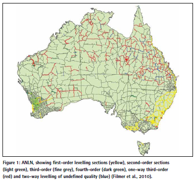
Over the years, further level runs of various quality including one-way levelling were added to extend the network and investigate anomalies. An extensive capillary network of levelling to mountain-top trig stations was also established, typically one-way only, connecting to the nearest ANLN mark. To this day, discussions continue about the existence and nature of any systematic errors that may lay dormant in this then fit-for-purpose survey methodology. For DCS Spatial Services, the era of optically (or digitally) observing extensive levelling networks ended well before the start of the 21st century, and inhouse geodetic levelling subject matter experts have since retired. Today, AHD is primarily derived from GNSS baseline networks, while digital levelling is only conducted for special projects, ad-hoc surveys or in some urban instances.
Adjustment of the ANLN
Prior to the adjustment, observed levelling data was corrected for the effect of nonparallelism of equipotential surfaces by applying the orthometric correction based on normal gravity (e.g. Granger, 1972; Roelse et al., 1975; Lambert and Leppert, 1976), which approximates true gravity. Orthometric corrections can be as large as several centimetres in mountainous regions where the level surfaces exhibit steeper slopes than in lowlands, e.g. 309 mm correction for the 146 km level run from Adaminaby into the Snowy Mountains versus 33 mm correction for the 155 km level run between Dubbo and Forbes.
AHD is considered a normal-orthometric height system because existing gravity observations were insufficient. Instead, a truncated normal-orthometric correction was applied to the spirit levelling observations, which only utilised normal gravity (referenced to the GRS67 ellipsoid approximating the Earth). For a detailed treatment of height systems and vertical datums in the Australian context, the reader is referred to Featherstone and Kuhn (2006) and Filmer et al. (2010).
The network of level sections and junction points was constrained at 30 tide gauges, which were assigned an AHD height of zero. In NSW, this included the tide gauges at Coffs Harbour, Sydney’s Camp Cove and Port Kembla, while Eden was excluded at the request of the Victorian and NSW Surveyors-General due to poor data (Roelse et al., 1975). The selection of Camp Cove (established in 1916) over Fort Denison, the second continuously recording tide gauge established in Australia in 1886 with records dating back even further and a long association with levelling datums, was attributed to the difficulty in making the crosswater connection (about 600 m) and the existence of a tidal gradient between the entrance to Sydney Harbour and Fort Denison (Blume, 1975). While there were many interruptions to the national tide gauge network recordings due to theft, vandalism and faulty gauges, acceptable results were obtained from the 30 gauges eventually chosen (Granger, 1972).
The least squares adjustment propagated MSL heights, or AHD heights, across the levelling network. This adjustment occurred in two phases due to the computational limits of the impressive CDC 3600 computer used at the time. In phase 1, five regional adjustments were made within boundaries approximating state limits. In phase 2, these were combined to produce two solutions: a minimally constrained solution with one station held fixed to assess the quality of the levelling, and the final adjustment constrained to the 30 tide gauges, run on 5 May 1971 (Granger, 1972; Roelse et al., 1975; Lambert and Leppert, 1976). The minimally constrained solution indicated a standard deviation of about 0.3 m in the centre of Australia. Despite the best efforts of surveyors, gross, random and systematic errors crept into the level sections and were distributed across the network within the adjustment.
Lambert and Leppert (1976) noted the average loop closure was ± 6 mm/√km but the loop closures did not conform to a normal distribution. The average correction applied to the regional adjustments was ± 3 mm/√km. An assessment of the standard weight of the minimally constrained adjustment was ± 7 mm/√km for all states but NSW. Detailed analysis indicated that the data for the south-eastern corner of NSW was statistically inferior despite the existence of mostly first-order levelling. Reportedly, this indicated that, after several years, first-order surveys tend to deteriorate to much the same order of accuracy as third-order levelling.
Owing to their distance off the NSW coast, Lord Howe Island and Norfolk Island are not covered by AHD and continue to use local historical height datums, the origins of which require more detailed investigation, documentation and public communication. As an aside, the Tasmanian AHD (often referred to as AHD-TAS83 or AHD83) was realised separately by setting MSL observations for only one whole year (1972) to zero at the tide gauges in Hobart and Burnie. It was propagated using mostly third-order levelling and adjusted on 17 October 1983 (ICSM, 2020a).
Shortcomings of AHD
Over time, significant and welldocumented shortcomings in the AHD realisation became apparent. In short, due to dynamic ocean effects (e.g. winds, currents, atmospheric pressure, temperature and salinity), tide gauge observations only spanning a period of three years and the omission of observed gravity, MSL was not coincident with the geoid at the tide gauge locations. The primary bias is due to the AHD realisation ignoring the effect of the ocean’s timemean dynamic topography, resulting in AHD being about 0.5 m above the geoid in north-east Australia and about 0.5 m below the geoid in south-west Australia. Together with uncorrected levelling errors, this introduced considerable distortions of up to about 1.5 m into AHD across Australia (e.g. Morgan, 1992; Featherstone and Filmer, 2012; Watkins et al., 2017). Many more investigations into the shortcomings of AHD can be found in the literature.
Observational blunders included those caused by observing in imperial units, where a whole foot was easily ‘dropped’ or ‘picked up’. Random errors included those caused by metrification in Australia, having to use metres in calculations although the data was observed in feet. However, there were also downright fraudulent level runs, including the fable of the contractor who supposedly adjusted out a misclose of more than seven feet while enjoying a cold beer at a pub in outback NSW. The independent approach of a few surveyors who did not fully conform to the prescribed specifications also caused issues (Lambert and Leppert, 1976).
Despite all this, AHD has, overall, continued to be a practical height datum that is fit for purpose, providing a sufficient robustness for many surveying and engineering applications, particularly over smaller areas (less than 10 km).
A new era of vertical datum determination
The era of GNSS technology ushered in the development of geoid or quasigeoid models to convert GNSS-derived ellipsoidal heights to physical heights, including the AUSGeoid models for Australia (Featherstone et al., 2019). This conversion is often needed because positions obtained by GNSS include heights referred to a reference ellipsoid. These heights are based purely on the geometry of the ellipsoid and therefore have no physical meaning, i.e. they cannot be used to predict the direction of fluid flow because they do not consider changes in gravitational potential. In practice, however, heights are generally required that correctly reflect the flow of fluids, e.g. for drainage and pipeline design.
Addressing the shortcomings of AHD in an era of ever-increasing usage and availability of GNSS and airborne gravity measurements, options for a potential new vertical datum were investigated at the national level (e.g. Featherstone, 2008; Filmer and Featherstone, 2012). This culminated in the development of AVWS as an alternative for users requiring higher-quality physical heights. AVWS allows early adopters to realise the full potential of modern technology, making height determination and transfer more efficient than with the traditional techniques used in the 1970s and 1980s.
Several countries have used, or are about to use, (nationwide) airborne gravity measurements to develop high-quality gravimetric quasigeoid models to modernise their national vertical datums. This includes the Canadian Geodetic Vertical Datum 2013 (CGVD2013), the New Zealand Vertical Datum 2016 (NZVD2016) and the North American-Pacific Geopotential Datum 2022 (NAPGD2022).
Gowans (2019) summarised the reasons for moving to vertical datums based on gravimetric quasigeoids: The maintenance of national levelling networks is no longer viable (too costly, too time consuming), and the results are too short-lived in countries subject to significant surface displacement. Gravimetric quasigeoid models are far more cost effective to maintain and less susceptible to surface movements. Their complete spatial coverage provides significant efficiency gains for industry when accessing the datum because propagating the datum from the nearest levelled benchmark(s) is no longer required. Basically, the datum is available everywhere, so there are no more ‘black holes’ as in AHD. However, digital levelling is still considered the most accurate technique for height transfer across short distances and will retain relevance in surveying for height-critical, local-scale projects. Since a model can only ever be as good as the data that informs it, the systematic acquisition of nationwide airborne gravity has proven to significantly benefit these quasigeoid models.
In Australia, efforts are underway to collect airborne gravity data over targeted regions to improve the Australian gravimetric quasigeoid model. DCS Spatial Services is currently preparing a business case for the modernisation of its Foundation Spatial Data Framework (FSDF), which includes an option to secure funding for airborne gravity surveys across the entire state. New airborne gravity data will significantly improve the gravity (and gravimetric quasigeoid) model and thus the accuracy of GNSSderived physical heights. It will also be used by geoscientists to further their understanding of Australia’s geological architecture and how it has evolved over time, as well as advance the geoscience that assists management of earth resources, infrastructure and natural hazards.
AVWS
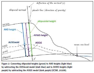
The Australian Vertical Working Surface (AVWS) is a new reference surface for physical heights in Australia, released on 1 January 2020. It provides an alternative for users requiring higher-quality physical heights (current accuracy about 4-8 cm) than those AHD can provide (accuracy about 6-13 cm) (ICSM, 2020b). GNSS users can access AVWS by applying the Australian Gravimetric Quasigeoid (AGQG) to their GDA2020 ellipsoidal heights, just like AUSGeoid2020 is used to obtain AHD heights (Figure 2). In practice, this means simply picking AGQG rather than AUSGeoid2020 as the geoid model in the GNSS rover or post-processing software.
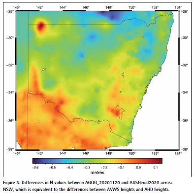
The initial version, AGQG_2017 (Featherstone et al., 2018), is the gravimetric component of AUSGeoid2020, providing the offset between the ellipsoid and the quasigeoid without being contaminated by the distortions inherent in AHD. The current version of AGQG (AGQG_20201120) differs from AUSGeoid2020 by between -1.8 m and +0.7 m across Australia, resulting in AVWS (normal) heights differing from AHD (normal-orthometric) heights by the same amount when determined via GNSS and the respective models (J. McCubbine, pers. comm.). In NSW, users can expect differences of between -0.5 m and +0.1 m (Figure 3). Geoscience Australia is working with all jurisdictions to continuously improve AGQG as new gravity data (particularly airborne gravity) is included and modelling techniques are refined.
Recently, current and future user requirements for physical height determination and transfer in Australia were investigated (Brown et al. 2019a, 2019b; McCubbine et al., 2019). It was found that AHD is still deemed fit for purpose over short distances (less than about 10 km) for applications such as cadastral surveying, civil engineering, construction and mining. However, users working over larger areas wanted access to higher-quality heights to reap the full benefits of modern technology for environmental studies (e.g. flood or storm modelling), LiDAR surveys, geodesy or hydrography. The study recommended a two-frame approach for heights, with AHD remaining as Australia’s legal datum and AVWS being provided as an alternative, analogous with the two-frame approach taken with GDA2020 (ICSM, 2020a) and ATRF2014 (ICSM, 2020c).
From a user perspective, AVWS provides improved access to physical heights, higher accuracy, increased efficiency, a surface without the known errors of the levelling network, better alignment with GNSS, and national consistency including a seamless onshore-offshore transition. Given that AVWS heights are not (currently) provided for benchmarks on public record, these AVWS heights can then be used as reference heights or starting points for spirit levelling surveys. While normal corrections should theoretically be applied to levelled height differences, this can generally be neglected in practice at the cost of introducing a small amount (sub-mm) of error (ICSM, 2020b).
Multiple height reference surfaces have been used in Australia for a long time to cater for certain applications, e.g. the Lowest Astronomical Tide (LAT) used for hydrographic applications. The introduction of AVWS simply adds to the spatial professional’s toolbox but also highlights the importance of metadata clearly specifying which datum or reference surface one is working in.
The future of AHD
Nearly half a century ago, Blume (1975) noted: “With the adoption in New South Wales of the Australian Height Datum (AHD) 1971 as a new levelling datum, the previously used Standard Datum has been superseded. The small difference between the two datums has resulted in many surveyors being vocally critical of the new datum and the opinion has been expressed that the introduction of AHD was an unwarranted alteration to a long established and acceptable system.” He continued: “Further investigation in connection with AHD is certain to continue and as a result of such research into tides, levelling, mathematical adjustments and revision, new values and possibly datums will arise. Because of the ever-changing level of the sea, any new datum would not necessarily agree with AHD, just as AHD did not agree with Standard Datum, which in turn did not agree with former datums based on sea levels. However, the need to replace AHD will doubtless require deep consideration in order to produce very strong and compelling reasons.”
These sentiments are just as true today, and his crystal-ball wisdom about the debate the profession will soon begin regarding AHD and AVWS is visionary. A testimony to its true quality and immense expense, AHD has long outlasted its horizontal datum counterparts (i.e. AGD66, AGD84, GDA94), and it is unlikely that GDA2020 will still be operating in another 50 years. Acknowledging that there can be only one legal vertical datum, it remains to be seen what the future holds for legal heights in NSW and Australia.
While DCS Spatial Services does not expressly advocate or legislate adoption of AVWS at this time (currently it is neither implemented nor supported in SCIMS), it is collecting and maintaining new ellipsoidal height datasets with the aim to investigate and contribute to future applications of AVWS.
Conclusion
AHD remains Australia’s first and only legal vertical datum and is still deemed fit for purpose for most applications. This paper has celebrated the golden jubilee of AHD along with its achievements and longevity, outlined its shortcomings and looked ahead to a new era of vertical datum determination based on GNSS and airborne gravimetry. AHD has been a stalwart of Australian surveying, replacing a collection of various local vertical datums and the then 80-year old Standard Datum, and successfully satisfied users ranging from mums and dads to engineers and geodesists for 50 years.
It has been the only vertical datum for most surveyors during their professional careers. That some should raise an eyebrow at even the thought of changing it, is quite understandable. But it is, like some of us, showing its age and deteriorating, despite the best efforts to maintain it. As the sun has set on the age of long level runs across towns, cities, shires, states and the nation, users want physical heights delivered at the push of a button, anywhere and anytime. Positioning tools and sensors now collect data over larger and larger swaths, at increased precisions, and local distortions in the fundamental datum can no longer be tolerated.
There can be only one legal vertical datum, and currently there is no planned push to replace AHD. DCS Spatial Services has yet to implement AVWS but continues to investigate and contribute towards it. The successful uptake of any alternative height surface(s), such as AVWS, will be decided by its users and their clients. They will soon play a key role in deciding the future of AHD and whether it will be able to celebrate its 75th or maybe even its 100th anniversary.
References
Blume P.H. (1975) Australian Height Datum and Standard Datum in New South Wales, Australian Surveyor, 27(1), 11-21
Brown N., Bollard N., McCubbine J. and Featherstone W. (2019a) Next generation height reference frame – Part 2/3: User requirements, Frontier SI report, https://frontiersi.com.au/ wp-content/uploads/2019/04/2-of-3- FrontierSI-P1.29-User-Requirements. pdf (accessed Apr 2021).
Brown N., McCubbine J. and Featherstone W. (2019b) Next generation height reference frame – Part 1/3: Executive summary, Frontier SI report, https://frontiersi.com. au/wp-content/uploads/2019/04/1- of-3-FrontierSI-P1.29-Executive- Summary.pdf (accessed Apr 2021). Featherstone W.E. (2008) GNSSbased heighting in Australia: Current, emerging and future issues, Journal of Spatial Science, 53(2), 115-133. Featherstone W.E. and Filmer M.S. (2012) The north-south tilt in the Australian Height Datum is explained by the ocean’s mean dynamic topography, Journal of Geophysical Research, 117, C08035, doi: 10.1029/2012JC007974.
Featherstone W.E. and Kuhn M. (2006) Height systems and vertical datums: A review in the Australian context, Journal of Spatial Science, 51(1), 21-42.
Featherstone W.E., McCubbine J.C., Brown N.J., Claessens S.J., Filmer M.S. and Kirby J.F. (2018) The first Australian gravimetric quasigeoid model with location-specific uncertainty estimates, Journal of Geodesy, 92(2), 149-168.
Featherstone W.E., McCubbine J.C., Claessens S.J., Belton D. and Brown N.J. (2019) Using AUSGeoid2020 and its error grids in surveying computations, Journal of Spatial Science, 64(3), 363-380.
Filmer M.S. and Featherstone W.E. (2012) Three viable options for a new Australian vertical datum, Journal of Spatial Science, 57(1), 19-36.
Filmer M.S., Featherstone W.E. and Kuhn M. (2010) The effect of EGM2008- based normal, normal-orthometric and Helmert orthometric height systems on the Australian levelling network, Journal of Geodesy, 84(8), 501-513.
Gowans N. (2019) NSW Surveyor General International Fellowship 2018: Investigation into vertical datums defined by gravimetric geoid models, Proceedings of Association of Public Authority Surveyors Conference (APAS2019), Pokolbin, Australia, 1-3 April, 13-26.
Granger H.W. (1972) The Australian Height Datum, Australian Surveyor, 24(4), 228-237.
ICSM (2020a) Geocentric Datum of Australia 2020 technical manual, version 1.5, https://www.icsm.gov. au/gda2020-and-gda94-technicalmanuals (accessed Apr 2021).
ICSM (2020b) Australian Vertical Working Surface (AVWS) technical implementation plan, version 1.3, https://www.icsm.gov.au/publications/ australian-vertical-workingsurface- technical-implementationplan- v13 (accessed Apr 2021).
ICSM (2020c) Australian Terrestrial Reference Frame (ATRF) technical implementation plan, version 2.3, https://www.icsm.gov.au/publications/ australian-terrestrial-referenceframe- technical-implementationplan- v23 (accessed Apr 2021).
Janssen V., Gowans N., Hine S. and McElroy S. (2019) Removing the uncertainty surrounding Positional Uncertainty and Local Uncertainty in SCIMS, Azimuth, 58(8), 28-32.
Lambert B.P. and Leppert K. (1976) A study of the Australian national levelling survey, Australian Surveyor, 28(2), 89-95.
McCubbine J., Brown N., Featherstone W., Filmer M. and Gowans N. (2019) Next generation height reference frame – Part 3/3: Technical requirements, Frontier SI report, https://frontiersi. com.au/wp-content/uploads/2019/05/3- of-3-FrontierSI-P1.29-Technical- Requirements.pdf (accessed Apr 2021).
Morgan P. (1992) An analysis of the Australian Height Datum 1971, Australian Surveyor, 37(1), 46-63.
Roelse A., Granger H.W. and Graham J.W. (1975) The adjustment of the Australian levelling survey 1970- 1971, Technical Report 12 (2nd edition), Division of National Mapping, Canberra, Australia, 109pp.
Watkins D., Janssen V., Woods A. and Grinter T. (2017) Investigating an anomaly in the Australian Height Datum at the NSW-Victoria border in Barham/Koondrook, Proceedings of Association of Public Authority Surveyors Conference (APAS2017), Shoal Bay, Australia, 20-22 March, 48-67.


 (2 votes, average: 1.00 out of 5)


Leave your response!