| Her Coordinates | |
“An ideal GNSS system is one that is impossible to spoof and difficult to jam”
 |
|
Professor Y Jade Morton is currently the Director of the Colorado Center for Astrodynamics Research at the University of Colorado Boulder where she mentors students, faculty, staff and an international network of collaborators throughout the world. Dr. Morton has made pioneering contributions to the advancement of GNSS receiver technology and its applications. She was awarded her Ph.D. in Electrical Engineering at Pennsylvania State University. She is a recipient of the IEEE Kershner Award, the Institute of Navigation’s (ION) Burka and Thurlow Awards, and is a Fellow of the ION, RIN and the IEEE. She is the current ION president.
In 2020, the Institute of Navigation (ION) celebrates the 75th year since its founding. On this occasion, it would be good to review the ideas and objectives that lay behind the creation of ION.
For the past 75 years, ION has been the world’s premier professional organization in advancing the art and science of position, navigation, and timing (PNT) and in providing a viable networking and educational platform for members coming from industry, academia, and government agencies. Today, the field of PNT is experiencing exponential growth, and PNT professionals are in high demand from the ever-expanding sectors requiring PNT expertise. Along with this exciting progress are challenges and new opportunities as our demographics are changing and the modern means of communicating, networking, and learning are constantly evolving. More than ever, ION must dynamically adapt and anticipate the changing trends in the field. With the support of a strong international member community, and the dedication of an excellent staff, ION is well-poised to play a crucial role of bringing together application engineers and product vendors, educators and students, scientists, researchers, and policy makers to maximize the positive impact of PNT technologies on society in the 21st century.
Would you like to elaborate on some of the achievements of the ION and also the challenges before?
ION has a wide range of achievements which include its unmatched conference and workshop organizations, numerous educational and outreach programs and initiatives, the government fellowship program, technical sponsorship and collaborations with other international professional organizations, journal and conference publications, and facilitation of standard development. I would like to highlight a few outstanding achievements which I personally witnessed since my affiliation with ION nearly two decades ago. The first and fundamental achievement is the success of ION’s conferences. Each ION conference offers a unique “flavor” and technical contents to an appropriate mix of audience in the PNT community. ION constantly adapts its conferences to the need of the community. For example, in 2013, ION launched the Pacific PNT meeting to address the growing interest in the development of PNT systems and applications in the Pacific Rim countries. This bi-annual meeting has attracted a large proportion of first-time attendees from Asian Pacific countries. I am looking forward to the 5th Pacific PNT meeting, now planning to be held in Hawaii in April 2021. Since 2004, ION has been the lead sponsor for international student competitions, such as the autonomous lawn mower and autonomous snowplow competitions. These competitions have inspired many undergraduate students to pursue a career in the field of PNT and automation. Another major achievement is the African GNSS Outreach program sponsored by the ION Satellite Division. For the past decade, led by past ION president Pat Doherty, this outreach program has educated over 500 graduate students and faculty from African countries and other developing nations on the fundamentals of satellite navigation and applications. Some of the students are now recognized experts in the field. ION has sponsored (and committed to sponsor) 10 government fellows during the past two decades. The government fellowship program, sponsored in cooperation with the American Association for the Advancement of Science, offers ION members a unique educational experience while providing the US government a resource of technical experience and private sector perspectives, which ultimately helps to foster public policy on the issues that affect our society and our profession. Finally, the ION community has been the driving force and the liable resource that has led to the establishment of a number of much needed technical standards, including the recently adopted GNSS Software Defined Receiver Metadata Standard.
As a professional organization in a rapidly evolving field, ION has faced (and continues to face) many challenges. For example, PNT is a traditional engineering field dominated by men. Such dominance was reflected in the composition of the ION community. In recent years, however, under the leadership of past president Dr. Dorota Grejner-Brzezinska, ION and its sponsors have taken a number of initiatives to promote, encourage, and support women in PNT and successfully improved the diversity in ION events and leadership teams.
Another challenge is the evolving demographics of the field of PNT. New generations of PNT professionals adopt new means of communicating and networking. ION must dynamically develop strategies to keep engaged with the changing field. Finally, ION’s journal NAVIGATION has long faced challenges from competitors and ranking and impact factor issues. In recent years, however, thanks to the relentless effort of our editors, Drs. Boris Pervan and Richard Langley, the team of associate editors, the ION staff, and countless reviewers, NAVIGATION is gaining greater recognition, attracting quality submissions, and ramping up its ratings.
Can you briefly touch upon your research interest in ‘intersection of satellite navigation technologies and remote sensing’ and other research priorities?
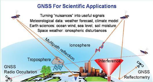
Satellite navigation, as implied by its name, is designed for navigation applications. However, it is well-known that some of the largest and toughest errors associated with satellite navigation solutions are the so-called propagation effects, including multipath, ionosphere, and troposphere errors. The satellite navigation community treats these errors as nuisances and has devoted much effort to mitigate them. However, these errors contain signatures of the signal propagation environments and can be used to extract information on the environment. The remote sensing community has been working on retrieving atmospheric profiles, ionospheric states, urban propagation channel conditions, ocean surface wind and roughness, and land cover soil and vegetation moisture, etc. by using ground, airborne, and LEO satellite-based GNSS receiver measurements. Because of the large number of navigation satellites, their welldefined signal structures, and their distributed global coverage, navigation satellite signals are ideal signals-of-opportunity for remote sensing applications. However, the measurements tend to be very challenging as they are often associated with highly disturbed, weak signals. By working in the “intersection of the satellite navigation technologies and remote sensing”, our goal is to integrate our expertise accumulated in the navigation community and knowledge of scientific interactions of the signals with the environment to advance our understanding of the space and Earth surface environment.
What is your idea about a Perfect GNSS System?
An ideal GNSS system is one that is impossible to spoof and difficult to jam. Its signals should be relatively simple and elegant so that receiver signal processing can be done in a power-efficient manner and allow fast acquisition and accurate tracking. It should be inter-operable with other GNSS and backward compatible with its predecessors. It should have limited multipath errors even when operating in urban environments. It should be built on a reference frame and time standard that can be easily adopted by a wide variety of applications and systems across geographical and political borders. Finally, it should support multiple carriers and both data and pilot channels on all carriers to enable receivers operating in challenging environments. The carriers should have sufficient spectral separations to ensure accurate estimations of ionosphere errors, or be at frequencies where ionospheric and atmospheric effects are insignificant.
Would you like to comment on GPS III and also on other existing and upcoming systems including NavIC?
Since December 2018, three GPS III satellites have been launched. An additional seven GPS III satellites are under construction by Lockheed Martin and are expected to be launched by 2023. In addition to the legacy L1 C/A, L1 and L2 P(Y), and modernized L2C, L5, and M code signals, GPS III satellites also broadcast a new civil signal, the L1C. The L1C signal consists of a pilot and a data component with an asymmetrical power split (75% for pilot and 25% for data) and is transmitted in phase with orthogonality achieved by the code division multiplexing. The data component uses BOC (1,1) modulation to achieve backward spectral compatibility with the legacy L1 C/A signal. The pilot component features a Multiplexed BOC (MBOC) modulation, which enables GNSS interoperability with BDS, Galileo, and QZSS. GPS III satellites transmit an updated civil navigation message, CNAV-2, which employees sophisticated error detection and correction scheme. CNAV-2 also includes additional parameters such as the GPS/GNSS time offset (GGTO) parameters for multi-GNSS applications and Earth orientation parameters for space borne applications. In addition to the advances in signal modulation and navigation data message transmission, GPS III satellites carry laser retro-reflectors to allow tracking of satellite orbits independent of radio signals, thereby allowing satellite clock errors to be disentangled from ephemeris errors. At the time of this interview, Lockheed Martin is selected to build up to 22 GPS III Follow On (GPS IIIF) satellites by 2034. The GPS IIIF satellites are planned to incorporate additional capabilities such as Distress Alerting Satellite System for search and rescue, Regional Military Protection (RMP) capability, satellite crosslinks for rapid command and reduced age of data, spot beam antennas, and a fully digital navigation payload, while maintaining compatibility with next generation Operational Control System (OCX) and the existing GPS constellation. Compared to its predecessors, GPS III is inching closer to the ideal GNSS system discussed earlier.
The other GNSS also had an exciting year. GLONASS is undergoing a transition stage with the launch of the last GLONASS-M satellite (second generation GLONASS satellites) in March 2020. Already, two of the third generation GLONASS satellites, GLONASS-K1, are launched and the remaining batch of nice are planned for launch by 2023. This will be followed by GLONASS-K2 satellites, which are redesigned systems hosting a passive hydrogen maser AFS with expected one-day stability of 5×10-15 (0.3 m SISRE) and transmitting a full suite of modernized CDMA signals in the existing L1 and L2 bands as well as the L3OC signal. This year also marks a special milestone for Galileo and BDS. Galileo is expected to be fully operational by the end of 2020 when two new Galileo satellites are scheduled to be launched to bring the total number of the operational satellites in the constellation to 24. Already, Galileo has achieved an impressive SISRE of 25cm (95%), despite the 6-day service outage that occurred in July 2019. This year also sees Galileo’s transition to its second generation satellites with the first order of four satellites expected to be under contract by the end of 2020. BDS achieved fully operational status in June 2020 with the launch of the final satellite that completes the BDS-3 network. The 30 operational BDS satellites offer the most orbital diversity among all GNSS, including 24 MEO, three IGSO, and three GEO satellites, to provide both global services and enhanced regional services, as well as other featured services such as BDSPPP, BDSBAS, regional message communication, and global SAR functions. BDS reached this impressive status with an unprecedent 21 successful launches from November 2017 to June 2020. All BDS-3 satellites are equipped with inter-satellite links (ISL) to drastically improve satellite orbit accuracy by nearly 100% to 30 cm.
There are now three potential regional navigation satellite systems (RNSS), serving the Asian Pacific and Indian Ocean areas. Two of the RNSS, QZSS and NavIC, have been fully operational in recent years. QZSS currently has four satellites in IGSO orbit. A QZSS-1R satellite is expected to be launched later in 2020. QZSS is also expected to take over the transmission of MTSAT, Japan’s SBAS in 2020. Three additional satellites are planned to be launched after 2023. QZSS satellites transmit signals compatible with GPS L1 C/A, L1C, L2C, and L5. NavIC currently has seven active satellites, three GEO and four IGSO satellites, and has plans to extend to 11 satellites in the future. NavIC satellites transmit signals at L5 and S band. A messaging interface is embedded in the NavIC system to allow command center to send warnings to specific geographic areas. The Regional South Korea Positioning System (KPS) is a new RNSS currently under planning. KPS is expected to launch three GEOS and four IGSOs to cover South Korea and about 1000km of Pacific Ocean and Australia.
This is a world of multi-GNSS systems. What advantages do you see about this scenario?
Multi-GNSS offers several advantages. The larger number of combined satellites in space improves the geometric diversity and hence the PVT solution accuracy. This is especially true in urban environments where a large number of satellites may be blocked by buildings. The redundancy introduced by these extra satellites also improves the signal availability and reduces the probability of blackout (or complete loss of navigation solutions). Multi-GNSS also provides more rich spectral diversity and improves the jamming resistance. Finally, I believe the biggest winner in this multi- GNSS age is the remote sensing and scientific applications. With each satellite ray-path serving as an observable of the signal propagation environment, a larger ensemble of transmitters will provide improved spatial resolution and coverage of the physical world of interest.
What is your take on FCC’s Ligado spectrum decision?
Like many others in the PNT community, I think the decision will have a profound negative impact on satellite navigation and many important applications. There have been many discussions on the impact of the broadband system on navigation applications. I would like to highlight its potential impact on remote sensing applications. Two notable remote sensing applications are the GNSS radio occultation (GNSS-RO) and GNSS reflectometry (GNSS-R). GNSS-RO has been recognized as a major data source of atmospheric profiles needed for weather models, climate studies, and ionosphere monitoring. It retrieves these measurements by receiving and processing the Earth limb scan of GNSS satellite signals. GNSS-R utilizes reflected GNSS signals from the Earth’s surface to infer the surface properties such as hurricane wind development, evolution of wetland, snow-water storage, ice and vegetation coverage, and sea level changes. For both GNSS-RO and GNSS-R applications, the receiver antenna is pointed towards Earth’s surface. Terrestrial transmissions of broadband radio signals will directly enter the antenna’s main lobe to interfere with the processing of the already weak and disturbed signals. The FCC’s decision is indeed a piece of very “disturbing” news for the GNSS remote sensing community.
With increasing dependence on GNSS, how do you perceive the threats like interference, jamming and spoofing?
Interference, jamming, and spoofing will always be there and may get smarter over time. As we move into a world that becomes more reliant on autonomous systems, the threats will have an increasingly higher impact. We must be creative in developing techniques to detect and mitigate both intentional and un-intentional adversary factors. These techniques are, and should, continue to be addressed at multiple levels, including antennas, signal design, receiver signal processing, and the integration with other complementary sensors.
Given this, what’s your opinion on GNSS backups?
GNSS backups serve society’s interest. While there are many alternative navigation resources being explored to offer solutions when GNSS is compromised, none of these sources offer the type of coverage provided by GNSS that we (and our applications) are accustomed to. This is particularly true for safety-of-life applications. Dedicated GNSS backups will be very helpful for these applications.
What technology trends do you envision in GNSS receivers in the near future?
Today’s GNSS receivers are customized for a vast number of specialized applications with wide ranging complexities, capabilities, and resource requirements. On the high-end of the spectrum are reference monitoring stations which are capable of direct sampling the entire L-band spectrum and perform signal monitoring, oscillator anomaly detection, interference analysis, and ionosphere characterization in real time. In the middle sector are high accuracy consumer and scientific applications. For the consumer sector, RTK receivers are now capable of providing mm-level carrier phase-based relative positioning; and PPP technologies can yield sub-cm level standalone absolute positioning. For scientific applications, airborne, spaceborne, and ground-based systems are designed to track nuisance features such as reflected signals, signal bending angles, and carrier phase disturbances that are routinely removed and filtered by navigation receivers to retrieve information on our space environments and Earth surface conditions. On the low-cost, high-volume mass market end, current generation cellphones have integrated the entire PNT functionality utilizing all GNSS constellation signals and carriers into a single CMOS chip that consumes a few mW, costs a few dollars or less, and with performances that outshine aviation-grade GPS sets from merely a decade ago. On the further extreme low-cost end are asset tracking devices that periodically take a “snapshot” of GPS signals for post-processing to achieve localization at a few meters of accuracy.
The future trend of GNSS will be driven by continued diverging needs of specialized applications and to ensure efficient sensor integration. Such needs will favor more open architectures and standardization. While ASICs have demonstrated to be the best in terms of performance and low power requirement, software-programmable ASICs will most likely be the dominant platform for future GNSS receivers due to their flexibility and the maturing technologies.
How do you think the GNSS positioning technology can take the advantages of alternative positioning technologies such as cell phones, Bluetooth and WiFi, etc?
Using alternative positioning technologies including other radio signals-of-opportunity to augment GNSS has been an active research area for a while. These alternative technologies are especially helpful in densely populated urban areas where GNSS signals may be blocked. For defenserelated applications in GNSS-denied areas, they are also important. There is definitely synergy between the alternative navigation technologies and GNSS-based systems. The synergy should be thoroughly exploited to ensure seamless transitions between GNSS-based navigation solutions in benign environments and multi-sensor augmented alternative products under challenging conditions.
Would you like to comment on autonomous navigation?
There is no doubt that autonomous navigation will improve productivity, safety, and resource utilization efficiency. Autonomous navigation is an unstoppable trend and leading industries are hopping on the wagon. But there will be challenges along the way. A critical piece in enabling autonomous navigation is the integrity of navigation solutions. Sensor integration holds the key to improving integrity measures. Some of the factors we mentioned earlier (such as alternative navigation technologies, backup systems, and multi-GNSS) are all important pieces that will make it happen.
You have a long association with academia. Given the pace of technology evolution, what challenges do you see before the academic community and PNT/GNSS education?
PNT/GNSS are interdisciplinary fields. We often see PNT/GNSS educators spreading across multiple departments, such as aerospace engineering, civil engineering, computer science, electrical engineering, geomatics engineering, mechanical engineering, physics, survey, etc. Unlike other traditional, well-defined disciplines, PNT/GNSS curriculum requires a wide mix of subjects. As a result, there are only a limited number of universities in the US and in other countries that have dedicated curriculum for PNT/GNSS. Such limited educational resources cannot meet the high demand for PNT/GNSS experts in industry and government laboratories. This is a major challenge in the near future before the academic community. A side effect of the imbalanced educational resources and industry demand is the challenge for universities to retain high caliber students in PhD programs. Students get irresistible offers from industry as soon as they have had experience with PNT projects.
How do you see the employment prospects of the students pursuing a career in PNT and GNSS?
As I stated above, there is a high demand for students with masters and PhD degrees in GNSS and PNT from private industry and government laboratories. We cannot graduate them fast enough! And they get incredible offers. As a result, our GNSS classes are getting very large. For example, there are 85 students enrolled in Professor Penina Axelrad’s graduate level class “Introduction to GNSS” this fall at the University of Colorado, Boulder. Out of ~200 seniors that are working on senior capstone projects this year at our Aerospace Engineering Department, nearly 50 of them are on projects with a focus on or having elements related to PNT.
What likely impacts do you anticipate due to the ongoing Covid-19 crisis on the PNT and GNSS community?
COVID-19 is impacting everyone. For the PNT/ GNSS community, there are both short-term and long-term impacts. In the short-term, COVID-19 is preventing in-person meetings, limiting laboratory work, and delaying project completion. In the longterm, like many other disasters and crises that occurred in the past, COVID-19 may stimulate, accelerate, or change the course of some technology development such as contact tracing, autonomous systems, and transportation, all of which are reliant on PNT.


 (3 votes, average: 4.67 out of 5)


Leave your response!