| Applications | |
An analysis of the Turkish Cadastre in view of the Cadastre 2014 Vision
The paper carries out an analysis on the Turkish cadastre in view of the Cadastre 2014 statements and then provides some proposals to improve the system |
 |
|
A well-functioning cadastre is essential for securing rights in land and property, wealth generation, and contributing to better land and environmental management (Jones and Land, 2012). If so, what makes a cadastre well-functioning? Actually the response may change in the course of time because cadastral systems have a dynamic nature especially with the changing technological and changing humankind to land relationship. Therefore, cadastres need to be re-engineered over time to response expectations of the societies in modern ways. Considering this need, the International Federation of Surveyors (FIG) published a vision called “Cadastre 2014” describing characteristics of future cadastral systems in 1998 (Kaufmann and Steudler, 1998).
This vision has become a benchmark to evaluate cadastral systems and directed the re-engineering works in cadastre in many countries. One of those countries where Cadastre 2014 vision has had an important infl uence is Turkey. As a result of that infl uence, separation between maps and registers has been abolished in the country. The Turkish Land Registry and Cadastre Information System, combining land registry and cadastre data, and thus a new data model have been developed and implemented. Paper and pencil cadastre has been transformed into the digital one and a new project for renewal of the old cadastre maps was initiated. The private sector has gained importance in cadastre and cadastre works were completed by private surveyors. A new licensing system both for surveyors and offices of surveying and cadastre have been introduced into the cadastre and some parts of the official works in cadastre transferred to those surveyors and offices. The public sector started to concentrate largely on supervision and control of the works.
Although all those developments have been carried out in the Turkish cadastre in the last decade to modernize the system and to response expectations of the society, there are still some works to do in view of Cadastre 2014 statements and modern cadastral trends in Turkey. In this context, this paper, firstly, describes the works carried out in the Turkish cadastre based on the six statements of the Cadastre 2014. Then, it discusses the works needed to be done in the country in the light of modern trends and visions in the cadastre. Finally, it is concluded with some proposals to improve the Turkish way of cadastre.
Cadastre 2014 and the Turkish cadastre
Cadastre 2014 is a vision document published by Federation of International Surveyors (FIG) in 1998. The document provides a vision through six core statements for future cadastral systems. This section evaluate the current situation of the Turkish cadastre based on these six statements.
Mission and Content
According to the Cadastre 2014, “especially after World War II, land use planning, environment protection, noise protection, construction laws, protection against danger caused by natural phenomena, and so on, were regulated by public laws. These laws define areas where certain things are permitted or forbidden. The boundaries of these areas are in principle independent from the private property boundaries, but they have an impact on the possible use of the land. These definitions under public law can have an impact on the property right of the owner, but because they are not part of the official register, they are not subject of the principle of publicity. Although there is in most cases a welldefined procedure for the definition of the respective boundaries of the rights and restrictions, the results are not publicly known. The respective maps are presented during the consultation process of a law-setting before it is put to the vote. Afterwards this documentation is kept with the responsible governmental unit. Interested citizens and organizations can find property information about a piece of land in the land registry. But they must make further efforts to get information about other rights and restrictions that have an effect on the legal situation by making a survey at different governmental organizations. If citizens fail to find out all aspects of the legal situation of a piece of land, they risk the loss of money and time spent for inadequate land use or land use planning. Cadastre 2014 must correct this situation, which is becoming more and more precarious. It must document, in a safe manner, all legal aspects of land. It will be necessary in future for existing and new legal land objects introduced by traditional, private and public law, that the boundary definition and the correctness of this definition are verified carefully, and that the results of the definitions are published in an official public register. In this way the security of land tenure, land use, and resource management will be maintained in view of the land owners and of the societies as a whole.” Therefore, “Cadastre 2014 will show the complete legal situation of land, including public rights and restrictions!” (Steudler and Kaufmann, 1998).
In Turkey, main duties of the cadastre organization described in the Cadastre Law (Date: 1987) is property adjudication, construction of boundary markings, surveying of land parcel boundaries, drawing cadastre maps, registration of parcel boundaries and owner information, sustaining land registry and cadastre records and thus providing a basis for land information system. It means main purpose of the Turkish cadastre is building and sustaining land registry and cadastre records to provide security of the real estate ownership. Some rights and restrictions like easements, right of way, usufruct, mortgage, etc. are recorded in the land registry but generally it is not possible to see those rights and restrictions on cadastre maps. There are some academic and institutional studies to show the complete legal situation of land in the Turkish cadastre but these are in very early stages of success. Considering this proposed mission of Cadastre 2014 will be a highly important characteristic of modern cadastres in the future, the Turkish cadastre should more intensively study on realization of this statement.
Organization
Cadastre 2014 states that “most countries have a land recording system consisting of cadastre and land registration components. The cadastral part is normally handled by surveyors, while notaries and lawyers take care of the land registration part. This subdivision has often resulted in two different organizational units dealing with the same matter. Because of the traditionally available technological possibilities, the working procedures of land survey and land registration have been quite different. Cadastre surveying and mapping require special skills to obtain a sufficient result, whereas land registration process was very close to bookkeeping. So the work was subdivided in the past according to the required skills. The correct treatment of the legal aspects of land property transfer matters was ensured by the requirement of a license for land surveyors and by the special education of notaries and lawyers. Advantage of this type of organization is a certain cross-control that can help to eliminate errors. The disadvantages of such solutions are: (i) The system is tiresome, the participants in the land market have to address two different authorities for land transactions; (ii) the information is partly redundant which results with the risk of inconsistencies; (iii) every organizational unit has its own fees to at least partly recover the cost of maintenance of the system.” Therefore, the separation between ‘maps’ and ‘registers’ will be abolished! in Cadastre 2014 (Steudler and Kaufmann, 1998).
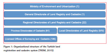
Organizational structure of the Turkish Cadastre has some differences from the general structures described above. While cadastre works are carried out by the surveyors in the cadastre directorates, land registration works are carried out by employees in the land registry directorates (Figure 1).
It means, notaries or lawyers do not take part in the Turkish land registration system. The separation between cadastre maps and land registers had been a problem until beginning of the 2000s in Turkey. At the beginning of this century, a new project called as Land Registry and Cadastre Information System of Turkey was developed. The project has targeted to transfer the paper based land registry and cadastre data into a digital environment using a standard framework throughout the country and thus to take land registry and cadastre data use to the next level by spreading its benefits to people, businesses and multiple sectors by facilitating better access to real estate information through the e-government platform (Mataracı and İlker, 2002; Ercan, 2003; Zakout, 2008, Çete et al., 2010). Digitization of land registry data was completed but transferring cadastre maps into digital environment is still continuing. After finalization of the project, land registry and cadastre data will be combined in a unified system in the country. The responsible authorities from land registration and cadastre are local directorates of land registry and cadastre in local level. There is no one agency responsible from both land registration and cadastre but in regional and national levels the responsible authority is one: Regional Directorates of Land Registry and Cadastre (LRC), General Directorate of LRC and Ministry of Environment and Urbanization. Therefore, there is no considerable problem in harmonization of LRC data in Turkey.
The changing Role of Maps
According to the third statement of Cadastre 2014, “the function of cadastre maps must be re-defined. Maps will lose the function of information storage. They will serve in future simply to represent information derived from data stored in data bases. The result of this process is a data model of the real world. The exchange of data models will become common practice in the distribution of cadastral information. This new procedure has several advantages: (i) Type, scale, and content of a representation can be chosen according to the needs; (ii) the information is stored once and different products are derived from the same data; (iii) the digital model is easy to handle, and data representing the model cannot be destroyed physically as can traditional maps; (iv) distribution and publication of cadastral information is easily possible with the help of the exchange of digital data models.” Therefore, the cadastral mapping will be dead and long live modelling will be available in Cadastre 2014 (Steudler and Kaufmann, 1998).
During introduction of the Land Registry and Cadastre Information System of Turkey (in Turkish abbreviation, TAKBIS), a data model has been developed at the beginning of the 2000s. However, afterwards, Land Administration Domain Model (LADM) has become an international standard (ISO 19152). Considering the LADM supports the implementation of Cadastre 2014, shows the complete legal situation of land, including public rights and restrictions and does not separate maps and registers (Lemmen and van Oosterom, 2014), data model of the TAKBIS should be transformed into LADM to benefit from all these strengths of the LADM in Turkey.
Information technology
Cadastre 2014 says that “the traditional land recording procedures are increasingly computerized. Computerassisted work has proven to be much more efficient. That is why bookkeeping all over the world is handled with help of computer programs. There is no reason why land recording should not make use of this technology. The handling of spatial objects requires more sophisticated software solutions than bookkeeping, but progress in this domain is accelerating. Spatial objects are nowadays not far from becoming normal objects of information processing. Aside from the bookkeeping information, the geographical information can also be processed easily, and computer-based technology will be the most efficient and cost-effective way to resolve the problem of land recording.” Therefore, paper and pencil – cadastre will have gone! in Cadastre 2014 (Steudler and Kaufmann, 1998).
Cadastre works have been carried out in digital environment since 1987 when a new Cadastre Law enacted in Turkey. Since initialization of the Land Registry and Cadastre Information System Project, both land registry and cadastre data have been transferred and maintained in computer environment. Surveying data are collected, stored, maintained and delivered in digital form, while legal documents are delivered on paper. Landowners can get property data over the e-government platform.
Privatization
Cadastre 2014 states that “within the worldwide trends of deregulation and privatization, tasks handled until now by the public sector are being transferred to the private sector. Within the framework of New Public Management (Schädler, 1995), public administration units are being converted to private or mixed organizations, doing the work in a fl exible and consumer-oriented manner. These trends will also involve the cadastral organizations. In this field we find a lot of operational work that can be done by the private sector as well as or even better than the public sector. The majority of tasks necessary to build up and to maintain a cadastral system can be handled by the private sector without endangering the security of the land recording. Also the preparation of titles and deeds and the registration of titles and deeds may be carried out by the private sector or by mixed-economy organizations. It is not necessary for the public sector to do all the work itself. The public sector nevertheless, plays an important role, because it has to guarantee the legal security of the land recording system. It must be able to implement efficient and powerful procedures for supervision and control of the work. This can be achieved by strict and permanently applied computer-assisted control procedures; by the careful selection, education, and examination of staff; and by the financial involvement of the public sector in mixed-economy organizations.” As a result, Cadastre 2014 will be highly privatized! Public and private sector are working closely together! in Cadastre 2014 (Steudler and Kaufmann, 1998).
While all cadastre works had been carried out by Local Directorates of Cadastre until 2004, after that time, technical part of cadastre works has been contracted to private surveyors in Turkey. The General Directorate of Land Registry and Cadastre studied on transferring some workloads of Local Cadastre Directorates to private sector. Then, Licensed Offices of Surveying and Cadastre (LOSC) were introduced into cadastre in 2005 (Official Gazette, 2005). In this context, sub-districts of cadastre throughout the country were designed by taking workloads of the existing cadastre directorates into account. The LOSC have been authorized to carry out many cadastre works. Application of the cadastre maps into the field and showing boundaries of parcels in the relevant area are carried out by the LOSC. These works are not supervised by the cadastre administration. However, the LOSC works on use type change of a parcel, establishment and removal of easement rights and consolidation of parcels are supervised by the Province Directorates of Cadastre (Circular Letter, 2010). The licensed surveyors work as public officials and the losses they caused are compensated by them. As a result, nowadays, public and private sector are working closely together in cadastre works, while land registration works are still carried out by the directorates of land registry in the country.
Cost Recovery
According to the Cadastre 2014, “cadastral systems need considerable investment. But the land documented and secured by the cadastre represents a multiple of the investment. The investment and operation costs have to be paid back at least partially by those who profit.” Therefore, “for the land recording systems there should be introduced a controlling mechanism that takes into consideration the real costs and benefits of the system, separates fees and taxes, and refl ects on possibilities of how the cost of the system can be covered by adequate fees. It seems to be realistic that land recording can be organized in such a manner as to achieve a return on investment.” It should be provided that Cadastre 2014 will be cost recovering! (Steudler and Kaufmann, 1998).
The Turkish land registry and cadastre system is a self-funding even profitable system. As stated above, the country has a dual system in local level of land registration and cadastre. It means, land registration and cadastre directorates work separately. However, in regional and national levels they work under the same regional and national directorates and ministry. Thus, they are thought and evaluated together. This situation prevents to see the cadastre as a costly system. Furthermore, land registration and cadastre is seen as a profitable system in the country. As an example, the yearly income of the land registry serving about 20 million citizens a year was more than 2.5 billion USD in 2013 (TKGM, 2015).
Conclusion
Cadastre 2014 has guided re-engineering processes of land registration and cadastre systems in many countries. It has been also a benchmark during improvements of the systems. Thanks to this vision document, many countries have been sure that their re-engineering processes were on the right way. Turkey is one of those countries. At the beginning of this century, a new project called as Land Registry and Cadastre Information System of Turkey (in Turkish abbreviation, TAKBIS) was developed. The project has targeted to transfer the paper based land registry and cadastre data into a digital environment using a standard framework throughout the country and thus to take land registry and cadastre data use to the next level by spreading its benefits to people, businesses and multiple sectors by facilitating better access to real estate information through the e-government platform. After finalization of the project, land registry and cadastre data will be combined in a unified system in the country. Since initialization of the TAKBIS Project, both land registry and cadastre data have been transferred to and maintained in computer environment. Technical part of cadastre works has been contracted to private surveyors since 2004, and the General Directorate of Land Registry and Cadastre studied on transferring some workloads of Local Cadastre Directorates to private sector. Then, Licensed Offices of Surveying and Cadastre (LOSC) were introduced into cadastre in 2005. The licensed surveyors work as public officials and the losses they caused are compensated by them. As a result, nowadays, public and private sector are working closely together in cadastre works, while land registration works are still carried out by the directorates of land registry in Turkey. However, there are still some needs for improvements in the Turkish land registration and cadastre based on the Cadastre 2014 statements. For instance, a project to provide that cadastre shows the complete legal situation of land, including public rights and responsibilities is needed to be carried out. Land registry and cadastre data must be up-to-date and complete. Data model of the TAKBIS should be revised based on the Land Administration Domain Model (LADM). Accessibility of land registration and cadastre data should be extended to make easier the use of TAKBIS services for the citizens.
References
Circular Letter, 2010, Circular Letter about Licensed Surveyors and Surveying Offices, Official Web site of the General Directorate of Land Registry and Cadastre, http://www.tkgm.gov.tr. (in Turkish)
Çete, M., Palancıoğlu, H. M., Geymen, A., Alkan, M., 2010. The Turkish cadastral information system and lessons learned, Scientific Research and Essays, Vol. 5 (7), pp. 625-633.
Ercan, O., 2003. Geodesy and land information system of TKGM, The TUJK Scientific Meeting, the Workshop on Geographical Information Systems and Geodetic Networks, Konya, Turkey, pp. 75-82. (in Turkish)
Jones, B., and Land, N., 2012. Cadastre 2.0 – A technology vision for the cadastre of the future, FIG Working Week 2012, 6-10 May 2012, Rome, Italy.
Kaufmann, J., and Steudler, D., 1998. Cadastre 2014, A Vision for a Future Cadastral System, FIG Publication.
Lemmen, C., and van Oosterom, P., 2014. LADM and its Role in Establishing Cadastral Systems, Cadastre 2014 and Beyond, International Federation of Surveyors (FIG) Report, Editor: Daniel Steudler, Denmark, ISBN 978-87-92853-12-7.
Mataracı, O., İlker, M., 2002. TAKBİSLand Registry and Cadastre Information System. The Proceedings Book of the 30th Year Symposium of Geodesy and Photogrammetry Engineering Education in Selçuk University, Konya, Turkey, pp. 544-546. (in Turkish)
Official Gazette, 2005. The Law about Licensed Surveyors and Surveying Offices, Law No.
5368, The Turkish Official Gazette, Date: 29.06.2005, No: 25860. (in Turkish)
Schädler, K., 1995. Ansätze einer wirkungsorientierten Verwaltungsführung, Verlag Paul Haupt, ISBN 3-258-05151-8.
TKGM, 2015. Official website of the General Directorate of Land Registry and Cadastre, http:// www.tkgm.gov.tr. (in Turkish)
Zakout, W., 2008. Turkey partners with World Bank for Modernization of Land Management Systems. http://www.worldbank.org.tr.
The paper was presented at FIG Working week 2015,Sofia, Bulgaria, 17-21 May 2015


 (3 votes, average: 1.33 out of 5)


Leave your response!