| Applications | |
Geocodes -the key to e-Government readiness
|
||||||||||||||||||||||||||||
| E-Government (or Electronic Government) is described in Wiki as the use of information and communication technology to provide and improve government services, transactions and interactions with citizens, businesses, and other arms of government.
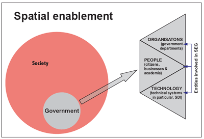
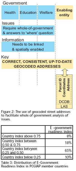
The United Nations notes, in its most recent E-Government Survey, that a trend towards reforming the public sector has emerged in many countries in recent years spurred primarily by the aspirations of citizens around the world. These clients of government are demanding top performance and effi ciency, proper accountability and public trust, and a renewed focus on delivering better service and results. To accomplish this transformation governments are introducing innovations in their organisational structure, practices, capacities, and in the ways they utilise human capital, information and communication technology (ICT) and fi nancial resources in service delivery to citizens. The real benefi t of E-Government, in the view of the United Nations, lies not in the use of technology per se but in its application to processes of transformation of government and society.In the developed world the E-Government agenda is most often less about changing the nature of democracy and more about improving the business of government via better customer relations. In contrast, much of the focus in developing countries has been on leveraging E-Government as a means to overcome traditional governance weaknesses, notably an absence of openness, excessive corruption and weak accountability to citizenries as a result. At the same time as progress is being made in E-Government implementation, the spatial community has been developing ways of deploying spatial enabling platforms across government to facilitate better government outcomes. This phenomenon is being referred to as the Spatial Enablement of Government, a component of a much broader trend, the Spatial Enablement of Society. The relationship between Spatial Enablement of Government and Spatial Enablement of Society is depicted in Figure 1. A basic requirement for effective spatial enablement is the availability of geocodes. A geocode normally takes the form of a geographical coordinate, that is, the latitude, longitude and (sometimes) height of a point. Geocodes derived from cadastral and land administration systems are ideal for the purposes of spatial enablement because the source databases of land parcels and road corridors, street addresses and interests in land have integrity, are authoritative, are kept upto- date and are linked to a map base and a country’s geodetic reference system. Geocoded street addresses are perhaps the most useful derivative of cadastral and land administration systems in terms of Spatial Enablement of Government because street addresses are one of the most common elements in government databases. Geocodes provide the means of linking information held in databases in different organs of government, thus allowing the analysis of issues on a whole of government basis. The ability to assess issues on a whole of government basis is crucial for governments to be able to effectively respond to contemporary global challenges such as sustainable development, clean water, population and resources, democratisation, global convergence of information technology, the richpoor gap, health issues, peace and confl ict, the status of women, and transnational organised crime. The E-Government readiness indexThe United Nations E-Government Survey provides a comparative assessment of the application of ICT by governments of the 192 United Nations Member States. The fourth global Survey was undertaken in 2008. The Survey seeks to provide governments with a measuring tool that shows their respective areas of strengths and weaknesses within the E-Government Readiness domain. Member States are at different phases of delivering E-Government services. Some of the developed countries are beginning to migrate beyond E-Government to I-Government (or Connected Government) (The Government of Singapore describes I-Government as Integrated Government) which provides the basis for the transformation from a bureaucratic government to a people-centred one. Some States are in the transactional phase of E-Government and still other States are at the initial phase of E-Government where very few services are delivered online. The conceptual framework of the E-Government Survey is based on a holistic view of development that incorporates human capacity, infrastructure development and access to information and knowledge. The overall results of the Survey for each country are presented as a single number, the E-Government Readiness Index. This is a composite index comprising a Web Measure Index, Telecommunication Infrastructure Index and Human Capital Index. As countries move upwards towards the stage of Connected Government they pass through fi ve stages – emerging, enhanced, interactive, transactional and connected. The Web Measure Index provides Member States with a comparative ranking on their ability to deliver online services to their citizens. The Telecommunication Infrastructure Index is a composite index of fi ve primary indices relating to a country’s infrastructure capacity as they relate to the delivery of E-Government services. These are: Internet users /100 persons; PCs /100 persons; main telephones lines /100 persons; cellular telephones /100 persons and broad banding /100 persons. The Human Capital Index is a composite of the adult literacy rate and the combined primary, secondary and tertiary gross enrollment ratio. Characteristics of countries with a high E-Government readiness indexThe Survey provides an insight into the characteristics of E-Government in countries with a high E-Government Readiness Index. In these countries E-Government is being viewed as an enabler of organisational and democratic renewal rather than primarily a costsavings technique. There is a move from static websites to integrative portals where the perspective of government operations is based less on organisational charts and more on citizen usage and outcomes, and where integrated service offerings hide, simplify or transcend the traditional machinery of government. There is also greater centralisation of ICT management and functions, and a strong emphasis on collaboration across sectors to create networked government. The view of electronic and digital systems is changing back offi ce support functions to a strategic and enabling architecture for most aspects of organisational performance. Figure 1: The relationship between Spatial Enablement of Government and Spatial Enablement of Society Countries with a high E-Government Readiness Index are creating an information infrastructure both within the public sector and across society at large based upon reliable and affordable Internet connectivity for citizens, businesses and all stakeholders in a given jurisdiction. The new infrastructure is being leveraged within the public sector in order to better share information and bundle, integrate and deliver services through more effi cient and citizen-centric governance models encompassing multiple delivery channels. There is a fostering of inter-jurisdictional partnering to the end that national reforms are being shaped by innovations emanating from the fl exibility and nimbleness of smaller, sub-national governments. One of the most important lessons to be derived from the experiences of developed countries, the 2008 United Nations E-Government Survey notes, is the importance of collaboration between governments, that is, adopting federalism as a key design principle. Even in unitary government systems, where central governments can more easily impose decisions on other, ‘subordinate’ public sector levels, leading E-Government countries have demonstrated that collaboration provides a better path. In more formal federalist structures, collaboration is essential in overcoming constitutional and jurisdictional boundaries that are not so different than borders between countries. The lesson here is that in a federated architecture model where power and decision-making authority must be shared across different governance layers, the willingness and the ability to collaborate are essential for positive transformation to occur. E-Government readiness in Asia and the PacificThe 2008 E-Government Readiness Index for countries who are members of the Permanent Committee on GIS Infrastructure for Asia and the Pacifi c (PCGIAP) is shown in Tables 1, 2 and 3. PCGIAP members are the countries recognised as being members of the United Nations Economic and Social Commission for Asia and the Pacifi c. There is a large variation in the E-Government Readiness Index of countries. At one end of the scale 6 countries are in the top 35 globally and 2 of these are in the top 10. However most (75%) countries have an index below 0.5 and the average index for the region is no different to the global average of 0.45. These fi gures indicate that, from an Asia and Pacifi c perspective, E-Government needs will be different from country to country and strategies will need to be assessed on a case by case basis. Geocodes and E-Government readinessThe effective implementation of E-Government in a country requires a whole of government approach, that is, all the organs of government working towards the common strategic objective of E-Government. In Australia, which has a relatively high E-Government Readiness Index, spatial enabling platforms are being deployed in government at national and sub-national levels as a means of supporting better decisionmaking in government and more effi cient government operations, and to support the implementation of E-Government. Examples of these spatial enabling platforms are the Commonwealth Spatial Data Integration initiative, the Western Australia State Land Information Platform, the Victorian VICMAP infrastructure, the New South Wales Common Spatial Information Initiative, and the Northern Territory Land Information System. Work has also started on a Trans- Tasman initiative called the Australia New Zealand Spatial Infrastructure. In each of these cases geocoded street addresses derived from government cadastral and land administration systems is playing a key role in the spatial enabling platforms. Australia is fortunate in possessing a national authoritative complete and up-to-date list of geocoded street addresses called the Geocoded National Address File (GNAF). GNAF is produced by a government-owned company, PSMA Australia Limited. GNAF is a reference dataset used in government, business and the community. The way in which geocoded street addresses allow whole of government analysis of issues in Australia is depicted in Figure 2. Most of the countries of the world, however, are not as fortunate as Australia in this regard. They do not have ready access to country-wide digital geocodes of any form let alone a national geocoded street address database linked to cadastral parcels. In some cases political considerations such as national security prevent access to geocodes even if they do exist. The lack of availability of geocodes presents a signifi cant technological hurdle to the achievement of spatially enabled government. As a minimum this technical challenge requires research into new and effi cient ways of generating country-wide geocodes. Notwithstanding this problem, cadastral organisations around the globe, and the geocodes embedded in their cadastral parcel databases, provide a key to effective deployment of spatial enabling platforms in government, and the key to improving E-Government Readiness in countries. In many cases this requires cadastral organisations to change the way they do their business. For example, they need to consider establishing and maintaining digital cadastral databases. These databases need to be visible and accessible, preferable on the Internet, in a way that is meaningful to users. Unique geocodes need to be generated for each digital cadastral parcel and where possible these geocodes applied to the street address of the parcel. These basic measures could be supplemented by cadastral organisations providing geocoding training and services to government agencies that would allow agencies to validate and geocode their own digital databases. Further, cadastral organisations could facilitate partnerships between government agencies with the objective of integrating their web portals using geocodes as the linking mechanism. By taking these actions cadastral organisations could become more strategically relevant to their government. |
||||||||||||||||||||||||||||
|
||||||||||||||||||||||||||||
|


 (93 votes, average: 1.34 out of 5)


Leave your response!