| Geodesy | |
Determination of local gravimetric geoid
|
||||
|
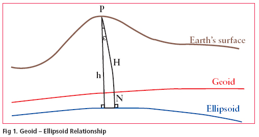
The demand for a high resolution geoid model has grown substantially during the last few decades especially after inception of Global Positioning System (GPS). Many countries across the world have already developed their own geoidal model which serve as the means of deriving orthometric heights from GPS observations. The impact of GPS on surveying application is undeniable. More so, this revolution has not been confi ned to the surveying community, but has extended into mapping, navigation and Geographic information system (GIS) areas. During the last few years, we have been witnessing the wide spread adoption of GPS with an equivalently vibrant range of accuracy requirement. Many of these applications require accurate vertical positions. The task of transforming the ellipsoidal height obtained from GPS technique to the orthometric height has prompted geodesists around the world to determine the high precision geoid undulations, for their region of interest. In India the present day nation wide geoid was computed a long time back and based on astro geodetic observations with respect to Everest spheroid. It has various limitations and does not have any signifi cance as far as GPS solutions for orthometric height is concerned. Present study was taken up to validate the results of orthometrc heights derivation in a pilot project of large scale mapping of a part of Delhi through Airborne Laser Terrain Mapping(ALTM) Technique. A fairly dense gravity anomaly data consisting of about 160 uniformly distributed points covering a block of 1° X 1° including National Capital Region(NCR) of Delhi was used in the geoidal modelling process .The study was aimed at to analyse approach of data preparation and treatment procedures and a evaluation of test results obtained from the analytical solution of Stokes’ integral with appropriate Kernel modifi cations. Gravimetric Geoid and GPSThe geoid can be broadly defi ned an equipotential surface of Earth’s gravity fi eld that closely approximates with mean sea level (MSL) neglecting long term effect of sea surface topography (SST). The fundamental relationship between the geoid and The geoid undulations (N) may be computed in a simple manner by doing GPS observations in order to determine the ellipsoidal heights at all levelling bench marks. However if heights of some other points is required to be given it may not be possible to extrapolate the GPS- levelling heights differences. In this case gravimetric information may be used to bridge the gap through determination of local gravimetric geoid. In a broad sense geoidal surface is that undulating surface along which the potential remains the same.The undulations of the geoid are not the same as, but are affected by the variations in topography. Because of this complexity, high resolution gravimetric geoid models and associated interpolations software have been developed to support GPS height conversion. |
||||


 (No Ratings Yet)


