| Applications | |
The vulnerabilities and challenges of Caribbean SIDS
The vulnerabilities of Caribbean Small Island Developing States (SIDS) can be addressed by responsible land governance |
 |
|
Small Island Developing States (SIDS) globally possess characteristics that render them vulnerable to greater impacts of economic, social and environmental shock than other countries. These characteristics include their small size, and limited useable space, economic dependence on international markets, and vulnerability to climate change impacts, particularly sea level rise. Caribbean SIDS face even greater challenges as a result of their particular features that are additional to the ones listed above. The limitations of useable space are further exacerbated in Caribbean SIDS by the volcanic geomorphology of many of the islands. Most of the islands have very narrow coastal areas suitable for occupation and use, and steeply rising interiors. In most instances, the population has no choice but to occupy these precarious slopes resulting in a situation where both the occupants of the slopes and the downstream communities become susceptible to landslides and floods. In addition, some segments of the population experience insecurity of tenure resulting from the large percentage of informal tenure occurring on either squatted land or communal family land. This informality and insecurity affect disaster management as recovery, redevelopment, and reinstatement of land tenure is rendered difficult post-disaster, particularly since hurricane and storm effects are becoming more prevalent with climate change.
The recent Habitat III declaration of an Urban Agenda means that the Caribbean must focus more on how the urban environment can be empowered through improved land governance models to provide growth and development for the Caribbean SIDS and their societies. Improved land governance can address some of the land related vulnerabilities by providing mechanisms for supporting adaptation to hazards and risks and by building resilience. Lessons for land governance that can be applied in Caribbean SIDS can be learnt from recent outcomes of discussions on SIDS.
In the face of the challenges that SIDS encounter, and given the need to respond by utilising land governance mechanisms, land professionals and landbased organisations in the Caribbean must, therefore, question their standard approaches to land management and the supporting land administration, and be willing to modify and adapt their frameworks to fit within the particular characteristics of the Caribbean, taking into consideration the specific needs of Caribbean SIDS. Land professionals and land-based organisations are best placed to build awareness among the populations, of land governance tools such as the FAO’s Voluntary Guidelines on the Responsible Governance of Tenure (VGGT) and FIG’s Fit-for-Purpose approaches and how they can be adapted to apply to the specific environments within each country.
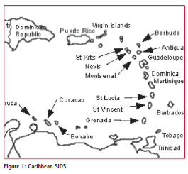
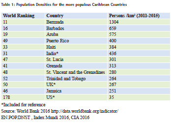
Caribbean SIDS, illustrated in spatial relationship in Figure 1, require special attention if the region is to meet development goals and achievements set out in the recently declared Habitat III Urban Agenda that focus on achieving safe, equitably-allocated rights to land in sustainable urban settlements. The Caribbean is not urbanising as quickly as the rest of the world nor Latin America (UNHabitat 2012). World Bank (2009) figures put the percentages of populations living in the urban environment at 84.3% for Brazil, and 65% for Panama as opposed to 32% for Barbados and 9% for Trinidad and Tobago. Other definitions of the term ‘urban’ that include agglomerations or densely populated periurban areas, however, put the urbanisation figures as far higher than those stated since population densities outside of strict definitions of city boundaries are high for some Caribbean countries, as shown in Table 1, (World Bank 2016) and it is difficult to make a clear distinction between urban and suburban or even rural. The issues surrounding urbanisation, therefore, still significantly affect the countries of the region. This paper sets out the vulnerabilities present in Caribbean SIDS and suggests ways that the land based professionals and groups can play a role in advancing the application of tools that can address the existing challenges through improving land governance.
Background
The Caribbean comprises several island or archipelagic island groupings between Florida to the north and Venezuela on the South American mainland to the south, scattered over thousands of square kilometres of marine space. The countries have formed themselves into several political groupings and organisations, such as CARICOM and the OECS, some of which include the mainland territories of Guyana and Suriname (CARICOM). The total land area of all islands in the region is approximately 240,000 km2 with island territories ranging in area from 91km2 (Anguilla) to 105,806km2 (Cuba). Most of these are considered to be SIDS. Caribbean SIDS share with other SIDS the challenges of small size, remoteness, dense populations, economies dependent on developed countries, restricted markets, limited resources, physical vulnerabilities to natural disasters intensified by climate change, intensely competing and conflicting land use, high cost of public service provision and low capacity in the public service. Some of these are intensified in the Caribbean. The economies of the countries, for example, have been ravaged by the 2009 global financial crisis which caused a 9.2% drop in tourism and a 21.9% decline in foreign investments in construction leading to a reduction in GDP by 5.7% (World Bank 2011).
There are also land related traits in the Caribbean that are distinctive to the region. These are primarily: the physical structure of some of the islands that demands that occupation be concentrated in the coastal areas, a shared history of colonisation that has left disparities in access to land that still persist, the presence of the informal communal tenure of family land, and the high incidence of spontaneous occupation on both state and private land. These conditions increase the vulnerability of the societies in the Caribbean. Improved land governance can ameliorate the impacts that these circumstances have on the well-being of the societies and the opportunities for equitable growth and sustainable development.
Vulnerabilities of Caribbean SIDS
Many of the Caribbean countries are volcanic in geomorphology with steep internal slopes and narrow flat coastal areas where most of the built development occurs. This puts a large part of the population and the built construction at risk of inundation and storm surges. Increasing built development in the elevated areas also intensifies the risk of landslides and floods as built development can weaken soil by removing protective grass, shrub, and tree coverage and allowing liquid infiltration. Built development can also increase rainfall runoff speeds and volumes by adding to the area of impervious surfaces, leading to flooding in lower areas. Land sector agencies and land professionals should seek innovative ways of encouraging development that include risk mitigation at higher elevation and low lying regions while attempting to preserve the environment, the built development, and the society from physical harm. There is usually insufficient available space to completely exclude all hazardous areas from construction and other use. The coastal areas where activity and occupation are concentrated, are low-lying with a significant proportion of the areas below 5 metres above sea level. Investments in infrastructure and tourism related development have also been rendered prone to loss as a result of hazard events.
The large percentages of informal tenure adds to the vulnerability of the affected communities. There are significant linkages between security of land tenure and the ability of the land occupants to recover from natural disaster (FAO 2011; Barnes and Riverstone 2008; Griffith- Charles et al. 2015). The annual hurricane season in the Caribbean usually results in significant damage and destruction but this is periodically, and increasingly more extensive and devastating. Climate change is causing variations in weather patterns that are intensifying impacts and increasing the frequency of particularly destruction storms. When these occur, informal communities lose lives, and livelihoods and find difficulty recovering (Huq and Ayers 2007, Herianto et al. 2007).
Vulnerabilities of urbanisation
Since most urban development is already in the vulnerable coastal zone, any increase in urbanisation puts a greater percentage of the population and a larger part of the economy at risk for damage or loss. The sprawling urban agglomerations of the islands cannot evade this risk as there are limited alternatives for occupation and use. The risk must instead be documented, quantified, and managed as part of an optimised land governance framework.
Urbanisation can also increase the incidence of poverty, inequity of access to livelihoods, land and resources, crime, and conflict. These issues put stress on the ability of the underresourced land management institutions to address them. The land administration systems cannot keep pace with the growth in the urbanising environment and lack basic information on social and tenure dimensions leading to under informed decision making.
Constraints to improved land governance
Improving land governance requires principled approaches as well as attitudinal change but also tangible institutional structures that are costly to establish and maintain. Fragile and weakening economies in an era of global economic recession can ill afford the establishment and maintenance of high technology information systems, and land administration systems. These systems are, however, vital to the support of responsible land governance. Some of the fundamental principles of transparency and inclusion that ground current theories of responsible land governance may be alien and unfamiliar to many traditional societies including those in the Caribbean that can be community and family oriented and somewhat insular. Publicly displaying land title information can be resisted in these societies.
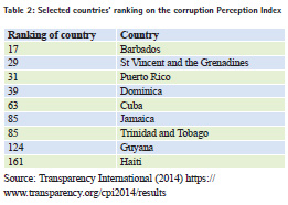
Some of the few countries in the Caribbean that are assessed in Transparency International’s Corruption Perceptions Index, fall low on the scale as shown in Table 2. Since this ranking identifies perceptions about state institutions, it reflects the functioning of the land based institutions and the frustration that persons accessing the land institutions face. It is often thought that accessing services such as land transactions for registration, planning approval, valuations for compulsory acquisition all require the offer of bribes to have the service be sped up or done at all.
There is need for documented and implementable land policy derived from inclusion, and transparency, supported by rich current land information and continuously revised and maintained on the basis of monitored indicators of intervention success. This requires economic and human resources with capacity in the state institutions. In addition to addressing all the vulnerabilities pertinent to the region, this land policy should provide the framework for and support the development of institutional structures that focus on urban land management.
Tools for improved governance
Current land governance tools including those that provide custom built technology promise low cost, efficient and effective systems that can address resource gaps to improved land management. Despite the absence of documentary security of tenure promised by formal titling, many persons in informal settlements or informal holdings on family land in the Caribbean feel a strong sense of tenure security borne of cultural acceptance, community acknowledgement and the states’ indulgent attitudes toward informality. Many enjoy access to basic utilities of electricity and water. The incentive of joining the land market through formal titling holds little attraction to homeowners of low value property and credit institutions will seldom see these properties as marketable or fungible even if they were titled. The settlements do not conform to planning and construction standards and are in marginalised land in locations exposed to environmental hazard impacts. Regularisation of planning standards and formal titling projects to regularise tenure do not always provide the solutions to poverty and powerlessness nor do they establish or invigorate a comprehensive land market in stagnant economies (Deininger, et al. 2003, Sanjak 2012; Griffith-Charles 2004; Barnes and Griffith- Charles 2007). Titling and/or recording of tenure can however provide variegated solutions for different segments of the land market. Titling in enclaves of higher valued properties can serve to invigorate land markets. Recording of informal tenure in their communities can have the imperative of providing security of tenure but also providing for the well-being of marginalised members of the society.
Capacity building for improved governance
The land management institutions of the Caribbean, mindful of challenges to availability of land, do not have the power or the will to strictly enforce planning codes and building restrictions and often prefer to offer the occupant options for building that would minimise the impact even in high-risk areas. In other instances they may turn a blind eye to breaches. The countries are densely populated with limited land space yet densifying occupation with high rise dwellings is not a popular option for addressing land allocation and access. Cultural norms and ingrained habits need to be managed. Public awareness is required to introduce populations to the ease of current methods and thinking. Governance does not only take place at the level of government or state institutions. Civil society plays a fundamental role in governance and therefore, communities and community leaders must accept their responsibilities to the society. Establishing, populating and maintaining land administration systems for informal sectors is a way for civil society to engage with the activity of governance.
The Voluntary Guidelines for Responsible Governance of Tenure suggests that land administration systems should be provided and that these be transparent and accessible but while systems are available in most cases these characteristics are not available in the under-resourced land sector agencies of the Caribbean. Land administration system reforms are often project based and externally funded and designed to use high cost and rigid technological solutions that cannot be maintained after establishment. Adherence to historical bureaucratic regulations in the land administration affects the accessibility of information and the responsiveness to changes in the social and environmental structures in the countries in reaction to global fluctuations. For valuation surveying, for example, the VGGTs advise that information systems on values should be provided and that such information take into consideration non-market values such as social, cultural, religious, spiritual and environmental values. Apart from the lack of resources, and capacity in the institutions to adopt this recommendation, professionals and public officers resist the introduction of new approaches.
Professional and organisational collaboration
Professionals, including those whose disciplines are land related, often feel impelled by their learning to uphold rigid and precise systems. Lawyers demand the continuation of formal titling systems with strict specifications of a few narrow bands of tenure type of freehold, leasehold, and licence. Land surveyors claim the need for precise fixed coordinate systems for physically defining boundaries of land rights. If these land based professionals are to embrace their new role of supporting more flexible systems of operation that are fit for purpose, and that value social benefits over technological advancement, then capacities must be built first of all at this level. Professional and organisation collaboration can result in cross cutting interchanges that can deepen and broaden the understanding of impacts and outcomes of the application of innovative methodologies. Collaborations can also assist in funding practical research and meaningful application of proven tools in underserved and marginalised communities. This is also a way of the land professionals providing inputs to responsible governance.
Conclusion
Land administration systems have seen an expanding role and responsibility over the years and have come from merely recording taxes or title to where they now are a vital component of a land governance system. Similarly, land professionals are now seeing an expanded role from performing the technical aspects of their disciplines and serving their immediate clients to the best of their abilities to now being agents of change in the achievement of larger, more principled societal goals. Land professionals can rise to this challenge by keeping informed of how innovative land tools can be and have been applied to be more effective at attaining overarching social, economic, and environmental goals of the society. They can then provide dissemination roles to their publics, their land governance institutions and their professional groups but beyond this must take part in research and discussion on efficacies of various tools. Blinkered focus on technical issues can no longer be accepted.
References
Barnes, G., and C. Griffith-Charles. 2007. Assessing the Formal Land Market and Deformalization of Property in St. Lucia. Land Use Policy. Vol. 24:2. Pp494-501.
Barnes, G. and J. Riverstone. 2008. Postdisaster Land Issues Case Study: Hurricane Ivan (2004) in Grenada. Final Report.
Deininger, K. 2003. Land Policies for Growth and Poverty Reduction: A World Bank Policy Research Review. Oxford University Press FAO. 2011. Manual 3 “Assessing and responding to land tenure issues in disaster risk management”. FAO: Rome Griffith-Charles, C. 2010. Good Governance and Natural Resources in the Caribbean Subregion. Land Tenure working Paper 17.
Griffith-Charles, C., 2004. The impact of land titling on land transaction activity and registration system sustainability: a case study of St. Lucia. Ph.D. Dissertation, Geomatics Program, University of Florida.
Herianto, A., Suparta, I., Pranasari, M., Chessy, V., Arief, F., and P. Yudono. 2007. An Assessment of People’s Livelihoods in Yogyakarta and Central Java Provinces Pre- and Post-Disaster: July- November 2006. Project TCP/INS/3101 (E). Jakarta, Supported by the FAO.
Huq, S. and J. Ayers. 2007. Climate Change Impacts and Responses in Bangladesh. European Parliament’s Temporary Committee on Climate Change: London.
Sanjak, J. 2012. Land Titling and Credit Access (USAID Issue Brief). USAID. UNHabitat 2012 State of Latin American and Caribbean Cities: Towards a New Urban Transition. UNHabitat: Nairobi.
World Bank. 2016.
The World Bank. 2011. OECS Country Brief 2011.
http://go.worldbank.org/37LLRJ7R10.
World Bank. 2009. World Development Report 2009: Reshaping Economic Geography. Washington, D.C., World Bank. Index Mundi. 2016. http://www. indexmundi.com/g/r.aspx?v=21000
Central Intelligence Agency (CIA). 2016. World Factbook. CIA
This paper was slightly modified from a paper presented at the SIDS Workshop of the FIG Working Week 2016, Christchurch, New Zealand 2-6 May 2016


 (1 votes, average: 3.00 out of 5)


Leave your response!