| Surveying | |
Low cost GNSS and Geo-referencing
This paper presents challenges faced by surveyors in Jamaica to geo-reference small rural cadastral surveys. An interim solution to the problem is provided. We present here the second part of the paper. Part 1 was published in the September 2017 issue |
 |
|
 |
|
 |
|
 |
|
 |
|
Methodology
This study falls in the category of Applied Research, as it seeks to answer the question as to whether low cost GNSS receivers can be used to georeference small rural surveys. The methodology applied is quantitative, since the data collected is numerical and is used to produce statistical analyses.
Data Collection
Data was collected in both Autonomous and Static modes on known stations in the National Calibration Network of Jamaica, located at Heroes Park in Kingston. In autonomous mode, coordinates were recorded every five minutes (5mins) for at least thirty minutes (30mins).
The hand held receiver, was placed over the first station, and the coordinates recorded. It was then moved to the second station where the coordinates were recorded instantly and then allowed to log data for five minutes before a second set of coordinates was recorded. It was then moved back to the first station where the coordinates were recorded instantly.
After that the receiver was left alone for five more minutes before the coordinates were recorded again before taking it back to the second station to record the newly generated set of coordinates. For each set of coordinates that were recorded, the time of the recording was also noted. In static mode, the GPS receiver was centered over the mark for between twenty (20) and forty-five (45) minutes while data was being logged.
Data Processing
The Most Probable Value (MPV) and Standard Deviation (SD) of the coordinates were computed using the autonomous data, while the relevant proprietary GNSS software was used to perform the data processing and adjustment for the static data collected with each receiver. The coordinate and vector differences were then compared with the respective known points and lines.
Results
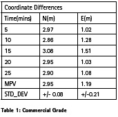
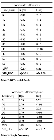
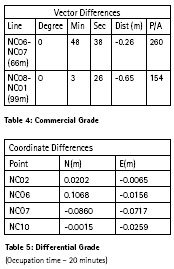
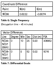
When the various receivers were used in Autonomous Mode the coordinate differences with reference to a known calibration point are as set out in the tables 1-3, while the vector differences for two (2) lines using a differential grade receiver are given in table 4.
When two of the receivers are used in Static Mode with an External Antenna, the coordinate differences after post processing with reference to a known VRS Station are as set out in the tables 5 and 6, while the orientation differences using differential grade are shown in table 7:
Analysis
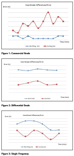
Graphic displays of the coordinate differences or error, when the receivers are used in Autonomous Mode, are given in figures 1-3
The coordinate differences or error returned by the commercial grade receivers displays erratic behavior in the northing component, but a consistent sub 2m difference in the easting. For the purposes of the new regulations, such a receiver would be considered inaccurate by virtue of section 35D, subsection 3 of the Land Surveyors Act. A close examination of the data recorded in table 1, reveals that there are at least two outliers (10 m and 8 m). Should these be rejected, the standard deviation would be reduced to less than 2m. This would suggest that the average coordinate computed from the remainder of the dataset has a mean distribution (precision) of less than ±2m around that mean/MPV. However, what is of greater significance to the Land Surveyors Act, is that the instrument is capable of delivering a result within ±3 m of the true value i.e. accuracy. Even at a precision better than ±2 m, the accuracy is worse (+/- 0.88m, +/- 4.38m) than ±3 m in this case. However, the result of any GNSS survey is a function of conditions of the site, occupation time and most importantly the state of the constellation (PDOP) at the time of observation. It must also be borne in mind that the commercial grade and indeed some differential grade receivers may be GPS only.
Both the differential grade and the single frequency receivers deliver sub 3 m coordinate differences in autonomous mode, which suggest that they are ideally suited to geo-reference small rural cadastral surveys, in this mode based on the temporary exemption. However, it is the orientation of the survey which is a cause of concern given the 49’ difference on a 66m line, since the directive requires that the North arrow be labeled Grid North. With antennas attached or engaged, both deliver sub 10cm coordinate differences (Tables 5 and 6) and less than 11’ difference in orientation using post processed static data. This result supports the use of these receivers for geo-referencing not only rural surveys but also urban surveys.
Recommendations
Consideration should be given to the fact that single frequency receivers are limited in range by between 10 to 15km, and given the spacing of the VRS stations, not all locations would be within this range of a VRS station. Outside of this range, surveyors would need to have a second receiver for occupation of a nearby (within 15km) SMD_NLA ground control, which would work counter to the issue of cost. What is of concern to many surveyors is the need to do this for the majority of their rural surveys in very remote areas which are less than 2000 sq. m. where the basic cost of the survey is already a strain on their clients’ meager budget. One thinking is that Surveyors should be allowed to use commercial grade GNSS on deep rural parcels less than 2 hectares.
The new regulations require that surveyors submit a completed reporting form, indicating the method of fixing the points and the quality of the coordinates submitted. In the case of autonomous occupations, it is therefore recommended that the points be occupied for a minimum of 45 minutes, in the form set out in table 1. This would allow for adequate redundancy and therefore the rejection of outliers for the purposes of computing an acceptable mean/mpv. The mean/mpv and standard deviation of the two (2) points occupied should be written on the plan.
Occupation should only be after proper mission planning is done to ascertain the predicted GPS/GNSS conditions at the site and therefore the best time to observe these coordinates. Of course the site selected must be the two best locations/stations, even if one has to be auxiliary (longest possible line) to the traverse being used to carry out the survey. Also, if surveyors will be allowed to use commercial grade receivers, unless there is evidence of marked improvement in their performance, say for example, they are GNSS and outputting sub 3 m in typical condition, their use should be a temporary measure, allowing surveyors adequate time to upgrade to at least differential receivers. This is principally because deriving the orientation of the survey from ±3 m coordinates results in a very weak determination of this component of the vector. While this continues to be the case surveyors are now required to place a note on their plan to say that: “The accuracy of the orientation is commensurate to that of the standard deviation of coordinates of the boundary points.”
Conclusion
All provisions for the use of low cost receivers for georeferencing surveys in the rural areas will only apply where the survey falls outside the range of 400 m of a pair of SMD_NLA ground control or where VRS is not available. They are therefore expected to be temporary. While this continues to be the case and commercial grade receivers are used, we urge extreme care in arriving at the best solution for the mpv of the stations’ coordinates by observing all best practices of GNSS surveys to obtain a standard deviation of less than ±2m. Differential grade and single frequency receivers have demonstrated that they are the better options suited for this task, if cost is a factor, and the surveyor does not envision his/her need to acquire dual frequency GNSS receivers, which would be at a cost outside of their budget.
References
[1] Garmin. Garmin. n.d. www8.garmin.com
[2] Hofmann-Wellenhof, B, H Lichtenegger, and E. Wasle. GNSS–global navigation satellite systems: GPS, GLONASS, Galileo, and more. Springer Science & Business Media., 2007.
[3] Land Surveyors Board Jamaica. "Land Surveyors Regulations." Kingston: Government of Jamaica, 1971.
[4] Land Surveyors Board of Jamaica. "Land Surveyors (Amendment) Regulations ." Land Surveyors (Amendment) Regulations. Land Surveyors Board of Jamaica, 2013.
[5] "Land Surveyors Act." Kingston: Government of Jamaica, 2005.
[6] Magellan. Magellan GPS. n.d. www.highspeedsat.com
[7] Office of the Cheif Surveyor General South Africa. Cheif Surveyor General. n.d. http://csg.dla.gov.za/cadsurv.htm.
[8] Schwieger, V. High-Sensitivity GPS – the Low Cost Future of GNSS. Hong Kong, SAR.: FIG, 2007.
[9] Scott, B., Jones, R., and James, K. The implications of the recent amendments to the Land Surveyors Regulations of Jamaica. University of Technology, Jamaica – Final Year Research Project, 2016.
[10] Spectra Precision. Spectra Precision. n.d. www.spectraprecision.com/ eng/promark-120.html.
[11] Trimble. Trimble. n.d. www.trimble. com/Survey/trimbleGeoXRgnss.aspx (accessed February 24, 2015).


 (No Ratings Yet)


Leave your response!