| Applications | |
Landslide vulnerability
|
||||||||||||||||||||||||||||||||||||||||||||||
|
Landslide is a common hazard in the hilly regions which causes heavy losses to life and properties every year. Since 1980 various researches and analyses have been carried out in the GIS environment to identify factors responsible for causing landslides. The important conditioning factors identified by the researchers are slope, geological, geomorphologic structures and land use coupled with triggering factors like rainfall and a few of the anthropogenic activities. Soil forms the upper most part of he earth crust and it is expected that the various soil characteristics like depth, surface texture, depth texture, soil erosion, hydraulic conductivity, stoniness etc. play significant role in causing landslide in an area. This technical paper is an attempt to study in depth the various soil characteristics that may increase the landslide. Landslide has been a perennial problem of the hills and various models have been designed for landslide vulnerabilities (Jibson et al, 2000; Luzi et al,2000; Zhou et al 2002; Carro et al 2003, Lee 2007, Burrough and McDonnel, 1998, Miles et al. 1999, Siddle et al 1991, Lee et al 1991, Hutchinson and Chandler 1991, Hutchinson et al 1991, Morgan et al 1992, Carrara et al 1991and 1992, Moon et al 1992,Wadge 1988, Gupta and Joshi 1990, Wang Shu-Quiang and Unwin 1992, Pachauri and Pant 1992,) .This study makes a detail study of the importance of various soil parameters with respect to their influence on slope instability and landslide vulnerability. The study area for this investigation is Sang Revenue Circle in east district of Sikkim, India and includes 15 (Fifteen) revenue villages. The area extends from east longitude 88o 26’ 40.17” to 88o 33’ 42.35” and North Latitude of 27o 13’48.85” to 27o17’22.24” covering an area of around 40 square kilometers. Since 1968 there is a prominent landslide at Sirwani Revenue Village that blocks the road between Singtam and Sirwani every year during the monsoon season. The data used for the study has been sourced from various agencies including, NIC-GIS/NBSS&LUP, NRSA, Rural Management Dev. Department, Govt. of Sikkim, and Wikipamia.
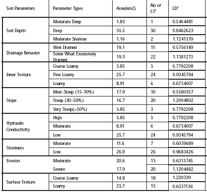
MethodologyThe spatial data required for this study was acquired from the National Informatics Centre, Sikkim State unit’s Spatial Data Bank. Soil maps were in shape file format with related attributes. Soil has eight different characteristics namely depth, inner texture, surface texture, erosion, slope, stoniness, drainage and hydraulic conductivity. Each of these parameters have been categorized into 3 to 5 types by assigning different weights with respect to stability and landslide susceptibility based on experts opinion and the common logic. Each of such parameter categories are assessed with respect to common logic and experts’ opinion on one side and on the basis of evidence of their behavior with respect to landslide events on the other. Important Soil Characteristics ConsideredDepth
Depth of the soil forms one of the important factors for assessing the stability of the soil and landslide susceptibility of the land. With the increase of soil depth, the tendency of soil to absorb moisture is increased, resulting in reduced runoff rate. Hence shallow soil is considered to be more unstable and prone to landslide than the deep soil. Soil Texture The texture of soil represents the relative proportion of sand, silt and clay content. Soils with high percentage of clay form very stable aggregate resistant to detachment. On the other hand, light soils like sandy or coarse loams are easy to detach as they have low organic matter content (Das and Agarwal, 2002). Hence, soil with more sand, high slope and intensive rainfall which constitute most dominant factors of landslide cause severe damage to land (Patanakanog, 2001) .
Surface Texture The texture on the surface of the soil may be different from the texture found below the surface. Erosion One of the principal reasons for landslide is the progressive deterioration of soil due to erosion. Soil erosion is the detachment and transportation of soil material from one place to another through the action of wind, water in motion or by the beating action of the rain drops. It is the outcome of many factors in combination that include the intensity of rains, porosity of soil, physical as well as chemical properties of rock. The slope of the land has direct relation to the soil erosion because soil erosion due to run-off is more on sloping and denuded lands (Samra and Sharma, 2002). As a result, the rate of soil erosion is very high in such areas where the soil is mostly sandy in nature, slope is high and rainfall is frequent. Thus, with the increase of soil erosion, the susceptibility of an area to landslide also increases. Soil is characterized by either severe erosion, moderate erosion or low erosion. Stoniness
Soil stoniness is also an important characteristic of soil which influences the intensity of landslide. It refers to the proportion of stones (or rocks) within a unit volume of soil or on its surface. Stones left in place may provide for soil and water conservation by protecting the surface against raindrop impact or retarding water flow along the surface. Therefore, soils with more stones (or rocks) are less prone to the landslide as compared to that of soil with less stones.
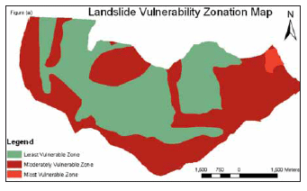
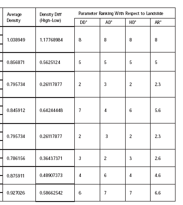
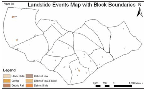
Slope The degree and length of slope determine the amount of runoff and extent of soil erosion. As water flows down the slope, it accelerates under the force of gravity. If the percent of slope is increased four times, the velocity of water flowing down is doubled. Doubling the velocity quadruples the erosive power. Sediment transport capacity of runoff increases by 10 to 100 times at one percent slope compared to 0.2 percent slope (Reddy and Reddi, 1999). More so, during monsoon season or heavy downpour, the hills get saturated with water, resulting in instability of land mass. The complete surface portion of soil may slip down from its actual position causing landslides (Wischmeier and Smith, 1978). Since the study area is characterized by steep to very steep slope along with mostly sandy soil textures, it indicates a high degree of landslide. Drainage Drainage of an area is one of the most important aspects in determining the land use pattern and landslide probability. Drainage refers to the relative rate of outflow of water to which the excess amount of water can be absorbed by the soil. Slides often occur following intense rainfall, when storm water runoff saturates soils on steep slopes or when infiltration causes a rapid rise in groundwater levels. Human action can exacerbate sliding when drainage systems fail or when development increases runoff near steep slopes (www.ecy.wa.gov/ programs/sea/landslides/help/drainage.html). Hydraulic Conductivity Hydraulic conductivity denotes the proportionality constant in Darcy’s law, which represents the amount of water that flows through a unit crosssectional area of an aquifer under a unit gradient of hydraulic head. Thus, a change in hydraulic conductivity greatly influences ground water table and slope stability. With the increase of hydraulic conductivity, the movement of water in the soil is increased. Therefore, higher the level of hydraulic conductivity of soil, higher is the probability of the landslide. The study area is classified into high, moderate and low hydraulic conductivity. Parameter Ranking Parameter ranking is done to understand which of the soil parameters considered are most influencing and which are the ones that are least influencing. This was done on the basis of landslide density in the area falling under each of the variable parameter as shown in table 1. ConclusionWe identified eight important soil characteristics to deduce eight soil parameters and listed their types from past references and assigned weight to each parameter types based on common logic and the experts’ opinion. Then based on the landslide density in the study area under each of the parameter types, three different parameters ranks based on density difference, average density and highest density were computed. Though all three type of ranks weighted almost equally, an average of them known as average rank was computed. Ranking was done in such a way that higher the rank more influencing is the parameter with respect to landslide. We deduced that soil depth is the most influencing soil parameter and the inner texture and the hydraulic conductivity to be the least influential parameters. The parameter type weights and the parameter ranks both can be used in conjunction for the study of landslide vulnerability. A landslide vulnerability map of the study area prepared on the basis of the deduced parameter is shown in figure 1 (a) where figure 1 ( b) shows the landslide events of the study area. ReferencesMichael, A.M. and Ojha, T.P. (1999) Principles of Agricultural Engineering. Ms Jain Brothers, New Delhi, India, 2, pp.586-590. Dhakal, A.S. and Sidle, R.C. (2002) Physically Based Landslide Hazard Model ‘U’ Method and Issues. EGS XXVII General Assembly, Nice, 21-26. Bianca, C.V. and Nelson, F.F. (2004) Landslide in Rio de Ianeiro: The role played by variations in soil Hydraulic Conductivity. Hydrological process. 18(4), 791-805. Brady, N.C. and Weil, R.R. (2007) The Nature and Properties of soils. Pearson Education, Inc. New Delhi, pp.756-761. Das, D.K. (2007) Introductory Soil Science. Kalyani Publishers, New Delhi, India, pp. 475-483. Sivakumar, G. L. and Mukesh, M. D. (2002) Landslide analysis in Geographic Information Systems. Department of Civil Engineering, Indian Institute of science, Bangalore. India. www.gisdevelopment.net/…/natural…/. Saro, L. (2007). Application and Verification of Fuzzy Algebraic Operators to landslide susceptibility mapping. Environmental Geology, 52, 615-623. Wischmeier, W.H. and Smith, D.D. (1978) Predicting rainfall-erosion losses-A guide to conservation planning, Agricultural Handbook No-537, US Department of Agriculture, USA. Das, D.K. and Agarwal, R.P. (2002) Physical Properties of Soil. Fundamental of Soil Science, Indian Society of Soil Science, IARI, New Delhi, India, pp. 75-77. Samra, J.S. and Sharma, U.C.(2002) Soil Erosion and Conservation. Fundamental of Soil Science, Indian Society of Soil Science, IARI, New Delhi, India, pp.162. Patanakanog, B. (2001).Landslide Hazard Potential Area in 3 Dimension by Remote Sensing and GIS Technique. Land Development Department, Thailand. (www.ecy.wa.gov/ programs/sea/landslides/help/drainage.html) Reddy, T.Y. and Reddi, H.S. (1999). Principles of Agronomy. Kalyani Publishers, New Delhi, India, pp.338. Carro, M., Amicis, M. D., Luzi, L. and Marzorati, S. (2003) The application of predictive modeling techniques to landslides induced by earthquakes: the case study of the 26 September 1997 Umbria–Marche earthquake (Italy). Engineering Geology, 69(1-2), 139-159. George, Y. L., Long, S. C. and David, W. W. (2007) Vulnerability assessment of rainfallinduced debris flows in. Department of Earth Systems and GeoInformation Sciences, College of Science, George Mason University, Fairfax, VA 22030, ETATS-UNIS. http://www. springerlink.com/content/uj26871v2831nx44) |
||||||||||||||||||||||||||||||||||||||||||||||
|
||||||||||||||||||||||||||||||||||||||||||||||


 (2 votes, average: 3.00 out of 5)


Leave your response!