| GNSS | |
Earth troposphere calibration system
|
|||||||||||||||
| For interplanetary missions, the determination of S/C state vector (position and velocity) is required both for navigation purposes and science operations. The main error sources affecting S/C tracking data are the solar corona and the interplanetary plasma, which could be removed by using the multifrequency link technique between the probe and the ground station [1]. Once solar plasma noise has been removed, the Earth troposphere remains one of the major noise sources in radiometric tracking data. At present, Earth media calibration systems are performed at NASA’s Deep Space Network (DSN) stations with different techniques, in order to reach different levels of precision due to the specific purpose of the tracking activity [2].
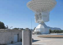
In particular, for S/C navigation, the troposphere calibration technique is based upon a combination of weather data and multidirectional, dual-frequency GPS measurements acquired at each DSN complex. At present, ESA’s Deep Space Antennas (DSA) are equipped with meteo stations, capable of measuring the atmospheric parameters and to retrieve the hydrostatic and the wet components of the Earth troposphere. With this technique a residual uncalibrated wet component is not accounted for, in an error of about 1-2% of the total tropospheric delay [2][3]. In order to avoid this, the short time-scale variations of the wet component of the Earth troposphere should be calibrated by means of water vapour radiometers or GPS measurements. A future ESA ground station media calibration systems should be at least capable to calibrate both the zenith hydrostatic path delay (ZHD) and the zenith wet path delay (ZWD) at centimeter level. The natural choice is the use of the high performance GPS receivers already installed at all ESA ground station complexes for station location purposes. Unibo software overviewA GPS data processing S/W has been developed in MATLAB® code at the Radio Science Laboratory of the University of Bologna. The main purposes of the S/W code is the estimation of the ZWD, using dual-frequency GPS observables. At present, the S/W is still just demonstration breadboard and needs accurate setup procedures in order to estimate the troposphere delay. The software has been designed using the Kalman filtering technique in order to estimate the time-varying state vector unknowns (including the ZWD). GPS observables residuals are obtained with the single and double difference techniques. The S/W architectural design is divided in four steps: Input phase, Pre-processing phase, Processing phase and Post-processing phase. Once all data are collected from the database, the Input phase starts, consisting in the translation of all input parameters which will be used in the following phases for the data analysis. The main input parameters are the GPS observables, acquired from the RINEX files and the satellite position acquired from the precise IGS database. In order to model as much as possible the errors affecting the raw GPS observables, other parameters have been included: IONEX data, Earth Rotation Parameters, station antenna phase center and satellite antenna phase center. In the preprocessing phase the stations coordinates are computed. The nominal GPS observables are combined in the so called “ionosphere-free” combination and used as the sole observable for the following phases. A preliminary estimation of the ionosphere and the dry troposphere model have been computed and combined. Finally the single and double differences for observables, ionospheric delay and dry tropospheric delay are computed. The processing phase is split in two steps. The first stage is related to the computation of the double difference of the geometric distance, starting from the already computed corrected satellite position and station coordinates. The second stage of the processing phase corresponds to the Kalman filtering process through which the unknown parameters are estimated.: the rover station positioning, the rover station ZWD and the integer phase ambiguity. Finally, once the wet delay has been obtained via the processing phase described above, the whole troposphere delay can be computed. A detailed description of the last version of the S/W code is reported in [4] where a test campaign for the validation of the results is presented too. Layout of venus express navigation testStarting from the first results obtained in [4], the S/W code developed at University of Bologna was used for a more complex test involving also the ESA-ESOC FD team. The experiment described was carried out to demonstrate the potential improvement of troposphere calibration using GPS measurements for an ESA deep space probe orbit determination test. Thanks to the non dispersive nature of the troposphere delay, the GPS-based estimation of the ZWD was used to calibrate the Doppler tracking observables of the ESA probe Venus Express (VEX), a mission launched on November 9th, 2005, currently orbiting Venus [5] and daily tracked by the ESA Deep Space Antenna (DSA) in Cebreros, Spain [6]. Among all the equipments installed in Cebreros, there is also a dual frequency GPS receiver, mainly used for station location purposes, named CEBR. The CEBR antenna and its receiver are installed about 80 m North of the DSA Figure 1.
Figure 1 Overview of the GPS antenna of CEBR with CEB DSA in background In the estimation process, the new S/W used GPS data acquired at 3 GPS reference station of the EUREF Permanent Network (EPN). These stations were considered as master stations, while CEBR was used as the rover station. The corresponding baselines between each master station and the rover station are: – ACOR-CEBR 468 km – TERU-CEBR 270 km – LAGO-CEBR 530 km Standard ESA estimation of the ZWD is obtained using surface measured temperature and relative humidity. The model used is:
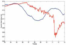
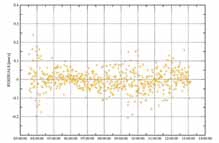
Where T is the temperature in Celsius degrees and e is the water vapour pressure in millibars. As far as the GPS S/W is concerned, the estimation of the ZWD is obtained as the output of the whole S/W process. Figure 2 shows the comparison between the estimation of the ZWD obtained with the ESA standard technique and with the GPS-based S/W. Although some points present a difference larger than 5 cm, the difference is on average within 3 cm, as expected. The troposphere estimation test was carried out using data acquired on July 4th, 2009. During that day the VEX S/C was close to “quadrature” with the Earth and the Sun. As shown in Figure 3, this means that the Sun-Probe-Earth (SPE) angle was about 90 deg. In particular, the SPE angle during the test was approximately 75 deg , meaning that the quadrature point had been reached a few days before, and that VEX was farther away from the Earth than in quadrature.
Figure 2 Comparison of the ZWD estimation between the standard ESA (red curve) and the GPS S/W (blue curve)
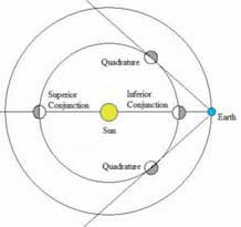
Figure 3: Orbital geometry of Venus, Earth and Sun around the troposphere calibration test of July 4th, 2009 The geometry shown in Figure 3 is unfortunately not the optimal one, in order to minimize plasma noise in Doppler data. For S/C inner solar system mission, the minimum plasma noise is reached when the SPE angle is 180 deg (inferior conjunction). For this reason, VEX data acquired on July 4th, 2009, may very well be dominated by residual plasma noise. The possible presence of significant plasma noise in the range-rate observables residuals may invalidate the troposphere calibration test, as a precise troposphere calibration would be appreciable only when plasma noise is reduced below the level of tropospheric scintillation. Data analysisThe routine orbit determination of VEX is done by using coherent 2-way Doppler tracking data acquired at X-band frequencies during daily passes at CEB. The Doppler raw data are recorded with a sampling of 1 Hz but in the preprocessing to the orbit determination they are compressed to 60 seconds count time and converted to range-rate.
Table 1 Mean value and rms of the two compared range-rate pass-through Within the orbit determination the range-rate data are computed based on the best estimate of the orbit and the residuals with the pre-processed range-rate observations are formed. The computed range-rate observables are thereby calibrated for the effects of the Earth troposphere and ionosphere. As far as the ionosphere is concerned the calibrations are provided by JPL. On the other hand the troposphere is modeled by using measured local weather data at CEB that are acquired over the full tracking pass duration as briefly mentioned. Moreover all Doppler data at elevations below 15 deg are discarded from the orbit determination process. The reconstructed orbit derived from the routine VEX orbit determinations has been used for the analysis by performing pass-through. In each pass-through the modeling of the range-rate has been kept identical but just the troposphere calibration has been changed. Figure 4 shows the residuals where the aforementioned ESA standard troposphere model has been used. The residuals are basically identical to the post-fit residuals that had been obtained in the routine orbit determination apart from that the range-rate data below 15 deg elevation are also computed. Figure 5 shows a pass-through in which the ZWD polynomial has been replaced by the one derived from the UniBO GPS-based S/W. The computation of the ZHD has been kept unaltered because this is performed exactly the same way in the GPS-based S/W.
Figure 4 Doppler residuals obtained with a pass-through using standard ESA estimation for both ZHD and ZWD
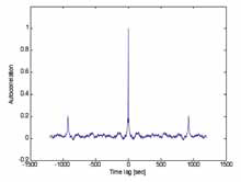
Figure 5 Doppler residuals obtained with a pass-through using the ZWD estimated by GPS measurements while the ZHD has been obtained via the standard ESA method The range-rate residuals shown in Figure 4 and Figure 5 seem very similar although, at a closer look, there is a marginal improvement in the residuals rms of Figure 5. Table 1 shows the mean value and the rms of the two sequences of range-rate residuals obtained with the two techniques. As expected, for the ESA standard calibration pass-through the mean value is zero, as the VEX orbital solution is based on the same residuals. On the other hand, a non-zero value of the mean of the range-rate residuals obtained using GPS-based tropospheric calibrations can be ascribed to the choice of non updating VEX orbit solution but just performing a pass-through. Although the rms improvement obtained using GPS-based tropospheric calibration is marginal and statistically not very significant, two important preliminary conclusions can be drawn: (1) the GPS-based S/W produces an estimated ZWD which is at least consistent with the one computed using standard, much simpler, methods; (2) the slight improvement shows that the GPS-based tropospheric calibrations obtained by the newly developed S/W might be more precise than those obtained using only standard meteorological data. In order to understand whether the lack of a major improvement can be ascribed to the presence of a significant plasma noise on Doppler data, the range-rate residuals where analyzed with statistical methods, searching for possible unambiguous traces of solar plasma noise. Range-rate residuals autocorrelation and spectral analysisIn order to perform a statistical analysis on the range-rate residuals, a new pass-through on VEX Doppler data was performed at a sampling rate of 1Hz, which allows having more data and then a more statistically significant estimation of both the autocorrelation function and power spectral density. The normalized autocorrelation function of the range-rate residuals in shown in Figure 6.
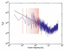
Figure 6 Normalized autocorrelation function of the VEX range-rate residuals, sampled at 1Hz In addition to the peak at zero time lag, a statistically significant peak shows up at exactly the average two-way-light-time (TWLT) during the pass, ~925 s. This means that the range rate residuals are dominated by noises concentrated at the Earth. On the other hand, the autocorrelation function is quite noisy all over the time-lags between zero and the TWLT, pointing to a diffuse noise source. This could easily be solar plasma which, at the Sun-Earth-Probe angle of 43 degrees of July 4th, 2009, impacted all along the RF beam. To test this hypothesis, we computed the power spectrum of two-way range-rate residuals converted to Hz. The Power Spectral Density (PSD) is shown in Figure 7. There are clearly two “zones” in the PSD plot: the one between 10-4 Hz and 10-1 Hz where the power spectrum of the frequency residuals follows a power law with a spectral index, computed by a least square fit of the power spectrum and a straight line, equal to p=−0.69, thus very close to p=−2/3 (associated to a Kolmogorov spectrum of a fully developed turbulence, compatible with solar plasma noise). The superimposed solid line is the fitting function f -0.69. In the second zone, between 10-1 Hz and 5×10⁻¹ Hz, the spectral line is dominated by thermal noise in the receiver and random processes which are consistent with antenna mechanical noise The superimposed black dashed line, obtained, again, with a least square fit, is f 0.93. The red vertical lines represent multiple frequencies of the TWLT, explaining the periodic modulation of the spectrum due to residual noise at the Earth due to troposphere and antenna mechanical noise.
Figure 7 Power Spectral Density of the VEX range-rate residuals, sampled at 1Hz ConclusionFor both VEX range-rate data processing, the residuals were formed, by using, the current best orbit determination solution available. The mean value and the rms of the two sets of range-rate residuals were compared, searching for an improvement: a reduction of the rms value of the range-rate residuals. The improvement was indeed present, although very marginal and not statistically significant. This may be caused, in addition to a poor tuning of the GPS-based tropospheric calibration S/W, by the presence of other noise sources in the range-rate data at hand, which might render ineffective the better Earth tropospheric calibrations. This has been shown to be the case, by performing a statistical analysis on the range-rate data and in particular by computing the normalized autocorrelation function and the power spectral density (PSD). VEX range-rate data acquired on July 4th, 2009 (a few days after VEX quadrature with the Sun and the Earth), seem to be quite affected by solar plasma noise which is clearly visible in the frequency range 10-4 Hz – 10-1Hz of the residuals PSD, where the power spectrum follows a power law with a spectral index ≈−2/3, associated to a Kolmogorov spectrum of a fully developed turbulence, compatible with solar plasma noise. Another possibility which will be investigated in the future is to use tracking data from the ESA’s Herschel and/or Planck S/C for tropospheric analysis purpose and the VEX mission during the inferior conjunction phase. AcknowledgmentsThe authors wish to thank Pedro Alfaro and Carlos Garcia-Martinez of ESAESOC for the CEBR RINEX data provided for the test. The work of A. Graziani, R. Bertacin and P. Tortora was funded in part by the Italian Space Agency (ASI). References[1] Bertotti, B.; Comoretto, G.; Iess, L., Doppler tracking of spacecraft with multi-frequency links, Astronomy and Astrophysics (ISSN 0004-6361), vol. 269, no. 1-2, p. 608-616, 03/1993 [2] Thornton C. L., Border J. S. Radiometric Tracking Techniques for Deep Space Navigation, JPL Deep Space Communications and Navigation Series 28 Jan 2005 [3] Krueger E., Schueler T., and Hein G. W., Martellucci A. Blarzino G., Galileo, Tropospheric Correction Approaches developed within GSTB-V1, Proceedings of GNSS 2004 – European Navigation Conference, Rotterdam, The Netherlands, 17-19 May 2004. [4] Graziani A., Bertacin R., Schiavone A., Tortora P., Martellucci A., Test Campaign of an Earth Troposphere Calibration System Based on Dual Frequency GPS measurements, XX AIDAA Congress, Milan, Italy, 2009 [5] Svedhem, H.; Titov, D.; Witasse, O., Venus Express – Mission Overview and present Status 37th COSPAR Scientific Assembly, p.3101, Montréal, Canada, 13-20 July 2008. [6] Warhaut, M. Martin, R. Claros, V., ESA’s new Cebreros station ready to support Venus Express, ESA Bulletin (ISSN 0376-4265), No. 124, p. 38 – 41, 2005 |
|||||||||||||||
|
|||||||||||||||
|
|||||||||||||||
|
|||||||||||||||
|
|||||||||||||||
|
|||||||||||||||
|


 (No Ratings Yet)


Leave your response!