| GIS | |
BIM is the New GIS
Building Information Modelling presents itself as a new opportunity for the surveying and spatial industry and education |
 |
|
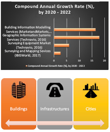
Data collection will not grow much
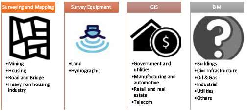
In general, our industry offers surveying and mapping services, survey equipment and GIS services. More recently it also provides BIM services. In the surveying and mapping, our industry offers data collection services, and at a higher level, it provides services related to the interpretation of the data like what degree of accuracy is required to achieve a specific goal, how property rights and restrictions should be designed, so the occupants have the best living experiences. We offer the surveying and mapping service to the mining, housing, infrastructure and heavy industries. Survey equipment is about technologies we use for data collection. There are two classes of data collection equipment, collecting data about land, and collecting data about water bodies, seas, oceans. GIS is about spatial data analytic and is offered to government, automotive, retail and telecom industries. We play a role in GIS, but the information technology sector is also active. The prominent example is Google. AEC offers BIM, and we are a small player regarding the share of the economy in the AEC. BIM services are offered to the building, infrastructure, oil and gas, utility industries. In the surveying and mapping, 40 percent of the service is cadastral surveying driven by land development. The hydrographic survey equipment sector is significantly larger than the land survey equipment sector and is driven by international trade. The retail and real estate industries account for 30 percent of GIS-driven by the consumer market.
Now, if we look at the growth rate of each of these industries, there is one clear message, and that is spatial data collection will grow very slowly. Land surveying equipment also has been affected by the availability of low-cost devices that can collect spatial data; low-cost drones now are used to update road network, traffic data and even in developing nations where the information gap is for cadastral surveying. The cost of collecting data will be increasing declined. What is fast growing is that what we can do with the data. Using GIS, we can predicate how fires spread, we can model how transport network behaves, etc. BIM will be no different to surveying and mapping if we only focus on the preparing building information. But we go beyond building information; we can discover a continuum of opportunities.
The continuum means that that if we plant the seed correctly, we can harvest it for a long time. A BIM includes spatial information of built environment; our industry is expert in spatial data. BIM is about collaborative and common data environments (CDE); we have expertise in spatial data management through SDI, we have standards for common spatial data environment and BIM data is no different. We have a longstanding expertise in generalising large-scale spatial data to create a smallscale map; the same principle applies to BIM. We can generalise BIM to create city models. One single building brings all these opportunities, creating BIM, creating CDE, maintaining the BIM data and converting it to city models.
BIM is full of opportunities
Nowadays, multi-storey and complex developments often include residential buildings, office buildings, and shopping facilities. Today’s developments create mix uses of land and space where a piece of land is turned to a complex with multiple owners and use with various levels of entitlements and liabilities.
Despite these complexities, we still subdivide such buildings very similar to what we do with the broad acre land. One would argue that we have hacked the land subdivision process and have taken the same approach to create stratified ownership. This approach cannot be sustainable for future. In these complex developments, determining whether the ownership of an apartment extends between faces of two walls, the median of the walls or exteriors faces of the walls can be a cognitive challenge for its owner. Ascertaining if owners are individually or collectively responsible for facades, services, shafts or cables can be a cognitive challenge for building operators.
BIM presents itself as an opportunity to be a source data for strata plans or building subdivisions. The way buildings are currently managed can be significantly improved by replacing 2D plans that challenge the cognitive capacity of building managers by BIM models that include the spatial extent of ownership information.
BIM provides the opportunity to bridge the long-standing gaps we have had in our cadastral databases in term of underground utilities. With BIM being able to accommodate essential services associated with an infrastructure, we now have a chance to integrate utility databases and cadastres together.
Site topography is an important part of a BIM. BIM can be used to upgrade our cadastres that have been essentially a flat representation of the real world. Depth limitations in individual title plans can be integrated, so it helps with the major infrastructure projects.
BIM provides opportunities to evolve our GIS technologies that are focused primarily on outdoor environments into technologies that can be used for indoors spatial analysis. For example, BIM, with the help of spatial analytics that our industry is expert in, can be used as a decision support system in emergency situations. For example, we can help transform traditional emergency practices of complex buildings.
Numerous and diverse technologies push cities towards 3D spatial information infrastructures to manage human, natural and physical systems. Spatial industry can benefit from BIM in enabling urban planning workflows using 3D data. BIM can be used as a source data for development approval processes including visualising and processing 3D spatial data when used in urban planning processes.
Surveying and spatial industry and education to take leadership in BIM
Analysing the value chain of the AEC and how BIM adds value to it, we can see there are three benefits in using BIM: increased data integration, information sharing, and complete digital information about buildings. Besides our expertise in collecting building information, we are experts in integrating, sharing and managing spatial information. This is an opportunity to play a bigger role in AEC. To develop business opportunities, we need to highlight and define what we can do through advocating BIM.
There are now numerous guidelines for dealing with BIM in AEC at the international and jurisdictional levels. For example, in Australia NATSPEC a national not-for-profit organisation has developed National BIM Guide which is a reference document that defines roles and responsibilities, collaboration procedures, approved software, modelling requirements, digital deliverables and documentation standards for projects in general.
However, guidelines for using BIM in surveying and spatial industry is missing. Private companies such as Plowman Craven provide BIM specification for the survey of buildings. There are also some initiatives by Open Geospatial Consortium and buildingSmart International that acknowledge GIS and BIM integration issues and work towards addressing them. We need much more comprehensive and widely accepted guidelines yet.
Finally, and perhaps more importantly, we need to rethink the geospatial engineering curriculum and upskilling the profession. There is an urgent need to update our training and education, so BIM is integrated and highlighted. BIM requires further attention in the spatial and surveying education.


 (4 votes, average: 1.00 out of 5)


Leave your response!