| Geodesy | |
The realization of [the] geocentric datum for Brunei Darussalam 2009
IntroductionReplacing the horizontal datum of a country is a complicated and difficult project. The decision to embark on such a “revolutionary” move should only be taken after in-depth studies to identify compelling reasons for such replacement. Here, we comment on the article by Tahir et al. published in the September 2011 issue of Coordinates. In this article, the authors discussed some aspects of the replacement of the horizontal datum of Brunei Darussalam–Timbalai 1948 with a geocentric datum known as the Geocentric Datum of Brunei Darussalam 2009 (GDBD2009). The article also outlines the selected map projection, Rectified Skew Orthomorphic (RSO).
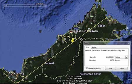
Figure 1. Brunei Darussalam and the Malaysian provinces of Sarawak and Sabah are located in the North-western section of Borneo. The yellow pin indicates the origin of the BRSO projection (N4o, E115o), which is coincidental with the origin of the “geocentric RSO.” The yellow line running diagonally across the picture marks the central line of both the BRSO and the geocentric RSO projections (azimuth 53o 18’ 56.91582”), and it passes through the origin of the projection. While the central line of the projections appears to be optimal for Sarawak and Sabah, it does not seem favourable to the territory of Brunei Darussalam. Source: Background image, Google Earth®; the pin and the central line – own work When a country should change its geodetic datum?The relatively recent developments in GNSS technology have dramatically changed the modi operandi of geodesy and the surveying profession to an extent that, wherever possible, GNSS has replaced traditional surveying methods, including traversing and triangulation. The widespread adoption of the GNSS technology which uses the geocentric datum promotes replacing local datums with a geocentric datum similar to the datum used by the GNSS systems. Already in 1990, FIG has been recommended this datum migration by countries around the world. Soon after, in 1991, the maritime nations associated with the International Hydrographic Organisation (IHO) have recommended the production of future navigational charts on a geocentric datum. This move was followed by the International Civil Aviation Authority (ICAO), which decided to conduct its operations in relations to a geocentric datum. In 1994, at the United Nations Regional Cartographic Conference for Asia and the Pacific, participants resolved to adopt a geocentric datum as soon as possible. This conference also established the Permanent Committee on GIS Infrastructure for Asia and the Pacific (PCGIAP) to develop a common datum in the region. Some of PCGIAP member countries have already adopted geocentric datums. According to the EPSG database, until December 2011, over 80 countries have already adopted a geocentric datum. Among of them, since 2009, is Brunei Darussalam.
It is expected that this trend will continue in the future, despite all the efforts required, and despite an increase in positioning errors caused by the usually larger separation between geoid and the geocentric ellipsoid (plumb line deflection).
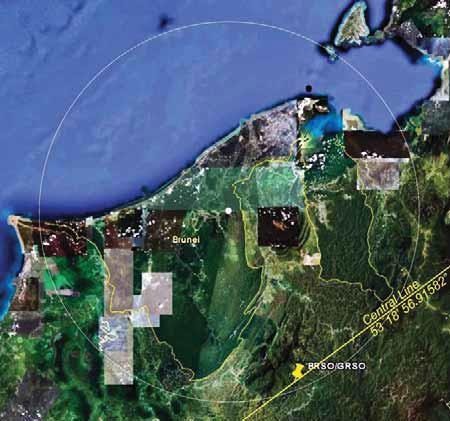
Figure 2. The approximate geometric centre of the territory of Brunei Darussalam is marked with a white spot in the centre of the picture. The radius of the white circle containing the entire territory of Brunei Darussalam, including the coastal waters, is approximately 80 km. The yellow pin indicates the centre of the BRSO/GRSO projection (N4o, E115o). The yellow line represents the central line of both projections. Source: Own work; background image, Google Earth® Some comments on the selected map projectionIn the article, Tahir et al. (2011) stated the following to justify the adoption of the same map projection as the previous one, i.e. the RSO projection: “For many years, Brunei Darussalam has been using the Borneo Rectified Skew Orthomorphic (BRSO) projection for the country…” The RSO map projection was adopted in 1948 long before Brunei gained its independence, i.e., when the country, together with Sarawak and Sabah, was still under British rule. Figure 1 provides basic information on the RSO projection, including the centre of the projection (4o N, 115o E) and the central line of the projection, which passes through the central point at the azimuth 53o 18’ 56.91582.” This type of map projection was adopted to optimally map the oblique shape of the then area of interest (Sarawak, Brunei and Sabah). Since then, Brunei Darussalam has managed its geodetic needs on its own. The country would be expected to select a projection that best suits its current territorial area and shape. Figure 2 shows that the shape of the country resembles a circle. There is, therefore, no reason to use the RSO projection, especially with the central line and the point of origin of the projection outside of its territory. By adopting the RSO projection with these parameters, Brunei is overlooking the fact that the scale along the central line is the true one. A note on the terminologySince 1948, the official name of the geodetic datum used in Brunei, Sarawak and Sabah is Timbalai 1948. This name continues to be used in Brunei after the country regained its independence. On all topographic and other maps produced in Brunei, this name is used to refer to the geodetic datum. In addition, Timbalai 1948 is used on the Navy Charts produced by the British Admiralty. Software manufacturers, including ESRI and ERDAS, refer to the datum used in Brunei as the Timbalai 1948 datum. This name is also listed in the EPSG database. Yet, for unclear reasons, Tahir et al. (2011) refer to the Brunei geodetic datum as the Borneo Triangulation 1948 or BT48. It is unclear as to why the Survey Department of Brunei Darussalam supports this inconsistency in the terminology. History provides plenty of examples that these types of inconsistencies are frequent sources of confusion in the geodetic, surveying and mapping communities. Conclusion1. Based on the above, the Survey Department should be congratulated for the bold reform of the geodetic datum through the adoption of the geocentric datum – GDBD2009.
2. Confusion may arise from the statement that “With GDBD2009, geodetic coordinates of a point determined in WGS84 using GPS could be directly projected to their related geocentric RSO plane coordinate values [without the need transforming them to GDBD2009 first – added by the Authors].” This simply implies that GDBD2009 datum is not necessary, because the WGS84 coordinates may be directly projected to the “geocentric” RSO.
3. The RSO map projection for Brunei Darussalam is not an appropriate one because the mapped territory (onshore and offshore) has a circular shape (does not have any prevailing direction). The RSO projection is used for mapping territories which are extended in a particular direction such as the East Malaysian states of Sarawak and Sabah taken together.
4. The parameters of the “geocentric” RSO are not optimal for Brunei because the central line of the projection (the distortion-free line) does not pass through the territory of the country at all.
5. To avoid confusion, the well-established name of the disposed Brunei geodetic datum – Timbalai 1948, should be used, rather than its alias (BT48).
ReferencesTahir, M. M., Ali, M. J., Omar, K., Abdullah, K. A., Musa, T, A. & Othman, R., (Sep. 2011). The realization of geocentric datum for Brunei Darussalam 2009. Coordinates, online magazine: https://mycoordinates.org/the-realizationof- geocentric-datum-for-brunei-darussalam-2009/
|


 (5 votes, average: 2.00 out of 5)


Leave your response!