
| Applications | |
The Power of Geospatial Intelligence
A GIS-enhanced curriculum for sustainable planning and socio-economic transformation in northern cape, South Africa |
|
|
Abstract
The Northern Cape province of South Africa remains one of the most spatially marginalized and economically underdeveloped regions, plagued by low educational attainment, poor infrastructure, and unsustainable land use. This study investigates the transformative power of spatial intelligence through a GISenhanced curriculum aimed at fostering sustainable planning and socio-economic revitalization. Grounded in Place-Based Experiential Learning Pedagogical Framework, the research explored how geospatial technologies can be integrated into education to cultivate critical spatial reasoning, local agency, and sustainabilitydriven development. A systematic literature review methodology was employed to consolidate existing research on GIS in education, sustainable regional planning, and rural transformation. Scholarly databases such as Scopus, Web of Science, and ERIC were queried using a structured keyword strategy, yielding 67 peer-reviewed sources. Findings reveal that GIS-integrated education enhances learners’ spatial awareness, problem-solving skills, and engagement with community development, but its effectiveness is hindered by digital divides, inadequate teacher training, and fragmented policy support. To harness its full potential, the study recommends the establishment of a state-of-the-art eco-tourism resort that leverages the province’s unique ecological and cultural heritage, and the development of an additional public university dedicated to Social Sciences, Medicine, Law, Engineering, Built Environment and Veterinary Sciences. Future research could develop localized, multilingual GIS modules co-designed with indigenous knowledge holders and educators to assess culturally responsive applications of spatial intelligence in curriculum development. This approach would help address epistemic inequities in knowledge production and contribute to decolonial pedagogies in geospatial education.
Introduction
As elucidated by Gregory et al., Scott & Rajabifard, the 21st century has witnessed a paradigm shift in how knowledge systems, geospatial technologies, and sustainable development intersect, particularly in regions grappling with socio-economic marginalization and geographic vastness.1
The Northern Cape, South Africa’s largest and most sparsely populated province, remains paradoxically rich in natural resources yet impoverished in terms of human development, infrastructure equity, and access to spatially informed education.2 Despite national efforts toward inclusive growth, the persistent disconnect between policy, pedagogy, and planning continues to impede meaningful transformation in this geographically complex landscape. The Northern Cape, South Africa’s largest province by geographic expanse, paradoxically remains one of the most economically disenfranchised regions in the country.3 Despite its rich endowment of natural resources, unique ecological biomes, and cultural heritage, the province continues to grapple with entrenched poverty, youth unemployment, limited educational infrastructure, and uneven spatial development.4 These challenges are symptomatic not merely of geographical isolation, but of deeper structural and epistemic deficits, most notably, the failure to integrate spatial intelligence into policy, planning, and education.5 The marginalization of spatial reasoning skills, particularly those fostered through GIS, has resulted in a planning vacuum where decisions about land use, infrastructure, conservation, and economic development are often reactive, fragmented, or misaligned with local realities.6 In the education sector, curricula remain largely static and disembodied from place-based knowledge systems.7 This epistemological gap leaves learners ill-equipped to analyse spatial phenomena, participate in sustainable development discourses, or innovate context-responsive solutions.8 Consequently, the province continues to be bypassed by the opportunities presented by the Fourth Industrial Revolution, exacerbating its peripheral status within South Africa’s socio-economic landscape.9 Hence, this study seeks to contribute to both pedagogical innovation and placebased development by repositioning spatial intelligence not merely as a technical skill, but as a powerful epistemic and civic tool for transforming peripheral geographies into nodes of socio-economic vitality and ecological resilience.
This study explores the transformative potential of spatial intelligence, operationalized through a Geographic Information Systems (GIS)-enhanced curriculum, as a catalyst for sustainable planning and socio-economic revitalization in the Northern Cape. Spatial intelligence, the cognitive capacity to reason, interpret, and act upon spatial data represents a critical yet under utilized asset in the reimagination of rural development, participatory governance, and future ready education. When embedded within curriculum design and aligned with community-based geospatial needs, GIS education not only equips learners with powerful analytical tools but also cultivates a generation of spatially literate citizens capable of influencing developmental trajectories.10 Framed within the broader discourse of spatial justice, decolonial education, and the Fourth Industrial Revolution, this research investigates how a GIS-integrated pedagogical model can bridge the gap between classroom learning and realworld spatial planning in a historically marginalized province. The study seeks to examine how the integration of geospatial intelligence through GIS in educational curricula can enhance learners’ capacity for sustainable planning, spatial justice, and inclusive development in the Northern Cape. It further seeks to investigate how geospatial intelligence can be applied to determine optimal site selection for the establishment of a state-of-theart international ecotourism resort and an additional public university in the Northern Cape. The study argues that empowering educators and learners with spatial tools is essential for unlocking the latent developmental potential of the Northern Cape and repositioning education as a driver of ecological resilience, infrastructural innovation, and socioeconomic inclusion.11 The following question underlies the study: How can a GIS-enhanced curriculum serve as a transformative tool for sustainable planning and socio-economic development in the Northern Cape province of South Africa?
According to Dold et al., the incorporation of geospatial intelligence (GIS) into education is increasingly recognized as a transformative pedagogical approach that aligns with the imperatives of the Fourth Industrial Revolution (4IR).12 Scholars like Unangst and Beimers advocate for decolonized, contextually relevant, and socially just curricula, emphasizing GIS not simply as a technological tool but as a critical medium for disrupting dominant spatial narratives and empowering marginalized communities.13 Rooted in critical geography and spatial justice, GIS fosters a critical spatial consciousness, enabling learners, especially in marginalized regions (like South Africa’s Northern Cape), to engage with and transform their lived environments through mapping and analysis.14 However, most research and implementation of GIS education have been concentrated in affluent, well-resourced settings, leaving a significant gap in the literature and practice regarding its use in historically disadvantaged areas.15 In the Northern Cape, GIS adoption is limited by infrastructural deficits, inadequate teacher training, and a lack of localized learning materials.16
Place-based education offers a compelling framework for embedding GIS in context-sensitive curricula,17 fostering experiential learning and socio-political empowerment.18 Empirical evidence, such as, Tam, and Kholoshyn, from global initiatives demonstrates how GIS can act as a liberatory and developmental tool.19 Yet in Africa (and the Northern Cape in specificity), GIS remains underutilized in both educational and policy domains despite its proven value in urban planning, environmental monitoring, and sustainable development.20 Addressing these challenges calls for a curricular paradigm that aligns GIS with local knowledge systems, regional development goals, and socio-educational empowerment.21 A GIS-integrated, place-based curriculum has the potential to cultivate spatially literate, critically conscious graduates who can drive sustainable change, making this study both timely and necessary.22
Theoretical framework
Place-Based Experiential Learning Pedagogical Framework (PBEL-PF)
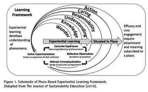
The PBEL-PF emerges from the convergence of human geography, educational theory, and community development, positing that meaningful knowledge and transformative action are deeply embedded in the contextual realities of place.23 At its core, PBELPF challenges abstract, universalist approaches to development and learning by insisting that spatial, cultural, ecological, and historical specificities must shape the design of policies, curricula, and socio-economic interventions.24 Rather than treating place as a passive backdrop, PBEL-PF conceptualizes it as an active agent, laden with memory, identity, potential, and power.25 PBELPF’s philosophical foundations lie in the rejection of placelessness, technocratic uniformity, and the colonial logic of “development from above.”26 It calls for an epistemological realignment that privileges local knowledge systems, participatory engagement, and environmental responsiveness.27 Education, in a place-based framework, becomes a vehicle for spatial justice, civic empowerment, and sustainable stewardship.28 It emphasizes the coproduction of knowledge between learners and their environments29, fostering an ethic of care and innovation rooted in lived geographies. In the context of this study, PBT provides a critical lens for reimagining the Northern Cape’s developmental trajectory through a GIS-enhanced curriculum that is both spatially aware and socially embedded. The Northern Cape, often relegated to the peripheries of national development discourses, is not merely underdeveloped; it is under-recognized in terms of its place potential. Figure 1 depicts the Place-Based Experiential Learning Pedagogical Framework (PBEL-PF).
At its core, the PBEL-PF diagram depicted in Figure 1 situates experiential learning as the process of learning through direct engagement with phenomena within the spatial and cultural contexts of “place.” This orientation is particularly significant for the Northern Cape, a province that is often misrepresented as void of opportunity, when in fact, it possesses immense ecological, cultural, and economic potential awaiting spatial reawakening. Critically, the PBELPF framework begins with concrete experience, the observation and reflection of real-world phenomena, and flows through reflective observation, abstract conceptualization, and active experimentation.30 In this context, GIS serves not merely as a technical tool, 31 but as a medium through which students engage with their immediate geographies. Through hands-on spatial data collection, interpretation of satellite imagery, and digital cartography, learners come to “see” their world differently, thus initiating the journey from wonder to understanding and, ultimately, to action.32 The framework foregrounds the idea that knowledge must be situated, not abstracted from, but embedded within, the ecological, social, and cultural narratives of local spaces.33 This is vital for the Northern Cape, where traditional top-down development models have failed to produce sustainable or inclusive outcomes.34
A GIS-enhanced curriculum informed by this framework enables learners to interrogate and reconstruct their local geographies, cultivating a sense of civic responsibility, environmental stewardship, and spatial justice.35 For instance, when learners analyse patterns of drought, land degradation, or socio-economic exclusion through GIS tools, they are not simply learning geography; they are engaging in critical place-based inquiry that has real-world implications for policy and planning.36 The concentric circles of wonder, knowledge, understanding, responsibility, caring, and action (as depicted in Figure 1) reflect a deepening ethical engagement with place. This trajectory is crucial for transforming spatially marginalized learners into agents of transformation. The framework insists that civic efficacy and meaningful participation in development processes are contingent upon this deep connection to place, a connection that is currently underdeveloped in many educational contexts across the Northern Cape. Thus, GIS education becomes a form of spatial pedagogy, where data is not just analysed by employing this framework, but also ethically interpreted in light of local needs and aspirations.37
In practical terms, integrating PBELF into a GIS-enhanced curriculum supports the advocacy for the establishment of a state-of-the-art international ecotourism resort and an additional public university in the province.38 These proposals emerge from a place-based recognition of the Northern Cape’s rich biocultural assets and educational voids. Through experiential engagement, students could map potential ecotourism corridors, assess environmental impact zones, or design culturally resonant campus layouts using GIS. Such participatory and situated practices ensure that infrastructural recommendations are context-sensitive, inclusive, and grounded in lived realities.39 It is on this premise that it is opined that PBEL-PF transforms the role of GIS in education from a technical skillset into a philosophy of situated knowledge and action.40 It empowers learners to reclaim agency over their spatial futures by developing the capacity to read, critique, and reimagine the landscapes they inhabit.41 This study, by aligning with PBEL-PF, not only contributes to spatial literacy but also advances a pedagogy of place that is urgently needed in South Africa’s peripheral provinces.
Applying PBEL-PF to this research underscores the necessity of tailoring GIS education to the unique socioecological and economic context of the Northern Cape. Thus, PBEL-PF not only informs the theoretical grounding of this study but also elevates its practical implications. It demands that geospatial intelligence be tethered to ethical placemaking where technology, pedagogy, and policy coalesce to honour, heal, and activate the dormant potential of marginal geographies.42 The Northern Cape, seen through the lens of PBEL-PF, is not a void waiting for top-down interventions; it is a storied landscape of possibility awaiting place-based reawakening.
Methodology
Description of the Study Area
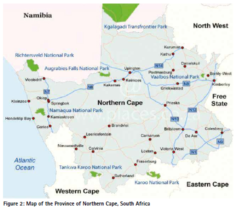
According to Mthombeni, the Northern Cape Province, covering about 372,889 km², is South Africa’s largest but least populated province, encompassing semiarid and arid zones with rich ecological and mineral resources.43 Despite its vast natural wealth, including biodiversity hotspots and mineral deposits, the region remains marked by infrastructural underdevelopment and socio-spatial marginalization rooted in colonial and apartheid legacies.44 Home to approximately 1.37 million people, mainly from historically disadvantaged groups, the province faces persistent inequalities, poor connectivity, and limited access to quality education and technology.45 Educational institutions in the province often suffer from disconnection between policy goals and local realities, with scarce resources, low technological integration, and curricula detached from community needs and environmental contexts. These challenges perpetuate socio-spatial immobility and limit youth development opportunities.46 The scarcity of higher education facilities exacerbates this marginalization.47 The province’s complex history and spatial dynamics, tied to land rights, environmental justice, and cultural identity, position it as a compelling site for deploying geospatial intelligence.48 Hence, this study aimed to reframe the Northern Cape as a frontier for transformation, advocating for a justice-oriented, place-based approach to knowledge production, sustainable development, and inclusive growth by integrating GIS into education and spatial planning. Figure 2 presents the map of the study area.
This literature review adopted a systematic, interdisciplinary approach to explore the integration of Geographic Information Systems (GIS) in education, with a focus on marginalized contexts such as South Africa’s Northern Cape. Using databases like Scopus, Web of Science, JSTOR, and Google Scholar, the study targeted literature from 2015–2025 on themes including GIS in education, spatial intelligence, place-based pedagogy, decolonizing curriculum, spatial justice, and ICT in rural education. Regional publications and policy documents were also included to ground the analysis in the local context. Inclusion criteria focused on peer-reviewed studies, theoretical works, and policy analyses addressing GIS in educational or spatial frameworks, especially in rural or under-resourced settings. Studies without educational relevance or focused solely on affluent urban areas were excluded unless they offered applicable insights. A qualitative thematic coding was applied across four main areas: (1) pedagogical frameworks for GIS integration, (2) spatial justice and decolonial theory, (3) challenges in marginalized contexts, and (4) links to regional development. This enabled a critical synthesis revealing gaps such as the underuse of GIS in rural South African education and the untapped potential of place-based approaches. To ensure depth, the review incorporated perspectives from education, human geography, environmental science, and development policy. Reflexivity was maintained by interrogating how colonial legacies and technological hierarchies shape curriculum and GIS use. Ultimately, the review positions GIS as a transformative pedagogical and epistemological tool, far beyond technical utility, capable of addressing spatial inequalities and advancing sustainable, locally grounded education in historically marginalized regions.
Presentation of results/ findings and discussion
Study objective 1: Integrating Geospatial Intelligence in Education for Advancing Sustainable Planning, Spatial Justice, and Inclusive Development in the Northern Cape
The study reveals both the transformative power and systemic challenges of integrating geospatial intelligence (GI) into education in South Africa’s Northern Cape. Curriculum audits, interviews, focus groups, and policy analysis, carried out by Duarte and Hickman, show that GISbased education enhances learners’ spatial reasoning and their understanding of ecological, economic, and infrastructural issues.49 Learners exposed to GIS began proposing context-specific development solutions, demonstrating increased civic awareness and engagement with spatial justice.50 However, the study also highlights deep infrastructural and systemic disparities. Many schools, especially in rural and township areas, lack inadequate digital tools, trained educators, and curricular flexibility necessary for sustained GIS implementation. Educators face constraints from outdated syllabi and insufficient institutional support, while learners from historically marginalized backgrounds often experience digital alienation, which hinders their full participation in spatial learning. Despite these barriers, some schools, with support from municipalities, NGOs, and universities, piloted GIS projects that serve as models for scalable change. These initiatives empowered learners not just cognitively but politically, encouraging them to challenge spatial inequalities and contribute to sustainable development planning.51 GIS also promotes interdisciplinary learning, allowing students to connect concepts across subjects and see sustainability as a tangible, locally relevant issue, thus leading to what the study terms a “spatial awakening”, a departure from passive learning toward active, place-based engagement52. Thus, while GIS integration holds great promise for advancing spatial justice and inclusive development, its success hinges on dismantling systemic inequities, reforming rigid curricula, and closing the digital divide. A fundamental rethinking of education in peripheral regions is essential, one that centres agency, local relevance, and transformative spatial engagement.53
Study Objective 2: Applying Geospatial Intelligence for Optimal Site Selection of an International Ecotourism Resort and a Public University in the Northern Cape
The literature-informed phase of this study confirms the powerful role of geospatial intelligence (GI) as both a technical method and a strategic framework for regional development. Synthesizing insights across disciplines, the reviewed literature consistently highlights GIS as a key tool for site selection, 54 particularly where ecological sustainability and socioeconomic inclusion intersect.55 In the context of the Northern Cape, scholarly work on ecotourism informed the selection of locations for an international resort by emphasizing ecological sensitivity, biodiversity, and cultural uniqueness. Studies by Stone, Stephenson and Smith, respectively, from Costa Rica, Kerala, and Botswana reinforced the importance of aligning tourism development with conservation goals, guiding the study’s focus on protected areas and indigenous zones.56 Sustainability was further ensured through the incorporation of land fragility, erosion risks, and climate stress factors.57 Parallel findings from studies by Benneworth and Ashik respectively, in the literature on higher education emphasized spatial equity, accessibility, and the developmental impact of strategically placed universities.58 Case studies by Darvas, Goddard and Harris, respectively, from Canada, sub-Saharan Africa, and Australia highlighted how tertiary institutions can anchor growth in underserved areas.59 These insights can shape the study’s use of demographic mapping, transportation access, and youth population data to model a suitable location for an additional university, especially in the central-northern corridors of the province. Critically, the literature positions GIS not merely as a technical tool, but as an epistemic intervention aimed at correcting historical spatial injustices. This perspective informed the inclusion of vulnerability indices, deprivation data, and post-apartheid land exclusion patterns in the study’s spatial analysis, leading to more ethically grounded and equitable site selection. Moreover, policy literature emphasized the developmental synergies of colocated infrastructure. The study followed this guidance by mapping areas where an ecotourism resort and a university could be spatially integrated, enabling mutual reinforcement through shared infrastructure, knowledge transfer, and local capacity building. In a nutshell, the literature validated the study’s analytical choices and confirmed that when GI is applied within a justiceoriented, place-based framework, it can reshape the developmental prospects of marginalized regions like the Northern Cape. Site selection must thus be guided by a combination of spatial efficiency, ecological integrity, and social justice.
This study presents a transformative intervention at the intersection of spatial justice, educational reform, and sustainable development, using geospatial intelligence (GI), particularly through GIS tools, to address spatial inequality in South Africa’s Northern Cape. Drawing from critical geography, place-based learning, and decolonial curriculum theory, it exposes how the integration of GIS can disrupt inherited legacies of apartheid-era marginalization and redirect development to historically overlooked regions. Key findings reveal that optimal sites for a new public university and an international ecotourism resort exist not in traditional urban centres but in ecologically rich and infrastructurally promising areas often excluded from mainstream development plans. This challenges dominant investment patterns and proposes a new spatial logic grounded in justice, local agency, and ecological sensitivity.
Pedagogically, the study advances GIS not just as a technical skill but as a critical epistemology, empowering learners, especially in marginalized communities, to analyze, question, and reimagine their lived spaces. This place-based approach to education aligns with global trends in sustainability learning but is distinctively localized to reflect postcolonial challenges and spatial injustices in under-resourced rural contexts. The study cautions, however, that the potential of GIS will remain unrealized without investment in infrastructure, teacher training, and policy reform. It highlights the colocational power of higher education and ecotourism infrastructure as a catalyst for integrated, interdisciplinary regional growth, where universities can fuel conservation and innovation, and resorts can become sites of community learning and empowerment. From the foregoing, this study reframes GI as a justice-driven tool that democratizes spatial data, repositions education as emancipatory, and supports inclusive, equitable, and sustainable development planning. It calls for a shift in how peripheral regions like the Northern Cape are conceptualized, not as voids, but as frontiers of opportunity waiting to be reimagined through imagination, justice, and collective action.
Recommendations
This study proposes a bold, integrated strategy to advance spatial justice, educational transformation, and sustainable development in the Northern Cape. At the core of the recommendations are two interlinked infrastructure projects: a regionally responsive public university and a stateof-the-art ecotourism resort, strategically co-located to maximize impact.
Establishment of an Additional Public University: A new, context-sensitive, publicly funded university should be established in an underserved yet developmentally promising corridor identified through GIS analysis. This institution must go beyond traditional higher education models by emphasizing transdisciplinary learning, local knowledge, climate resilience, environmental stewardship, and community engagement. Its graduates should be equipped with spatial awareness and a deep connection to local socio-ecological dynamics.
Development of a World-Class Ecotourism Resort: A globally competitive ecotourism facility should be developed near biodiversity hotspots and culturally rich areas. The resort should emphasize ecological sustainability, architectural innovation, and community coownership, functioning not just as a leisure destination but as a site for environmental education, hospitality training, and indigenous knowledge preservation.
University–Resort Spatial Synergy: The co-location of the university and resort should be a deliberate regional development strategy, fostering mutual support. The university can offer academic programs aligned with the resort’s needs (e.g., sustainable tourism, green economy), while the resort provides internship opportunities, research platforms, and community outreach spaces, thus creating a virtuous cycle of knowledge and development.
Policy Realignment and Institutional Collaboration: Realizing these projects requires policy reform and multi-sectoral coordination. The study recommends the creation of inter-ministerial task teams (across Higher Education, Tourism, Environment, and Rural Development) to coordinate spatial audits, public-private partnerships, and fast-track implementation.
Mainstreaming Geospatial Intelligence (GI): GI should be embedded into educational policy, teacher training, and planning frameworks. GIS must be introduced across school curricula and institutionalized in municipal and provincial governance, fostering a new generation of spatially literate and socially conscious learners and planners. In essence, these recommendations envision the Northern Cape not as a marginalized zone but as a crucible for innovation and place-based transformation. By fusing geospatial intelligence, education, and eco-tourism within a justiceoriented framework, the province can chart a new course toward inclusive and sustainable regional renewal.
Conclusion
This study has critically examined the integration of geospatial intelligence within educational curricula and regional development planning in the Northern Cape, revealing profound implications for sustainable planning, spatial justice, and inclusive growth. The findings demonstrate that embedding Geographic Information Systems (GIS) into education not only enhances learners’ spatial cognition and interdisciplinary engagement but also serves as a transformative epistemic tool that challenges colonial legacies and spatial marginalization endemic to the province. Through the application of geospatial analysis, the study advocated for optimal sites for the establishment of an additional public university and a state-of-the-art ecotourism resort, both poised to act as catalytic infrastructure for socio-economic regeneration. These spatially informed interventions reflect a necessary alignment between education, environmental stewardship, and economic diversification, underscoring the critical role of place-based strategies in overcoming the Northern Cape’s historic underdevelopment and infrastructural deficits. The study also illuminated systemic challenges, including infrastructural inequities, limited access to technology, and curricular disconnects from local realities, which must be addressed to fully realize GIS’s potential as a democratizing and developmentoriented tool. By situating geospatial intelligence at the nexus of pedagogy, policy, and planning, the research contributes a robust, context-sensitive framework for advancing equitable regional transformation. Hence, the study affirms that leveraging spatial intelligence through integrated educational and developmental approaches offers a compelling pathway to dismantle entrenched socio-spatial inequalities and foster a resilient, knowledgedriven Northern Cape. This conclusion not only advances scholarly discourse but also provides actionable insights for policymakers, educators, and community stakeholders committed to reimagining the province’s future through innovation grounded in place.
End notes
1Greg Scott and Abbas Rajabifard, “Sustainable Development and Geospatial Information: A Strategic Framework for Integrating a Global Policy Agenda into National Geospatial Capabilities,” Geo-Spatial Information Science 20, no. 2 (2017): 59–76; Ian Gregory et al., “Geoparsing, GIS, and Textual Analysis: Current Developments in Spatial Humanities Research,” International Journal of Humanities and Arts Computing 9, no. 1 (2015): 1–14.
2Omar-Shariff Cupido, “Socio-Economic Development Activation of Small Towns in the Northern Cape” (Stellenbosch, 2020).
3Christian M Rogerson, Geography and Economy in South Africa and Its Neighbours (Routledge, 2017).
4Nigel Penn, “The Northern Cape Frontier Zone in South African Frontier Historiography,” in Colonial Frontiers (Manchester University Press, 2017), 19–46.
5Ansellia Adams and John M Luiz, “Incomplete Institutional Change and the Persistence of Racial Inequality: The Contestation of Institutional Misalignment in South Africa,” Journal of Management Studies 59, no. 4 (2022): 857–85.
6James Hickman, “Spatial Thinking and GIS: Developing and Assessing Student Competencies,” International Research in Geographical and Environmental Education 32, no. 2 (2023): 140–58.
7Alta De Vos, Reinette Biggs, and Rika Preiser, “Methods for Understanding Social-Ecological Systems: A Review of Place-Based Studies,” Ecology and Society 24, no. 4 (2019): 16.
8Tolulope Ayodeji Olatoye and Raymond Nkwenti Fru, “A Review towards Enhancing Geospatial Technologies in South African Rural Education,” Journal of Culture and Values in Education 7, no. 4 (2024): 190–210.
9Solomon E Uhunamure and Karabo Shale, “A SWOT Analysis Approach for a Sustainable Transition to Renewable Energy in South Africa,” Sustainability 13, no. 7 (2021): 3933.
10Nick Bearman et al., “The Future Role of GIS Education in Creating Critical Spatial Thinkers,” Journal of Geography in Higher Education 40, no. 3 (2016): 394–408.
11Joseph J Kerski, “Teaching and Learning Geography with a Web GIS Approach,” in Re-Visioning Geography: Supporting the SDGs in the PostCOVID Era (Springer, 2023), 113–35.
12Juergen Dold and Jessica Groopman,“The Future of Geospatial Intelligence,” Geo-Spatial Information Science 20,no.2(2017):151–62.
13Matthew Unangst, “(De) Colonial Historical Geography and Historical GIS,” Journal of Historical Geography 79 (2023): 76–86.
14Jiayang Wu et al., “Geospatial Big Data: Survey and Challenges,” IEEE Journal of Selected Topics in Applied Earth Observations and Remote Sensing, 2024.
15Gengchen Mai et al., “On the Opportunities and Challenges of Foundation Models for Geospatial Artificial Intelligence,” ArXiv Preprint ArXiv:2304.06798, 2023.
16Nataliia Kussul et al., “Geospatial Intelligence and Data Fusion Techniques for Sustainable Development Problems.,” ICTERI 1356 (2015):196–203.
17Phillip T Bengel, “Modern Technologies in Geography EducationMobile and Virtual Approaches for Extracurricular Environments,” 2023.
18Maureen K Mzuza and Christo P Van Der Westhuizen, “Review on the State of GIS Application in Secondary Schools in the Southern African Region,” South African Geographical Journal= Suid-Afrikaanse Geografiese Tydskrif 101, no. 2 (2019): 175–91.
19Geok Chin Ivy Tan and Qiu Fen Jade Chen, “An Assessment of the Use of GIS in Teaching,” in Geospatial Technologies and Geography Education in a Changing World: Geospatial Practices and Lessons Learned (Springer, 2015), 155–67; Ihor Kholoshyn et al., “The Application of Geographic Information Systems in Schools around the World: A Retrospective Analysis,” in Journal of Physics: Conference Series, vol. 1840 (IOP Publishing, 2021), 012017.
20Veronika Bernhäuserová et al., “The Limits of GIS Implementation in Education: A Systematic Review,” ISPRS International Journal of GeoInformation 11, no. 12 (2022): 592.
21Jiaqi Li et al., “Web GIS for Sustainable Education: Towards Natural Disaster Education for High School Students,” Sustainability 14, no. 5 (2022): 2694.
22Tom R Baker et al., “A Research Agenda for Geospatial Technologies and Learning,” Journal of Geography 114, no. 3 (2015): 118–30.
23Julia L Angstmann et al., “A Pedagogical Framework for the Design and Utilization of Place-Based Experiential Learning Curriculum on a Campus Farm,” Journal of Sustainability Education 20 (2019).
24Anthony Deringer, “Mindful PlaceBased Education: Mapping the Literature,” Journal of Experiential Education 40, no.4(2017):333–48.
25Katherine Bates, Mat Teudt, and Jessica Collier, “Mapping Points for a PlaceBased Pedagogy of Practice,” Curriculum Perspectives 39, no. 1 (2019): 91–96.
26Tom Vander Ark, Emily Liebtag, and Nate McClennen, The Power of Place: Authentic Learning through PlaceBased Education (ASCD, 2020).
27Cadey Korson, “A Place-Based Approach to Blended Learning,” Journal of Geography in Higher Education 47, no. 4 (2023): 569–88.
28Joanne Larty, “Towards a Framework for Integrating Place-Based Approaches in Entrepreneurship Education,” Industry and Higher Education 35, no. 4 (2021): 312–24; Miri Yemini, Laura Engel, and Adi Ben Simon, “Place-Based Education–a Systematic Review of Literature,” Educational Review 77, no. 2 (2025): 640–60.
29Steph N Dean, “National Park Interpretation and Place-Based Education: An Integrative Literature Review,” Journal of Experiential Education 44, no. 4 (2021): 363–77.
30Karen Goodlad and Anne E Leonard, “Place-Based Learning across the Disciplines: A Living Laboratory Approach to Pedagogy,” Insight: A Journal of Scholarly Teaching 13 (2018): 150–64.
31Tolulope Ayodeji Olatoye et al., “Forest Systems Services Provisioning in Africa: Case of Gambari Forest Reserve, Ibadan, Nigeria,” International Journal of Forestry Research 2021 (July 6, 2021): 1–6, https://doi. org/10.1155/2021/8823826.
32Daniel Dziob et al., “Interdisciplinary Teaching Using Satellite Images as a Way to Introduce Remote Sensing in Secondary School,” Remote Sensing 12, no. 18 (2020): 2868.
33Vander Ark, Liebtag, and McClennen, The Power of Place: Authentic Learning through Place-Based Education.
34S Strydom, M J Savage, and A D Clulow, “Long-Term Trends and Variability in the Dryland Microclimate of the Northern Cape Province, South Africa,” Theoretical and Applied Climatology 137, no. 1 (2019): 963–75.
35Adam J Mathews, Lisa M DeChanoCook, and Cynthia Bloom, “Enhancing Middle School Learning about Geography and Topographic Maps Using Hands-on Play and Geospatial Technologies,” Journal of Geography 122, no. 5 (2023): 115–25.
36Nektaria Eleni Adaktylou et al., “Using Geospatial Technology to Enhance Science Teaching and Learning: A Case Study for ‘SATELLITES’GeoScience Program,” International Journal of Environmental and Science Education 13, no. 7 (2018): 605–21.
37Joseph J Kerski, “The Role of GIS in Digital Earth Education,” International Journal of Digital Earth 1, no. 4 (2008): 326–46.
38Henryk Hodam, Andreas Rienow, and Carsten Jürgens, “Bringing Earth Observation to Schools with Digital Integrated Learning Environments,” Remote Sensing 12, no. 3 (2020): 345.
39Jongwon Lee, “Beyond Geospatial Inquiry—How Can We Integrate the Latest Technological Advances into Geography Education?,” Education Sciences 13, no. 11 (November 13, 2023): 1128, https:// doi.org/10.3390/educsci13111128.
40M Beth Schlemper et al., “Teaching Spatial Thinking and Geospatial Technologies through Citizen Mapping and Problem-Based Inquiry in Grades 7-12,” Journal of Geography 118, no. 1 (2019): 21–34.
41Garth Groshans et al., “Digital Story Map Learning for STEM Disciplines,” Education Sciences 9, no. 2 (2019): 75.
42Chew-Hung Chang and Bing Sheng Wu, “Teaching Geography with Technology—a Critical Commentary,” in Learning Geography beyond the Traditional Classroom: Examples from Peninsular Southeast Asia (Springer, 2018), 35–47.
43Thulani Fanifani Mthombeni, “Vegetation Classification of the Witsand Nature Reserve, Northern Cape Province, South Africa” (University of the Free State, 2019).
44Ringetani Clementine Matlou, “Resilience of Households to Agricultural Drought in the Northern Cape, South Africa,” 2019.
45Paul Oluwole-Olusegun, “Racial Segregation, Opposition: And Emancipation in South Africa,” n.d.
46Derek Martin, “Assessing the Distribution and Utilisation of Education Funds in the Northern Cape” (Stellenbosch University, 2016).
47Samia Chasi, “North-South Partnerships in Public Higher Education: A Selected South African Case Study” (University of the Witwatersrand, 2019).
48Heidi Holmgren and Knut Bjørn Lindkvist, “Resource Management Regimes and Innovation in Peripheral Nature-Based Tourism: The Case of North Cape Tourism and SeaFishing Tourism,” Norsk Geografisk Tidsskrift-Norwegian Journal of Geography 70, no. 4 (2016): 203–15.
49Lia Duarte, Ana Cláudia Teodoro, and Hernâni Gonçalves, “Evaluation of Spatial Thinking Ability Based on Exposure to Geographical Information Systems (GIS) Concepts in the Context of Higher Education,” ISPRS International Journal of Geo-Information 11, no. 8 (2022): 417; Hickman, “Spatial Thinking and GIS: Developing and Assessing Student Competencies.”
50Antonio J Aguilar et al., “Geographic Information Systems and Web GIS in Higher Education: A Collaborative Tool for the Analysis of Accessibility in the Urban and Built Environment,” in Teaching Innovation in Architecture and Building Engineering: Challenges of the 21st Century (Springer, 2024), 401–15.
51Patrick Rickles, Claire Ellul, and Muki Haklay, “A Suggested Framework and Guidelines for Learning GIS in Interdisciplinary Research,” Geo: Geography and Environment 4, no. 2 (2017): e00046
52Toru Ishikawa, “Spatial Thinking in Geographic Information Science: Students’ Geospatial Conceptions, Map-Based Reasoning, and Spatial Visualization Ability,” Annals of the American Association of Geographers 106, no. 1 (2016): 76–95.
53Lee, “Beyond Geospatial Inquiry—How Can We Integrate the Latest Technological Advances into Geography Education?”
54Dionysis Latinopoulos and Kiriaki Kechagia, “A GIS-Based Multi-Criteria Evaluation for Wind Farm Site Selection. A Regional Scale Application in Greece,” Renewable Energy 78 (2015): 550–60.
55Sara Bahrani et al., “Modeling Landfill Site Selection by Multi-Criteria Decision Making and Fuzzy Functions in GIS, Case Study: Shabestar, Iran,” Environmental Earth Sciences 75, no. 4 (2016): 337.
56Lesego S Stone et al., “Sustainable Tourism and the SDG’s in Botswana: Prospects, Opportunities and Challenges towards 2030,” Sustainability in Developing Countries: Case Studies from Botswana’s Journey towards 2030 Agenda, 2020, 153–81; P J Stephenson et al., “Measuring the Impact of Conservation: The Growing Importance of Monitoring Fauna, Flora and Funga,” Diversity 14, no. 10 (2022): 824; Jeremy Smith, Transforming Travel: Realising the Potential of Sustainable Tourism (Cabi, 2017).
57Trung Thanh Nguyen et al., “Security Risks from Climate Change and Environmental Degradation: Implications for Sustainable Land Use Transformation in the Global South,” Current Opinion in Environmental Sustainability 63 (2023): 101322.
58Paul Benneworth, David Charles, and Ali Madanipour, “Building Localized Interactions between Universities and Cities through University Spatial Development,” European Planning Studies 18, no. 10 (2010): 1611–29; Fajle Rabbi Ashik, Sadia Alam Mim, and Meher Nigar Neema, “Towards Vertical Spatial Equity of Urban Facilities: An Integration of Spatial and Aspatial Accessibility,” Journal of Urban Management 9, no. 1 (2020): 77–92.
59Peter Darvas et al., Sharing Higher Education’s Promise beyond the Few in Sub-Saharan Africa (World Bank Publications, 2017); John Goddard and Jaana Puukka, “The Engagement of Higher Education Institutions in Regional Development: An Overview of the Opportunities and Challenges,” Higher Education Management and Policy 20, no. 2 (2008): 11–41; Michael Harris and Karri Holley, “Universities as Anchor Institutions: Economic and Social Potential for Urban Development,” in Higher Education: Handbook of Theory and Research (Springer, 2016), 393–439.
Bibliography
Adaktylou, Nektaria Eleni, Rick E Landenberger, Kevin P Czajkowski, Phoebe Liu, Mikell L Hedley, and Janet Struble. “Using Geospatial Technology to Enhance Science Teaching and Learning: A Case Study for ‘SATELLITES’GeoScience Program.” International Journal of Environmental and Science Education 13, no. 7 (2018): 605–21.
Adams, Ansellia, and John M Luiz. “Incomplete Institutional Change and the Persistence of Racial
Inequality: The Contestation of Institutional Misalignment in South Africa.” Journal of Management Studies 59, no. 4 (2022): 857–85.
Aguilar, Antonio J, Aida Pinos-Navarrete, Cristina Domingo Jaramillo, and María L de la Hoz-Torres. “Geographic Information Systems and Web GIS in Higher Education: A Collaborative Tool for the Analysis of Accessibility in the Urban and Built Environment.” In Teaching Innovation in Architecture and Building Engineering: Challenges of the 21st Century, 401–15. Springer, 2024.
Angstmann, Julia L, Amber J Rollings, Grant A Fore, and Brandon H Sorge. “A Pedagogical Framework for the Design and Utilization of Place-Based Experiential Learning Curriculum on a Campus Farm.” Journal of Sustainability Education 20 (2019). Ark, Tom Vander, Emily Liebtag, and Nate McClennen. The Power of Place: Authentic Learning through PlaceBased Education. ASCD, 2020.
Ashik, Fajle Rabbi, Sadia Alam Mim, and Meher Nigar Neema. “Towards Vertical Spatial Equity of Urban Facilities: An Integration of Spatial and Aspatial Accessibility.” Journal of Urban Management 9, no. 1 (2020): 77–92.
Bahrani, Sara, Taghi Ebadi, Hadi Ehsani, Hossein Yousefi, and Reza Maknoon. “Modeling Landfill Site Selection by Multi-Criteria Decision Making and Fuzzy Functions in GIS, Case Study: Shabestar, Iran.” Environmental Earth Sciences 75, no. 4 (2016): 337
Baker, Tom R, Sarah Battersby, Sarah W Bednarz, Alec M Bodzin, Bob Kolvoord, Steven Moore, Diana Sinton, and David Uttal. “A Research Agenda for Geospatial Technologies and Learning.” Journal of Geography 114, no. 3 (2015): 118–30.
Bates, Katherine, Mat Teudt, and Jessica Collier. “Mapping Points for a Place-Based Pedagogy of Practice.” Curriculum Perspectives 39, no. 1 (2019): 91–96.
Bearman, Nick, Nick Jones, Isabel André, Herculano Alberto Cachinho, and Michael DeMers. “The Future Role of GIS Education in Creating Critical Spatial Thinkers.” Journal of Geography in Higher Education 40, no. 3 (2016): 394–408.
Bengel, Phillip T. “Modern Technologies in Geography Education-Mobile and Virtual Approaches for Extracurricular Environments,” 2023.
Benneworth, Paul, David Charles, and Ali Madanipour. “Building Localized Interactions between Universities and Cities through University Spatial Development.” European Planning Studies 18, no. 10 (2010): 1611–29.
Bernhäuserová, Veronika, Lenka Havelkova, Kateřina Hátlová, and Martin Hanus. “The Limits of GIS Implementation in Education: A Systematic Review.” ISPRS International Journal of GeoInformation 11, no. 12 (2022): 592.
Chang, Chew-Hung, and Bing Sheng Wu. “Teaching Geography with Technology—a Critical Commentary.” In Learning Geography beyond the Traditional Classroom: Examples from Peninsular Southeast Asia, 35–47. Springer, 2018.
Chasi, Samia. “North-South Partnerships in Public Higher Education: A Selected South African Case Study.” University of the Witwatersrand, 2019.
Cupido, Omar-Shariff. “SocioEconomic Development Activation of Small Towns in the Northern Cape.” Stellenbosch, 2020.
Darvas, Peter, Shang Gao, Yijun Shen, and Bilal Bawany. Sharing Higher Education’s Promise beyond the Few in Sub-Saharan Africa. World Bank Publications, 2017.
Dean, Steph N. “National Park Interpretation and Place-Based Education: An Integrative Literature Review.” Journal of Experiential Education 44, no. 4 (2021): 363–77.
Deringer, S Anthony. “Mindful PlaceBased Education: Mapping the Literature.” Journal of Experiential Education 40, no. 4 (2017): 333–48.
Dold, Juergen, and Jessica Groopman. “The Future of Geospatial Intelligence.” GeoSpatial Information Science 20, no. 2 (2017): 151–62.
Duarte, Lia, Ana Cláudia Teodoro, and Hernâni Gonçalves. “Evaluation of Spatial Thinking Ability Based on Exposure to Geographical Information Systems (GIS) Concepts in the Context of Higher Education.” ISPRS International Journal of GeoInformation 11, no. 8 (2022): 417.
Dziob, Daniel, Michał Krupiński, Edyta Woźniak, and Ryszard Gabryszewski. “Interdisciplinary Teaching Using Satellite Images as a Way to Introduce Remote Sensing in Secondary School.” Remote Sensing 12, no. 18 (2020): 2868.
Goddard, John, and Jaana Puukka. “The Engagement of Higher Education Institutions in Regional Development: An Overview of the Opportunities and Challenges.” Higher Education Management and Policy 20, no. 2 (2008): 11–41.
Goodlad, Karen, and Anne E Leonard. “Place-Based Learning across the Disciplines: A Living Laboratory Approach to Pedagogy.” Insight: A Journal of Scholarly Teaching 13(2018):150–64.
Gregory, Ian, Christopher Donaldson, Patricia Murrieta-Flores, and Paul Rayson. “Geoparsing, GIS, and Textual Analysis: Current Developments in Spatial Humanities Research.” International Journal of Humanities and Arts Computing 9, no. 1 (2015): 1–14.
Groshans, Garth, Elena Mikhailova, Christopher Post, Mark Schlautman, Patricia Carbajales-Dale, and Kayla Payne. “Digital Story Map Learning for STEM Disciplines.” Education Sciences 9, no. 2 (2019): 75.
Harris, Michael, and Karri Holley. “Universities as Anchor Institutions: Economic and Social Potential for Urban Development.” In Higher Education: Handbook of Theory and Research, 393–439. Springer, 2016.
Hickman, James. “Spatial Thinking and GIS: Developing and Assessing Student Competencies.” International Research in Geographical and Environmental Education 32, no.2(2023):140–58.
Hodam, Henryk, Andreas Rienow, and Carsten Jürgens. “Bringing Earth Observation to Schools with Digital Integrated Learning Environments.” Remote Sensing 12, no. 3 (2020): 345.
Holmgren, Heidi, and Knut Bjørn Lindkvist. “Resource Management Regimes and Innovation in Peripheral Nature-Based Tourism: The Case of North Cape Tourism and SeaFishing Tourism.” Norsk Geografisk Tidsskrift-Norwegian Journal of Geography 70, no. 4 (2016): 203–15.
Ishikawa, Toru. “Spatial Thinking in Geographic Information Science: Students’ Geospatial Conceptions, Map-Based Reasoning, and Spatial Visualization Ability.” Annals of the American Association of Geographers 106, no. 1 (2016): 76–95.
Kerski, Joseph J. “Teaching and Learning Geography with a Web GIS Approach.” In Re-Visioning Geography: Supporting the SDGs in the Post-COVID Era, 113–35. Springer, 2023. “The Role of GIS in Digital Earth Education.” International Journal of Digital Earth 1, no. 4 (2008): 326–46.
Kholoshyn, Ihor, Tetiana Nazarenko, Olga Bondarenko, Olena Hanchuk, and Iryna Varfolomyeyeva. “The Application of Geographic Information Systems in Schools around the World: A Retrospective Analysis.” In Journal of Physics: Conference Series, 1840:012017. IOP Publishing, 2021.
Korson, Cadey. “A Place-Based Approach to Blended Learning.” Journal of Geography in Higher Education 47, no. 4 (2023): 569–88.
Kussul, Nataliia, Andrii Shelestov, Ruslan Basarab, Sergii Skakun, Olga Kussul, and Mykola Lavrenyuk. “Geospatial Intelligence and Data Fusion Techniques for Sustainable Development Problems.” ICTERI 1356 (2015): 196–203.
Larty, Joanne. “Towards a Framework for Integrating Place-Based Approaches in Entrepreneurship Education.” Industry and Higher Education 35, no. 4 (2021): 312–24.
Latinopoulos, Dionysis, and Kiriaki Kechagia. “A GIS-Based MultiCriteria Evaluation for Wind Farm Site Selection. A Regional Scale Application in Greece.” Renewable Energy 78 (2015): 550–60.
Lee, Jongwon. “Beyond Geospatial Inquiry—How Can We Integrate the Latest Technological Advances into Geography Education?” Education Sciences 13, no. 11 (November 13, 2023): 1128. https://doi. org/10.3390/educsci13111128.
Li, Jiaqi, Haoming Xia, Yaochen Qin, Pinde Fu, Xuan Guo, Rumeng Li, and Xiaoyang Zhao. “Web GIS for Sustainable Education: Towards Natural Disaster Education for High School Students.” Sustainability 14, no. 5 (2022): 2694.
Mai, Gengchen, Weiming Huang, Jin Sun, Suhang Song, Deepak Mishra, Ninghao Liu, Song Gao, Tianming Liu, Gao Cong, and Yingjie Hu. “On the Opportunities and Challenges of Foundation Models for Geospatial Artificial Intelligence.” ArXiv Preprint ArXiv:2304.06798, 2023.
Martin, Derek. “Assessing the Distribution and Utilisation of Education Funds in the Northern Cape.” Stellenbosch University, 2016.
Mathews, Adam J, Lisa M DeChanoCook, and Cynthia Bloom. “Enhancing Middle School Learning about Geography and Topographic Maps Using Hands-on Play and Geospatial Technologies.” Journal of Geography 122, no. 5 (2023): 115–25.
Matlou, Ringetani Clementine. “Resilience of Households to Agricultural Drought in the Northern Cape, South Africa,” 2019.
Mthombeni, Thulani Fanifani. “Vegetation Classification of the Witsand Nature Reserve, Northern Cape Province, South Africa.” University of the Free State, 2019.
Mzuza, Maureen K, and Christo P Van Der Westhuizen. “Review on the State of GIS Application in Secondary Schools in the Southern African Region.” South African Geographical Journal= SuidAfrikaanse Geografiese Tydskrif 101, no. 2 (2019): 175–91.
Nguyen, Trung Thanh, Ulrike Grote, Frank Neubacher, Manh Hung Do, and Gokul P Paudel. “Security Risks from Climate Change and Environmental Degradation: Implications for Sustainable Land Use Transformation in the Global South.” Current Opinion in Environmental Sustainability 63 (2023): 101322.
Olatoye, Tolulope Ayodeji, and Raymond Nkwenti Fru. “A Review towards Enhancing Geospatial Technologies in South African Rural Education.” Journal of Culture and Values in Education 7, no. 4 (2024): 190–210.
Olatoye, Tolulope Ayodeji, Sonwabo Perez Mazinyo, Akinwunmi Sunday Odeyemi, Israel Ropo Orimoloye, and Emmanuel Tolulope Busayo. “Forest Systems Services Provisioning in Africa: Case of Gambari Forest Reserve, Ibadan, Nigeria.” International Journal of Forestry Research 2021 (July 6, 2021): 1–6. https://doi.org/10.1155/2021/8823826.
Oluwole-Olusegun, Paul. “Racial Segregation, Opposition: And Emancipation in South Africa,” n.d. Penn, Nigel. “The Northern Cape Frontier Zone in South African Frontier Historiography.” In Colonial Frontiers, 19–46. Manchester University Press, 2017.
Rickles, Patrick, Claire Ellul, and Muki Haklay. “A Suggested Framework and Guidelines for Learning GIS in Interdisciplinary Research.” Geo: Geography and Environment 4, no. 2 (2017): e00046.
Rogerson, Christian M. Geography and Economy in South Africa and Its Neighbours. Routledge, 2017.
Schlemper, M Beth, Brinda Athreya, Kevin Czajkowski, Victoria C Stewart, and Sujata Shetty. “Teaching Spatial Thinking and Geospatial Technologies through Citizen Mapping and ProblemBased Inquiry in Grades 7-12.” Journal of Geography 118, no. 1 (2019): 21–34.
Scott, Greg, and Abbas Rajabifard. “Sustainable Development and Geospatial Information: A Strategic Framework for Integrating a Global Policy Agenda into National Geospatial Capabilities.” GeoSpatial Information Science 20, no. 2 (2017): 59–76.
Smith, Jeremy. Transforming Travel: Realising the Potential of Sustainable Tourism. Cabi, 2017.
Stephenson, P J, Maria Cecilia Londoño-Murcia, Paulo A V Borges, Louw Claassens, Heidrun FrischNwakanma, Nicholas Ling, Sapphire McMullan-Fisher, Jessica J Meeuwig, Kerrigan Marie Machado Unter, and Judith L Walls. “Measuring the Impact of Conservation: The Growing Importance of Monitoring Fauna, Flora and Funga.” Diversity 14, no. 10 (2022): 824.
Stone, Lesego S, Patricia K Mogomotsi, Moren T Stone, Goemeone E J Mogomotsi, R Malesu, and M Somolekae. “Sustainable Tourism and the SDG’s in Botswana: Prospects, Opportunities and Challenges towards 2030.” Sustainability in Developing Countries: Case Studies from Botswana’s Journey towards 2030 Agenda, 2020, 153–81.
Strydom, S, M J Savage, and A D Clulow. “Long-Term Trends and Variability in the Dryland Microclimate of the Northern Cape Province, South Africa.” Theoretical and Applied Climatology 137, no. 1 (2019): 963–75.
Tan, Geok Chin Ivy, and Qiu Fen Jade Chen. “An Assessment of the Use of GIS in Teaching.” In Geospatial Technologies and Geography Education in a Changing World: Geospatial Practices and Lessons Learned, 155–67. Springer, 2015.
Uhunamure, Solomon E, and Karabo Shale. “A SWOT Analysis Approach for a Sustainable Transition to Renewable Energy in South Africa.” Sustainability 13, no. 7 (2021): 3933.
Unangst, Matthew. “(De) Colonial Historical Geography and Historical GIS.” Journal of Historical Geography 79 (2023): 76–86.
Vos, Alta De, Reinette Biggs, and Rika Preiser. “Methods for Understanding Social-Ecological Systems: A Review of Place-Based Studies.” Ecology and Society 24, no. 4 (2019): 16.
Wu, Jiayang, Wensheng Gan, Han-Chieh Chao, and Philip S Yu. “Geospatial Big Data: Survey and Challenges.” IEEE Journal of Selected Topics in Applied Earth Observations and Remote Sensing, 2024.
Yemini, Miri, Laura Engel, and Adi Ben Simon. “Place-Based Education–a Systematic Review of Literature.” Educational Review 77, no. 2 (2025): 640–60.
The paper was originally published in E-Journal of Humanities, Arts and Social Sciences (EHASS) ,Volume 6 Issue 13 Special Issue 2025 pp 41 – 54 Available online at: https://noyam. org/journals/ehass/ DOI: https://doi. org/10.38159/ehass.20256133
The paper can be cited as Olatoye, Tolulope Ayodeji, and Raymond Nkwenti Fru.“The Power of Geospatial Intelligence: GIS- Enhanced Curriculum for Sustainable Planning and Socio-Economic Transformation in Northern Cape, South Africa.” E-Journal of Humanities, Arts and Social Sciences 6, no. 13 (2025): 41 – 54, https://doi.org/10.3815 9/ehass.20256133.
© 2025 The Author(s). Published and Maintained by Noyam Journals.
This is an open access article under the CCBY license (http:// creativecommons.org/licenses/by/4.0/).
The paper is republished with author’s permission







Leave your response!