| GNSS | |
The benefits of future GNSS
|
||||
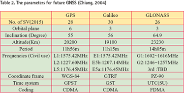
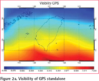
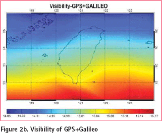
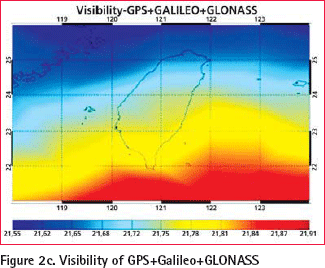
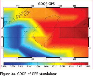
Multi-constellation GNSSBased on the system parameters given previously, future GNSS is expected to provide at least nine frequencies with more than eighty satellites when all the systems become fully operational. Table 2 illustrates the parameters for future GNSS by year 2015. It can be seen from the above descriptions that the next generation GNSS will bring signifi cant improvements compared to current systems. In ten years time there may be as many as 80 satellites from GPS, GLONASS, and Galileo, broadcasting a variety of signals and codes by suitably equipped users for a range of navigation and positioning applications. The L1 signal alone is suffi cient for many massmarket applications requiring an accuracy of (say) 3 to 10 meters. The availability of many more satellites will enable new applications in areas where the current lack of satellites has been a hindrance to market growth (Rizos, 2005). More Satellites to Users Simulation studies were carried out in order to determine the improvements to regional satellite visibility and dilution of precision (DOP) for a combined GPS/GLONASS/Galileo system. The analyses are based on the GPS, GLONASS and Galileo satellite coordinates and given receiver coordinates. The GPS satellite coordinates were determined by using actual ephemeris (converted from the almanac fi les). The nominal constellation for the complete GLONASS as described in the GLONASS Interface Control Document was used (Lachapelle, 2002). The Galileo constellation was compiled from information in Dinwiddy et al. (2004). The implemented GLONASS constellation was essentially 24 satellites in three orbital planes whose ascending nodes are 120° apart. 8 satellites are equally spaced in each plane with argument of latitude displacement 45°. The orbital planes have 15° argument of latitude displacement relative to each other. The satellites operate in circular 19100km orbits at an inclination 64.8°. The Galileo constellation comprises 27 operational satellites in a Walker constellation with three orbital planes, equally spaced with a 56° nominal inclination and an altitude of 23222km. Each orbital plane contains nine satellites, nominally 40° apart and one spare. Simulations have been performed as though the complete GLONASS and Galileo systems were operational at the time of the GPS almanac validity. The simulated measurements are based on a single-frequency point positioning scenarios commencing at 00h 3 August 2006. The span of the simulation was 24 hours. The satellite visibilities for the GPS, GPS/Galileo and a combined GPS/GLONASS /Galileo system with a masking angle of 10° around Taiwan are shown in the Figure (2a), Figure (2b), and Figure (2c), respectively. The combined system indicates an average of about 21 visible satellites over the 24 hour period. At the time of the simulations the GPS has an average of about 7 visible satellites. The GPS and Galileo combined constellations offers on average 15 visible satellites. General speaking, the number of satellites decreases when the latitude of the user increases. In other words, users in southern Taiwan tend to have better satellite visibility than those who in northern Taiwan. Similarly, Figures (3a) to (3c) illustrate the regional GDOP distribution for the GPS, GPS/Galileo and a combined GPS/GLONASS /Galileo system with a masking angle of 10° around Taiwan. The averaged GDOP levels of the dual system are improved approximately 60% of the levels for the standalone GPS scenario. In addition, the averaged GDOP levels of triple systems are improved approximately 80% and 20% comparing to GPS and GPS/ Galileo systems, respectively. Figures (4a) to (4c) illustrate the distribution of localized visibility at the Tainan City (λ=120, φ=23) against raising masking angles (10o, 20o, 30o, and 40o). Similarly, Figures (5a) to (5c) illustrate the distribution of localized GDOP at the same location against varying masking angles. Figures (4) and (5) indicate that the availability and reliability in the urban environment are improved with the increasing number of satellites, therefore, both surveying and navigation communities will fi nd the signifi cance of future GNSS. |
||||



 (No Ratings Yet)


