| Education | |
Standards, challenges and prospects of geomatics education in Sri Lanka
With the evolvement of new technologies and new opportunities enabled surveyors to broaden their skills and competencies |
 |
|
 |
|
History and current status of the geomatics education in Sri Lanka
In Sri Lanka, land surveying and geomatics related activities are officially commenced after the establishment of the Sri Lanka Survey Department (SLSD) which has been founded by a governor’s proclamation dated August 02, 1800, just four years after the British occupied the island’s coastal sector; as a result, the Sri Lanka Survey Department is the oldest civil state department in the nation.
On October 20, 1896, the Govt. Technical College in Colombo, Sri Lanka, began the first systematic training program for surveyors. Later, departmental officers took over the training. Due to this, in 1912, the Sri Lanka Survey Department established its own training facility in Modara, with the practical training taking place in Padukka, which is located closer to Colombo. The training school moved to its current site in Diyatalwa, Sri Lanka, in 1924. The United Nations Development Program (UNDP) helped to improve it in 1968, and an Act of Parliament No. 21 of 1969 founded the Institute of Surveying & Mapping Diyatalwa (ISMD). Initially, the training activities were purely confined to the training of surveyors for Survey Department, and later has gradually taken over almost all the basic training needs of the Survey Department and some other organizations at their request. In 1990, the ISMD was upgraded as a degree awarding institute by a gazette notification No. 620/4 under the section 25A of the Universities Act No. 16 of 1978. Again, UNDP played a prominent role by making necessary funds to strengthen ISMD physically. Since then, the ISMD conducts a four-year degree course in Surveying Sciences in addition to diploma courses for the government surveyors.
The Faculty of Geomatics (FOG) was established in 2004 as one of the nine faculties of the Sabaragamuwa University of Sri Lanka (SUSL). It is the successor to the Department of Surveying Sciences, which introduced the Bachelor of Science in Surveying Sciences degree Programme in 1997. This was the first time in the history of Sri Lanka’s university system that a university established a degree program in this scientific field, meeting a pressing demand for the nation. The Degree Programme is a four-year course leading to an honours degree in Surveying Sciences, subsequently becoming the first such degree awarded in Sri Lanka under the purview of the University Grants Commission (UGC). Currently the faculty offers five specialization programmes: Surveying and Geodesy, Hydrographic surveying, Land management, Remote sensing, and Geographic information systems (GIS).
The General Sir John Kotelawala Defence University (KDU) of Sri Lanka-Southern Campus has also initiated a Surveying science degree programme under the Department of Spatial Sciences covering all the aspects of Spatial Sciences such as Land Surveying, Hydrographic Surveying, Remote Sensing, GIS, Photogrammetry, Cartography, and Construction Surveying in 2015.
National standards of Sri Lankan degree programmes
According to the UGC standard, a student’s program of study is an independently recognized curriculum they follow that helps them qualify for a degree from a given organization. The term “courses/modules” refers to the formalized, self-contained elements that make up a curriculum. Academic programs of study should reflect the mission, aims, and goals of the university or HEI. They are provided in accordance with a needs analysis based on an examination of already offered courses and programs, market research, industry liaison, national and regional priorities, and established procedures. When creating the structure and content of a new degree program, Subject Benchmark Statements (SBS) and professional body criteria serve as helpful external reference points. Students are given the knowledge, abilities, and attitudes necessary to excel in the workplace and in lifelong learning through a curriculum that is outcome-driven (PR manual, 2015).
Beginning with a description of the program’s graduate results, the course/ module outcomes are then directly mapped to the program outcomes. The Sri Lanka Qualification Framework (SLQF) is used to establish and explain learning outcomes in relation to a specific level of study. Every program’s objectives must to be explicitly in line with the course’s objectives, content, teaching/ learning methods, and evaluation techniques (constructive alignment). In order to establish compatibility between the curriculum, studentcentered teaching strategies, and assessment processes, programs should aim to involve students in a variety of learning activities. These activities should encourage diversity, flexibility, accessibility, and autonomy in learning. The final curriculum is essentially the result of interactions between learning objectives, evaluation techniques, instructional strategies, and content.
Sri Lanka Qualification Framework (SLQF) and subject benchmark statement in geomatics
Recent years have seen a substantial gromobility of lwth in the earners and educators between nations and regions of the world, necessitating the support and adaptation of national higher education institutions. Considering this, the Sri Lanka Qualifications Framework (SLQF) is a significant component of the development of systems in the higher education sector. It provides a clear and consistent framework for the learner to optimize his or her goal of learning throughout life, while also enhancing many essential aspects of learning and evaluating the learning process. The SLQF’s establishment will contribute to various improvements in learning processes and aspects. Additionally, it will raise the standard of education in the country while simultaneously offering a clear method for establishing connections with higher education institutions outside.
The SLQF serves as a uniform national foundation for all higher education credentials provided in Sri Lanka. All higher education institutions (HEIs), including public and private, that offer post-secondary education are subject to the SLQF. It acknowledges the amount of learning that students have done and lists the learning objectives that certification holders must meet. The SLQF consists of twelve levels, and each level’s descriptors are fully stated (Table 1). SLQF contributes significantly towards strengthening quality assurance mechanisms of the entire higher education sector in Sri Lanka.
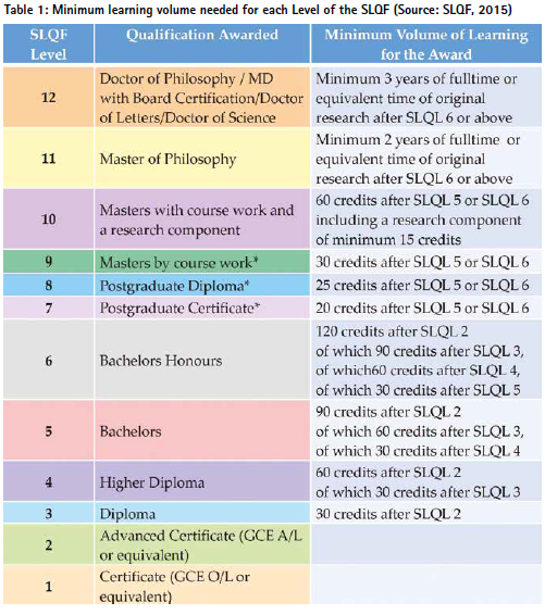
Since SLQF is a nationally consistent framework for all higher education qualifications offered in Sri Lanka and applies to all higher education institutions, All Geomatics degree programme have adopted SLQF guidelines. Also, SLQF implementation is a must to get UGC recognition and accreditation for the degree programmes. In general all the four year degrees are placed under SLQF level 6.
Further, the UGC has developed the Subject Benchmark Statement (SBS) for each of the degree programme including Geomatics with a wider stakeholder participation in 2010 through the Quality Assurance and Accreditation Council (QAAC) of UGC. Subject benchmark statement is an essential component of quality assurance in the university system. This statements support to the academic community to describe the nature and characteristics of a specific subject or subject area (SBS Geomatics, 2010).
The role of professional institutions in higher education
In general, important stakeholders in higher education are students, alumni, employers and faculty members. However, when referring key stakeholders of higher education in professional degree programmes, professional bodies play an important role. Professional bodies contribute: creating high quality graduates with appropriate balance between practical experience and theoretical knowledge; making relationship between professional bodies’ requirements and university curricula; minimizing the risk of having low or high entry to a certain profession related to areas to the profession or to the quality of the students; providing internships or apprenticeships; and identifying the additional skills required by the qualification such as soft skills including communication, IT or socalled transferable skills. Therefore, professional bodies can contribute to the teaching and education performance for better skilled graduates at universities which become learning organizations of their programmes and current in targeting market needs. As a whole, role of professional bodies to contribute to higher education can be broadly categorised as
: • Providing input towards up to date programs
• Acting a pro-active stakeholder engagement to the market and its needs. New trends in the profession, new market.
• Observing theoretical knowledge, practical knowledge and required professional skills
• Implementing the challenges in the market, ethical practices and codes of conduct
• Maintaining transparency through the involvement of professional bodies.
When it comes to professional bachelor’s degrees like Geomatics, these programs generally have a different structure than a common Bachelor of Science program, because these professions are regulated by the relevance professional bodies and most of these curricula is focused on the practical training aspects and professional ethics. Therefore in producing graduates in a Geomatics requires an exclusively planned curriculum addressing the prevailing professional requirements. Therefore, the faculties have appointed the officers from the respective local professional bodies as advisors in various committees such as course advisory committees to obtain their valuable inputs as well as time to time obtaining the feedbacks from them including the other stakeholders.
Importance of local and global accreditations
As the universities began awarding the Geomatics degrees, it is not restricted to cater the local demand. This has opened a new door to cater the international market while fulfilling the local professional requirements as well. Currently all the Geomatics related degrees awarded in Sri Lanka fulfil the basic academic requirements as laid down by the Survey Act 2002. The qualified graduates have acquired the professional membership in the SISL and licensing from the LSC after proving their substantial professional experience after graduation.
Apart from that, the international accreditation enhances the recognition of a degree worldwide. It assures employers, academic institutions, and other stakeholders that the graduate has received education of a certain standard, making it easier for them to trust the qualifications. This ensures better employability opportunities and better pays. Overall, both local and global accreditations play a crucial role in validating the quality and integrity of degrees, providing assurance to students, employers, and to the society at the end.
Global and local professional bodies involved in geomatics education in Sri Lanka
The Surveyors’ Institute of Sri Lanka (SISL) is the National Professional Body of the Surveying Profession. It is also a Founder Member of the Commonwealth Association of Surveying & Land Economy (CASLE) and the Organisation of Professional Associations (OPA). Further, it is also a Member of the International Federation of Surveyors (FIG). The Parliament Act No. 22 of 1982 incorporated the Institute (Surveyors’ Institute Sri Lanka (Incorporation) Act).
According to the Survey Act No. 17 of 2002 of Sri Lanka, Land Survey Council (LSC) has been established as the governing body to regulate the professional conduct of surveyors. According to this acts, both SISL and LSC, are responsible for supporting and standardizing the professional education of Surveying in Sri Lanka. As one of the duties of LSC, it is responsible for recognising the academic and professional qualifications in land surveying (Survey Act, 2002). This is important for benchmarking and standardizing the degree programmes since there are few institutions which offer geomatics related degree programmes. For any professional degree programmes, there should be essential components to be included in their curricula. These fundamental course modules to be decided by the discussion and agreement of respective professional bodies.
Beside the local professional bodies, the education institutions have also considered some important elements from international professional bodies such as Royal Institution of Chartered Surveyors (RICS). At the moment, Faculty of Geomatics is having the RICS accreditation for all of its specialisations as well as its Hydrographic specialisation has obtained the FIG/IHO/ICA Category B recognition from International Board on Standards of Competence for Hydrographic Surveyors and Nautical Cartographers (IBSC) since 2015. These remarks clearly indicate that the Faculty of Geomatics, Sabaragamuwa University of Sri Lanka has become a world-class degree awarding institution in the field of Geomatics and Hydrography in this part of the world.
Future pathways of Geomatics Education
With the evolvement of new technologies and new opportunities enabled surveyors to broaden their skills and competencies than they were traditionally involved as the surveying profession moves into the 21st century. These led to several challenges in defining the boundary of the profession. Today it is so much diversified by encompassing various other activities such as real estate management, digital image processing and Artificial Intelligence (AI), engineering design, planning & decision making, space navigation, Big Data, Geo statistics, etc. The Royal Institution of Chartered Surveyors defined some 11 mandatory competency aspects, 13 core competency aspect areas and another 10 optional competency areas leading towards almost over 100 specific technical competencies which requires at various levels of its membership (RICS, 2018). This implies that modern surveying programmes must be developed into multitalented professional people capable of handling large data and AI based smart solutions. Therefore, the curriculums must be revised by incorporating such future trends in order to produce Geomatics graduates to thrive in the future job market.
References
Manual for review of undergraduate study programmes of Sri Lankan universities and higher educational institutions, 2015, University Grants Commission, Colombo 7, Sri Lanka.
Sri Lanka Qualifications Framework, 2015, University Grants Commission, Colombo 7,
Sri Lanka. Survey Act No. 17 of 2002, Sri Lanka.
Pathway Guide – Geomatics, Royal Institution of Chartered Surveyors, August 2018.
SBS-Geomatics, 2010, UGC QAAC. https://www.eugc.ac.lk/qac/downloads/ SB/SBS-Geomatics.pdf


 (1 votes, average: 4.00 out of 5)


Leave your response!