| Geodesy | |
SIRGAS — a geodetic enterpriseL
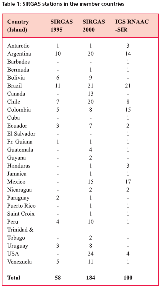
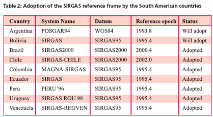
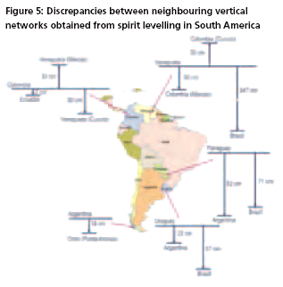
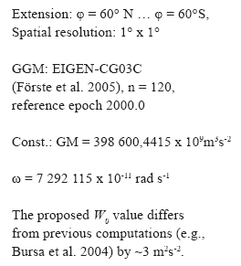
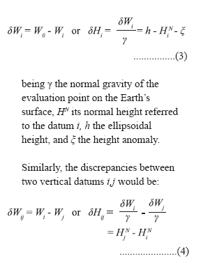
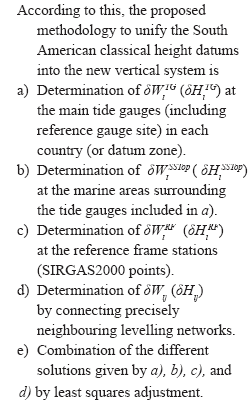
Working Group II: Geocentric DatumThe objectives of the WGII are – to defi ne, realize and maintain the geodetic datum in the member countries consistent with the SIRGAS reference frame (see WGI), – to promote the connection and transformation of the national geodetic networks to the geocentric datum, – to support the definition, realization and adoption of a unified vertical reference system in the member countries (see WGIII), The realization of the objectives is done using the SIRGAS stations in each country as a national reference frame. These are the stations included in the GPS campaigns 1995 and 2000 as well as the continuously observing GPS receivers of the IGS RNAAC-SIR. The present status of those sites is given in Table 1. Some countries adopted officially the SIRGAS reference system soon after the first campaign in 1995 and derived transformation parameters from the old geodetic datums to SIRGAS. Others are still in the procedure of adoption. The reference epoch is different due to the adopted coordinates of SIRGAS95 or SIRGAS2000, respectively. Table 2 shows the status in December 2005. Working Group III: Vertical DatumThe classical height systems in South America were established using the mean sea level as a reference level. Their realization was carried out by 10 to 20-year observations at individual tide gauges over different periods. The vertical control was extended over each country using mainly spirit levelling methods, but in general the levelled heights have not been corrected by the gravity effects. Therefore, these systems present large discrepancies between neighbouring countries (Figure 5), they do not permit data exchange neither in continental nor in global scale, and they are not able to support practical height determination with GNSS techniques. The unique alternative is to define a new vertical reference system that solves the mentioned problems, allows its continuous improvement and serves as a complement to the geometrical SIRGAS system. With this purpose, during the IAG Scientific Assembly held in Rio de Janeiro in 1997, the Working Group III “Vertical Datum” was created. The main objectives of WGIII are to define a modern unified vertical reference system for South America, to establish the corresponding reference frame, and to transform the existing classical height datums to the new system. According to its recommendations the new vertical system is composed by (Drewes et al. 2002): – Two types of heights: normal heights as a physical component, and ellipsoidal heights as a geometrical component, – the corresponding reference surfaces: the quasigeoid for the normal heights, and the ellipsoid for the ellipsoidal heights, – a reference frame, i.e., a set of fundamental stations to realize it, and – its maintenance through time to control its possible deformations. The realization of this new vertical system was carried out by theSIRGAS2000 campaign (Figure 2). It covered the stations of SIRGAS95, the principal tide gauges of the participating countries, including those serving as reference for the classical height datums, some stations at the borders to connect the levelling networks between neighbouring countries and additional primary vertical control points (Luz et al. 2002). The stations shall be connected by spirit levelling with The geometrical component of the new vertical system has been accomplished by adopting the SIRGAS system as thecial geodetic reference frame in the South American countries The ellipsoidal heights refer to the SIRGAS datum, i.e., the GRS80 ellipsoid (SIRGAS 1997). The realisation of the physical component (normal heights and quasigeoid) implies, among others, the computation of geopotential numbers in a continental adjustment, the determination of aunified quasigeoid model for the region, and the transformation of the existing height systems to the new one. Regarding the first task, the countries have been requested to control their first order levelling networks, to check the existing gravity data, and to calculate geopotential numbers. The second task, the quasigeoid computation, must be performed jointly by all countries using global gravity data from the satellite missions (CHAMP, GRACE) and terrestrial (aerial and marine) gravity measurements. The new adjustment of the first order levelling networks in terms of geopotential numbers is to remove the existing inconsistencies due to omitting the Earth’s gravity field effects and the constraints of the vertical networks by forcing more than one tide gauge to zero height. To get a minimum constraint solution only one geopotential value (W0 ) shall be used as reference level for the adjustment of the entire continentallevelling network. Although W 0 can be arbitrarily selected (e. g., the-actual or theoretical- equipotential surface passing through a specified tide gauge mark, or the average of the potential values at different tide gauges, or along the coast line) WGIII recommends the adoption of a globally defined reference level. It should follow the Gauss-Listing definition, i.e., W0 shall be the geopotential averaged over the global (ideal) ocean surface in a totally undisturbed state: the geoid (Mather 1978). Since geoid and quasigeoid are identical in oceanic regions, it is not necessary to distinguish between these two surfaces to determine W0 . According to above, W 0 has been calculated using different mean sea surface (MSS) models and diverse global gravity models (GGM) (Sánchez 2005) by means of (e.g. Torge 2001): The reasons for this disagreement are being studied. The unification of classical height datums into a global system isfeasible by combining high resolution gravity field models, precise geometrical coordinates, and physical heights derived from levelling and terrestrial gravity data. The relationship between the global reference level W0 and the local height datums Wi (Figure 6) is given by (e.g., Rapp 1994, Heck 2004): |




 (No Ratings Yet)


