| Geodesy | |
SIRGAS — a geodetic enterpriseL
|
||||
SIRGAS (Sistema de Referencia Geocéntrico para las Américas) is a joint project of South, Central and North American countries in cooperation with some international institutions for the establishment and maintenance of a geocentric reference frame for practical and scientific use. A unique reference frame for the American continent was established by two extremely successful geodetic observation campaigns, SIRGAS95 and SIRGAS2000. It provides the basis for the requirements of modern geodesy, and is one of the most important enterprises within geodetic science. At present, its goals aim at the complete integration of all American countries, the maintenance and processing of a continuously observing stations network in the continent, and the adoption of a unified vertical system (height datum). The general outlines for the future tasks are presented in this paper.
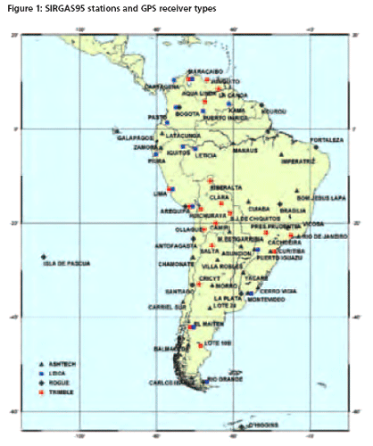
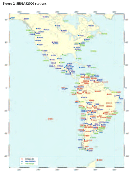
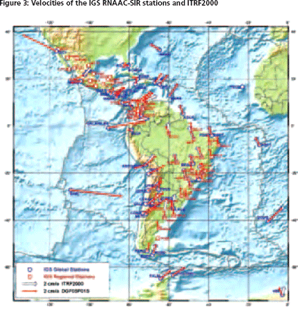
SIRGAS history, structure and present situationSIRGAS was established during an international meeting in Asunción, Paraguay, in October 1993 by representatives of most of the South American countries, the International Association of Geodesy (IAG), the Pan American Institute of Geography and History (PAIGH), and the National Imagery and Mapping Agency (NIMA), now National Geospatial- Intelligence Agency (NGA), as the “Sistema de Referencia Geocéntrico para América del Sur” (South American Geocentric Reference System) Project. The main objectives were – to define and establish a geocentric reference system for the continent, – to define and establish ageocentric datum, – to define and establish a unifi ed vertical datum. The project structure includes an Executive Committee, made up by the representatives of all participating countries and international institutions, a Directive Board, a Scientific Council, and three Working Groups: WGI “Reference Systems”, WGII “Geocentric Datum”, WGIII “Vertical Datum”. The objectives, responsibilities and activities of each of these entities are established by the Project Statutes, which have been approved in 2003. In 2000 the project was extended to Central and South America. As a consequence it was renamed “Geocentric Reference System for the Americas” keeping the acronym SIRGAS. In 2001 the United Nations Regional Cartographic Conference for the Americas (UNRCCA) recommended the countries in the region to adopt SIRGAS2000 as their national geodetic reference frames. Working Group I: Reference SystemThe objectives of WGI are clearly stated by the SIRGAS statute and encompass the definition of a tridimensional geocentric reference system for the Americas, as well as its realization and maintenance through a reference frame materialized by a set of stations coordinates and velocities. The first SIRGAS observation campaign was performed from May 26th to June 4th 1995. A total of 58 stations in the South American continent and neighboring areas were measured simultaneously by GPS observations (Figure 1) establishing one of the most precise continental geodetic networksall over the world. The observations were processed by two analysis centers at DGFI, Germany, and DMA, USA and combined for a unique solution in the International Terrestrial Reference Frame 1994 (ITRF 94), reference epoch 1995.4. The precision of threedimensional coordinates is about ± 5 mm for each component. The final results were reported at the IAG Scientific Assembly in Rio de Janeiro, August 1997 (SIRGAS 1997). The second SIRGAS observation campaign was performed from May 10th to 19th 2000. In South America 56 points of the first campaign were measured again. The network was densifi ed in some countries and extended to Central and North American countries by 85 new stations. In addition 43 points at tide gauges were included in order to connect the existing height datums to the geocentric reference system. Altogether the network consists thus of 184 stations all over the American continent (Figure 2). The data were processed by three processing centers at IBGE, DGFI and the Bavarian Commission of Geodesy (BEK), Germany. The final combined station coordinates refer to ITRF2000, reference epoch 2000.4 (Drewes et al. 2005). In the meantime, a network of continuously operating GPS receivers has been installed by SIRGAS in Central and South America. It is operational since 1996 and nowadays involves more than 80 stations. The Regional Network Associate Analysis Center (RNAAC) for SIRGAS – one of the regional analysis centers belonging to the International GNSS Service (IGS) – computes the network coordinates and velocities (Seemüller 2004). A set of station coordinates iscomputed every week. Linear station velocities are derived by accumulating several years of weekly solutions, the latest including all data up to end of 2005 (Figure 3). The DGFI is in charge of processing the IGS RNAAC-SIR. A station velocity field was derived by finite element and least square collocation approaches (Figure 4, Drewes and Heidbach 2005) from the SIRGAS coordinate changes 1995 to 2000, the continuously observing GPS stations of the IGS RNAACSIR, and the geodynamics projects Central and South America (CASA), South America – Nazca Plate Motion Project (SNAPP), Central Andes Project (CAP), and South America Geodynamic Activities (SAGA). As a result of the SIRGAS WGI activities, the Americas have gota geocentric reference system materialized in accordance with the uppermost geodetic standards. SIRGAS satisfies the highest demands of modern geodesy and provides the fundamental layer for America’s Spatial Database Infrastructure. A WGI action plan for the coming years was discussed during the SIRGAS meeting, held in Aguascalientes, Mexico, December 2004. The general consensus was to drive WGI efforts toward the consolidation of the SIRGAS network of continuously operational GPS stations as the cornerstone for the reference frame maintenance. The following issues were appointed as WGI priority: – to improve the performance of presently operational stations, – to improve data transfer to data centers,- to encourage and to support the installation of new stations, and – to install processing centers in American countries. In addition, the SIRGAS executive committee encouraged WGI for conducting a pilot project on ionospheric mapping in South America, based on dual-frequency GPS observations belonging to the continuously operational SIRGAS network. A cooperative project between Brazilian and Argentinean universities, aimed to regional ionosphere mapping, is currently being discussed. The first assignment for accomplishing the action plan was to identify the main problems that affect the network performance. These problems may be summarized as follows: – Difficulties for data accessing on time (within three weeks after observation), – Lack of information about changes in the observing configuration (receiver, antenna, antenna height, etc.), – Lack of information about the reason for no data, – Lack of information about new stations in the IGS RNAAC-SIR region, – Bad or very slow internet connections, and – No data transfer during the South American vacation period (December and January). Actions for mitigating these problems are currently being discussed by WGI. WGI is conducting a pilot project to establish processing centers in the region, to carry out a task analogous to that currently performed by the IGS RNAAC-SIR. Preliminary, the UNLP, Argentina, the IBGE, Brazil, and INEGI, Mexico, were identified as potential candidates to carry out this task. These institutions agreed to compute different parts of the network and to deliver normal equations from their weekly solutions to DGFI. During a test period of two years DGFI will continue to be in charge of the IGS RNAAC-SIR. |
||||


 (No Ratings Yet)


