
| Applications | |
Remote sensing and GIS applications for assessing urban expansion effects on protected areas in Sub-Saharan Africa
During this review was that most of research that involved the application of GIS and RS in urban sprawl monitoring seemed to be concentrated within a few countries |
|
|
|
|
Abstract
Urban Sprawl in Sub-Saharan Africa presents growing risks to biodiversity and protected areas. Over recent years, there has been a notable increase in population within urban areas across the Sub-Saharan Africa (SSA). This demographic shift has precipitated urban sprawl, thereby escalating the demand for land. Urban sprawl facilitates the emergence of informal settlements, which are characterized by development that does not comply with urban planning policies, zoning regulations, and other pertinent legal frameworks. Urban sprawl poses a threat to the integrity of protected areas by altering ecosystems through disturbances caused by human presence and activities. It presents significant challenges for conservation efforts, notably through habitat and biodiversity loss, pollution, and the presence of weak regulatory frameworks. In addition, its ecological impacts on nature reserves are often unrecognized by the public due to a lack of awareness. It is important to study and map urban sprawl patterns over time using remote sensing (RS) and Geographic Information Systems (GIS) technologies to support evidence-based solutions for addressing urban sprawl in SSA while promoting a balance between urban development and environmental conservation. Despite the demonstrated utility of RS/GIS technologies, their application remains uneven across the region. This systematic review synthesizes empirical research applying RS/GIS to evaluate the impact of an expansion on biodiversity within SSA’s protected landscapes. The findings revealed consistent reliance on medium resolution satellite imagery and supervised classification techniques to detect patterns of encroachment, green space reduction and habitat degradation. The review furthermore underscores the importance of implementing environmental education programs targeted at urban and periurban communities to encourage participatory approaches that involve community members in the management of nature reserves, including local stewardship programs, co-management initiatives, and educational outreach programs, as the management of nature reserves encompasses not only spatial planning issues but also broader policy challenges.
1 Introduction
Urban Sprawl is widely recognized as a complex concern that poses significant threat to biodiversity and ecological integrity, particularly in rapidly urbanizing regions such as Sub-Saharan Africa (SSA). The definition of urban sprawl is often debated by urban planners and environmentalists, however the generally accepted definition is “the uncontrolled growth of urban areas into surrounding natural and agricultural lands” [21]. In developing regions, it’s characterized by low-density buildings, increased dependance on automobiles, land use conversion and environmental degradation [3]. It’s caused by factors such as economic growth, population growth and regional disparities in development [51, 54]. With the rapid increase in human population, many regions within Sub-Saharan Africa have had their natural ecosystems threatened [30]. Between the years 1990 and 2014, urban sprawl increased by 95% at a global scale [31].
Urban Sprawl has been widely studied due to its environmental and socio-economic consequences globally. In their study, Sen [45] concluded that urban expansion leads to habitat degradation, loss of biodiversity and land-use conflicts. Despite the implementation of mitigation strategies such as urban edging, the challenge persists in the region [30]. While the physical manifestation of urban sprawl is the most visible aspect, it is important to view it as a multidimensional phenomenon because its consequences extend beyond simple landcover change Zhang, L & Shu [61]. The socioeconomic impacts of urban sprawl in the SSA are evident through the facilitation of informal settlements development that lack basic services and development space. These are areas developed without adherence to urban planning policies, zoning regulations and other legal frameworks applicable such as securing appropriate permits for developments [28]. As a result, the environmental aspect suffers through factors such as the introduction of environmental pollution [27]. Pollution from the informal settlements results mostly from improper waste management contributing to water contamination and soil degradation [24]. Furthermore, services such as pollination, water movement and infiltration and carbon sequestration are further impacted by the sprawl [24, 27]. Effective monitoring systems for quantifying impacts and informing evidence-based management are needed to prevent nature reserves losing their ecological integrity.
GIS and remote sensing technologies can provide effective monitoring functions/capabilities that will allow for a balance in growth of development and conservation in developing regions [35]. According to Parra [41], the integration of remote sensing (RS) and Geographic Information Systems (GIS) in environmental monitoring represents a critical advancement in addressing complex challenges that are posed by rapid urbanization. Urban expansion is a major global driver of land-use change, with significant implications for biodiversity and ecosystem functions (Seto et al. 2012; Angel et al. 2021). Cities in Sub-Saharan Africa (SSA) are expanding at an unprecedented rate, often outpacing global averages, and this growth is taking place in environments with limited planning capabilities, expanding informal settlements, and lax enforcement around protected areas (Li et al., 2022); [50]. Nature reserves and conservation corridors are becoming more vulnerable to habitat loss, fragmentation, and edge effects, which jeopardize their long-term ecological health [49, 53]. Satellite observations and geospatial information systems have become very important tools for tracking these impacts due to their accurate, multi-decade views of the earth that allow us to monitor land cover changes, impermeable areas, and vegetation state changes [29, 57]. Using satellite data for free, particularly Landsat and Sentinel-2, along with sophisticated analytical methods, such as machine learning, object-based analysis, and time-series change detection, has improved the evaluation of urban encroachment on protected areas in Southern Africa [18, 23, 43].
In the developing SSA countries where urbanization is happening at unprecedented rates, these technologies provide essential capabilities for quantifying, tracking and analyzing the impacts of urban sprawl in protected natural landscapes [32, 34]. Through satellite imagery, spatial analysis and detection of change over time, we can now efficiently monitor how the landscape has transformed over time.
Despite advancements, the application of remote sensing technologies to examine urban-nature interactions in Africa remains largely unexplored from a holistic perspective. Existing reviews often highlight global patterns or focus on urban areas in the Global North, offering only a limited synthesis of evidence pertinent to the unique ecological, socio-economic, and governance contexts of SSA [59], (Darko et al. 2023). This gap is significant because urban expansion in SSA is typically characterized by the rise of informal settlements, uncontrolled peri-urban development, and the encroachment of agricultural land, which differs from the scenarios in wealthier regions, necessitating context-specific analytical approaches. While remote sensing and GIS have been used to monitor urban sprawl and land cover change in the SSA, there is still a gap in reviews that specifically focus on their application in assessing the impacts of nature reserve in this region. This review will highlight how remote sensing and GIS have been applied to monitor and assess the impacts of urban sprawl on biodiversity within nature reserves in Sub-Saharan Africa (SSA) using existing studies, and identify the key methodological trends, gaps and future research priorities. It will contribute to existing literature by synthesizing recent applications RS and GIS in assessing the ecological implications of urban sprawl on protected areas in SSA. The region remains underrepresented in global spatial research and most reviews focus on urban expansion or technical methods alone. This review aims to fill this gap by putting an emphasis on biodiversity and habitat implications of urban sprawl. In addition to clarifying the situation, the review will facilitate evidence-based management of protected areas vulnerable to rapid urbanization.
2 Methodology
2.1 Literature search method
A comprehensive systematic literature review was conducted in accordance with the PRISMA 2020 statement to synthesize existing research. This methodological approach ensures a transparent, reproducible, and extensive synthesis of the literature, distinguishing itself from traditional narrative reviews by employing explicit, predefined procedures to mitigate bias and provide an authoritative overview of the subject matter. The designated protocol aimed to address the primary research question: “To what extent have remote sensing and Geographic Information Systems been utilized to investigate and evaluate the consequences of urban sprawl on biodiversity within nature reserves in Sub-Saharan Africa?” This study employed a systematic approach to gather and review literature on the use of remote sensing and Geographic Information Systems (GIS) in monitoring the impacts of urban sprawl on biodiversity within nature reserves.
Academic databases such as Science Direct, Google Scholar and Scopus accessed through Cape Peninsula University of Technology’s library were used to search for research papers, reports and published thesis. The search strategy used a combination of keywords that focused on three concepts. For urban Sprawl, the terms included (“urban sprawl” OR “urban expansion” OR “urbanization”). For technology, the terms used were (“remote sensing” OR GIS OR “geographic information system**” OR “satellite imagery”). Lastly, for the subject & location, (“nature reserve” OR “protected area” OR “national park**” OR biodiversity) AND (“Sub-Saharan Africa” OR SSA were used.
2.2 Eligibility and exclusion criteria
Study selection was based on the following predefined criteria: Population/Subject: Nature reserves, protected areas, or wetlands of ecological significance within Sub-Saharan Africa. Intervention/Technology: For spatial analysis, studies must make explicit use of remote sensing technologies (e.g., Landsat, Sentinel, SPOT) and Geographic Information Systems (GIS). Results: Studies should evaluate changes in Land Use/Land Cover (LULC) and correlate these changes with impacts on biodiversity, habitat quality, or ecosystem integrity. Study Type: Empirical, peer-reviewed journal articles, conference proceedings, and doctoral theses. To ensure a contemporary review covering 15 years at the time of writing, studies published prior to 2008 were excluded. Studies that were not written in English were also excluded. Additionally, review articles, editorials, and opinion pieces were not considered, although their reference lists were examined for potential sources. Studies employing RS/GIS that did not explicitly link urban sprawl to biodiversity impacts within or adjacent to a protected area were also excluded. An article with the full text that is not available through the institution’s access or the author’s request for access.
2.3 Selection of studies and data extraction
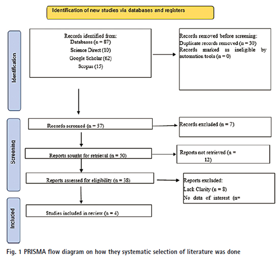
Out of the 87 papers that were initially identified, 54 papers were eventually excluded. Despite having the key words of interest in their titles, they lacked data of interest therefore only 4 were considered to be relevant in the context of Sub-Saharan Africa and were used to inform this review (Fig. 1). The study selection process followed the PRISMA 2020 flow diagram. Figure 1 below is a PRISMA Flow Diagram, documenting all stages from identification to final inclusion. A total of 4 studies met all inclusion criteria and were included in the final synthesis. During the selection of literature and extraction of data, priority was given to papers that specifically analyzed and examined the application of remote sensing and GIS technologies in assessing urban sprawl and its effects on biodiversity or habitats. Emphasis was also placed on research that has been conducted in Sub-Saharan Africa. From the included studies, the data that was extracted was organized and analyzed to identify common patterns and trends. Moreover, building on the reviewed literature, this study further emphasizes the paucity of research undertaken in Sub-Saharan African (SSA) countries and examines the existing research structure and emerging trends in the application of remote sensing and GIS to monitor the effects of urban sprawl on nature reserves. A systematic search in the Web of Science database, using the key terms “urban sprawl,” “remote sensing,” “geographic information system,” and “Sub-Saharan Africa,” yielded numerous publications globally.
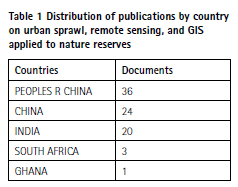
Using the Web of Science database, an initial bibliometric analysis was conducted to gain a deeper understanding of global research on urban sprawl and the application of remote sensing (RS) and Geographic Information Systems (GIS). Sub-Saharan Africa-specific inclusion criteria were then applied. Table 1 illustrates the distribution of publications by country from this initial global search based on a predefined search syntax combining urban sprawl, RS/GIS technologies, and protected or conserved areas. Researchers in Sub-Saharan Africa do not contribute much, with only a few publications coming from South Africa and Ghana. The findings indicate that research output is heavily concentrated in a few countries, primarily China and India. China’s dominant position in the dataset is due to differences in how database country affiliations are indexed, emphasizing the global imbalance in research focus.
Nonetheless, this table emphasizes the importance of regional studies rather than simply shifting the geographical focus of the review to Sub-Saharan Africa, which is underrepresented in global literature.
2.4 Data synthesis and critical analysis method
The data collected were integrated using a mixed-methods approach to provide both quantitative and qualitative insights. A quantitative analysis was conducted through systematic extraction and calculation of descriptive frequencies to identify trends, including the annual distribution of publications, the spatial distribution of case studies, the frequency of use of specific satellite sensors as well as the prevalence of certain classification and change detection methods. Furthermore, a thematic qualitative synthesis using the Babel thematic analysis method was employed to identify, analyze and present themes within data derived from the findings and discussion sections of studies. The primary themes identified were: Methodological Complexity, which encompasses the techniques and tools used for analysis; Ecological Connections, which refers to how research has transformed LULC maps into significant insights into biodiversity (e.g., through fragmentation analysis, habitat connectivity models, or associations with species data); and Policy and Management Significance, which examines the extent to which the research provides findings relevant for conservation planning and governance.
3 Results
3.1 Monitoring urban sprawl using remote sensing techniques
Remote sensing is the art where information about an object, phenomenon or area is obtained without being in direct contact with it [47]. This technology has evolved substantially over the past two decades and has become essential in detecting, monitoring and quantifying the growing environmental challenges, especially in developing countries. Several studies have applied remote sensing technologies to monitor urban sprawl in SSA. A summary of these studies is presented in Table 2.
Recent applications, particularly using Landsat imagery have been effective in mapping and quantifying land use/land cover changes of urban sprawl in the rapidly growing African cities. Figure 2 shows urban sprawl is studied using remote sensing and GIS in Sub-Saharan Africa mainly in West Africa (Ghana), East Africa (Kenya, Uganda, Tanzania), and Southern Africa (South Africa, Botswana), with a strong focus on capturing rural livelihood impacts through integrated methods, change detection techniques, and environmental impacts. The rapid urbanization of these countries makes them ideal research areas for understanding sprawl patterns, particularly in their major cities. Krishnaveni and Anilkumar, [34] highlighted that using high resolution satellite imagery and aerial photography, remote sensing enables precise mapping and classification of land cover over a period of time. Take for instance how Muchelo et al., [37] were able to monitor the associated land use/land cover (LULC) changes in Kampala and Mbarara, Uganda. From the study, the authors revealed a significant change in the land-use evidenced by the transition of agricultural land to built-up areas due to the encroachment of urban cities through the use of multi-temporal Landsat imagery. Their study demonstrates that using remote sensing allows for a visualization of the spatial and temporal changes in urban areas is essential in assisting urban planners and conservationists to track the expansion patterns, detect land conversion and assess the impacts of urbanization on natural environments. This allowed for effective and targeted environmental impact management, ensuring challenges like pollution, migration and reduction of protected natural green spaces are being effectively addressed.
The studies in Table 2 showed consistent use of medium resolution Landsat imagery (30 m) in their analysis. Magidi and Muchelo applied supervised maximum likelihood classification (MLC) to classify the imagery. MLC is a commonly used classification method when classifying Landsat imagery into their relevant land cover classes or uses. Using supervised MLC was advantageous in these studies as high accuracy in classification were reported, especially since training data was available [37]. The usage of this imagery and classification technique was cost effective. The combination of satellite imagery and socio-environmental data provided valuable insights into habitat and biodiversity fragmentation within the study area.
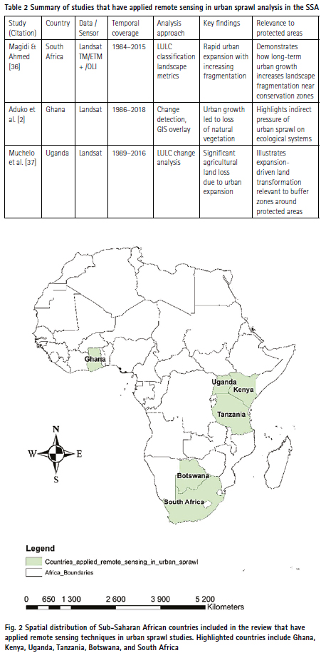
Across the reviewed studies in Table 2, there is a pattern of accelerating urban growth within the cities over the study periods. The common leading driver of the growth was found to be natural and rural to urban migration across the locations. This growth occurs at the expense of natural landscapes that have been either encroached or converted into urban areas. Consequently, the conversion of these natural landscapes has led to biodiversity loss due to the fragmentation of natural habitats. At the time of study, the pattern of acceleration urban growth within the cities indicated that loss of biodiversity was likely to continue well into the future. Moreover, the accelerating growth theme has shown signs of shifting the local economies across the cities, where it was observed that most of the cities are transitioning from agriculture-based economies to service-based economies. This shift further exacerbates urban sprawl due to an increase in economic opportunities that have led to population level increases. All of the authors used freely accessible satellite Landsat data. This usage allowed for repeated systematic monitoring of urban changes during the study periods. Due to the usage of RS and GIS technologies, the authors were able to assess the extent to which urban expansion is occurring, determine the key drivers for it and provide spatial information needed to inform conservation and decision making.
While the studies have yielded significant benefits in assessing urban sprawl patterns and the usage of remote sensing technologies does face some challenges. Remote sensing usually depends on cloud free atmospheric conditions which may limit data availability [35]. In addition, high resolution spatial imagery is preferred but it is costly. Many of these studies rely on medium resolution imagery which may pose a challenge when identifying and classifying mixed land uses. When conducting such studies, it is important that the results are as accurate as possible as they may be used to inform decision making. This common usage of medium resolution imagery may pose a challenge in accuracy as they usually are not detailed enough for small complex features. The complexities of urban landscapes must be considered when using satellite imagery to track changes overtime. Failure in doing so could lead to uncertainties or overlaps data where there’s mixed pixels between the urban and non-urban surfaces [41]. Furthermore, using medium resolution usually leads to shadows from the buildings and trees further complicate the interpretation of these images. This means the results of such studies must be interpreted within some limitations, which may reduce the accuracy of the classification. It is therefore important to invest in ongoing research and technological improvements to address these challenges.
However, these limitations do not dismiss the benefits that are offered by remote sensing when monitoring biodiversity as can be seen in the accurate presentation of urban sprawl patterns within the study regions in Table 2. The consistency of the usage of medium resolution Landsat imagery over a long period of time enabled the quantification of urban expansion and landscape metric changes within the complex urban settings.
3.2 Urbanization trends in Sub‑Saharan Africa
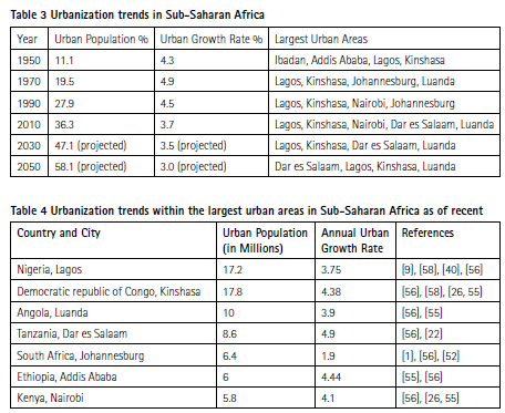
Urbanization in the SSA is driven by a combination of natural population growth, rural-to-urban migration and reclassifying rural areas as urban [11]. Urban areas attract migrants due to job opportunities, better living and housing conditions, education and health opportunities. Many of the settlements within these countries that were historically classified as rural are now being redefined and reclassified due to the partial growth, infrastructural development and the increased population densities [26]. Unlike developed regions where urban rates have stabilized, countries in the SSA must contend with the ongoing development pressure as they are rapidly transitioning into the “urban age”. According to [26]. The spatial expansion of urban land in Africa is expected to increase by nearly 600% between the years 2000 and 2030. While the SSA region is a developing region and the drivers for urbanization are similar, the pace of urban growth and expansion varies from country to country and over different years [44]. When focusing on these trends, it is essential to consider the role factors like the different socioeconomic statuses and governance of the countries play in urban expansion. An overview of urbanization trends and projections across SSA’s countries is summarized in Table 3, highlighting the recorded largest urban areas and their current and projected urban growth and population. These metropolitan cities were consistently identified in this review as the focal points for urbanization in the SSA. The higher the urban growth, the higher the expansion of urban areas within the countries over the years.
Table 4 provides a more detailed insight into the largest urban areas in the Sub-Saharan countries as of 2025. Cities like Kinshasa and Dar es Salaam experience the highest urban growth rates indicating that the countries have two of fastest urban expansion in Africa. The high population and growth rates contribute to the challenges faced by these cities such as inadequate housing, increased transportation reliance and pressure on the ecosystem.
4 Discussions
Nature reserves play a crucial role in preserving biodiversity by providing and protecting habitats for a wide range of species [24, 38]. However, urban sprawl threatens the integrity of these areas by altering ecosystems through disturbances from human presence and activities [24]. As the human population grows, there is an increase in the demand for development space. This subsequently leads to the establishment and expansion of both formal and informal settlements resulting in the encroachment of the human population in undisturbed natural landscapes [15, 33]. Urban sprawling leads to the depletion of critical green spaces and natural habitats, which play a pivotal role in maintaining biodiversity and ecosystem services. Despite Africa being known as a continent that has a rich biodiversity, over recent years it has experienced a decline due to the growth of human population [7].
Africa currently ranks as the fifth highest in terms of urban population, with approximately 13 countries exhibiting potential for significant urbanization over the next three decades [13, 48]. This trend is anticipated to result in a substantial decline in protected biodiversity hotspots. The ongoing reduction of urban green spaces is underscored by the study conducted by Appiah-Opoku et al. [5], which examined the effects of urban sprawl on nature reserves and protected biodiversity hotspots in Sub-Saharan Africa, with a particular focus on Dar es Salaam, Tanzania. The rapid urbanization in Dar es Salaam has precipitated a marked decrease in green spaces and environmentally sensitive areas, declining from 86% in 2000 to 40% in 2021. This reduction is attributed to the significant expansion of informal settlements and built-up areas encroaching upon these spaces.
The researchers also included Luanda, Angola and Accra in their study which also seemed to follow a similar pattern of having a decline in the green spaces while there’s an expansion of development [5, 17]. This loss of green space coverage has significantly reduced habitat availability within these cities and has exacerbated urban environmental problems such as heat islands and pollution which have further stressed the ecosystem [33, 60]. This vulnerability of ecosystems within the nature reserves leads to a degradation of habitats forcing many species to adapt or migrate in search of refuge as they experience reduced food availability and shelter issues [38]. In addition to the study by Appiah-Opoku et al., a similar study was conducted in the Ugandan cities Kampala and Mbarara which show similar results where there was a substantial urban expansion within the city. The study was conducted by Muchelo et al., [37] and they found that a significant proportion of urban growth in both cities encroached onto the green nature reserved spaces over the years which correspondingly led to a decrease in green spaces from 48 to 16% in Kampala and from 40 to 32% in Mbarara over the years. Both these studies highlighted that the rapid urban expansion has led to a decline in the integrity of natural ecosystems. The ecological integrity of the nature reserves is also threatened by the introduction of invasive species (pets) by humans and the increased human activities that result in the illegal exploitation of land. The resulting edge effects weaken even the most well managed nature reserves [37].
Sen, [45] highlighted that urban sprawl in protected areas/nature reserves has not only led to biodiversity loss through habitat destruction, but through the introduction of multiple forms of pollution. In their study, the researchers found that the expansion of urban development’s degrade ecosystems through land pollution resulting from the increased generation of waste and poor waste management. Air pollution from industrial and vehicular emissions harm sensitive plants and alter their growth. Water pollution is also experienced [31], [24, 45]. Polluted surface runs off from the established urban areas and from formal industrial activities introduces contaminants into the surface and underground waterbodies as it flows over land and infiltrates the ground, contributing significantly to the degradation of water quality within these environments [19, 20, 39]. The water containing contaminants such as pesticides, fertilizers or excessive nutrients affect the species that depend on this water for survival, rendering the water ultimately harmful [25]. Noise pollution as well as the increased artificial lighting also disturbs the species, especially the small animals as they are a nuisance. This type of pollution is often neglected, not realizing that it promotes emigration of these animals from the nature reserve [31], [13].
In light of the review’s content, there we highlight challenges posed by urban development in and around conservation areas in Sub-Saharan Africa and an introduction of a novel model illustrating a vicious cycle of degradation (Fig. 3). This cycle is initiated by primary factors such as rapid population growth, economic expansion, and inadequate land-use planning. These elements contribute to urban sprawl and the subsequent fragmentation of ecologically significant land. Urban expansion presents two concurrent threats to adjacent nature reserves [19]. The first threat is direct ecological harm resulting from edge effects, pollution, and invasive species. The second threat is the intensification of human-wildlife conflict, manifested through increased road mortality, heightened poaching, and more frequent crop raiding [16, 20]. The convergence of these conditions leads
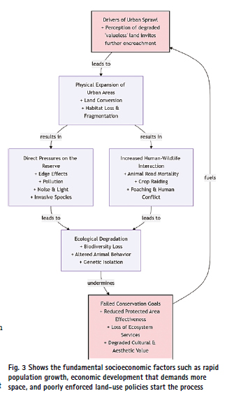
to severe ecological damage, causing a significant decline in biodiversity, along with notable alterations in animal behavior and genetic isolation. Crucially, this model reveals a detrimental feedback loop: the failure to achieve conservation objectives diminishes the ecological, economic, and cultural significance of the reserve, thereby undermining the political and social commitment to its protection. As a result, this perception encourages further encroachment and weakens governance, contributing to sprawl. It is imperative to break this self-perpetuating cycle before conservation areas are irreversibly exhausted, which highlights the systemic nature of the threat and the necessity for integrated planning and proactive policy interventions to break it.
4.1 Challenges and opportunities for conservation efforts
In their study, Appiah-Opoku et al., [5], showed that a key challenge to conservation lies within the weak institutional and regulatory frameworks that govern urban planning in many of the SSA countries. Upon further investigation, the authors found that most of the existing urban planning regulations are outdated and fail to address urban growth pressures experienced or to protect green spaces effectively. In addition, the challenges in the legislative and policy enforcement capacity and the existence of corruption make it difficult to implement sustainable land use practices [44]. Furthermore, the socio-economic factors complicate the efforts to manage urban expansion through increasing the demand for housing spaces and establishment of informal settlements [59].
Lack of funding and resources serve as a major challenge to conservation, especially in the SSA. The protected area management in most SSA countries are underfunded with budgets being below the minimum needed for conservation efforts with a few exceptions in countries such as South Africa, Kenya and Rwanda [8].
The papers reviewed showed that despite the existence of challenges, the opportunities offered far outweigh the difficulties. Remote sensing and GIS technologies provide several opportunities for conservation efforts such as providing and enabling the identification and mapping of critical habitats under threat from urban sprawl (Nizamani et al. 2024). These tools facilitated spatial and temporal monitoring for land cover changes allowing conservation managers and urban planners to detect patterns of habitat loss in near real time [34]. This enhanced technological capability allows for adaptive management by informing where conservation is needed and by tracking the effectiveness of the employed measures over time [4, 8].
Moreover, the integration of remote sensing data with local ecological and socio-economic information helps in the designing of context specific strategies that balance urban development with biodiversity conservation [4]. For instance, satellite imagery can detect deforestation patterns while the ground level data on land use practices can reveal the underlying drivers for the deforestation such as agricultural purposes, resource extraction and/or the establishment of settlements among many. By overlaying these data sets in GIS platforms such as QGIS and ArcGIS, it becomes easy to visualize areas where deforestation had high occurrence rates. This allows informed intervention that addresses forest areas protection. For instance, a study that was conducted in Kuantan district in Malaysia where Landsat and Sentinel imagery were used to classify the LULC over time. The results from the study showed the capability of RS and GIS technologies to track deforestation and encroachment onto forested areas [62]. From the results, recommendations to practice sustainable landscape and town planning management were made in order to reduce the rate at which deforestation is occurring and reduce pressure on the ecologically sensitive areas [62].
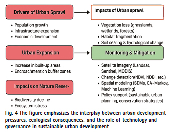
Figure 4 illustrates the relationship between population growth, infrastructure expansion and economic development and how they contribute to urban sprawl. The result is urban expansion, which is characterized by an increase in built-up areas and the encroachment of buffer zones, straining surrounding ecosystems. The transmission of these effects exerts a direct and adverse impact on biodiversity, manifesting in the destruction of essential vegetation types, land fragmentation, and systemic ecosystem stress. To interrupt this causal chain, the proposed framework introduces a synergistic counter strategy. This strategy leverages the diagnostic capabilities of change detection indices and remote sensing for monitoring purposes, the prognostic capabilities of spatial simulation models for planning, and emphasizes the necessity of policy interventions to initiate concrete and sustainable urban development measures.
4.2 Harmonizing development with environmental protection
Balancing urban development with biodiversity conservation imperatives has become a critical policy within the SSA but remains a challenge. It requires the integration of ecological stewardship with inclusive growth strategies. Multiple approaches have emerged in order to address this balance, with integrated land use planning being a fundamental strategy. This strategy places emphasis on having green buffers and wildlife corridors that maintain ecosystem connectivity while accommodating controlled urban development [8]. These green buffers act as a vital transitional zone that reduces the edge effects of urbanization on natural habitats, providing safe passages and the continuity of habitats for biodiversity. The integration of wildlife corridors is crucial as they are essential in preventing and reducing habitat degradation [8]. They do this by linking isolated patches of natural habitats, facilitating gene flow, reducing species migration and resilience against challenges faced by the environment.
In addition to the physical planning measures, many countries have adopted nature-based solutions within the urban environments. The integration of green spaces such as parks, community gardens and vertical gardens, is heavily promoted as they serve crucial ecological functions. The ecological benefits include support for pollinators, improve air and water quality, reduce urban heat island effects and provide microhabitats for biodiversity found within the developed areas. With green spaces integration it is easy to even get the community involved in environmental protection as they also enhance aesthetic and recreational appeal and opportunities [12].
According to Cassano (2020), cross sector collaboration is vital in balancing the complex interplay between increased urban development and biodiversity conservation. This means governments, urban developers, conservation organizations, academia and the public must work together to align this economic development with ecological preservations. Involving these diverse stakeholders ensures that environmental conservation efforts are socially inclusive and in other cases, culturally appropriate [12]. Aligning the national development agendas with global frameworks such as the United Nations Sustainable Development goals and the African Union’s agenda 2063 should be promoted as they can guide the countries toward a more balanced development [26]. Ultimately, seeking and working towards a development that is both socially and environmentally equitable is important if we want to secure the long-term viability of the environment and for preservation of biodiversity.
4.3 Policy implications and recommendations for managing urban sprawl in nature reserves
4.3.1 Integration of nature reserves into urban planning frameworks
A major policy implication is the need to harmonize urban planning with biodiversity conservation. In many cases, nature reserves or natural green spaces are not sufficiently considered during the spatial planning process resulting in a degradation of natural land-scapes and weak buffer zones [14]. The relevant and competent authority must ensure that nature reserves are legally designated within urban development plans at both local and national levels through ensuring that the spatial development frameworks (SDF’s) and Integrated Development Plans (IDPs) clearly outline ecological boundaries and provide legal protection for these nature reserves [6]. The Integration of comprehensive land use regulations is a very crucial aspect as well, policies such as zoning restrictions, urban growth boundaries and conservation easements serve to protect these sensitive natural areas [10].
4.3.2 Strengthening institutional mandates and capacity
Most nature reserves have institutions that are empowered through legislative frame-works. The institutions have enforcement authority that enables them to make decisions on any unauthorized developments that may take place on the reserve. They are also responsible for managing and monitoring them [5]. Studies highlight that these institutions are usually underfunded and sometimes lack technical capacity to enforce the existing land use and conservation regulations. This poses challenges on monitoring urban encroachment within these natural landscapes. To address such an issue, the governments should prioritize the allocation of resources and support to conservation agencies. This includes but is not limited to the investments in GIS land-based monitoring tools, legal expertise and human resources that will be essential in enforcing compliance with conservation priorities [10].
According to Appiah-Opuku et al. 2023, the impacts on the environment due to urban sprawl call for a re-evaluation of the existing development policies. What this means is there needs to be a strengthening in the regulatory frameworks that govern land expansion and conversion of land especially in areas that border nature reserves/protected areas such as strengthening zoning laws, enforcement mechanisms and mandates so that the conservation priorities for nature reserves are not neglected due to short term developmental interests.
4.3.3 Public awareness and community participation
Granxabe et al., [8] showed that awareness among local populations about the ecological value of nature reserves is important. Residents, particularly those who are living in informal settlements may unknowingly be encroaching into these protected areas in search of land. This study continues to show that residents living near nature reserves have mixed attitudes towards them, mostly due to their socio-economic statuses with some recognizing their ecological importance and value, and some not [24]. While some of the residents’ value nature reserves as important sanctuaries for protecting biological diversity and maintaining ecosystem services like clean water among many, factors such as unemployment and poverty lead other residents to view the conservation efforts as challenging to their livelihood especially when they restrict their access to the protected area [24, 42]. In some cases, however, the importance of nature reserves is not recognized due to residents being unaware of their ecological importance, their protected status and their conservation objectives [46]. This is mostly due to inadequate outreach efforts by authorities and a significant lack and challenges in information accessibility.
5 Conclusion
While the physical manifestation of urban sprawl is the most visible aspect, it is critical to view it as a multidimensional phenomenon. Its causes and consequences go well beyond simple land cover change. The socio-economic dimension is evident in SSA, where sprawl is inextricably linked to urban poverty and inequality, manifesting as unplanned informal settlements lacking basic services and secure land tenure [28]. This, in turn, exacerbates the environmental dimension, as these areas frequently suffer from insufficient waste management, resulting in soil and water pollution [24], and are frequently located in ecologically sensitive areas, posing direct threats to biodiversity.
Furthermore, these dynamics are supported by a governance and infrastructural dimension that includes weak regulatory frameworks, ineffective planning policies, and the enormous financial burden of providing services to dispersed, low-density communities. The interplay of these dimensions physical, socioeconomic, environmental, and governance defines the unique challenge of urban sprawl in SSA and necessitates the use of sophisticated monitoring tools.
Within the SSA, there are emerging studies on urban sprawl demonstrating rapid urbanization within the countries. Compared to other global regions that are more developed such as China and Europe, research within the SSA is comparatively limited. Application of RS and GIS in urban sprawl monitoring has been essential in providing opportunities for conservation of natural spaces due to their ability to assess changes in LULC patterns and environmental impacts. Majority of urban sprawl studies identified during this review depended on using Landsat imagery with medium resolution for landcover detection. Landsat imagery remains invaluable due to its cost effectiveness and availability. Most importantly the usage of Landsat imagery allows for a long-term change detection due to its long-term historical archive [41]. The combination of satellite imagery and socio-environmental data provides valuable insight into habitat and biodiversity fragmentation. Using these technologies also encourages scenario building that is essential in future prediction of urban sprawl impacts on natural ecosystems. This capability allows for interventions and mitigation of impacts before they occur. These processes result in urban expansion, characterized by an increase in built-up areas and the encroachment of buffer zones, thereby exerting significant pressure on adjacent natural ecosystems. Consequently, there are direct impacts on natural reserves and biodiversity, including vegetation loss (such as grasslands, wetlands, and forests), habitat fragmentation, soil sailing, hydrological alterations, biodiversity decline, and ecosystem stress. To address these challenges, the framework underscores the importance of monitoring and mitigation measures. Remote sensing technologies (e.g., Landsat, Sentinel, MODIS) and change detection indices (e.g., NDVI, NDBI) provide essential tools for tracking land-use change. Furthermore, spatial modeling techniques, such as Species Distribution Models (SDMs), Cellular Automata-Markov models, and machine learning approaches, can aid in projecting future scenarios and guiding planning. Finally, policy support through sustainable urban planning and conservation strategies constitutes a critical component in mitigating the adverse ecological impacts of urban sprawl.
A common theme noticed during this review was that most of research that involved the application of GIS and RS in urban sprawl monitoring seemed to be concentrated within a few countries in the SSA that have the largest urban areas such as South Africa, Kenya, Ghana and Nigeria. There is still a lack of research in most of the small central African countries that needs to be investigated and addressed to close data gaps and challenges.
Author contributions
Mosa Koloko: Conceptualization; methodology; systematic literature search; data extraction; formal analysis; original draft preparation. Thabang Maphanga: Methodology refinement; validation; data interpretation; writing – review and editing; supervision. Bennett Siyabonga Madonsela: Data interpretation; writing – review and editing; visualization; critical revisions. Xolisiwe Sinalo Grangxabe: Writing – review and editing; policy and management synthesis; critical revisions. All authors reviewed and approved the final version of the manuscript and agree to be accountable for all aspects of the work.
Funding
This research did not receive funding.
Data availability
No datasets were generated or analysed during the current study.
Declarations
Ethics approval and consent to participate: Not applicable.
Consent for publication: Not applicable.
Competing interests: Benett Siyabonga Madonsela declares they are an Editorial Board Member of Discover Environment and confirms that they were not involved in the handling or decision-making of their own submission.
Received: 1 December 2025
Accepted: 1 March 2026
Published Online 10 April 2026
References
1. Abrahams C, Everatt D. City profile: Johannesburg, South Africa. Environ Urban Asia. 2019;10(2):255–70.
2. Aduko J, Aminu Yakubu M, Anokye K. Assessing the environmental impacts of urban sprawl on vegetation cover and ecosystem integrity in Wa Municipality, Ghana. World Dev Sustain. 2025. https://doi.org/10.1016/j.wds.2025.100225.
3. Al Tarawneh WM. Urban sprawl on agricultural land (literature survey of causes, effects, relationship with land use planning and environment): a case study from Jordan (Shihan Municipality Areas). J Environ Earth Sci. 2014;4(20):97–124.
4. Ale S, Adjonou K, Segla KN, Komi K, Zoungrana JBB, Aholou C, et al. Urban forestry in Sub-Saharan Africa: challenges, contributions, and future directions for combating climate change and restoring forest landscapes. Sustainability Basel. 2025;17(1):24.
5. Appiah-Opoku S, Manu KK, Asibey MO, Amponsah O. Tragedy of urban green spaces depletion in selected sub-Sahara African major cities. J Afr Stud Dev. 2023;15(3):46–61.
6. Austin G. Green infrastructure for landscape planning: integrating human and natural systems. Routledge; 2014.
7. Ayeni AO, Aborisade AG, Onuminya TO, Soneye ASO, Ogundipe OT. Urban development in Africa and impact on biodiversity. Curr Landsc Ecol Rep. 2023;8(2):73–89.
8. Aziz HA, Rasidi MH. The role of green corridors for wildlife conservation in urban landscape: A literature review. In IOP Conference Series: Earth and Environmental Science (Vol. 18, No. 1, p. 012093). IOP Publishing. 2014. Available at: https://doi.org/10.1088/1755-1315/18/1/012093/meta.
9. Bassett R, Young PJ, Blair GS, Samreen F, Simm W. The megacity Lagos and three decades of urban heat island growth. J Appl Meteorol Climatol. 2020;59(12):2041–55.
10. Benedict MA, McMahon ET. Green infrastructure: linking landscapes and communities. Island press. 2012.
11. Bocquier P. Analyzing urbanization in sub-Saharan Africa. In: New forms of urbanization. Routledge; 2017. p. 133–50.
12. Casasanto L. How cross-sector partnerships are scaled up for urban ecological impacts: Strategising biodiversity and tackling grand challenges to create synergies for the planet, people and profit (Doctoral dissertation, The University of Waikato). 2020. Available at: https://researchcommons.waikato.ac.nz/entities/publication/7aa040d7-ce48-405c-90d5-e3c3a3d1de99.
13. Dadi D, Azadi H, Senbeta F, Abebe K, Taheri F, Stellmacher T. Urban sprawl and its impacts on land use change in Central Ethiopia. Urban For Urban Green. 2016;16:132–41.
14. Dhote M, Sen J. Interface between instruments of development planning and biodiversity planning and conservation. In: Biodiversity and livelihood: lessons from community research in India. Bentham Science Publishers; 2020. p. 144–76.
15. Dyachia ZS, Permana AS, Ho CS, Baba AN, Agboola OP. Implications of present land use plans on urban growth and environmental sustainability in a Sub Saharan Africa City. Int J Built Environ Sustain. 2017;4(2). Available at https://ijbes.utm.my/index.php/ijbes/article/view/181.
16. Ewing R. Is Los Angeles-style sprawl desirable? J Am Plan Assoc. 1997;63(1):107–26.
17. Festus IA, Omoboye IF, Andrew OB. Urban sprawl: environmental consequence of rapid urban expansion. Malaysian J Soc Sci Humanities (MJSSH). 2020;5(6):110–8.
18. Frimpong BF, Molkenthin F. Tracking urban expansion using random forests for the classification of Landsat imagery (1986–2015) and predicting urban/built-up areas for 2025: a study of the Kumasi Metropolis, Ghana. Land Basel. 2021;10(1):44.
19. Fuladlu K. Urban sprawl negative impact: Enkomi return phase. J Contemp Urban Aff. 2019;3(1):44–51.
20. Fuladlu K. Urban sprawl measurement with use of VMT pattern: A longitudinal method in case of Famagusta. Int J Adv Appl Sci. 2020;7(5):12–9.
21. Fuladlu K, Riza M, Ilkan M. Monitoring urban sprawl using time-series data: Famagusta region of Northern Cyprus. SAGE Open. 2021. https://doi.org/10.1177/21582440211007465.
22. Gombe KE, Asanuma I, Park JG. Quantification of annual urban growth of Dar es Salaam Tanzania from Landsat time series data. Adv Remote Sens. 2017;6(3):175–91.
23. Gorelick N, Hancher M, Dixon M, Ilyushchenko S, Thau D, Moore R. Google Earth Engine: Planetary-scale geospatial analysis for everyone. Remote Sens Environ. 2017;202:18–27.
24. Grangxabe XS, Maphanga T, Chidi BS. Urban nature reserves waste challenges from neighboring informal settlements: Western Cape, South Africa. Nat Environ Pollut Technol. 2024. https://doi.org/10.46488/NEPT.2024.v23i03.018.
25. Grangxabe XS, Maphanga T, Madonsela BS. Public participation on waste management between nature reserves and surrounding informal settlement: a review. J Air Waste Manag Assoc. 2023;73(8):589–99.
26. Güneralp B, Lwasa S, Masundire H, Parnell S, Seto KC. Urbanization in Africa: challenges and opportunities for conservation. Environ Res Lett. 2017;13(1):015002.
27. Habibi SH, Asadi M. Causes and consequences of informal settlements formation in urban areas. Case study: informal settlements of Zahedan City. Geogr Environ Plan. 2011;22(3):121–44.
28. Hailu T, Assefa E, Zeleke T. Land use transformation by urban informal settlements and ecosystem impact. Environ Syst Res. 2024;13:32. https://doi.org/10.1186/s40068-024-00359-2.
29. Hansen MC, Potapov PV, Moore R, Hancher M, Turubanova SA, Tyukavina A, et al. High-resolution global maps of 21st-century forest cover change. Science. 2013;342(6160):850–3.
30. Horn A, Van Eeden A. Measuring sprawl in the Western Cape Province, South Africa: an urban sprawl index for comparative purposes. Reg Sci Policy Pract. 2018;10(1):15–24. https://doi.org/10.1111/rsp3.12109.
31. Ibimilua AF, Ibimilua FO, Ogundare BA. Urban Sprawl: Environmental Consequence of Rapid Urban Expansion, Malaysian. J Soc Sci Humanities (MJSSH). 2020;5(6):110–8. https://doi.org/10.47405/mjssh.v5i6.411.
32. Jat MK, Garg PK, Khare D. Monitoring and modelling of urban sprawl using remote sensing and GIS techniques. Int J Appl Earth Observation Geoinform. 2008;10(1):26–43.
33. Johnson E, Klemens M. 2. The impacts of sprawl on biodiversity. In: Johnson E, Klemens M, editors. Nature in fragments: the legacy of sprawl. New York Chichester, West Sussex: Columbia University Press; 2005. p. 18–54. https://doi.org/10.7312/john12778-004.
34. Krishnaveni KS, Anilkumar PP. Managing urban sprawl using remote sensing and GIS. The International Archives of the Photogrammetry, Remote Sensing and Spatial Information Sciences. 2020;42:59–66. Available at: https://isprs-archives.copernicus.org/articles/XLII-3-W11/59/2020/.
35. Lathrop RG, Bognar JA. Applying GIS and landscape ecological principles to evaluate land conservation alternatives. Landsc Urban Planning. 1998;41(1):27–41. https://doi.org/10.1016/S0169-2046(98)00047-4.
36. Magidi J, Ahmed F. Assessing urban sprawl using remote sensing and landscape metrics: a case study of City of Tshwane, South Africa (1984–2015). Egypt J Remote Sens Space Sci. 2019;22(3):335–46. https://doi.org/10.1016/j.ejrs.2018.07.003.
37. Muchelo RO, Bishop TF, Ugbaje SU, Akpa SI. Patterns of Urban Sprawl and Agricultural Land Loss in Sub-Saharan Africa: the cases of the Ugandan Cities of Kampala and Mbarara. Land. 2024;13(7):1056.
38. Mukete B, Sun Y. Assessing the effectiveness of urban nature reserves on biodiversity conservation. Appl Ecol Environ Sci. 2014;2(6):130–4. https://doi.org/10.12691/aees-2-6-1.
39. Oberholster PJ, Botha A-M, Cloete TE. Biological and chemical evaluation of sewage water pollution in the Rietvlei Nature Reserve wetland area, South Africa. Environ Pollut. 2008;156(1):184–92. https://doi.org/10.1016/j.envpol.2007.12.028.
40. Oyewo O, Oyewale OO. Population growth and economic wellbeing in Lagos, Nigeria. Niger J Hortic Sci. 2023;27(2):95–106.
41. Parra L. Remote sensing and GIS in environmental monitoring. Appl Sci. 2022;12(16):8045.
42. Queiros DR. Towards pro-conservation attitudes and behaviour by local communities bordering protected areas in South Africa. PhD. University of South Africa. 2019. Available at: https://core.ac.uk/download/pdf/333875457.pdf [Accessed 11 Apr. 2025].
43. Roy B, Kasemi N. Monitoring land use/cover change and urban sprawl using remote sensing data: a study of Siliguri and Raiganj Urban Agglomerations, India. In: Anthropogeomorphology: A Geospatial Technology Based Approach. Cham: Springer International Publishing; 2022. p. 525–45.
44. Saghir J, Santoro J. Urbanization in Sub-Saharan Africa. In Meeting Challenges by Bridging Stakeholders. Washington, DC, USA: Center for Strategic & International Studies. 2018.
45. Sen G. Effects of urban sprawl due to migration on spatiotemporal land use-land cover change: a case study of Bartın in Türkiye. Sci Rep. 2025;15:815. https://doi.org/10.1038/s41598-025-85353-z.
46. Sena-Vittini M, Gomez-Valenzuela V, Ramirez K. Social perceptions and conservation in protected areas: taking stock of the literature. Land Use Policy. 2023;131:106696. https://doi.org/10.1016/j.landusepol.2023.106696.
47. Sensing ER. What is Remote Sensing?. 2014. Available at: https://books.google.com/books?hl=en&lr=&id=whbHEAAAQBAJ&oi=fnd&pg=PA281&dq=what+is+remote+sensing+&ots=ZOjLom4hW0&sig=sYUDtm_3YRGTWb5ecKyA2s4JRDg.
48. Shao Z, Sumari NS, Portnov A, Ujoh F, Musakwa W, Mandela PJ. Urban sprawl and its impact on sustainable urban development: a combination of remote sensing and social media data. Geo-spat Inf Sci. 2021;24(2):241–55.
49. Shi K, Chen Y, Yu B, Xu T, Li L, Huang C, et al. Urban expansion and agricultural land loss in China: a multiscale perspective. Sustainability. 2016;8(8):790.
50. Simkin RD, Seto KC, McDonald RI, Jetz W. Biodiversity impacts and conservation implications of urban land expansion projected to 2050. Proc Natl Acad Sci U S A. 2022;119(12):e2117297119.
51. Sinha SK. Causes of urban sprawl: a comparative study of developed and developing world cities. Res Rev J. 2018; 03(9). Available at: https://old.rrjournals.com/wp-content/uploads/2018/09/05-09_RRIJM180309002.pdf.
52. UN-Habitat. Johannesburg: City Context Report. Global Future Cities Programme. 2018. Available at: City Context Report_Joburg.pdf.
53. Venter C, Mahendra A, Hidalgo D. From mobility to access for all: Expanding urban transportation choices in the global south. Washington, DC: World Resources Institute; 2019. p. 1–48.
54. Wei YD, Ewing R. Urban expansion, sprawl and inequality. Landsc Urban Plan. 2018;177:259–65.
55. World bank group (n.d). Demographic trends and urbanization. Available at: World Bank Document.
56. World Population Review. World Population Review. 2025. Available at: https://worldpopulationreview.com/about.
57. Wulder MA, Loveland TR, Roy DP, Crawford CJ, Masek JG, Woodcock CE, et al. Current status of Landsat program, science, and applications. Remote Sens Environ. 2019;225:127–47.
58. Xu G, Dong T, Cobbinah PB, Jiao L, Sumari NS, Chai B, et al. Urban expansion and form changes across African cities with a global outlook: spatiotemporal analysis of urban land densities. J Clean Prod. 2019;224:802–10.
59. Yiran GA. Urban sprawl and sustainability: a comparative analysis of Accra and Kumasi urban regions. Ghana Soc Sci J. 2020;17(1):20–20.
60. Yussif K, Dompreh EB, Gasparatos A. Sustainability of urban expansion in Africa: A systematic literature review using the Drivers–Pressures–State–Impact–Responses (DPSIR) framework. Sustain Sci. 2023;18(3):1459–79.
61. Zhang L, Shu X, Zhang L. Urban sprawl and its multidimensional and multiscale measurement. Land. 2023;12(3):630.
62. Zulkifli MA, Gisen A, Isabella J, Misbari S, Samat SR, Yu Q. Machine learning and remote sensing applications for assessing land use and land cover changes for undermonitored basin. Pertanika J Sci Technol. 2024. https://doi.org/10.47836/pjst.32.6.15.
Publisher’s Note
Springer Nature remains neutral with regard to jurisdictional claims in published maps and institutional affiliations.
© The Author(s) 2026. Open Access This article is licensed under a Creative Commons Attribution-NonCommercial-NoDerivatives 4.0 International License, which permits any non-commercial use, sharing, distribution and reproduction in any medium or format, as long as you give appropriate credit to the original author(s) and the source, provide a link to the Creative Commons licence, and indicate if you modified the licensed material. You do not have permission under this licence to share adapted material derived from this article or parts of it. The images or other third party material in this article are included in the article’s Creative Commons licence, unless indicated otherwise in a credit line to the material. If material is not included in the article’s Creative Commons licence and your intended use is not permitted by statutory regulation or exceeds the permitted use, you will need to obtain permission directly from the copyright holder. To view a copy of this licence, visit http://creativecommons.org/licenses/by-nc-nd/4.0/.
https://doi.org/10.1007/s44274-026-00628-0
The paper is originally published in Discover Environment (2026) 4:167 and republished here with author’s permission.





Leave your response!