Articles in the GIS Category
The European Commission, Directorate- General Environment, is inviting comments on the implementation of the Infrastructure for Spatial Information in the European Community (INSPIRE) Directive (2007/2/EC).

Spatio-temporal rainfall changes at tropics had raised concern among scientists. However, comprehensive studies at catchment scale of Southeast Asia where the combined regional and local factor is a tough task to be carried out due to the inherent limitations of rainfall data sources especially in the remote

Most applied methods to determine the tourism demand depend on the availability of demographic data, social and economic characteristics of tourists, tourism customs, the quality of tourist activities and facilities, and other foundations such as the capacity of the tourist destination, and its accessibility…

Burgeoning energy needs in the 21st century are driving demands for more petroleum products. These needs were hitherto met by using pipes to transport required energy products over long distances within countries and across borders, from their sources to respective destinations (Chai et al, 2006; Yildirim et al, 2007; Dubey, 2009). However, increase in global…

Slums in Egypt – as in many developing countries – are considered as one of the most important problems in Egypt. There are about 1,100 slum areas hosting about 16 million inhabitants. Slums in Egypt vary considerably in their characteristics which make prioritization and intervention policy a debatable issue.

The Kingdom of Saudi Arabia (KSA) Ministry of Interior (MOI) has initiated a major development program for its Border Guard (BG) to develop the BG’s organization into a 21st century security force capable of delivering comprehensive border protection [KSA MOI 2007]. Such a sustainable approach requires a comprehensive modernization and integration of command, control, communications, computers, intelligence, surveillance and reconnaissance (C4ISR), supporting…

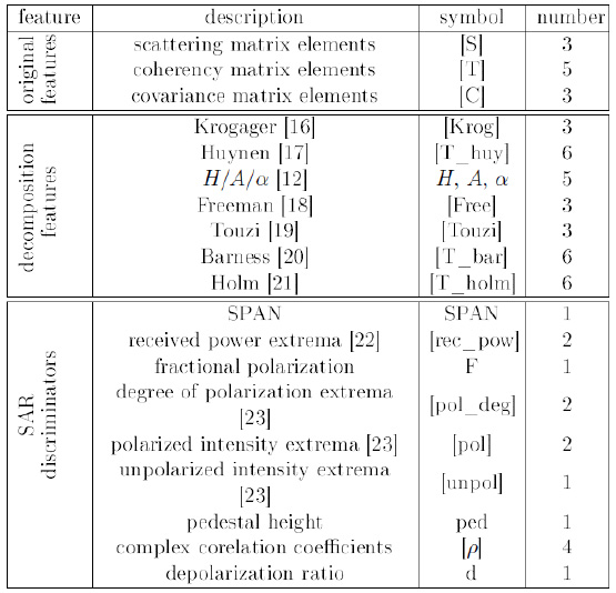
Two Radarsat-2 images acquired in fine quad-polarized mode were chosen for this study. The images were collected in leaf-on and leaf-off seasons. The experimental results demonstrated that the neighboring information provides valuable information for the classification of Polarimetric SAR data. The classification results showed that the proposed methodimproves classification accuracy significantly over the baseline methods.

Landslide occurrence is one of the natural disasters which causes great damages annually all over the world and that is the reason, prediction and monitoring of landslides is of great concern. Landslide susceptibility determination relies largely on information which is provided by the landslide inventory maps. Therefore, precise land displacement determination can be regarded as one of the preliminary steps towards a more reliable landslide prediction.


 (5.00 out of 5)