|
|
|
|
|
|
 |
|
|
Topcon and Sokkia merge
The merger between Topcon Corporation and Sokkia Co, Ltd, both with corporate headquarters in Japan, was confirmed on 5 February. Both companies are the two largest Japanese manufacturers of survey equipment. Sokkia will become a wholly owned subsidiary of
Topcon Corporation. |
MobileMapper 6 and ProMark 500 by Magellan
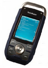 Magellan has recently introduced the rugged, waterproof, handheld GPS/GIS receiver, fulfilling the requirements for low-cost, professional GIS field data collection. It is expected to particularly appeal to forestry and other natural resource organizations, oil and gas, agriculture, utilities, and businesses large and small that can collect GIS data with 2-5 meter accuracy in real-time with SBAS corrections. ProMark 500, a dual-frequency GNSS receiver from Magellan processes GPS, GLONASS and SBAS signals to offer land surveyors fast, real-time centimeter-level accurate surveying. www.pro.magellangps.com. Magellan has recently introduced the rugged, waterproof, handheld GPS/GIS receiver, fulfilling the requirements for low-cost, professional GIS field data collection. It is expected to particularly appeal to forestry and other natural resource organizations, oil and gas, agriculture, utilities, and businesses large and small that can collect GIS data with 2-5 meter accuracy in real-time with SBAS corrections. ProMark 500, a dual-frequency GNSS receiver from Magellan processes GPS, GLONASS and SBAS signals to offer land surveyors fast, real-time centimeter-level accurate surveying. www.pro.magellangps.com.
|
|
|
|
|
|
|
|
Guidance system for Army program
Integrated Guidance Systems LLC (IGS LLC), a Honeywell International and Rockwell Collins joint venture, has been awarded a subcontract to provide the deeply integrated navigator for the U.S. Army Non-Line of Sight- Launch System (NLOS-LS) program It calls for developing guidance systems for the NLOS-LS Precision Attack Missile (PAM) and Container Launch Unit (CLU). www.rockwellcollins.com |
|
|
Sprinter 50 from Leica Geosystem
Leica Sprinter 50 is a multifunctional levelling tool which is compact and lightweight, yet easy to use, and error free, electronic level. The user can just aim, focus, and measure by pressing one button displaying the data instantly. Misreadings are eliminated, and error reducing functions, such as the tilt sensor, prevent the system from
measuring if the user operates outside the compensator range. |
|
|
|
|
|
ERDAS IMAGINE 9.2 by Leica Geospatial Imaging
Leica has released ERDAS IMAGINE® 9.2, indu+stry’s leading collection of software tools designed to manipulate, process and understand imagery.www.leica-geosystems.com |
|
|
|
|
|
Utilities solutions to small providers and electric Co-ops
Intergraph Corp. shall be offering the benefits of its utility outage management, workforce management and GIS technology to rural and small utilities and electric cooperatives through packaged solutions for the smaller utility market. It is now able to provide utilities of all sizes – from the smallest to the largest-with end-to-end solutions for the design and operations of the utility distribution network. www.intergraph.com. |
|
|
|
|
|
PCI Geomatics India launched
PCI Geomatics has launched of a new international office in India. It will be led by Dr. Ashok Kaushal, Director and Country Manager, and, under special license, will offer PCI Geomatics technology, services and solutions for both the private and government sectors. www.pcigeomatics.com |
|
|
Infotech awarded new Catalist framework agreement
Infotech Enterprises has been awarded by OGCbuying solutions, the Government’s leading procurement services organisation for the UK to provide a broad remit of Geospatial Information Services and Solutions for public sector customers under the new Catalist GISS framework agreement. www.infotech-enterprises.com |
|
|
Hemisphere GPS introduces outback S3
Hemisphere GPS has recently introduced Outback S3™ representing the next generation in Outback Guidance® products by Hemisphere GPS. It combines the most popular features of both the market proven Outback S2™ and the Outback 360™ with the latest developments in Crescent® GPS receiver technology. |
|
|
NXP launches first Gps chipset following GloNav acquisition
After the acquisition of GPS technology provider GloNav Inc, NXP Semiconductors has announced its first single-chip, Assisted-GPS solution. It is designed for use in both mobile phones and standalone Personal Navigation Devices. NXP claims “the industry’s smallest, lowest power, lowest system cost GPS solution”. www.gpsbusinessnews.com |
|
|
Pictometry and AAMHatch sign technology agreement
Pictometry International Corp has signed an agreement with AAMHatch of Australia to expand the coverage area for Pictometry’s patented image capture process into 12 countries. Under the agreement, has expanded its prior exclusive rights to utilize Pictometry’s image capture and processing technology and market image libraries and software in South Africa, Singapore, Malaysia, Thailand, Indonesia, Fiji, Papua New Guinea, East Timor, Brunei, Vietnam, Laos, and Cambodia. www.pictometry.com. |
|
|
Chronos releases TrineX
Chronos Technology, the GNSS and RF Microwave components specialist has released TrineX CW27, a self-contained GPS receiver module based on the Nemerix NX3 A-GPS single chip receiver. It utilises a new base band processor and RF front end, the TrineX shall deliverssuperior GPS performance in a small surface mount package that minimizes power consumption, maximizing battery life. www.chronos.co.uk |
|
|
Trimble offers free geocaching application for Nokia phones
Trimble has announced the availability of a free, ad-supported version of its Geocache Navigator(TM) application for select Series 60 Nokia devices with integrated GPS capabilities. It is an application that brings geocaching capabilities to the mobile phone and provides real-time access to Groundspeak’s geocaching. com, the largest geocache database in the world. Using their GPS-enabled phone, geocachers can seek the caches using a uniquely constructed, radar-like interface that guides them toward their destination. http://www.geocachenavigator.com/video |
|
|
Autodesk Enhances Geospatial Software Solutions
Autodesk, Inc. has announced the latest enhancements in several products; AutoCAD Map 3D 2009, Autodesk MapGuide Enterprise 2009 and AutoCAD Raster Design 2009 software applications build on the solutions’ fundamental properties of open data access and interoperability with other design, GIS and IT systems. |
|
|
Trimble offers free geocaching application for Nokia phones
Trimble has announced the availability of a free, ad-supported version of its Geocache Navigator(TM) application for select Series 60 Nokia devices with integrated GPS capabilities. It is an application that brings geocaching capabilities to the mobile phone and provides real-time access to Groundspeak’s geocaching. com, the largest geocache database in the world. Using their GPS-enabled phone, geocachers can seek the caches using a uniquely constructed, radar-like interface that guides them toward their destination. http://www.geocachenavigator.com/video |
|
|
Optech ILRIS-3D now compatible with Maptek I-site™ studio
Toronto, Canada – Optech has announced that Maptek™ has enabled direct file import functionality of ILRIS-3D open format IXF point cloud data into their I-Site Studio product. ILRIS-3D is a fully portable, laserbased ranging and imaging system for the commercial survey, engineering, mining and industrial markets. |
|
|
Contex awarded BERTL 4-Stars
 Contex has received BERTL’s “Highly Recommended” rating for the CRYSTALG600, CHROMA G600, CHAMELEON G600, and the CHROMA G600 wide format scanners. The rating indicates that the product has been tested and certified as providing exceptional performance and features that offer a lasting return on their investment. Contex has received BERTL’s “Highly Recommended” rating for the CRYSTALG600, CHROMA G600, CHAMELEON G600, and the CHROMA G600 wide format scanners. The rating indicates that the product has been tested and certified as providing exceptional performance and features that offer a lasting return on their investment.
|
|
|
Sydney and Melbourne city councils lead the way
Sydney and Melbourne cities of Australia, have embraced Pictometry, Intelligent Images technology. AAMHatch have been commissioned to provide new “true” orthophotography and updated 3D models for the cities. These cities have also purchased Pictometry oblique aerial imagery which has been recently acquired. |
|
|
Honeywell sees acquisitions in 2008, says CEO
Honeywell International Inc will likely make a few acquisitions in 2008, after pulling back from that strategy a year earlier due to high prices, according to CEO of the company. Honeywell International Inc expects to see its strongest revenue growth this year in India, China and the Middle East, but takes a more conservative view on the United States and Europe, the diversified U.S. manufacturer’s top executive told Reuters on Tuesday. |
|
|
Class action launched against SiRF
Coughlin Stoia Geller Rudman & Robbins LLP, a law firm based in San Diego, has announced that a class action has been commenced in the US District Court for the Northern District of California on behalf of purchasers of SiRF stocks during the period between October 30, 2007 and February 4, 2008. The complaint charges SiRF, its CEO, CFO, Chairman and vice president of marketing with violations of the Securities Exchange Act of 1934. |
|
|
Navteq expands coverage in APAC
NAVTEQ has released a 100% coverage map for New Zealand and Thailand. Detailed coverage, NAVTEQ’s most highly attributed and verified standard is available to 50% of New Zealand’s population in Auckland, Wellington, and Christchurch. The New Zealand map contains a full set of features including points of interest (POI) across approximately 74 categories. Thailand also has a full set of features with 52 categories. |
|
|
Javad GNSS announces new products and pricing
Triumph Chip
Is a 17×17 millimeter power-efficient 352-TFBGA chip. It can track GPS, GLONASS, Galileo, QZSS, WAAS, EGNOS, and Compass/Beidou signals.
Triumph-4X
To improve the reliability of RTK, some users employ data from more than one base. Along with introducing TRIUMPH-4X, Cluster RTK, or 4×4 RTK has also been introduced, where sixteen baselines are processed in every single RTK measurement.
Victor
Victor is pre-loaded with Tracy field software, which automatically connects to TRIUMPH-1 or TRIUMPH- 4X via its internal Bluetooth and guides through field operations.
Tracy
A comprehensive field software for Windows Mobile OS to control receivers, automate GNSS post processing surveying tasks etc.
Justin
It is a GNSS data processing software integrated with elaborate spectrum of GIS features. It uses most rigorous and sophisticated techniques of classical surveying and geodetic formulations for baseline and trajectory calculations as well as network adjustments. |
|
|
|


 (No Ratings Yet)


