| Mycoordinates | |
Managing land information
|
||||
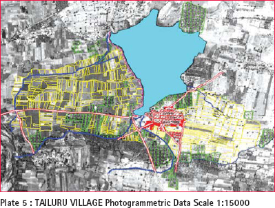
Technology availableDifferent technology available and limitations are discussed in brief below. Ground survey cannot be avoided to build a foolproof record. Depending on the constraints and ground conditions, particular technology can be used. Electronic Total Station Survey Establishing control by traverse and later distance measuring is done using the total stations. This replaces the conventional theodolite and chain measurements or plane table traverse for establishing control. Detail survey is done by digital recording of data instead of FMBs of conventional system. The data can be downloaded, processed and records created. This process is time consuming. Global Positioning System and Total Station GPS is used for establishing control points required for detail survey in an area. This technique is replacement for the theodolite and traversing method, reducing the efforts and time required for establishing stations and observation. However, clear sky view of about 15° over the instrument is essential for tracking of the navigation satellites. Diffi cult to use in jungle/ tree covered areas. Total station is used for further traversing and detail survey electronically, and process in a computer medium. However in this method, we get accurate records after the entire process is completed. Staged upgradation of records using available records is not possible. This is a time consuming process. Photogrammetric survey combined with GPS, Total Station and ground checking Aerial photo gives a pictorial ground truth and is a proof of ground at the time of photography for times to come. Digital Aerial photographs on 1:25,000 scale are suffi cient to prepare a base map on 1:5,000 scale. However, contiguous area of about 5000 sq km will be economical. For rural area this should be suffi cient. In urban areas where land value is of signifi cance, we require measurement accuracy upto 5- 10cm in a plot of 6metres x 9 metres size. In such areas 1:1,000 scale survey will be required and aerial photo on 1:5,000 will be essential. GPS is used to establish minimum ground control required for photogrammetric survey. A base map will be generated on 1:5,000 scale for rural areas and 1:1,000 scale for cities which can be taken to the ground for ground checking and picking up attribute information. The process can be done in two ways: * Generation of line maps from aerial photo: Using digital photogrammetric technique, line maps can be created which can be taken to ground for incorporating cadastral information and other topographical details. This can be brought back to offi ce and incorporated in the data base. Use of PC Tablet/ Palm top for detail survey and data capture in field The digital line maps prepared in photogrammetry can be stored in PC Tablet/ Palm top and taken to ground to incorporate attribute information, down load to computer and process to get information desired. Certain amount of post processing of data will be required. Airborne Laser Terrain Mapping This technology is very costly but can be used in forest areas to get accurate height. Certain amount of post processing is required. Suggested procedureThe task of creating a LIMS cannot be achieved at one go. It is proposed to achieve the goal in an incremental manner with the following objective:- * Establish National Connectivity and use the work of scanning and computerization done already to superimpose and build fi rst level LIS using line map prepared using geo referenced Aerial Photographs (Figure -5) |
||||


 (No Ratings Yet)


