| Imaging | |
IMAGING
Georeferenced Mapping Solution for UAV by Applanix
Applanix Corp and American Aerospace Advisors Inc (AAAI) have announced an OEM supply agreement that will incorporate Applanix’ industry-leading direct georeferencing technology into AAAI’s unmanned aerial platforms. The collaboration creates the industry’s first commercially available professional grade mapping UAV solution for civilian applications such as pipeline monitoring, power line surveys and emergency response mapping. The availability of the solution follows a series of successful test flights of AAAI’s RS-16 Unmanned Aircraft System™ equipped with Applanix’ DMS-UAV aerial photogrammetry payload with commercially available inertial technology. www.american-aerospace.net
First ‘Satellite Remote Sensing Laboratory’ in Sindh inaugurated
First “Satellite Remote Sensing Laboratory” of Pakistan has been established at Crop Reporting Services Centre, Directorate General Agriculture Extension, Agriculture, Supply and Prices Department, Government of Sindh, Hyderabad. Established with the collaboration of Pakistan Space and Upper Atmosphere Research Commission (SUPARCO) and Food and Agriculture Organisation, the purpose of this lab shall be crop monitoring, forecasting and estimation around the year through satellite remote sensing technology. www.brecorder.com
Unmanned drone delivers pizza
In Mumbai, India, a city-based pizza outlet used an unmanned drone to execute a delivery by taking the aerial route recently. “All of us had read about (global e-commerce giant) Amazon’s plans of using drones. We successfully carried out a test-delivery by sending a pizza to a customer located 1.5 km away from our outlet on May 11,” Francesco’s Pizzeria chief executive Mikhel Rajani told.
He stressed that this was only a test-flight but its results confirm that it can be used routinely in a few years. http://tech.firstpost.com
Taiwanese remote sensing scientist defects to China
Taiwanese Chen Kun-shan, a leading expert on remote sensing technology, has secretly defected to China, the Ministry of Education confirmed. The university learned through Chinese media reports in March that Chen had been hired to work at China’s State Key Laboratory of Remote Sensing Science under Beijing’s high-profile “Thousands Talents Program,” which seeks to attract overseas scientists. http://focustaiwan.tw/news/
Sentinel-1 aids Balkan flood relief Although not yet operational, the new Sentinel-1A satellite has provided radar data for mapping the floods in Bosnia and Herzegovina. Heavy rainfall leading to widespread flooding and landslides has hit large parts of the Balkans, killing dozens of people and leaving hundreds of thousands displaced. Jan Kucera of the Europan Commission’s Joint Research Centre is supervising the technical aspect of the Copernicus Emergency Management Service (EMS). While mapping the flooding in northeastern Bosnia and Herzegovina, ESA delivered a radar scan from Sentinel-1A: www.esa.int/
Satellite data used to determine missing MH 370 released
The Malaysian government has released 45 pages of raw satellite data it used to determine that the missing jetliner crashed into the southern Indian Ocean, responding to demands for greater transparency by relatives of some of the 239 people on board. But at least one independent expert said his initial impression was that the communication logs didn’t include key assumptions, algorithms and metadata needed to validate the investigation team’s conclusions that the plane flew south after dropping off radar screens 90 minutes into the flight. www.nydailynews.com
Dubai Municipality, EIAST tie up
As part of the policy to make relationship of cooperation with public sector institutions and organisations in order to provide best services for the society, the Dubai Municipality has signed a MoU with the Emirates Institute of Advanced Science and Technology (EIAST).
The MoU is aimed at cooperation and exchange of information in satellite photography applications for the purpose of scientific studies in the field of remote sensing in different sectors of DM and to recognise EIAST as a partner of DM in relevant fields. http://gulftoday.ae/
Japan launches Daichi-2
Japan has launched the second Advanced Land Observation Satellite, Daichi-2 – better known as ALOS-2 on an H-IIA rocket, last month.Daichi-2 (ALOS- 2) is a radar imaging spacecraft which will be operated by the Japan Aerospace Exploration Agency (JAXA). It will be used for land and resource studies, disaster monitoring and environmental research. The ALOS-2 mission follows on from the original ALOS, which was launched in 2006 and operated for five years until mid-May 2011.
KazEOSat-1 launched
The Kazakhstan’s first earth remote sensing satellite KazEOSat-1 was successfully launched from the French Guiana Space Center on April 30. This high-resolution observation satellite was built by French Airbus Defense and Space (Astrium) for the Earth Remote Sensing Satellite System of the government of Kazakhstan. http://en.trend.az/
Cheetah wins 2013 ESA App Challenge
At the 2013 ESA App Camp, Valentijn Venus and his team developed “Cheetah”, an app designed to minimise food wastage along the entire production and transport chain in Africa with the help of Earth observation satellites. The app was then named 2013’s best smartphone application by ESA as part of the innovation competition Copernicus Masters. The team is now in talks with partners in Africa with an eye towards starting field testing. Meanwhile, discussions are also under way regarding the team’s potential acceptance into the start-up programme of one of the ESA Business Incubation Centres. www.esa.app-camp.eu
NASRDA to Build ‘Made in Nigeria’ Satellite By 2018
The National Space Research and Development Agency (NASRDA), Nigeria is to develop and build a Nigerian satellite by 2018, its Director-General, Prof. Seidu Mohammed, has said. He said that the agency was working on the legal framework of the Nigerian space programme with a view to enhance the nation’s Space Science and Technology Administration. http://allafrica.com
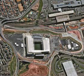
Football stadium from space
Airbus Defence and Space satellites have captured images, taken by the twin Pléiades satellites, of the Arena de Sao Paulo stadium. ftp://ftp.astrium-geo.com/
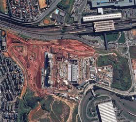
The above images track the construction of the Arena de Sao Paulo, while images shown below depict current satellite images of the stadium.


 (No Ratings Yet)


