| Imaging | |
Imaging
|
||||||||||
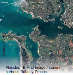
Pleiades 1B, captures its first images using e2v sensors
Pleiades 1B, the Centre National d’Etudes Spatiales (CNES) Earth observation satellite, has captured its first images using e2v high performance imaging sensors. www.e2v.com/
The OGC Wide Area Motion Imagery best practices document
The Open Geospatial Consortium (OGC®) has adopted the OGC Wide Area Motion Imagery Best Practices Document (WAMI BP) as an of􀂿 cial OGC Best Practice. The OGC WAMI Best Practices Document recommends a set of Web service interfaces for the dissemination of Wide Area Motion Imagery (WAMI) products. It describes a performance centric, scalable grammar and schema that enable globally federated dissemination of WAMI products for high performance, high-speed consumption. http:// www.opengeospatial.org/
Vietnam to launch first Earth observation satellite
This will be the third satellite invested in by Vietnam, after Vinasat-1 and Vinasat-2. While the previous two versions mainly serve telecom business and capacity leasing, the third will be launched for scientifi c research. Bui Trong Tuyen, vice president of the Space Technology Institute, informed the Earth observation satellite will be named VNREDSat- 1A, and is scheduled for launch in April or early in the second quarter. SGTChina’s first high-resolution, stereo mapping satellite Ziyuan III meets international standards, ridding the country of its reliance on imports of satellite images. China used to import over 90 percent of its remote-sensing data. The launch of Ziyuan III has enhanced the country’s capability to capture space remote-sensing images, bolstered state security and boosted the geo-information industry. China plans to build a remote-sensing mapping satellite system in 10 to 15 years. Three followup mapping satellites are already in the pipeline. http://www.chinadaily.com.cn/
EagleView and Pictometry announce merger
EagleView® Technologies and Pictometry jointly announced that they have entered into a definitive merger agreement under which EagleView and Pictometry have combined their businesses into a single entity. pictometry.com
Arianespace to launch VNREDSat-1A built by Astrium for Vietnam
Arianespace and Astrium have signed the launch contract for the VNREDSat- 1A Earth observation satellite, on behalf of the Vietnamese Academy of Science and Technology. VNREDSat-1A will be launched during the second quarter of 2013 by the second Vega launcher, VERTA 1, performed by Arianespace at the Guiana Space Center, French Guiana, for the European Space Agency (ESA). The satellite will be carried in the lower position on the Vespa multiple launch structure used for this mission. http://www.arianespace.com/
DARPA reveals plan to use robots to recycle satellites
The Defense Advanced Research Projects Agency (DARPA) has an ambitious plan to service — and even recycle — satellites using robotics. Today, when a satellite fails, it is a total loss. The satellite either burns up in Earth’s atmosphere or lifelessly orbits the planet until a replacement is launched. DARPA’s Phoenix program is a plan to change that cycle by sending robots to scavenge parts from dead satellites and attach them to miniature “satlets” to reuse. The main item of interest for DARPA researchers is how to reuse the antennae of functionless satellites. While most satellites are uniquely designed to serve their particular function, certain pieces of the spacecraft could be recycled – including the antennae and solar arrays. http://www.cbsnews.com/
S Korea launches first satellite into orbit
South Korea has successfully launched a satellite into space from its own soil for the first time, a point of national pride that came weeks after archrival North Korea accomplished a similar feat to the surprise of the world. The South Korean rocket blasted off from a launch pad in the southwestern coastal village of Goheung. Science officials told cheering spectators minutes later that the rocket delivered an observational satellite into orbit. http://www.cbsnews.com/
Japan launches satellites to spy on NoKor
Japan has launched two satellites to strengthen its surveillance capabilities, including keeping a closer eye on North Korea. One of them was a radarequipped unit to complete a system of surveillance satellites that will allow Tokyo to monitor any place in the world at least once a day. The other was a demonstration satellite to collect data for research and development. From an altitude of several hundred kilometres, the radar satellite will be able to detect objects on the ground as small as a square metre, including at night and through cloud cover. http://www.mb.com.ph/
Belarus creating core equipment for Egyptian satellite
Belarus is creating the core equipment for an Egyptian remote sensing satellite, BelTA learned from Mr Oleg Semenov, Chief Engineer of the enterprise Geoinformation Systems of the National Academy of Sciences of Belarus. The Belarusian core equipment will be used by the EgyptSat satellite, which is scheduled for launch in 2014. http:// law.by/main.aspx?guid=105843
Astrium Services partnership with GAF
Astrium Services’ GEO-Information experts have now signed up GAF AG, one of Europe’s leading providers of Earth observation and geo-information solutions, as a channel partner for their satellite data and value-added products in Germany. www.astrium-geo.com


 (No Ratings Yet)


Leave your response!