
| GNSS | |
GNSS (SBAS) Constellation Specific Monthly Analysis Summary: May 2026
|
 |
|
Introduction
This article continues the monthly performance analysis of the GNSS/SBAS constellation. Readers are encouraged to refer to previous issues for foundational discussions and earlier results.
Satellite Based Augmentation Systems (SBAS) enable highintegrity GNSS navigation for all phases of flight, including precisionlike approaches with vertical guidance. In the Asia–Pacific region, several SBAS implementations are progressing at different maturity levels. This article presents a consolidated analysis of four systems—GAGAN (India), MSAS (Japan), KASS (Republic of Korea), and SouthPAN (Australia/New Zealand). The study combines (i) observed Horizontal and Vertical Protection Level behavior from a representative day in April 2026, (ii) officially declared SBAS service capabilities and supported aviation procedures, and (iii) spaceweather conditions on the analysed day. The results provide a coherent view of current SBAS readiness across the Asia–Pacific region, excluding the mature WAAS and EGNOS systems. In the coming month’s issue, further analysis on the topic of clock and orbit corrections of SBAS systems and DFMC will be provided.
1. Observed performance analysis
The GAGAN performance during a random day (day of year 138) May 2026 reveals a relatively stable HPL behavior, with values generally remaining between 10 and 20 meters and only occasional increases toward 25–30 meters. This stability indicates that satellite geometry remains largely sufficient throughout the day. In contrast, VPL exhibits pronounced variability, with fluctuations typically between 15 and 40 meters and a significant spike exceeding 70 meters around mid-day (~35,000 seconds of day).
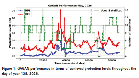
This sharp VPL increase occurs despite a relatively stable number of satellites, indicating that the degradation is primarily driven by ionospheric effects rather than geometry limitations. The timing of the spike corresponds to the period when the equatorial ionosphere is most dynamic due to the Equatorial Ionization Anomaly (EIA), which introduces steep electron density gradients. These gradients are difficult to model accurately within the SBAS framework, leading to increased uncertainty and inflated protection levels. Overall, GAGAN demonstrates a characteristic equatorial response, where performance is generally stable but highly sensitive to localized ionospheric disturbances.
The performance of KASS in May 2026 presents a different behavior compared to GAGAN, reflecting its mid-latitude operational environment. HPL values remain mostly stable in the range of 10 to 20 meters, with occasional peaks reaching approximately 50 meters. VPL values are generally confined between 20 and 35 meters but exhibit a major spike close to 95 meters toward the end of the day (~78,000 seconds).
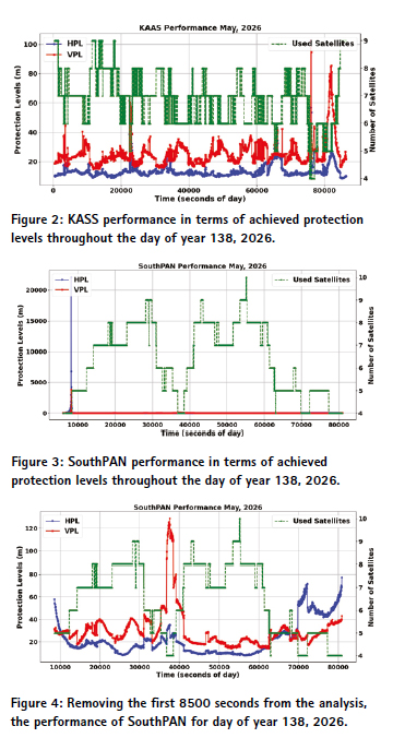
Unlike the GAGAN case, this late-day VPL spike clearly coincides with a reduction in satellite availability to as few as four satellites. This strong correlation indicates that the degradation is primarily geometrydriven rather than ionospheric-driven. With fewer satellites, the positioning geometry weakens significantly, resulting in increased dilution of precision and inflated protection levels. Therefore, KASS performance is characterized by relative robustness under normal conditions but vulnerability to periods of poor satellite geometry, highlighting the importance of constellation availability and redundancy for maintaining integrity.
The SouthPAN system exhibits the most complex and unstable behavior among the three SBAS systems analyzed. One of the most striking observations is an extreme HPL anomaly early in the day in the broader dataset, where the horizontal protection level exceeds 20,000 meters. Such a large value is indicative of a severe failure, likely caused by a loss of valid corrections or a temporary divergence in the integrity algorithm.
In the refined performance plot excluding those impacted epochs, SouthPAN shows a significant VPL spike exceeding 120 meters around mid-day (~38,000 seconds), followed by continued instability throughout the day. Later in the day, HPL values increase to approximately 60–70 meters, coinciding with a reduction in satellite availability. These observations suggest that SouthPAN is affected by both ionospheric disturbances and geometry limitations. The combination of strong ionospheric variability in the region and relatively sparse monitoring infrastructure likely contributes to the observed instability. Compared to the other systems, SouthPAN appears to be less reliable for this day. It was providing better results in last months. There will be a dedicated analysis to understanding and troubleshoot this anomaly.
2. Officially Declared Performance and Supported Procedures
GAGAN is officially certified for RNP 0.1 and APVI with declared APV availability over most of the Indian landmass. MSAS supports enroute and limited terminal operations but does not declare APVI or LPV nationwide. KASS officially supports RNP APCH including LPV with published horizontal and vertical alert limits of 40 m and 50 m respectively. SouthPAN is designed to support APVI, LPV, and LPV200 and has published target VPL values below 35 m over its primary service region.
3. Conclusions
The analysis of May 2026 (DOY: 138) SBAS performance demonstrates that significant degradation can occur even under moderate space weather conditions. GAGAN shows strong sensitivity to equatorial ionospheric dynamics, KASS performance is primarily influenced by satellite geometry constraints, and SouthPAN exhibits both ionospheric and system-level instabilities. Among the three systems, SouthPAN experiences the most severe anomalies, indicating a need for further analysis. This will be provided in next month’s issue.
The results confirm that VPL remains the primary limiting factor for aviation operations, as it is highly sensitive to ionospheric uncertainty. Additionally, satellite availability plays a critical role in maintaining system robustness, emphasizing the importance of multiconstellation integration and redundancy
Data sources and Tools:
https://cddis.nasa.gov (Daily BRDC, RINEX OBS); http://ftp.aiub.unibe. ch/CODE_MGEX/CODE/ (Precise Products); BKG “SSRC00BKG” stream; IERS C04 ERP files
SBAS Mentor, ESA
gLAB GNSS, https://gage. upc.edu/en/learning-materials/ software-tools/glab-tool-suite
serenad-public.cnes. fr (SBAS data)







Leave your response!