| GNSS | |
GNSS Constellation Specific Monthly Analysis Summary: March 2026
The analysis performed in this report is solely his work and own opinion. |
 |
|
Introduction
This article continues the monthly performance analysis of the GNSS constellation. Readers are encouraged to refer to previous issues for foundational discussions and earlier results.
Satellite Based Augmentation Systems (SBAS) enable high-integrity GNSS navigation for all phases of flight, including precision-like approaches with vertical guidance. In the Asia–Pacific region, several SBAS implementations are progressing at different maturity levels. This article presents a consolidated analysis of four systems—GAGAN (India), MSAS (Japan), KASS (Republic of Korea), and SouthPAN (Australia/New Zealand). The study combines (i) observed Horizontal and Vertical Protection Level behavior from a representative day in March 2026, (ii) officially declared SBAS service capabilities and supported aviation procedures, and (iii) spaceweather conditions on the analysed day. The results provide a coherent view of current SBAS readiness across the Asia–Pacific region, excluding the mature WAAS and EGNOS systems.
1. Observed performance analysis
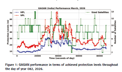
GAGAN exhibits HPL values typically between 9 m and 30 m, while VPL shows significant variability, occasionally exceeding 50–70 m. These characteristics constrain operations primarily to NPA and APV-I and are consistent with equatorial ionospheric challenges.
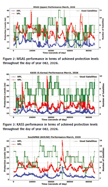
MSAS shows relatively stable but conservative protection levels, with HPL generally between 11–18 m and VPL around 17–30 m. Limited satellite usage restricts vertical performance and explains the absence of widespread APV-I or LPV operations.
KASS demonstrates HPL performance largely within 10–15 m and VPL typically between 18–30 m, with occasional short excursions. This behaviour aligns with APV-I and emerging LPV capability when assessed over longer time windows.
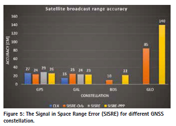
SouthPAN shows the strongest nominal performance, with consistently low HPL (6–10 m) and VPL (12–18 m). High satellite usage provides robust geometry, enabling LPV and LPV-200 operations.
For all above SBAS, the peak inflation of the protection level coincides with the geometry of the satellite (as indicated by the reduced number of used satellites). There are indeed other variables like the ionospheric and orbit & clock errors, which are not part this assessment.
2. Officially declared performance and supported procedures
GAGAN is officially certified for RNP 0.1 and APV-I with declared APV availability over most of the Indian landmass. MSAS supports en-route and limited terminal operations but does not declare APV-I or LPV nationwide. KASS officially supports RNP APCH including LPV with published horizontal and vertical alert limits of 40 m and 50 m respectively. SouthPAN is designed to support APV-I, LPV, and LPV200 and has published target VPL values below 35 m over its primary service region.
3. Space weather conditions on DOY 082, 2026
Day of Year 082 (23 March 2026) occurred under moderately unsettled geomagnetic conditions, with Kp values above 6 and geomagnetic storm G2. Therefore, the observed protection level variations are attributable to not only geometry, ionospheric modelling, and system design but also to a potential space weather impact.
4. Conclusions
The combined analysis shows strong consistency between declared system capabilities and observed performance. SouthPAN and KASS demonstrate readiness for advanced approach operations, while GAGAN and MSAS continue to fulfil essential regional safety roles for en-route and non-precision navigation. SouthPAN represents the benchmark for next-generation LPVcapable SBAS. KASS is rapidly maturing with credible LPV readiness, while GAGAN and MSAS remain operationally relevant for en-route, terminal, and APV-I or NPA services.
Notes on GNSS performances
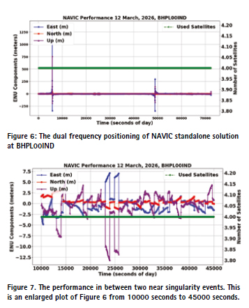
The regular performance monitoring of the GNSS constellation (for last two years, please refer to previous monthly issues) showed a stable and consistent SISRE performance. The bar plot shows the standard performance.
NAVIC System degradation
As reported by multiple technical news outlets and GNSS monitoring articles, the NavIC constellation experienced a significant degradation of standalone PNT capability from 13 March 2026 onward. In particular, this date marks the loss of continuous broadcast from PRN 06, which reduced the number of usable NavIC space vehicles below the minimum required for reliable standalone positioning.
4.3 BDSBAS (Shanghai Region)
BDSBAS demonstrated stable HPL/VPL values and low GIVEI even during storm peaks. The storm’s weaker impact over East Asia and BDSBAS’s dense monitoring network contributed to its strong robustness, the highest among all SBAS examined.
An analysis published in February 2026 (GNSS constellation-specific monthly analysis for January 2026, https://mycoordinates.org/gnss-constellationspecific-monthly-analysis-summary-january-2026/) examined the achievable positioning performance using NavIC-only, dual-frequency solutions. At that time, the constellation still provided at least four simultaneously visible satellites over the Indian service region, enabling meaningful PNT solutions. This condition remained valid until 12 March 2026.
NavIC-Only positioning performance prior to 13 March 2026
The dual-frequency NavIC-only positioning results showed that, for most of the day, reasonable horizontal and vertical performance could still be achieved, despite the reduced constellation size. The time series exhibited two pronounced error excursions per day, which were traced to near-singularity events in the geometry matrix. These events occurred when the effective satellite geometry became poorly conditioned, leading to temporary amplification of position errors.
Excluding these near-singular epochs, the remaining periods demonstrated comparatively stable solutions, confirming that NavIC, while degraded, was still capable of delivering limited standalone PNT performance up to that point.
Loss of PRN 06 Broadcast after 13 March 2026
From 13 March 2026 onward, PRN 06 ceased regular signal-in-space broadcast, and no longer contributed to navigation solutions. This event effectively reduced the operational NavIC constellation below the threshold required for standalone positioning, rendering NavIConly PNT operation impractical for most users.
Based on publicly available system status information and prior NavIC anomaly history, the most probable cause of PRN 06 unavailability is a payload-level anomaly, most notably related to on-board atomic clock performance or clock steering functionality. Similar clock degradations have affected multiple first-generation NavIC satellites in recent years, leading ISRO to periodically restrict or suspend navigation message transmission from affected spacecraft as a precautionary measure.
In such cases, the satellite may remain physically operational and trackable, but its navigation signal is marked as unusable or withdrawn entirely from service to preserve system integrity for remaining users. No evidence suggests an orbital failure; rather, the outage is consistent with clock-related or navigation payload integrity issues previously acknowledged within the NavIC programme.
Operational implications
The loss of PRN 06 eliminated the possibility of sustaining foursatellite NavIC geometry over the primary service region. As a result:
• Standalone NavIC PNT services effectively became unavailable from 13 March 2026 • NavIC performance degraded from a limited but usable state to insufficient constellation geometry
• NavIC’s role reverted primarily to:
▪ A supplementary ranging source in multi-GNSS receivers
▪ A supporting element for system monitoring and augmentation, rather than a standalone navigation system
Data sources and Tools:
https://cddis.nasa.gov (Daily BRDC, RINEX OBS); http:// ftp.aiub.unibe.ch/CODE_MGEX/CODE/ (Precise Products); BKG “SSRC00BKG” stream; IERS C04 ERP files
SBAS Mentor, ESA
gLAB GNSS, https://gage.upc.edu/en/learningmaterials/software-tools/glab-tool-suite
serenad-public.cnes.fr (SBAS data)


 (No Ratings Yet)


Leave your response!