
| GNSS News | |
GNSS
Galileo HAS ready to increase efficiency of farming tasks
In a collaboration between the European GNSS Service Centre (GSC) of EUSPA, Hemisphere GNSS and Case New Holland, experts from all entities tested the Galileo HAS service to assess its suitability for precision agriculture applications. The working width used for the test was 2.55 m, while the test area covered approximately 20,000 m² with a perimeter of about 740 meters. During the 3-hour test, the teams collected GNSS data to later analyse the pass-to-pass and absolute accuracy metrics. Pass-to-pass accuracy is the relative precision of a guidance system to maintain a consistent distance between adjacent, parallel machine passes within a short timeframe (usually 15 minutes). It is crucial for reducing gaps and overlaps during planting, spraying, and harvesting.
Test campaign
The test campaign aimed at proving that the tractor consistently maintained the specified path accuracy during consecutive passes. This would show that HAS can optimise agricultural operations by reducing costs associated with overlaps (reworking the same area), leading to savings such as reduced fuel consumption, minimal input waste and improved crop yield.
For the test setup, in addition to the onboard guidance system, an independent antenna was mounted on the tractor cab. This antenna was connected to two positioning solutions: one based on the Galileo HAS and another based on an RTK solution.
An RTK base station deployed for the occasion provided the rover with precise RTK corrections and enabled generating a “reference path” against which to compare the tested Galileo HAS, in this case based on corrections obtained directly from the Signal in Space (SIS) via the Galileo E6 band.
The driving was performed in automatic mode, with manual intervention required only for turning at the end of each pass. The autosteering system of the tractor would then automatically reconnect with the following path, as calculated at start-up.
Test results
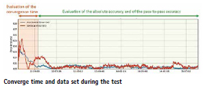
The test began with the GNSS receiver in Cold Start mode, requiring it to obtain ephemerides and process satellite data before achieving precise positioning. The convergence time was calculated and is shown as the red area in the image below. The green area shows when the tractor started along the predefined paths and hence when the data was used for the pass-to-pass accuracy calculation.
The data analysis showed that the Galileo HAS system consistently maintained horizontal errors of 3-6 cm.
With a 95% horizontal error of 5.9 cm and its maximum value below 8 cm, the error remains well below the 20 cm HAS accuracy target.
As regards the vertical axis, the 95% vertical error was 12.4 cm, with its maximum value below 25 cm, (remaining well below the 40 cm HAS accuracy target).
Galileo HAS signal vertical error The horizontal error of the HAS service relative to the RTK reference baseline is shown in the following figure.
Galileo HAS signal horizontal error Regarding the pass-to-pass accuracy, the analysis shows an overall pass-to-pass accuracy of 1.18 cm, demonstrating highly stable performance throughout the test period.
Year-to-Year accuracy was not part of this testing campaign but will be analysed in the next testing campaign.
The Galileo HAS service is an open, standardized correction service distributed directly via Galileo E6 or the internet (with global coverage) and the test campaign results confirm its potential to generate savings to farmers in terms of fuel consumption, fertilizers, seeds, and other inputs, by reducing overlap in field operations. www.euspa.europa.eu
Singapore launches digital twin playbook
The Infocomm Media Development Authority (IMDA) Singapore has launched the nation’s first Digital Twin for Enterprises Playbook, targeting the persistent challenge many organisations face: converting vast data streams into tangible value for their operations and growth.
The new playbook is intended as a stepby-step guide, walking business leaders through the process of identifying relevant digital twin use cases, evaluating data readiness, establishing robust governance frameworks, and executing projects with lasting business impact. The guide responds to a common pain point: while data collection is widespread, the leap from analysis to action remains elusive for many enterprises.
At the heart of the playbook is a clear explanation of what digital twins are and how they can be leveraged by businesses. Digital twins are virtual replicas of physical assets, systems, or processes, allowing teams to simulate real-world operations in a digital environment. The playbook distinguishes between asset, system, and process twins, and highlights two key uses: design and prototyping, as well as operational optimisation. For design purposes, digital twins enable companies to simulate and refine ideas before committing significant resources to physical builds. For process optimisation, these technologies can reveal inefficiencies and support continuous improvement.
The playbook also includes a framework to help organisations assess whether digital twin solutions align with their operational needs, business objectives, and current data maturity. This selfassessment is aimed at ensuring that investments in digital twins are both practical and impactful. A significant portion of the IMDA’s guide is dedicated to demystifying the technical foundation of digital twin deployments. It outlines the critical hardware required, such as sensors and Internet of Things (IoT) devices, which collect real-time data from physical assets. The middleware layer, including application programming interfaces (APIs), is explained as the glue that connects hardware to advanced analytics and visualisation software. On the software side, the guide covers platforms for analytics, artificial intelligence, and visualisation, illustrating how these components come together to create a functional digital twin.
Civil authenticated position fix under spoofing conditions achieved by Galileo
For two hours on the afternoon of Sept. 16, five operational Galileo satellites broadcasting over Europe transmitted a new encrypted signal for testing. On the ground in Andøya, Norway, and at ESA’s navigation laboratory at ESTEC, in the Netherlands, receivers successfully established their location using these encrypted signals, marking the first realworld positioning using Galileo’s upcoming Signal Authentication Service (SAS).
Satellite navigation has become essential in our lives, and consequently it has also become an increasingly attractive target for disruption. Interference with GNSS such as jamming and spoofing is reported daily in many regions, including in Europe, particularly in or near conflict zones.
One of Galileo’s most significant innovations is the Signal Authentication Service, that together with the already available Open Service Navigation Message Authentication (OSNMA) will unlock a new level of protection against interference.
The Signal Authentication Service is the result of the close cooperation between The European Commission (EC) defined the concept, while the European Space Agency (ESA) and the European Union Agency for the Space Programme (EUSPA) designed the architecture and updated the satellites and ground infrastructure to enable the new service on behalf of the European Union, Galileo’s owner.
Now, after extensive testing in laboratories and controlled environments, the new signal has proven its performance under real world conditions, at Jammertest. To establish a position, satellite navigation receivers work with two main pieces of data: the information sent by the satellites, known as the navigation message, and the ranging measurements, the time the signal takes to travel from the satellite to the receiver.
The Signal Authentication Service relies on encrypted ranging signals and is complemented by OSNMA, which enables receivers to confirm the navigation message originated in the Galileo system. OSNMA is operational since 2025 and represents Galileo’s first major upgrade to enhance its resilience to interference. www.esa.int
NASA tests FALCON technology
NASA’s Starling mission has marked another milestone in spacecraft autonomy by using a new system that determines a satellite’s position in orbit by referencing other objects in space, instead of relying on a navigational network.
The FALCON (Fast Autonomous Lost-inspace Catalog-based Optical Navigation) technology demonstration is a step toward spacecraft being able to operate more independently. As NASA prepares for more missions beyond Earth’s orbit, technologies like FALCON can support lunar satellite swarms, distributed science missions, and human exploration.
Traditional satellite navigation depends on GPS signals, but those can be unreliable or unavailable in lunar or deep space environments. The FALCON payload is a joint flight experiment by NASA and EraDrive, a startup spun out from Stanford University. It combines EraDrive’s Era-Core flight software and embedded algorithms with Starling’s cameras and an onboard catalog of known satellites to support GPS-independent navigation and space situational awareness.
The FALCON demonstration tested two complementary capabilities that made creative use of Starling’s onboard startracker cameras, standard instruments that identify bright objects in space to inform a spacecraft’s orientation and position. In position, navigation, and timing experiments, it matched objects that the spacecraft’s cameras observed – including other spacecraft and orbital debris – to a catalog of known space objects maintained and made publicly available by the U.S. Department of War. FALCON then used the observed and verified objects as reference points to determine Starling’s orbit.
In separate experiments, FALCON successfully refined the orbit estimates of the space objects observed by Starling’s cameras. The mission team loaded the full catalog of approximately 20,000 space objects and their predicted orbits onto the spacecraft. FALCON then correlated that data with the observations of other space objects made by the spacecraft’s cameras to estimate Starling’s location – and the locations of other space objects – with even greater precision than the current catalog data. During a three-day period, FALCON improved the known orbits of more than 200 objects without intervention from operators on the ground.
The self-orbit determination capability made possible through FALCON is a first for spacecraft using optical cameras to navigate by their relative position to other objects in space. Separately, the catalogupdate experiments produced better object position predictions onboard Starling than those provided by ground stations.
Coordinated networks of multiple GPSfree satellites will be critical to support surface operations for future human exploration of the Moon or Mars. For science missions, knowing the precise location of each spacecraft is necessary for aligning measurements taken from multiple points in space. And for space traffic management, autonomous navigation and catalog updates can reduce reliance on ground networks and enhance collision avoidance.
The FALCON experiment highlights NASA’s role in fostering commercial innovation. What began as a University SmallSat Technology Partnerships project evolved into a startup, EraDrive, that is now commercializing its EraCore software and related hardware for broader applications. www.nasa.gov







Leave your response!