
| His Coordinates | |
“Geodesy is often invisible to society, yet it underpins modern positioning, navigation, mapping, Earth observation, and environmental monitoring.”
— says Maj. Gen. (Dr.) B. Nagarajan. As India modernises its geodetic infrastructure and expands its geospatial capabilities, he explains why geodesy has become central to scientific research, national development and infrastructure resilience. |
 |
|
After spending several decades with the Survey of India and now serving in academia, how has your perspective on geodesy and its role in national development evolved?
Geodesy in India historically evolved through institutions such as the Survey of India, where the primary focus was national mapping, triangulation, datum establishment, and boundary definition. The classical Everest Datum and the Great Trigonometrical Survey formed the backbone of India’s geospatial infrastructure for several decades.
Today, the discipline is gradually transitioning from purely operational surveying toward research-driven geodesy within universities and scientific institutions. Academic groups are now actively working on GNSS geodesy, crustal deformation, atmospheric sensing, sea-level studies, gravity field modeling, and satellite geodesy. This transition represents a shift from static mapping toward dynamic Earth system monitoring. Modern geodesy now integrates geophysics, remote sensing, atmospheric science, hydrology, and space science.
Institutions such as IIT Kanpur and the National Centre for Geodesy are helping bridge operational and scientific geodesy.
The emergence of continuous GNSS networks has further accelerated this transformation. Young researchers increasingly view geodesy not merely as surveying, but as a quantitative Earth observation science. This evolution is essential for India’s future needs in infrastructure development, climate studies, and geohazard monitoring.
How would you assess the current status of geodesy in India, and how does it compare with developments in other parts of the world?
Globally, geodesy has rapidly advanced through space-based systems such as GNSS, DORIS, SLR, VLBI, InSAR, and GRACE. Countries in Europe, the United States, China, and Japan operate dense geodetic observing networks with real-time analysis capabilities. India has made significant progress through initiatives such as GNSS-CORS networks, NavIC development, and crustal deformation studies.
However, compared to leading global geodetic programs, India still faces limitations in network density, data integration, and long-term coordinated infrastructure. Many Indian geodetic datasets remain fragmented across institutions. Real-time geodetic products and national-scale geophysical integration are still under development. There is also limited visibility of geodesy within mainstream scientific and policy ecosystems. At the same time, India possesses major strategic advantages due to its tectonic setting, monsoon dynamics, equatorial ionosphere, and extensive coastline. These conditions provide globally important natural laboratories for geodetic research. With coordinated national programs, India can emerge as a major contributor to global Earth observation science.
Why is India’s transition from the Everest Datum to a modern geocentric reference frame so important, and what are its practical implications?
The Everest Datum served India for many decades and was designed primarily for classical terrestrial surveying. It was locally optimized and not fully geocentric, making it incompatible with modern satellite positioning systems. The introduction of GNSS fundamentally changed positioning science by requiring Earth-centered global reference frames such as ITRF and IGS. India is therefore transitioning toward modern geocentric coordinate systems compatible with GPS, Galileo, GLONASS, BeiDou, and NavIC. This shift is essential for precise navigation, deformation monitoring, and satellite orbit determination.
Modern geodesy requires millimeter-level consistency across space and time. Horizontal and vertical datums adopted decades ago no longer satisfy present-day scientific and engineering requirements. Geocentric frames also allow integration of Indian observations with global geophysical datasets. The transition is not merely technical; it represents a conceptual change from static mapping to dynamic Earth monitoring. Institutions such as the National Centre for Geodesy play an important role in supporting this modernization effort.
Despite its importance, geodesy often remains behind the scenes. Why do you think it has not received the visibility it deserves in India’s geospatial ecosystem?
Despite its strategic importance, geodesy often receives less visibility compared to fields such as remote sensing, artificial intelligence, or space exploration. Many decision-makers interact with geodetic products daily without recognizing the underlying science. Accurate positioning, navigation, mapping, infrastructure monitoring, and disaster assessment all depend on geodesy. India’s rapid infrastructure growth makes highprecision geodetic frameworks increasingly important. However, geodesy remains underrepresented in university curricula and interdisciplinary programs. Funding and institutional visibility are also relatively limited compared to its national importance. Awareness is gradually improving through CORS initiatives, satellite missions, and GNSS applications. The increasing use of drones, autonomous systems, and precision agriculture is also expanding its relevance. National programs can further strengthen visibility by linking geodesy to societal applications and national development goals. A stronger geodetic ecosystem is essential for scientific sovereignty and future geospatial independence.
How have satellite technologies and other recent technological advances transformed the practice of geodesy in India?
Modern geodesy has been transformed by satellite and computational technologies. Continuous GNSS observations now allow real-time monitoring of crustal motion and atmospheric variability. InSAR enables centimeter- to millimeter-scale surface deformation mapping over large regions. Satellite gravimetry missions such as GRACE provide insights into groundwater changes and mass redistribution. Cloud computing and high-performance processing have dramatically increased data handling capabilities. Geodesy today is increasingly multidisciplinary and data-intensive.
In India, technologies such as NavIC, dense CORS networks, and low-cost GNSS receivers are expanding observational capabilities. Modern software environments also enable automated processing pipelines and large-scale analysis. Integration between geodesy, GIS, atmospheric science, and geophysics is becoming increasingly routine. These technological transformations are redefining geodesy from a surveying discipline into an Earth system science.
Artificial intelligence and machine learning are reshaping many scientific disciplines. How do you see these technologies influencing the future of geodesy?
Artificial intelligence and machine learning are becoming increasingly important in geodesy. AI methods can help detect anomalies, classify signal quality, and identify subtle geophysical patterns within large datasets. In GNSS applications, machine learning can support multipath detection, TEC modeling, ambiguity quality assessment, and data gap handling.AI is also useful for deformation pattern recognition in GNSS and InSAR time series. Large national geodetic networks generate massive datasets that are difficult to analyze manually. Machine learning therefore provides powerful tools for automation and predictive modeling. However, geodesy remains strongly physics-based, so AI must complement—not replace—physical understanding.
In India, AI can help optimize CORS networks, improve atmospheric modeling, and enhance disaster monitoring systems. There is also strong potential for integrating geodetic and environmental datasets for climate-related studies. The future likely lies in combining physical geodetic models with intelligent data-driven systems.
India has relatively few trained geodesists. How serious is this challenge, and what steps are needed to build the required human resources?
One of the major challenges in India is the limited number of formally trained geodesists. Many universities do not offer dedicated geodesy programs or advanced satellite geodesy training. As a result, expertise is often concentrated within a few institutions and specialized research groups. Modern geodesy requires knowledge of mathematics, physics, satellite systems, computation, and Earth science simultaneously. This interdisciplinary nature makes training demanding but also highly valuable.
There is a growing need for experts in GNSS processing, reference frames, gravity modeling, and geodetic data science. The expansion of CORS networks and geospatial technologies will further increase this demand. Young researchers often enter geodesy indirectly through remote sensing, geophysics, or civil engineering backgrounds. Strengthening academic curricula and national training programs is therefore essential. Developing human resources may ultimately be more important than developing instrumentation alone.
What role do you see the National Centre for Geodesy playing in advancing geodetic research, education, and national geodetic infrastructure?
The National Centre for Geodesy has the potential to become a central platform for advancing modern geodesy in India. Its role extends beyond data collection toward national coordination, standards, training, and scientific leadership. NCG can help unify fragmented geodetic efforts across institutions and agencies. It can support the development of consistent national reference frames and integrated observing systems. The Centre also plays an important role in promoting research in GNSS geodesy, gravity studies, crustal motion, and atmospheric applications.
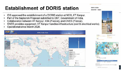
Capacity building and student training are equally important responsibilities. NCG can act as a bridge between operational agencies, academia, and international geodetic organizations. It also provides an opportunity to strengthen India’s contribution to global geodetic infrastructure. Long-term continuity and open scientific collaboration will be key to its success. To promote geodesy education and research in India, several Regional Centres for Geodesy (RCGs) have also been established at IIT Bombay, IIST Thiruvananthapuram, Anna University Chennai, MANIT Bhopal, MNNIT Prayagraj, and ISM Dhanbad under the broader framework of NCG supported by the Department of Science and Technology, Government of India.
How important is international collaboration for India’s geodetic programme, and what benefits does it bring?
Geodesy is fundamentally a global science because Earth systems do not follow national boundaries. Reference frames, satellite orbits, sea-level studies, and tectonic processes all require international coordination. Organizations such as the International GNSS Service (IGS) and the International Association of Geodesy (IAG) provide essential global frameworks. India benefits greatly from participation in these international scientific collaborations. Global data sharing improves reference frame accuracy and scientific reliability. International partnerships also provide access to advanced methodologies and training opportunities.
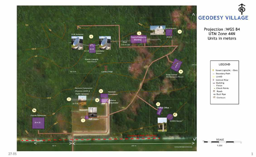
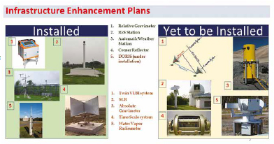
For India, collaborations are especially important in areas such as ionospheric science, crustal deformation, sea-level monitoring, and gravity studies. Joint projects help ensure compatibility between Indian and global geodetic products. They also increase the international visibility of Indian research. To strengthen participation in international geodetic missions, a Geodesy Village incorporating techniques such as VLBI, GNSS, DORIS, SLR, InSAR, quantum gravimetry, and timefrequency standards is being developed at IIT Kanpur.
Looking ahead, what is your vision for the future of geodesy in India over the next decade?
Over the next decade, India has the opportunity to build a fully integrated modern geodetic infrastructure. This includes dense multi-GNSS CORS networks, modern geocentric reference frames, gravity infrastructure, and real-time geodetic services. Integration of NavIC with global systems will strengthen national positioning capabilities. Geodesy will increasingly support climate monitoring, groundwater studies, disaster management, and smart infrastructure. AI-driven processing and automation will improve scalability and operational efficiency. Open-data policies and coordinated national frameworks will be important for scientific growth. Training the next generation of geodesists must remain a central priority.
India can also become a global leader in low-latitude ionospheric and monsoon-related geodetic research. Closer integration between academia, government agencies, and industry will accelerate progress. The ultimate vision is for geodesy to become a core national scientific infrastructure supporting both science and society.
Finally, what message would you like to leave for policymakers, researchers, and young professionals about the future of geodesy in India?
Geodesy is often invisible to society, yet it underpins modern positioning, navigation, mapping, Earth observation, and environmental monitoring. India stands at an important stage where traditional surveying foundations are converging with advanced space-based geodesy. The combination of modern technology, scientific collaboration, and national institutional support creates a major opportunity for growth.
At the same time, challenges remain in awareness, training, infrastructure integration, and sustained longterm investment. The National Centre for Geodesy can play a transformative role in addressing these gaps. India’s unique geographic and geophysical setting gives it exceptional scientific importance within global geodesy.
Future progress will depend not only on instruments and satellites, but also on developing strong scientific communities. Geodesy is increasingly becoming a key component of Earth system science and national infrastructure resilience. With coordinated vision and sustained effort, India can emerge as a major global contributor to modern geodesy. The coming decade may therefore represent a defining phase for geodesy in India.







Leave your response!