| GNSS | |
European Radionavigation Plan and the proposed EU Complementary Positioning, Navigation and Timing (C-PNT) Ecosystem
By establishing an EU PNT ecosystem that incorporates C-PNT technologies, we can enhance PNT resilience, availability, and continuity |
 |
|
 |
|
 |
|
 |
|
Introduction
Global Navigation Satellite Systems (GNSS) including Galileo and the European Geostationary Navigation Overlay Service (EGNOS), are widely regarded as the underpinning of the modern Position, Navigation and Timing (PNT), continuously providing time and position services across the globe. This service is essential to many economic sectors of our modern society, including transport (air, sea, and road), industry (telecommunication, energy, and finance), agriculture, fisheries, as well as security and defence.
According to the European Radionavigation Plan (ERNP) [1], over 10% of European Gross Domestic Product (GDP) is now enabled by economic activities underpinned by satellite navigation systems. The trends suggest that this will continue to increase, putting a premium on the uninterrupted delivery of PNT services.
Despite its technological excellence, GNSS can be subject to local (jamming/ interference) or global (space weather, system fault) outages, and it is also unable to deliver full service in areas of limited sky visibility. With the widespread role of GNSS as the sole (or at least primary) source of PNT, it is important to consider other platforms or systems providing PNT, able to complement or backup GNSS services.
Alternative PNT Test Campaign
In December 2020, the Directorate General for Defence Industry and Space (DEFIS) of the European Commission (EC) launched the call for tender (CfT) DEFIS/2020/ OP/0007 with three main goals:
• Assess the performance of A-PNT technologies to deliver positioning and/or timing information independently from GNSS and ideally extending the provision of PNT in environments where GNSS services cannot be delivered;
• Understand the requirements for the EU deployment
• Provide inputs to the ERNP[1].
The Joint Research Centre is a part of European Commission and provides independent, evidence-based knowledge and science support to EU policies. JRC supports DG DEFIS and EUSPA on a wide set of topics related to Galileo and EGNOS. JRC supports the development of services, reference documents describing the service, publicly available through the Galileo Service Centre website and support R&D activities Horizon Europe and Galileo Fundamental Elements R&D Actions. Part of this work exploits JRC extensive laboratory expertise [4] providing expert support, developing test vectors or related testing.
Given this extensive knowledge JRC was best suited to manage the test campaign. The majority of testing activities were conducted at the Ispra site, located in Northern Italy. The timing testing was conducted in the dedicated labs, the indoor positioning was conducted in two buildings and outdoor positioning testing across the site in three different environments (open, woodlands, and urban). Testing required extensive infrastructure installation and network access, which were organised for each platform separately. This included the installation of transmitting equipment around the campus and temporary licenses granted by the IT Spectrum Regulator for one of the participants.
JRC have utilised dedicated reference platforms for testing
: • For timing, the assemble of GNSS receivers and Rubidium atomic clock was calibrated by the Istituto Nazionale di Ricerca Metrologica (INRiM);
• For position, of the moving IMU and GNSS unit or, for indoors, total station tracking was used.
Key Performance Indicators
The Key Performance Indicators (KPIs) were defined by the tender as follows:
• Ability to deliver positioning and/or timing information independently from GNSS, in Universal Time Coordinated (UTC) for time and in European Terrestrial Reference System 89 (ETRS89), respectively) for position;
• Acting as a backup in the event of a GNSS disruption or outage;
• Providing coverage for the EU European territory, including in-land waters;
• Being resilient to GNSS failure modes and vulnerabilities (including GNSS frequency jamming and spoofing or unintentional interference);
• Having a TRL greater than 5 for position/navigation services OR greater than 6 for timing services;
• Providing a minimum performance of the alternative PNT service for at least 1 day upon GNSS loss, i.e.: (i) Positioning Accuracy (Horizontal and/or Vertical at 95%) < 100 m OR Timing Accuracy to UTC (99.7%) < 1 microsecond with (ii) Availability > 99%.
The KPIs were assessed after 1 day, 14 days, and 100 days of GNSS services loss. Additionally, systems were expected to provide position and/or time information in environments where GNSS cannot be efficiently delivered, including urban canyons, indoor, underground, underwater, and for fast-moving platforms such as spacecraft and launchers.
Participants were also asked to provide a description of the possibility to deploy the services on a local, regional, or continental scale.
Technologies Under Test
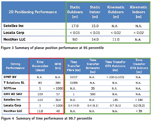
Out of seven participants, four demonstrated timing services (OPNT, 7 Solutions SL, SCPTime and GMV), and remaining three (Satelles, Locata Corporation, and NextNav) demonstrated both positioning and timing services, as presented in the table below. Six contractors were selected through the DEFIS/2020/OP/0007 with NextNav approaching independently and tested in the same regime.
Given the tight timetable, COVID restrictions as well as financial burden to contractors, some of the tests were conducted in sites across EU and US, as indicated by the table below.
Each participant agreed specific tests plans for timing and three of them also for position testing. A demonstration of platform resilience to external threats, system monitoring and other cybersecurity element understand each technology. [2] provides in-depth description of tests while [3] describes additional candidate technologies, not covered by the testing campaign.

Results of the JRC Test Campaign
The test campaign firstly aimed to understand the maturity and readiness of A-PNT technologies for operational use, and secondly, to assess the performance of the proposed PNT platforms against common baseline KPIs. This was in line with the objective of understanding the advantages and limitations of each provided solution and developing the future EU PNT vision.
Due to the diverse nature of the tested technologies, the results should not be directly compared; instead, they should be regarded as individual assessments of each solution.
Overall, each participant fulfilled the required KPIs. Three PNT technologies tested were able to provide meters level position, with notable cm level performance from Locata. All seven technologies provided time transfer well below nanosecond, with notable White Rabbit sub-ns performance (OPNT and 7Solutions) and ns level performance from Locata. It should be noted that EU companies exhibited an excellent record in the time transfer. Additionally, multiple Master Clock inputs with voting and seamless switchovers were demonstrated by OPNT, Seven Solutions, and Locata.
Similarly, each demonstrated stringent cybersecurity performance. This includes secure remote access to hardware, over-the-air updates, whole network monitoring, and reporting. Hardware also deploys modern programming techniques such as virtualization, allowing for rapid deployment and updates if required. Some critical elements (including operation mode and implementation) cannot be captured by KPI metrics, and simplifications were made for the sake of the assessment.
The Achilles heel of those technologies is the UTC reference (captured above as Maximum Time Interval Error (MTIE) and Time Generation values) which could also be read as time generation performance without GNSS. Without precise atomic clocks (as demonstrated by 7Solutions and GMV), a connection to National Metrological Institute (NMI) (OPNT), or both (Satelles), it was not possible to extend this capacity beyond a few days.
The results highlighted the important role of NMIs across Europe and identified that GNSS serves as the foundation for PNT services and is expected to continue doing so in the future, as no other technology can match its performance at this price point to end-user. Nevertheless, the platforms tested have demonstrated the capacity to provide time and position in areas of limited sky visibility that limits GNSS.
European Radio Navigation Plan
The ERNP 2023 [1] is a European Commission staff working document, written by DG DEFIS in cooperation with the DG Joint Research Centre (JRC). The document was mandated in the 2016 Space Strategy for Europe and its first edition was released in March 2018. The current 2023 edition is its second and it was expanded to address the following aims:
1. Provide information on conventional and emerging PNT systems and services, their use, typical performance, strengths, weaknesses, developments, trends, challenges, and opportunities.
2. Facilitate the uptake of the European GNSS (Galileo and EGNOS) services by:
▪ Providing detailed information on European GNSS current and future services and their added value;
▪ Recommending EU level actions for the uptake of EGNSS across market domains/sectors, including legislation and standards.
3. Recommend actions to increase the resilience of PNT services in the EU and explain the EU PNT policies while summarizing international ones.
4. Outline the medium-term vision of EU PNT evolution based on the COM exercise (2022-2023), inputs from stakeholders and the A-PNT Test Campaign described above. This is an outlook and not yet an agreed policy.
The conclusions of the test campaign were used to define the last point. The campaign allowed a better understanding of the possible evolution of the landscape of PNT infrastructures in the EU, including new emerging systems.
Towards C-PNT vision
Before the JRC Test Campaign described above, the assumption was that new emerging systems could act on their own, providing an alternative source of PNT that is able to deliver positioning and/or timing information independently from GNSS. Hence, the A-PNT indication.
However, as discussed, this was found to be a sub-optimal approach. Firstly, the tested technologies have demonstrated complementing capacity, both to each other and GNSS. Secondly, UTC required the connection to the external atomic clock (or NMI), something that could be fulfilled by GNSS. Thirdly, if systems were to be utilized coherently, they could provide another independent source of information, hence increasing the overall resilience more than an independent system could do on its own, as long as a common reference exists
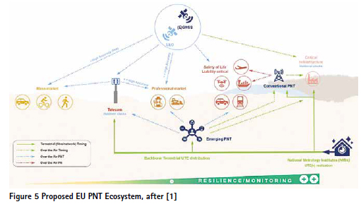
. Based on the above findings, ERNP [1] suggests the most optimal approach is the system of systems approach (SOSA). This would consist of space and terrestrial assets, as presented in the figure below.
The proposed ecosystem is composed of multiple autonomous systems that share a common time and position reference frame (UTC and ETRS89, respectively). For this purpose, both terrestrial and space assets are underpinned by GNSS for UTC, with additional EU terrestrial backbone providing independent UTC. This creates increased resilience and monitoring for Critical Infrastructure (CI), as well as creating infrastructure which can be utilized for safety of life and professional markets, and with time extended to the mass market applications. This approach also allows for the gradual extension of the PNT service, without disturbing the existing provision, while allowing for a greater participation of commercial entities. Future interconnectivity is regulated by the common time and position reference frame.
Within this system of systems approach (SOSA), the non-GNSS components would be best referred to as Complementary (Continuous) PNT (C-PNT), given their aim to provide resilience, extend PNT to environments that cannot be served by GNSS, and also function as limited spatial and temporal backup systems supporting existing infrastructure.
Conclusion
The need for C-PNT technologies in Europe is a testament to the indispensable role of Galileo and EGNOS. Our reliance on GNSS services is so great that it is essential to have both backup and alternative systems in place to mitigate the risk of PNT service interruption. By establishing an EU PNT ecosystem that incorporates C-PNT technologies, we can enhance PNT resilience, availability, and continuity, thereby strengthening EU autonomy, resilience of the economy, and through technical development also EU’s global standing.
The candidate C-PNT technologies description can be found in [1], [3], with latter also proposing EU PNT Ecosystem, supported by the results of the 2021-22 A-PNT Test Campaign summarised in [2]. It also concluded that a resilient EU PNT requires a system of systems approach with a mix of technologies, supported by industry standards to ensure the required interoperability. The proposed first step should be to provide the timing backbone by interconnecting European NMIs, with further steps including investigation on the feasibility of dedicated terrestrial spectrum for C-PNT use and how it could be integrated/standardized in devices. It is essential that the EU prioritize the development and implementation of C-PNT technologies, as described in [3], to ensure the continued reliability and stability of its PNT services.
This article expands further on the vision presented in [1] and describes the EU PNT ecosystem based on the system of systems approach (SOSA), underpinned by GNSS. It should be noted that the EU PNT ecosystem is a proposal and not a policy.
It is worth noticing that the European Commission has also undertaken regulatory actions aimed at enhancing the resilience of PNT infrastructures and services in the EU. The main policy actions addressed include the EU Space Programme Regulation, the update of the EU CI and Network Information Systems (NIS) Directives, and the publication of a Commission Staff Working Document defining the use of EGNSS for timing and synchronization in CI.
References
[1] European Commission; 2023. European radio navigation plan 2023. Publications Office of the European Union.
[2] Bonenberg, L., Motella, B. and Guasch, J.F. 2023. Assessing alternative positioning, navigation and timing technologies for potential deployment in the EU. Publications Office of the European Union.
[3] Bonenberg, L., Motella, B., Paonni, M., Fortuny-Guasch, J. and Alcantarilla-Medina, I. 2023. Backing up GNSS. Inside GNSS. 18, 4 (2023), 48–55.
[4] Cucchi, L., Gioia, C., Susi, M., Damy, S., Bonenberg, L., Boniface, K., Basso, M., Sgammini, M., Paonni, M. and Fortuny Guasch, J. 2021. JRC testing and demonstration hub for the EU GNSS programmes. Technical Report #KJ-NA-30747- EN-N (online). Publications Office of the European Union.
The reports [1],[2] discussed in this article are available from https://joint-researchcentre. ec.europa.eu/scientific-activities-z/ complementary-and-alternative-pnt_en.


 (2 votes, average: 3.50 out of 5)


Leave your response!