| Applications, Disaster Management | |
Development of geospatial and space technologies for disaster management platform
This article presents a study project on collaborative schemes of geospatial and space technologies for disaster risk management (DRM) in the ASEAN region to establish a platform facilitating sustainable operations of the technologies and services |
 |
|
Resilience of social infrastructure has been considered important for economic growth of Asia as well as the ASEAN region. For example, the 2011 Great East Japan Earthquake and the 2011 Flood in Thailand left enormous damages of human resources, industry, and economics in the disaster affected regions. The Asia region has experienced 150 large-scale disasters (equivalent to 40% of largescale disasters in the world), 200 million of victims, and economic damages of 41.6 billion US dollars per year between 2000 and 2010 (Sawada and Zen 2014). Particularly, the area of the ASEAN Member States is the most affected by disasters in the world (Sawada and Oum 2011). Therefore, strengthening resilience to natural disasters is an urgent issue in the ASEAN region.
In aftermath of Sumatra Earthquake and Tsunami in 2004, the ASEAN Agreement on Disaster Management and Emergency Response (AADMER) was ratified by all 10 member states and entered into force in December 2009. AADMER Work Program 2010-2015 was developed to cover all aspects of disaster management and outlined a detailed road map for four components of disasters: (i) risk assessment, early warning and monitoring, (ii) prevention and mitigation, (iii) preparedness and response, and (iv) recovery. The ASEAN Committee on Disaster Management (ACDM), which comprises national disaster management agencies of participating countries, is an implementing body of the AADMER in collaboration with ASEAN and other countries as well as international organizations.
Although a lot of studies indicated that geospatial technologies and space technologies have notable potentials to strengthen the resilience, sustainable mechanism for integrating the technologies in practice for disaster risk management (DRM) has not still been well established (Miyazaki et al. 2015). A study project conducted under Economic Research Institute for ASEAN and East Asia (ERIA) pointed necessities of (i) trans-border mechanism to deliver the geospatial and space-based information from data provider to end users in disaster-affected areas with support of international activities and (ii) financial schemes involving private sectors, or public-private partnerships (PPP), to operate collaborative integration of the technologies in sustainable and practical manners.
The University of Tokyo and Japan Space Forum started a study project on this issue under ERIA in June 2016 with a support of Cabinet Office, the Government of Japan. This article is to present scheme of the study project and perspectives of the outcomes.
An Envisaged Sustainable Scheme of DRM Information Service in ASEAN Region
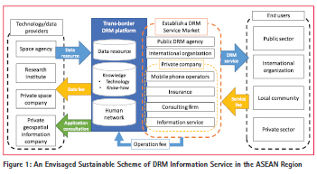
In the study project, a trans-border DRM platform in the ASEAN region was proposed to establish a transborder mechanism with PPP scheme in a sustainable manner (Figure1). The platform comprises the following components.
(a) Data resource—Resources of necessary information for DRM, such as satellite data, geographic data, meteorological data, ground stations, socioeconomics data, and demographic data. The data resources shall be virtually connected by standardized protocols and infrastructure among data archives and real-time streams from several technology providers rather than a single provider. Because geospatial and space technologies have potentials in international expansion, we especially highlight data resources which are available and extensible in regional and global scale, such as GNSS and earth observation.
(b) Knowledge—Technology itself is a sort of knowledge. In addition, DRM needs knowledge on how to apply the technologies in practice, such as institutionalization, stakeholders’ cooperation, local community participation, and local capacities and resources regarding the technologies. Good practices should be studied well so that following projects can apply the knowledge. DRM experts may contribute to the platform to produce and share knowledge products with the stakeholders. Also, the knowledge products will be used for capacity development of human resources that can create DRM solutions using geospatial and space technology in the ASEAN region.
(c) Human network—Practical DRM consists of collaborations among local and international experts of monitoring, data acquisition, data management, science, visualization, and DRM. In addition, it should need local stakeholders cooperation as end users of the DRM technologies and services, with which various kinds of stakeholders shall participate in implementations. For efficient coordination among experts and stakeholders, the platform shall provide directories of experts, government officers, and local community leaders participating in DRMs. Online/ offline forums shall be considered to promote efficient coordination for development of DRM practices.
The platform shall work as DRM service infrastructure for public disaster management agencies and private companies, such as mobile phone operators, insurance companies, consulting firms, and information service companies. While the service providers develop businesses using the infrastructure, the platform collect operation fees from the service providers to ensure sustainable operations of the platform and data resources from the technology providers. This scheme will help to ensure sustainability in operations of the technology providers and service providers by the finances facilitated by the platform.
Steps to Design the Platform
The study project aims to (i) analyze feasibility of the proposed platform in terms of technology and finance and (ii) design and prototype the platform based the feasibility study. This study is structured by three steps: (a) collection and development of core examples; (b) design of the transborder platform; and (c) design of the financial arrangements. Details of each step are described in the following.
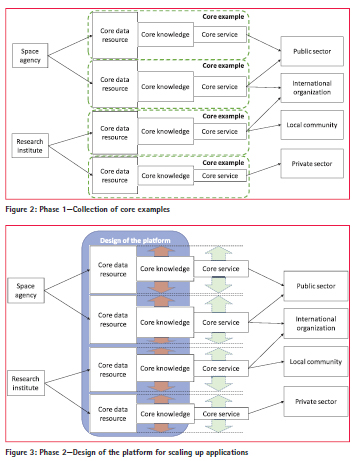
(a) Collection, Design, and Development of Core Examples
The project will conduct exhaustive case studies of DRM activities and supporting data resources (e.g. GNSS and earth observation) and practical knowledge through literature reviews and interviews to stakeholders (e.g. operating body and end users) to identify essential requirements of the platform to be designed base on practices. Another approach is organizing existing technologies and know-hows into consistent DRM services as core examples of the platform. To collect such examples efficiently and quickly, the project will hold workshops with data providers, service providers, and end users to discuss DRM applications of global and regional data resources.
There shall be an assumption that the core examples are scalable to other cities, provinces, and countries by the trans-border feature of geospatial and space technologies. The analysis of the core examples will be by data resources, knowledge, and services to investigate how much the core examples are scalable by the trans-border basis.
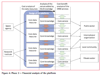
(b) Design of the Platform
Through reviews of collected core examples, the platform will be designed with requirements which enable scaling up applications by the shared data resources and knowledge. The design shall include and not limited to: (i) technical interoperability of the data resources and technology, (ii) partnerships with data providers, and (iii) participation of local, national, and international stakeholders who has interests in the core examples
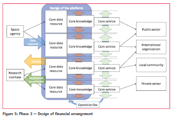
(c) Design of the Financial Arrangements
A financial analysis of the designed platform will be conducted to assess feasibility and sustainability, such as operational cost of data resources, cost-benefit of the services, and analysis of added values by scaling up applications (Figure 4). The analysis will help to draw short- and longterm strategy of operating the platform in sustainable manners. The analysis results are expected to be basis of the financial arrangements among the stakeholders, such as corporation between data provider and the platform and another one between service provider and the platform.
Expected Outcomes and Perspectives
(a) Core examples collected, designed, and developed
This study project will involve some groups who are working for DRM applications of geospatial and space technologies as core examples. The core examples will be classified and shared as data resources, knowledge, and services. The study project also will attempt to combine the components to create new core examples applicable to DRM in the ASEAN region.
(b) Technical design of the platform
The platform shall be designed with technical specifications which are identified by the analysis of the core example comprising data resources, knowledge, and services. The design shall include technical requirements to promote collaborations among core examples, such as inclusion of standardized protocols and infrastructure. Also, the design shall include technical perspectives to scale up the core knowledge and services as broad as a geographical extent that the core data resources supports.
(c) Financial design of the platform
Financial arrangements needed for establishment of the platform will be designed based on results of the analysis on costs and benefits between the data resources and services, and added values by the knowledge. The design will support to develop strategies of collaborations with development agencies who would have interests in DRM technologies and its applications, such as the World Bank and the Asian Development Bank, the main players of promoting mainstreaming DRM in development projects. The design also will help to facilitate dialogues within the ASEAN member states to finance for sustainable operation of the platform.
(d) Strategy for development and operation of the platform
The project will draw short- and long-term strategies of development and operation of the platform based on the technological and financial design. The strategy shall include collaborations with partners, such as the core example participants comprising the ASEAN member states, technology providers, stakeholders, and financial partners, such as international development agencies and bilateral assistance schemes. Therefore, the strategy shall be consistent with partners’ resources and strategies. The strategy also shall include measurable goals in disaster reduction which can be achieved by establishment of the platform.
Conclusion
This article presented a study project on collaborative schemes of geospatial and space technologies for DRM in the ASEAN region to establish a platform facilitating sustainable operations of the technologies and services. The study project is ongoing to seek core examples through literature reviews and consultations with DRM stakeholders (as of February, 2017). The collected core examples will be complied into a design of the platform to share the good practices for strengthening resilience of the ASEAN region.
References
Miyazaki, H., Nagai, M. and Shibasaki, R. (2015) Reviews of Geospatial Information Technology and Collaborative Data Delivery for Disaster Risk Management. ISPRS International Journal of Geo- Information, 4(4), pp. 1936-1964.
Sawada, Y. and Oum, S. (2011) Economic and Welfare Impacts of Disasters in East Asia and Policy Responses. Economic and Welfare Impacts of Disasters in East Asia and Policy Responses. ERIA Research Project Report, 8, pp. 1-25.
Sawada, Y. and Zen, F. (2014) Disaster management in ASEAN. ERIA Discussion Paper Series No. 2014- 03: Economic Research Institute of ASEAN and East Asia.


 (No Ratings Yet)


Leave your response!