| Mycoordinates | |
Demeter micro-satellite
|
|||||||||||||||||||||||||||||||
|
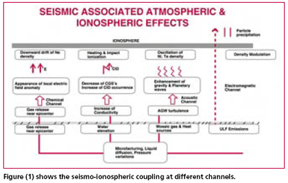
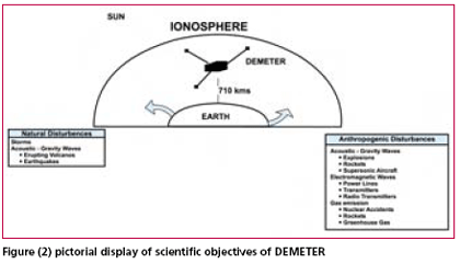
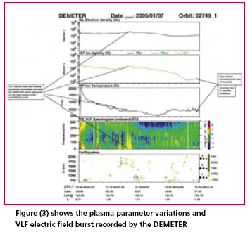
Early warning of earthquakes has actually become the main goal of seismology. And though seismic prediction started as a purely seismological discipline, it now involves hydrology, hydro -geochemistry, measurement of telluric and magnetic fields etc. The parameters under observations for the purpose of diagnosing seismic regimes include hydro -chemical parameters, atmospheric electrical disturbances, electromagnetic emissions, anomalous disturbances in the ionosphere and the magnetosphere recorded by satellite. Among different precursory phenomena mentioned in the different publications on the predictions the ionospheric predictions are probably the youngest due to its unique ability to indicate the approximate position of the earthquake epicenter using ground and space-based observations. The study of seismicity and underlying processes could be essentially improved by using the satellite methods, as it happened with climate and weather study, when proper satellite information are made available. Local probes installed onboard artificial satellites are able to register the variations of near-earth plasma parameters associated with the preparing earthquakes. Probably, the first report on the satellite measurements of ionospheric precursors of the earthquakes could be attributed to the beginning of 1980s. Conditionally, the precursors observed by satellites can be divided into following groups i) Electromagnetic fields and noises; ii) Plasma parameters variations; iii) Particle fluxes. Electromagnetic emissions in the low frequency ranges that are related toseismic activities are known since long time, but their generation mechanisms are not well understood. Two types of emissions can be considered; first, precursor emissions occur a few hours before earthquakes in a large frequency range from one-hundredth hertz up to several mega hertz; secondly emissions observed after the shock generally are attributed to the propagation of acoustic-gravity waves (Pokhotelov et al., 1995 and Parrot et al., 2002) However, all hypothesis concerning the generation mechanism of precursor emission are also valid after the shock, when Earth’s crust returns to the equilibrium state. The emissions can propagate up to the ionosphere; and observations made with low – altitude satellites have shown variations of low frequency waves above seismic regions. The above mentioned points can be well understood through the block diagram given in Figure (1) which gives the seismo-ionospheric coupling and thereby atmospheric and ionospheric effects at different channels. Substantial progress has been made in developing the methods for earthquakes hazards analysis on a timescale in DEMETER Micro-satelliteDEMETER Satellite is the first of its kind developed by the CENTRE NATIONAL D’ETUDES SPATIALES (CNES), France and launched on 29 June, 2004 from Baikonour, Kazakhstan .The scientific objectives of DEMETER are related to the investigation of the ionospheric perturbations due to the seismic activity, and also to the global study of the Earth electromagnetic environment. The main objectives of the DEMETER experiments are to study the disturbances of the ionosphere caused due to the seismo-electromagnetic effects , and due to anthropogenic activities as shown in Figure(2). There are two modes of operation: – (a) A survey mode to record low bit rate data all around earth; and (b) A burst mode to record high bit rate data above seismic regions. Sensors are associated to an electronic block in order to digitize the signals and to perform onboard data processing. · ICE (Instrument Champ Electrique), Measurement of quasi-continuous electric fields and the electric components of waves, three electric sensors from DC up to 3.5 MHz; · IMSC (Measuring the magnetic components of waves), three magnetic sensors for measuring magnetic field from a few Hz up to 18 kHz; · IAP (Instrument Analyseur Plasma), measurement of plasma parameters, an ion analyser; · IDP (Measurement of energetic particle spectra), an energetic particle detector; and · ISL (Measurement of the characteristics of thermal plasma), a Langmuir probe. Proposed Ionospheric parameters for measurementBased on retrospective analysis of existing satellite measurements of seismo-ionospheric variations and existing models, the following set of measurements has been proposed – · Measurements of the six components of the electromagnetic wave field; · Determination of the plasma parameters at an altitude of 710kms; · Measurement of ion composition ; · Electron and ion temperature measurements ; and · Determination of energetic particle precipitation. (The technical details related to DEMETER satellite can be obtained from the website: http:// www.demeter.cnrs-orleans.fr/ ). ResultFigure (3) shows the plasma parameter variations and VLF electric field burst recorded by the DEMETER satellite on 7th January, 2005 seven days before the earthquake (Mb=6.1) occurred on 14th January,2005 at 08:33:30UTC in the New Britain Region P.N.G(Lat. -4.33N Long. 152.73E) .The closest approach to the epicenter of the earthquake (dark red triangle) is encircled . The data is presented as a function of the Universal time (UT), the Local time (LT), geographic latitude and longitude and the L values. The bottom panel shows the earthquake monitored by the satellite along the orbit. The Y-axis represents the distance between the epicentre and the satellite from 750 km to 2000 km. The green squares are for post seismic events, red triangles for pre-seismic events and filled with blue circles for earthquakes occurring during the half orbit. The empty symbol denotes the conjugate points with respect to the epicentre of earthquake. The size of the symbol indicates the magnitude of the seismic events. The colour scale on the right represents the time interval between the earthquakes and the DEMETER orbit with a colour gradation from >30 days up to [0 – 6h]. LimitationsDEMETER has almost all the onboard experiments necessary to register the plasma seismic precursors up to an altitude of 710 km. But the only thing lacking in the DEMETER satellite is the measurement of electron concentration in the F-layer peak due to low frequency of the installed receiver (3.5 MHz), use to measure the critical frequencies .It could be done with the HF radiospectrometer scaling as suggested by Pulinets et al., 2002c. ConclusionAmong the dedicated satellite missions the DEMETER micro-satellite looks to be first of its kind in terms of earthquake prediction from space. It has almost all the components/properties necessary to register seismo- ionospheric effects, except the measurement of F-layer critical frequency (foF2) – the most sensitive parameter. Pulinets in his book ‘ Ionospheric Precursors of Earthquakes’ suggested that it is possible to detect the critical frequency with the HF radiospectrometer scaling the HF noises from broadcast transmitter penetrating into topside ionosphere at frequencies higher than the critical frequency. The authors wish to suggest that if the frequency of the onboard receiver increases to measure the critical frequency of the F-layer peak the device would probably become a promising tool in this invaluable research and soon we could have a dedicated network of small satellites for the earthquake prediction studies. AcknowledgementThe authors are very much thankful to Laboratoire de Physique and Chimie de l’Environnement (LPCE) for providing processed data and Indo-French Center for Promotion of Advance Research (IFCPAR) for funding the project. The authors wish to extend their gratitude to Prof. M. Parrot of LPCE, France for his valuable guidance during this project. ReferencesGokhberg, B. M., Morgounov, A. V., Pokhotelov, A. O., ‘Earthquake Prediction Seismo- Electromagnetic Phenomena’., 1995, Gordon and Breach Publishers. Gwal, A.K. , Shrivastava, A., and Malhotra, K., “Observation of Seismogenic ULF Electric field FluctuationsDetected as a Burst in the Ionosphere during the Tsunamis over the Andaman and Nicobar Islands”, Curr. Sci. vol.91, pp. 229-234, 2006. Jason, S. , Pulinets, S., Curiel, A., and Sweeting, M. Sir., “Earthquake forecast Science Research with a Small Satellite” usuh Annual /Small Satellites Conference August 2002,SSCO2-IX-5. Jason, S. , Pulinets, S., Curiel, A., and Liddle, D., “Earthquake science research with a microsatellite” Phil. Trans. R.Soc.Lond. A(2003) 361,1-5. Parrot, M., 2002, The micro-satellite Demeter: Data registration and data processing, in Seismo Electromagnetics lithosphere – Atmosphere – Ionosphere Coupling, ed. by Hayakawa, M. and Molchanov , O. A., Y., Terra Sci, pub. Co. Tokya, pp. 391-395. Pokhotelov, O.A. et al., Response of the ionosphere to natural and man made acoustic sources, Ann. Geophys.,13,1197-1210,1995. Pulinets, S.A. 1998b Strong earthquake possibility with the help of topside sounding from satellites. Adv. Space Res. 21, 455-458. Pulinets, S.A., K. A. Boyarchuk, A. M. Lomonosov, V. V. Khegai, and J. Y. Liu, Ionospheric Precursors to Earthquakes: A Preliminary Analysis of the foF2 Critical Frequencies at Chung- Li Ground-Based Station for Vertical Sounding of the Ionosphere (Taiwan Island), Geomagnetism and Aeronomy, 2002, 42, No. 3, pp.508-513. Pulinets, S., Boyarchuk , K., 2003, ‘Ionospheric Precursors of Earthquakes’, pub., Springer Berlin Heidelberg, New York. |
|||||||||||||||||||||||||||||||
|
|||||||||||||||||||||||||||||||
|


 (No Ratings Yet)


