| His Coordinates, Interviews | |
“We are pursuing the development of an indigenous GIS solution”
|
|||||||
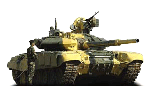
What are the activities of your department?The Directorate General of Information Systems at Army Headquarters handles the development and fielding of Operational Information Systems (OIS) and Management Information Systems (MIS), proliferation of Information Technology, Military Survey and cartography and the utilization of space assets for the Army. This encompasses a wide spectrum of activities ranging from identifying automation needs, conducting systems studies, interacting with development agencies, monitoring and providing impetus to the spread of IT in the Army and catering to the IT training needs of the Army. Providing hardware and application software to an organization as large as the Indian Army also falls within its charter. Insofar as Military Survey is concerned, the Directorate is responsible for rendering technical advice to Ministry of Defence on survey matters, maintenance of digital cartographic and topographic data of our areas of responsibility (along and across the international borders), supplying maps to the Armed Forces and coordinating policies on mapping with the Survey of India. How important are geoinformation technologies?All systems dealing with battlefield management strive to achieve thehighest possible degree of shared situational awareness in the given time and space. Geo-information technologies (GIT) play a crucial role in contributing to this, whether it is in analysis of terrain or in assisting exchange of positional information between the various elements operating in the combat zone. It would not be wrong to say that Geographical Information Systems (GIS) are a crucial core component over which other applications for battlefield management systems are based.
How challenging was the adoption of new technology?Adopting new technologies is as challenging for us as it is for anybody else similarly placed. However, since we deal with the all-important aspect of battlefield management systems, the issues involved are slightly more complex. Our approach can basically be defined as being open to adopting new technologies and yet retaining the flexibility to continue using existing legacy systems and equipment till they are replaced. Thus, major challenge arises in, both, the integration of new and old as well as changing over to new systems. New technologies not only necessitate organizational adaptation and changes in training methodology but, in certain cases, also require review of existing practices, procedures and doctrines in addition to re-structuring of existing organization in some cases. We are justifiably proud of the fact that the Indian Army has a well proven ability to adapt to new weapons and equipment as well as emerging technologies with practiced ease. This will stand us in good stead as we transit to a new era of warfare dominated by the need to achieve information superiority. How do you see the growth of GIT in India?The growth of geo-information technology in our country will surely be an extension to the growth in rest of the IT sector. The benefits of this technology need to be exploited for various development programs that the Government is already taking in this direction. Growing aspirations are bound to lead to better geospatial data and suitable applications to exploit that data. The growing demand in the infrastructure development sector, and for a number of other uses such as disaster management, will definitely spur our industry to invest more in research and development activity in this field leading to reduction in our dependence on expensive foreign commercial applications. What are the challenges you are facing in the field of GIS?Exchange of geospatial information between different GIS applications remains the biggest challenge in relation to development of battlefield management systems. While the approaches suggested through the utilization of Open GIS Consortium (OGC), such as Geographic Markup Language (GML), are suitable for business enterprises to a large extent, they have major limitations in the context of utilization by armed forces. This is primarily on account of accuracy, which is paramount as also bandwidth availability and computing powers which tend to be restricted at lower levels in a hierarchical organization. Towards this end, we are actively pursuing the development of an indigenous GIS solution which can meet the requirements of a variety of users in the three Services and yet work on a common file format. The other challenge has been in terms of a common geographic reference framework for the three Services in terms of datum and projection. How far we can depend upon US controlled GPS?Over the last decade, the NAVSTAR system (or the GPS) has become an international navigation aid used by the US, its allies and others. Shutting down the system or selectively denying its use can have political implications and, as such, appears to be an unlikely proposition. Moreover, with the GLONASS becoming operational and the Galileo programme being in advanced stages of development, the US will not be the only one to have satellite based navigational systems. Our Government is also actively engaged in global efforts in this field, with ISRO actively involved with both the projects, and we do not foresee any situation which will bind us to any one constellation of satellites in the future. Going by recent statements in the press, it appears that ISRO is also considering a regional system using a constellation of geo-stationary satellites for India. This would further augment the facilities provided by existing systems. Google Earth poses a security challenge. Comments.Google Earth uses high resolution commercially available satellite imagery. No country can prevent its adversaries from obtaining these images from companies such as Space Imaging. Major international terrorist organizations have enough financial backing and resources to procure such data from commercial vendors of imagery. Therefore, whilst the imagery available on Google Earth do have some security implications, its geo-information technologies are being exploited by the community for interaction and assistance at people-to-people level in a world connected through the Internet. Should India insist on censorship as China has?As is well known, the Internet is not owned by any one country and the world community would not appreciate any censorship on it. The services provided by Google have to be seen in the context of other web casts and web logs on other electronic media portals. Many media publications voice their views on policies of the Government on TV, newspapers and their websites in our country. This has not resulted in the Government of India imposing censorship on them. China has a different political system as well as the means to control and monitor the Internet. It may be able to impose such a restriction within their territory, but have no jurisdiction on the free flow of information on the Internet. Lt Gen Ranjit Singh has observed that “Security concerns about maps are at times overplayed” (Coordinates Jan 2006). Comment.I am not aware of the exact context in which the statement was made and, hence, can not comment on it. Maps and other forms of geospatial data are crucial to the process of nation building and development. The 2004 Tsunami, the Oct 2005 earthquake in India and Pakistan, as well as Hurricane Katrina in USA have demonstrated that government agencies alone cannot single-handedly handle relief measures during disasters of such magnitude. Nations will have to rely on other agencies to assist in these measures. Unless geospatial data is available to them, and others willing to help, we will not be able to develop safe infrastructure or coordinate effective rescue and relief operations during times of crisis. Moreover, maps of numerous types are required for development purposes. Nonetheless, those agencies which are mandated to look into the security implications relating to mapping are only fulfilling their responsibilities when they express concerns and reservations when commenting upon a more open regime. |
|||||||
|
|||||||
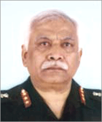 Lieutenant General Dilip N Desai, AVSM, VSM is the Director General Information Systems of the Indian Army since February 2005. In this assignment he guides and directs the efforts of the Indian Army in preparing for the emerging face of future battles that is network-centric warfare. Lt Gen Desai joined the National Defence Academy, Khadakwasla (Pune) in January 1963 and subsequently, was commissioned into the 18th


 (No Ratings Yet)


