Articles in the Perspective Category

I am not sure if new technologies like Google Earth are disruptive. People have often spoken about Google and Micorsoft being disruptive. It may be true in certain context.If you see the natural evolution the geospatial industry in last twenty years, I think that both have put many elements in a place in a form that has a widespread appeal. I think it has increased people’s awareness in geospatial information, certainly in the mass market. Actually, five or ten years before there was not much demand but with the involvement of big companies, much bigger footprints are now available. It surely has increased awareness.

AT the turn of the millennium there was a mood of optimism and then it all changed. The dot-com bubble burst, 9/11 occurred and climate change became an “uncomfortable truth”. In other words the spirit of the age, or Zeitgeist, changed and new challenges now face societies, industries and individual people.

In India, the “extra” digits in telephone numbers have been added a number of times e.g., the digits for Delhi have changed from 5 to 8 in the past five decades. However, with the addition of extra digit of “2” (or “3” or “5”) in the phone numbers of the cities around the countries in December 2002, the total number has reached to “10”, i.e., “2, 3, or 4” digits of city codes plus “8, 7, or 6” digits of phone numbers. In one colony of Delhi, since…

Traditionally GIS are considered to perform four basic functions on spatial data; input, storage, analysis and output. Of these, analysis has received least attention in commercial systems. Typically, a variety of map description and manipulation functions are defi ned by commercial vendors as being “Spatial analysis”, but they have little bearing on the use of this term in the Regional Science Community…

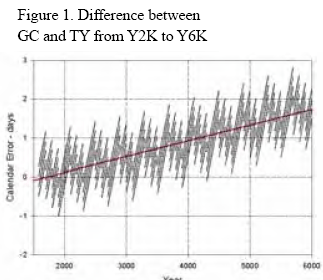
The Tropical or Mean Solar year consists of 365.24219879 mean solar days (dM) in which the Earth goes round the Sun. We use mean year and days as the actual year and days are not constant in their duration or they both fl uctuate. The length of the Tropical Year (TY) is measured by the time interval between successive appearances of the Sun in the vernal equinox.


 (5.00 out of 5)