Articles in the Navigation Category

MSAS (MTSAT Satellite-based Augmentation System is the Japanese satellite based augmentation system which has been prepared by the Civil Aviation Bureau of Ministry of Land, Infrastructure, Transport and Tourism (MILT) and started on 27 September 2007, to serve for improving accuracy, integrity, and availability of GPS positioning on the civil aircrafts. It has two geostationary satellites, called MTSAT-1R and MTSAT-2 located at 140 and 145 degrees in the east longitude, on the orbit of 3600km above the Equator. The satellites were launched in February of 2005 and 2006 respectively, long after the launch failure on November 1999. MTSAT, which stands for Multi-functional Transport SATellite, also has a function of geostationary metrological satellite.
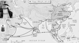
Zheng He’s Exploration of the Western Pacific Ocean and the Indian Ocean was an important event at the turning point of the world history. It was a golden opportunity for China to strengthen itself and make greater contributions to human beings. Unfortunately, to some extend, Zheng He’s magnificent feat in the history of navigation was later considered as a sheer waste of energy and money and a “failure policy”, and thus was put an end to. Zheng He’s trip, therefore, did not produce long-term effects. China still cut off itself from the out side world and stopped her exploration of ocean navigation, while Europeans, along the routes opened up by their expeditions, reached America, Africa and Asia and established colonies all over the world, which greatly promoted the capitalist development. In spite that the scale of Zheng He’s navigation far exceeded that of Columbus’s “Great Discovery” which followed some 80 years afterward, the former had much less effect on the progress of the world history.
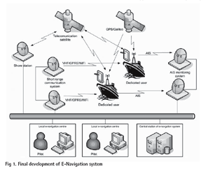
The common objective shared by all the Member States of IMO (International Maritime Organization) is a commitment to deliver safe, secure and effi cient shipping on clean oceans. The co-sponsors of this submission believe that IMO now has an opportunity to develop and map out a clear strategic vision for one common integrating and utilizing all the navigational technological tools at our disposal to secure a greater level of safety and incident prevention which will, at the same time, deliver substantial operating efficiencies with resulting commercial benefi ts, whilst also continuing to respect the freedom of navigation rights.

Fifteen years ago people hardly had mobile phones; today it seems awkward if you do not possess one. After this success story the IT sector has its new gadget: Navigation systems. Similar to the mobile phone market it is growing tremendously.
Market structure
That fierce competition has served well to bring prices down. So, nowadays most players are sourcing their products from sub-manufacturers in China. However, this means that anybody can enter the market and source easily navigation devices, when the volume commitment is big enough.
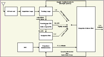
Global Navigation Satellite System (GNSS) consists of GPS, GLONASS and Galileo which is still under construction by the European Union. GPS is the most widespread GNSS in the world and applies successfully in so many fields such as positioning, navigation, geodesy, mapping, timing and so on. However, GLONASS has not done its work well for about ten years because of lack of funds. In summer of 2006, Russia’s GLONASS program continued its comeback and will have a full 24-satellite constellation by the end of 2009. Notably, China has a regional RDSS system using three geostationary satellites since 2000.
INS is a self-contained positioning and attitude device. In other words, it meets the all-environment requirement. The primary advantage of using INS is that velocity and position of the vehicle can be provided with abundant dynamic information and excellent short term performance. The main shortcoming is that the INS accuracy degrades greatly over time.
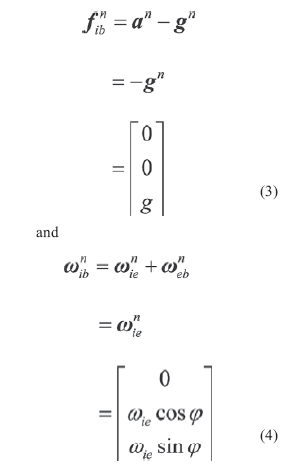
The object of the SINS selfalignment is to determine the direction cosine of the transformation from the body frame to the navigation frame, namely, the elements of initial attitude matrix, using the accelerometer and gyro outputs. As the alignment accuracy affects the accuracy of the navigation system directly, one of the most important requirements of SINS alignment is high alignment accuracy. In many practical applications, SINS alignment also requires high alignment speed and the capability of self-determination, especially for military applications.
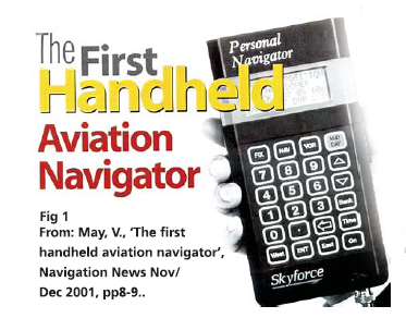
Today’s professional navigators may well be the last. As recently as a generation ago, navigation was almost solely the specialised art of a small number of highly-skilled people. They wore uniforms with emblems on their shoulders. They had years of training.They used complex, expensive, equipment. They bestrode the bridges of ships and the fl ight decks of the large commercial aircraft and took star shots.
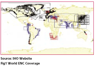
The Basic role of a Hydrographic Office’s (HO) is to provide essential hydrographic Services to support safe and efficient navigation and promote national maritime development for the nation. In recent years HOs all over the world are playing leading role in development of Electronic Navigational Charts for marine community so that vessels can navigate safely on their voyage across oceans.

This paper introduces the use of the map database as a sensor in driver assistance and awareness applications.Driver Assistance and awareness applications such as Adaptive Cruise
Control (ACC) and Forward Collision warning need to identify the
primary target in the host vehicle lane,which requires accurate estimation
of the geometry of the road between the host and the target vehicle.


 (5.00 out of 5)