| Mycoordinates | |
A strategic approach to data sharing
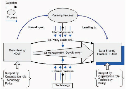
Investigation on existing practiceTable 1 represent MODELS that all stakeholders (company professional, * Model (No: 1) developed by two managerial and institutional aspects is based on Taxonomy of Spatial Data Sharing adapted from Calkins and Weatherbe 1995. Trade–off between existing and target practiceAn appropriate plan, data management and technology will affect the trade-off between existing and target practices. Each aspect of Geo–information use is to be compared alongside a corresponding guiding principle. Both planning process (internal) and Technology (external) pressure is against the guideline that is supported by GI-policy. If any aspect of Geo-Information use is not in line with the guideline, future investigations need to be made. (Figure 3) Planning process (internal pressure)Collection and maintenance The aim is to keep a record of what data is needed to perform a certain task, and where it is being sent to. Because of the Geo-Information value, the planning process needs to find what data is required? Where that data might be sent? And an event history to record what happens with that data? Update, standards and metadata Planning process needs to define standards by adding metadata element to meet up-to-date data. Data can be confusing or misleading if you don’t know who, what, why, when, where, and how it was created.[2] Real-time data availability If the data and the relevant Geo-Information is recorded to the specific Figure 3: sharing in transition (model adapted from Brian wilson – system thinking 2006) system of NOPP/or RPPP centre, it will be very easy to track and trace the progress of inter-organizational interaction without recollecting data. It can reduce the loss of data in data sharing and speed up data analysis. Technology (external pressure)The current status of technology offers many opportunities. From the Geo- Information management point of view, the planning process will use information technology to collect information very quickly. This will include the following components. Optimum technology Technology is articulated by hardware, software, operating system and communication protocol. How to store the required information? How to access and prepare access routines? Obviously information technology has become an important aspect in developing countries to achieve economic progress and the relative success in this area [3]. With growing data sets and more complex maps, data upload speeds can limit the use of the system [4]. Therefore, a user friendly information technology should be chosen. Dataset framework Framework data and information comprising themes that are continually needed and used by managers is another critical requirement. According to Frank 1992, [5] an organization contemplating sharing of spatial data needs to carefully define spatial objects, attributes, and data quality associated with these objects.[1] * Acquired data is used as a backdrop |


 (No Ratings Yet)


