| GIS | |
A Large-scale Monitoring System of Tree Tilt Angle through Integrating Smart Sensing Technology and GIS
A GIS-based platform of long-term monitoring the tilting angles of trees will be launched to identify potential tree root hazards |
 |
|
 |
|
 |
|
 |
|
Urban forests refer to the sum of all urban trees, shrubs and lawns and pervious soils in urban areas (Escobedo et al., 2011). Unlike trees growing in natural forests, urban trees are more prone to failure due to insufficient growing space, poor soil and bad or lack of maintenance. On the other hand, the increasing frequency of rainstorms and typhoons due to global climate change is another important threat to urban trees. Some tree species are more vulnerable to extreme weather and may be more affected (Johnston, 2009). Over the past decades, Hong Kong had experienced extreme weather conditions such as 4.2 days of extreme rainfall and an annual maximum 3-day rainfall of 367 mm (Hong Kong Observatory, 2018).
These rainfall conditions would increase to 5.0 days and 476 mm respectively between 2051 and 2060 under the high greenhouse gas emission scenario (Hong Kong Observatory, 2018). Urban forests, especially urban trees, provide important ecosystem services to city inhabitants. Urban trees play an important role in air pollution removal (Jim and Chen, 2008; Nowak et al., 2006); carbon sequestration (McHale et al., 2007); mitigation of heat island effect (Scholz et al., 2018); urban flood prevention (Cariñanos et al., 2018); water quality improvement (Nagabhatla et al., 2018); aesthetic enhancement (Price, 2003); biodiversity enhancement (Endreny, 2018) and conservation (Snep et al., 2011). With the ever-increasing urbanisation worldwide, the planning and management of urban forests and trees have become a key adaptation and mitigation measure of global climate change (Cariñanos et al., 2018).
Trees behave as a vibrant system. A tree’s anchorage is its ability to hold soil firmly with its roots to support the tree trunk and foliage. Weak anchorage can be reflected by the tilting of a tree, which in serious cases pose the hazard of falling. The weaving interaction between wind and trees is dynamic and depends on the degree of wind loading and natural frequency of trees i.e. the inherent vibrating frequency of tree (Moore et al., 2005). Wind force on tree canopy generates a turning momentum at the tree base. Such a turning momentum is resisted by the root system which determines the anchorage strength of a tree, and it can be considered as a function of the rotational angle of the structural root zone. If the root system i.e. anchorage strength is not strong enough to sustain the turning momentum, then the tree will tilt or even be uprooted and fall (Moore and Maguire, 2005). As such, measuring and monitoring urban trees’ root stability could help to predict more accurately tree fall risk and ensure public safety.
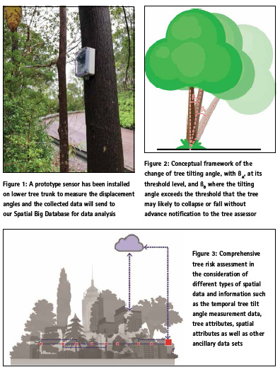
Many studies have been conducted to measure tree displacement via a wide spectrum of quantifiable tools, which includes accelerometers, displacement transducers, prism-based systems, tilt sensors or inclinometers, strain sensors and video-based techniques (James et al., 2013). These instruments help measure the rotational angle, tree displacement or tilting angle due to the overturning momentum of a tree. Whilst the use of the accelerometer for measuring tree tilt is not new, the increased capability of tilt accuracy, sampling frequency and battery life of measuring root-plate tilting angle has been enhanced and improved with the aid of state-of-the art technologies. The sensor can measure the mechanical response of the tree to wind force, recording the tilting values at near ground level and provides an insightful strength of root anchorage (TreeSensors, 2018). It is also important to study the failure pattern of different tree species on their root responses towards adverse weather conditions. In addition, monitoring root plates rotation on a regular basis would enable an early warning system in tree management to reduce the risk of damage caused by root failure.
In this study, we are developing an integrated tree tilting monitoring system based on Smart Sensing Technology (SST) – the technology of monitoring environmental changes with the use of remote sensors and techniques through the application of the Geographic Information Systems (GIS). Commenced in February 2018, the 3-year pilot Project is supported by The Hong Kong Jockey Club Charities Trust with a funding of $32.28 million. With tailor-made sensors installed on the lower trunk of approximately 400 selected urban trees in two pilot sites with high traffic and pedestrian flow: Kowloon East and Wan Chai, it aims to monitor their tilting angles over time using SST. The trees from 9 vulnerable species at risk of tree failure with different tree forms are selected for monitoring, e.g. Bauhinia variegata, Delonix regia, Senna siamea, Aleurites moluccana.
Taking various environmental factors into consideration, a threshold will be determined by the project team to measure the root-plate movement. If a sensor shows that the tilting angle of a tree exceeds the threshold, the system will alert the project team to conduct a visit and verify the data and calibrate the system. When deemed necessary, the relevant tree management team will be informed to conduct detailed investigations in a timely manner. In the second phase, SST sensors will be installed at over 8,000 trees across the entire city in Hong Kong. The Project will also collect data from the sensors and will develop a system via a GIS-based platform.
Big Data Analytics
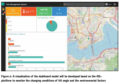
Results from thresholds and testing will be fed for Big Data Analytics for constructing a Spatial Big Database with interface of alert notification. This early monitoring system can help identify and mitigate tree failure efficiently and effectively by closely monitoring the alert thresholds observed from the selected trees in testing. A systematic early alert system with user interface will be developed as an analytical tool to evaluate the received tree movement data or threshold database in real time. The system can also be compatible with GIS platform for visualization and pinpointing the potential “follow-up” trees in testing. A compatible Android and iOS-platform will also be developed for effective management of urban tree species which are potentially vulnerable to climate change. GIS-based mapping and management tools have shown promise for effective maintenance and management of trees (Miller, 1997). Tree risk assessment analysis is also a pre-requisite for sustainable urban ecology. Analysis of the spatial distribution and properties of urban trees, site characteristics, and surrounding biotic and abiotic micro-environments, can help determine risk factors of urban trees.
There are various ways to estimate the extent of risk associated with urban trees. Since the tree risk assessment is comprehensive, requiring the use of different types of spatial data and information such as the temporal tree tilt angle measurement data, tree attributes (e.g., tree species, DBH, height, canopy shape, tree crown size, tree health status, and phenological stages), spatial attributes (e.g., proximities to highways, residential and commercial areas, topography, population density and buildings data) as well as other ancillary data sets (e.g., traffic, meteorological data and soil characteristics), as part of its assessment process. The GIS, a valuable tool, compared to conventional data processing systems, provides a means of handling and managing IoT and displays in the form of thematic maps (Marble et al., 1984; Foote and Lynch, 1996). In this project, a GIS-platform with a set of data analytic functions will be developed and useful for managing Spatial Big Data.
Aiming at sustaining a longer tree life by enhancing the efficiency of tree management, it is a Hong Kong’s largescale urban tree project using a quantifiable method to aid on conventional visual tree inspection method, supplementing information for the current industry practice. The GIS-based tree management system will provide an additional tool for the tree management team to provide scientific observations for monitoring changing conditions on tilt angles, which will facilitate tree monitoring in a massive scale based on their geographical locations of an individual tree. Findings from this study will also facilitate policy decisions to enhance tree management system in Hong Kong as well as other highly urbanized tropical cities.
Conclusion
A GIS-based platform of long-term monitoring the tilting angles of trees will be launched to identify potential tree root hazards. It is important to study the tree tilt pattern of these common tree species and preserve these trees especially under the threat of climate change. Trees can be monitored on a regular basis to observe tree tilting. As the adverse weather is predicted to be more frequent, large-scale monitoring system becomes an urgent need. The system will trigger a notification message from the SST sensor if a tree is tilted exceeding a threshold angle. In a nutshell, the monitoring system will be a spatially explicit GIS-based early notification framework of measuring and monitoring tree movement to transform uncontrollable forces of nature into timely manageable challenges in Hong Kong’s urban areas.
Acknowledgement
The project team wishes to acknowledge The Hong Kong Jockey Club Charities Trust, funding us to commence this Project for the enhancement of the tree monitoring system in Hong Kong.
References
Cariñanos, P., Calaza, P., Hiemstra, J., Pearlmutter, D. & Vilhar, U. (2018). The role of urban and peri-urban forests in reducing risks and managing disasters. Unasylva, 69, 53-58.
Endreny, T.A. (2018). Strategically growing the urban forest will improve our world. Nature Communication s, 9, 1160, 1-3.
Escobedo, F.J., Kroeger, T & Wagner, J.E. (2011). Urban forests and pollution mitigation: Analyzing ecosystem services and disservices. Environmental Pollution, 159, 2078-2087.
Foote, K. E., & Lynch, M. (1996). Geographic Information Systems as an Integrating Technology: Context, Concepts and Definition, TX: University of Texas.
Foster, D.R., Boose, E.R. (1995). Hurricane disturbance regimes in temperate and tropical forest ecosystems, in: Grace, J., Coutts, M.P. (Eds.), Wind and Trees. Cambridge University Press, Cambridge, pp. 305–339. doi:DOI: 10.1017/CBO9780511600425.019
Hong Kong Observatory (2018). Retrieved September 14, 2018, from URL: http://www.hko.gov.hk/climate_ change/proj_hk_rainfall_e.html
James, K., Hallam, C., & Spencer, C. (2013). Measuring tilt of tree structural root zones under static and wind loading. Agricultural and forest meteorology, 168, 160-167.
James, K. R., Haritos, N., & Ades, P. K. (2006). Mechanical stability of trees under dynamic loads. American journal of Botany, 93(10), 1522-1530.
Jim, C.Y. & Chen, W.Y. (2008). Assessing the ecosystem service of air pollutant removal by urban trees in Guangzhou (China). Journal of Environmental Management, 88, 665-676.
Johnston, M. (2009). Vulnerability of Canada’s tree species to climate change and management options for adaptation: An overview for policy makers and practitioners. Canadian Council of Forest Ministers.
Marble, D. F., Calkins, H. W., & Peuquet, D. J. (1984). Basic readings in geographic information systems. Williamsville, NY: SPAD systems.
McHale, M.R., McPherson, E.G. & Burke, I.C. (2007). The potential of urban tree plantings to be cost effective in carbon credit markets.
Urban Forestry and Urban Greening, 6, 49-60. Miller, R. W. (1997). Urban Forestry: Planning and Managing Urban Greenspaces (2nd. ed). NJ: Prentice Hall. (pp. 105-130).
Moore, J. R., Gardiner, B. A., Blackburn, G. R., Brickman, A., & Maguire, D. A. (2005). An inexpensive instrument to measure the dynamic response of standing trees to wind loading. Agricultural and forest meteorology, 132(1-2), 78-83.
Moore, J. R., & Maguire, D. A. (2005). Natural sway frequencies and damping ratios of trees: influence of crown structure. Trees, 19(4), 363-373.
Nagabhatla, N., Springgay, E. & Dudley, N. (2018). Forests as naturebased solutions for ensuring urban water security. Unasylva, 69, 43-52.
Nowak, D.J., Crane, D.E. & Stevens, J.C. (2006). Air pollution removal by urban trees and shrubs in the United States. Urban Forestry and Urban Greening, 4, 115-123.
Price, C. (2003). Quantifying the aesthetic benefits of urban forestry. Urban Forestry and Urban Greening, 1(3), 123-133.
Putz, F. E., Coley, P. D., Lu, K., Montalvo, A., & Aiello, A. (1983). Uprooting and snapping of trees: structural determinants and ecological consequences. Canadian Journal of Forest Research, 13(5), 1011-1020.
Schaetzl, R. J., Johnson, D. L., Burns, S. F., & Small, T. W. (1989). Tree uprooting: review of terminology, process, and environmental implications. Canadian Journal of Forest Research, 19(1), 1-11.
Scholz, T., Hof, A. & Schmitt, T. (2018). Cooling effects and regulating ecosystem services provided by urban trees—novel analysis approaches using urban tree cadastre data. Sustainability, 10, 712, 2-18.
Snep, R.P.H., WallisDeVries M.F. & Opdam P. (2011). Conservation where people work: a role for business districts and industrial areas in enhancing endangered butterfly populations? Landscape and Urban Planning, 103, 94-101.
TreeSensors (2018). Retreived September 14, 2018, from URL: http://www. treesensor.com/Sensors.aspx


 (1 votes, average: 3.00 out of 5)


Leave your response!