NEWSBRIEFS – REMOTE SENSING
Feb 2009 | Comments Off on NEWSBRIEFS – REMOTE SENSING
|
|
|
|
|
|
|
 |
|
|
MapMart unveils one-stop portal
IntraSearch Inc. unveiled a new interface on its MapMart online mapping portal where satellite imagery customers can search, preview and order high-resolution data from DigitalGlobe, GeoEye, SPOT and KOMPSAT. www.mapmart.com |
|
|
China to grant remote sensing satellite to Indonesia
The Chinese government will grant Indonesia a remote sensing satellite to help monitor and provide early detections on events taking place in the sea. www.antara.co.id
|
|
|
|
|
|
|
|
QCoherent releases free LiDAR viewer
QCoherent Software, announced the release of its free LiDAR viewer, LP Viewer. www.QCoherent.com. |
|
|
Singapore Ground Station as GeoEye- 1 satellite imagery regional affiliate
GeoEye, Inc. has signed a multi-year agreement with the National University of Singapore to allow the Centre for Remote Imaging, Sensing and Processing (CRISP) to collect and sell Earth imagery and related products from its GeoEye-1 satellite. www.geoeye.com |
|
|
|
|
|
NOAA names first woman to direct National Geodetic Survey
Juliana P. Blackwell has been named the new director of NOAA’s Offi ce of National Geodetic Survey where she will oversee NOAA’s responsibilities for the nation’s spatial reference system. www.noaa.gov |
|
|
|
|
|
New Japanese satellite to monitor global warming
The Japan Aerospace Exploration Agency confirmed that the Greenhouse Gases Observing Satellite “IBUKI” (GOSAT) is now ready for the initial functional verifi cation operation. The satellite is scheduled to be in orbit for 5 years and preliminary data is expected to be ready soon. UN climate offi cials are hoping to work out a new emission treaty by December 2009, but this satellite should help to monitor gases before and after any treaty is signed. www.jaxa.jp/index_e.html |
|
|
|
|
|
Japanese group asks Google to stop map service
A group of Japanese lawyers and professors has asked Google Inc to stop providing detailed street-level images of Japanese cities on the Internet, saying they violated privacy rights. Google’s Street View offers ground-level, 360- degree views of streets in 12 Japanese cities and is also offered for some 50 cities in the US and certain areas in Europe. Privacy concerns about this service have grown in Japanese media ofl ate. Similar concerns have been raised in other parts of the world, including the US and Europe. |
|
|
3DVU announces Web-to-Mobile 3D aerial photo navigation
3DVU, announced Way2Go, an online web-based navigation planner combined with free mobile viewer of 3D aerial photography with real landscape elevation. It will be available soon for over 200m mobile users with Symbian S60 devices providing geocoverage of the entire USA, UK and major Western Europe. www.3dvu.com |
|
|
CNES relies on ERDAS Enterprise Solutions
Recently, CNES presented the catalog for the International Charter’s imagery resources powered by ERDAS’ enterprise solutions. The International Charter gathers ten space agencies from all over the world, including USGS (USA), ESA (Europe), JAXA (Japan), CNSA (China) and ISRO (India). In case of natural or man-made disaster, a unified system enables acquisition of space data resources from all Charter members, providing emergency and rescue services with the accurate and up-to-date information on the impacted area. www.cnes.fr |
|
|
Pirates seen from Space
ImageSat International, Israel utilised EROS B satellite to receive a series of images with spatial resolution of up to 0.7m featuring the area offshore Somalia where vessels seized by pirates are clearly seen. It provided ScanEx RDC with satellite images showing villages and bases of pirates on the coast of Somalia, moorings of their speedboats and motorboats.http://www.scanex.com/ 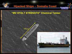 |
|
|
South African space agency to be established this year
South Africa shall have its own space agency later this year. According to the Department of Science and Technology, the agency would promote the peaceful use of outer space, foster research in astronomy, earth observation, communications, navigation and space physics, foster international cooperation in space-related activities, and advance scientifi c, engineering, and technological competencies through human capital development. http://www.dst.gov.za/ |
|
|
Beijing Earth Observation to distribute RapidEye products
RapidEye, announced that Beijing Earth Observation, Inc. (BEO), a subsidiary of Eastdawn Group. Inc., will be their Chinese distributor. www.rapideye.de |
|
|
|
|
|
|
|
|


 (No Ratings Yet)


