| Geodesy | |
The realization of geocentric datum for Brunei Darussalam 2009
Haji Mahadi bin Haji Mohamad Tahir, Haji Mohd Jamil bin Hj Mohd Ali, Kamaludin Omar, Khairul Anuar Abdullah, Dr Tajul Ariffin Musa, Rusli Othman
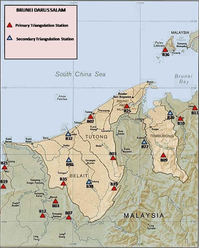
The Survey Department of Brunei Darussalam, with the collaboration of the Universiti Teknologi Malaysia (UTM), has carried out a study on the establishment of a new geodetic framework for the country. A new geocentric datum for Brunei Darussalam 2009 (GDBD2009) was established using GPS space geodetic technology based on the ITRF2005 reference frame. The GDBD2009 is related to ITRF2005 through the inclusion of the 8 GPS stations of the Brunei Darussalam Zero Order Network and have been processed together with more than fifty IGS stations around the world. The realization of GDBD2009 requires the determination of a new datum transformation and map projection scheme. A new set of transformation parameters to be use in converting from the existing local datum to the new GDBD2009 has been computed. The implication of this new datum on the existing cadastral and mapping practices, various GPS non-mapping applications, and the GIS/LIS related applications are taken into consideration. History of the Local Geodetic Reference System in BruneiThe initial survey of Brunei Darussalam was originally conducted in the period of 1934 to 1937 (Bridges, 1937), as part of the primary triangulation of British Borneo. In 1947, readjustment of this triangulation (including Sabah & Sarawak) was undertaken by the Directorate of Colonial Surveys to establish a local geodetic reference system known as Borneo Triangulation 1948 (BT48). This reference system had its origin at Bukit Timbalai and uses the Modified Everest as the reference ellipsoid. In 1968, the BT48 was further strengthen through a readjustment procedure consisting of the Borneo West Coast Triangulation of Brunei Darussalam and Sabah (1930-1942), Borneo East Coast Triangulation of Sarawak, the extension of the West Coast Triangulation of Sabah (1955-1960) and several Doppler points (1961-1968) (Majid et. al, 2003). The readjustment was performed based on Modified Everest as the reference ellipsoid, with the same origin and semi major axis of the ellipsoid as used in the BT48 solution. This local geodetic reference system was later known as the Borneo Triangulation 1968 (BT68). However, this BT68 datum was not being adopted in Brunei Darussalam (Abu, 1998). A Global Positioning System (GPS) network in Brunei Darussalam was established in 1992 using Wild Macrometers WM101GPS receivers and was then replaced with Wild System 200 receivers in 1994. A major GPS campaign covering Brunei Darussalam was undertaken in 1994 and 1995. During the period between 2002 and 2003, another GPS campaign was carried out on 17 stations which include some primary and secondary triangulation stations (see Figure 1) and new GPS monuments (Morgan, 2004). The main objectives of this campaign are (a) to establish a new GPS network, (b) to analyze the existing geodetic network and, (c) to obtain transformation parameters between WGS84 and BT48.
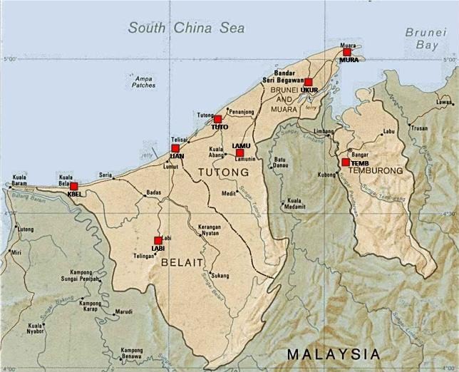
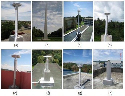
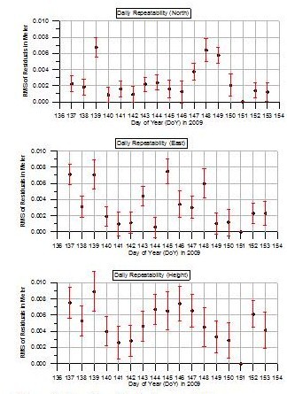
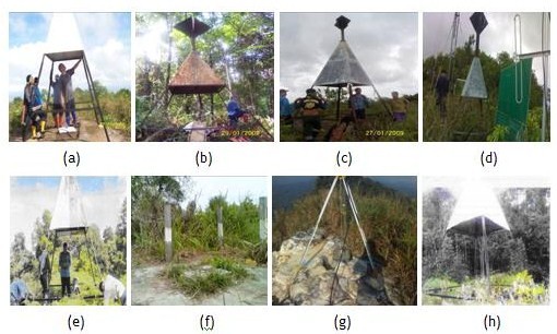
The Need of a Geocentric DatumIn the era of satellite-based positioning, where points anywhere on or near the Earth are determined in a continuous basis with the use of Global Navigation Satellite System (GNSS), in particular the Global Positioning System (GPS), the application of this space-based technique is preferred. Brunei Darussalam requires a coordinate system compatible with GPS in order to support high-precision positioning system, national mapping and navigation applications. These requirements cannot be effectively met by the existing BT48 datum. The adoption of a geocentric datum will support various geo-economics activities in Brunei Darussalam, being a nation that benefits from extensive oil and gas resources, as well as from the agriculture, forestry, tourist and banking sectors. Moreover, the implementation of the geocentric datum will provide an efficient exchange of spatial data between many data themes and to ensure that an integrated national geographic data infrastructure can be realized. ADOPTION OF ITRF2005 IN BRUNEI DARUSSALAMCurrently, there are eight (8) GNSS Continuously Operating Reference Station (CORS) included in the Brunei Darussalam Zero Order Network (see Figure 2). Each CORS is equipped with a GPS receiver, antenna, and electrical power supply and communication link providing 24 hours Real-Time Kinematic (RTK) data to GNSS/GPS users in Brunei Darussalam. The physical structure of these stations is shown in Figure 3. Figure 3: The Eight (8) GNSS CORS that form the Zero Order Network of Brunei Darussalam: (a) KBEL (b) LABI (c) MURA (d) LAMU (e) LIAN (f) TEMB (g) TUTO and (h) UKUR. The approach is to establish GPS baselines between Brunei’s CORS and the global network of GNSS stations of International GNSS Services (IGS). For this purpose, GPS data from Brunei’s CORS observed between 17th May 2009 and 2nd June 2009 were processed together with more than fifty IGS stations around the world. The Bernese multi-GNSS analysis software 5.0 (Dach et. al, 2009) was used for the data processing. Minimally constraints adjustment using free network solution was performed to adjust the daily solution. This process allows for the internal reliability test and outliers detection. Figures 4 depicts the combined daily repeatability of 3-dimensional stations coordinates for the Brunei’s CORS. RMS of residuals is between 2.78 to 3.73mm, 3.50 to 6.27mm and 4.89 to 10.15mm for northing, easting and height components respectively. These results indicate the internal accuracy of the Brunei’s CORS from the free network adjustment is between 2 to 7mm and 4 to 10mm for the horizontal and vertical components, respectively. Figure 4: Combined Daily Repeatability The Helmert 3D transformation was used for the Brunei ITRF realization using the previous results of the free network adjustment and the known IGS station coordinates. The realization of ITRF was fixed at 25 May 2009 (about mid-year) or 2009.45. It was found that the range of coordinate residuals is between 7 to 12 mm and 11 to 16 mm for horizontal and vertical, respectively. The RMS of fitting is 5.6 mm, 5.1 mm and 6.3 mm for the northing, easting and height components respectively. DETERMINATION OF BRUNEI DATUM TRANSFORMATIONOnce the adoption of ITRF2005 has been completed, the next task is to define the relationship between the local geodetic system BT48 and the newly established geocentric datum of Brunei Darussalam 2009 (GDBD2009). For this reason, the old primary and secondary triangulations of BT48 stations (see Figure 1) need to be revisited. These triangulation stations are to be observed using GPS technique in order to tie with the GDBD2009 reference frame. The most challenging task was to arrange an expedition to visit all of these stations (except for station B09, see Figure 1) since they were remotely located on the mountainous area in the Borneo tropical rain forest. A GPS campaign was conducted in January and March 2009. Snapshot of the location of these triangulation stations are given in Figure 5.
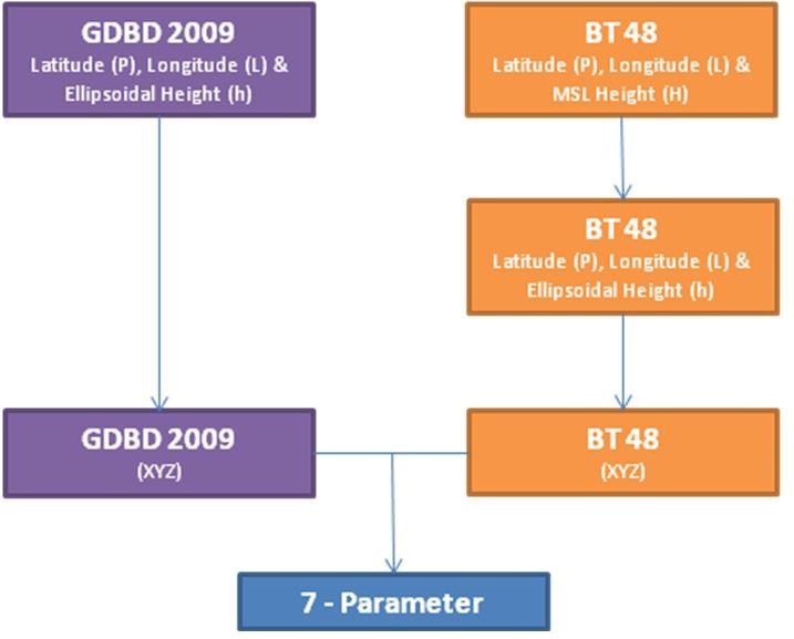
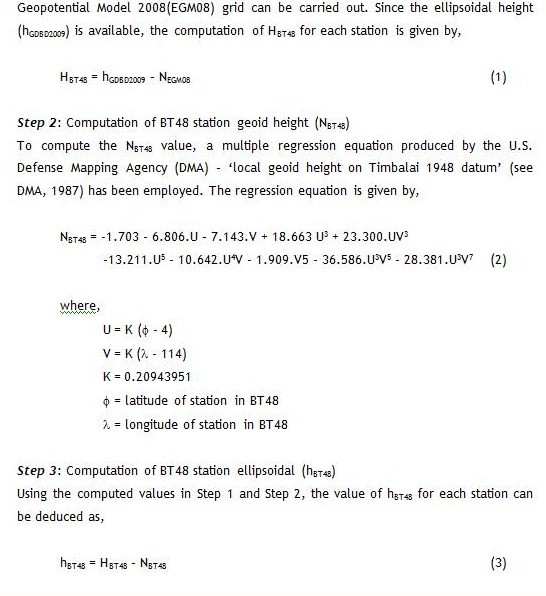
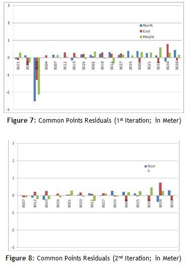
During the GPS campaign, data was collected over 48 hours duration at each station. The GPS data was processed using similar procedures as discussed in Section 2.0. The only difference is that the station coordinates of Brunei’s CORS in GDBD2009 reference frame were held fixed. Result from this network adjustment has shown that the RMS fitting is between 0.5 to 4mm and 2-10mm for the horizontal and vertical, respectively. The next step is to adopt the Bursa-Wolf model to derive a single set of seven transformation parameters between the GDBD2009 and BT48 using coordinates of common points. Figure 6 shows the derivation flow of this transformation procedure. Basically, the transformation procedure requires an ellipsoidal height from each station, and this creates a problem since there are only a few stations of BT48 with the height information. In addition, the existing height values are provided in ‘Mean-Sea’ Level (MSL), which probably was updated by the local authority using a local vertical datum. Figure 6: The Bursa-Wolf 7 Parameters Transformation Derivation Flow. To overcome the above problem, a ‘reverse’ height computation strategy was implemented. There are three (3) computation steps involve in this strategy, which can be summarized as follow: Step 1: Computation of homogenous BT48 station orthometric height (HBT48) As the common point’s coordinates are available in the GDBD2009 reference frame, the derivation of the geoid height (NEGM08) of each station from the global Earth
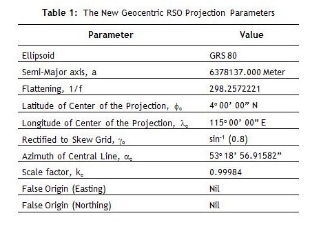
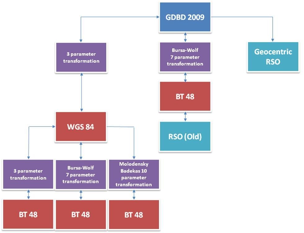
A new set of transformation parameters from GDBD2009 to BT48 consisting of shift component (Dx, Dy, Dz), rotation (Rx, Ry, Rz) and scale is given in the Technical Manual of GDBD2009 (SDBD, 2009) available at Brunei Survey Department. THE BRUNEI GEOCENTRIC RSO PROJECTIONFor many years, Brunei Darussalam has been using the Borneo Rectified Skew Orthomorphic (RSO) projection for the country rectangular coordinates system to serve the national cadastral and topographic mapping. The RSO projection is in many ways equivalent to Hotine Oblique Mercator (HOM) (Hotine, 1947; Snyder, 1987), which conformally maps an ellipsoid onto an oblique cylindrical projection with a line of constant scales skewed at an angle to the meridian; except that the defining parameters are different. These parameters are latitude, longitude and scale factor of the center of the projection, azimuth of the central line, skew azimuth, false northing and easting. Since the GDBD2009 has been realized in Brunei Darussalam with GRS80 as the reference ellipsoid, the RSO projection parameters related to this reference ellipsoid need to be redefined. Accordingly, the new geocentric RSO projection parameters for Brunei Darussalam are listed in Table 1. IMPLICATIONSThe newly established GDBD2009 may bring some implications to issues relating to GPS positioning, cadastral surveying and topographic mapping, navigation applications in land, maritime and aviation, and socio-economy. 1. The widespread use of GPS has further highlighted the need to adopt a geocentric datum in this country. Position determination using various GPS techniques has been increasingly being practiced for various surveying related applications. The existing GPS network in Brunei Darussalam will certainly provide better control for GPS positioning activities carried out by various mapping related agencies. Real time application of GPS positioning technology, especially in RTK GPS, will give an option for either real time or post-processing modes of positioning. Figure 9: Flow of Datum Transformation & Geocentric RSO Projection, and Relationship with GDBD2009. 2. The old RSO projection for cadastral mapping was based on the BT48 system referenced to the Modified Everest ellipsoid while the corresponding reference ellipsoid for the geocentric GDBD2009 is the GRS80. With the GDBD2009 datum, geodetic coordinates of a point determined using GPS by cadastral surveyor can now be projected directly to their related geocentric RSO plane coordinate values without converting first to BT48 system. Moreover, by reducing the step of the coordinate transformation will reduce any defect caused by imperfection in the value of the defining parameters being used. Figure 9 shows the flow chart that allows various coordinate systems to be converted from one system to another. The old RSO can be converted to BT48 and to GDBD2009 by using the Bursa-Wolf 7 parameter transformation and vice-versa. RSO projection is now viable between Geocentric RSO coordinates and GDBD2009 coordinates. Consequently, it allows the conversion between BT48 and WGS84 (using 3-parameter) and from WGS84 to BT48 (using Bursa-Wolf 7-parameter method or Molodensky-Badekas 10-parameter method) to be performed. 3. Application of satellite positioning technology in maritime navigation has been practiced by commercial ships and liners, the NAVY and port authorities. Intelligent Transportation System (ITS), which integrates GPS positioning technology, ICT and electronic technology, has been widely used in modern transportation system. For example, an autonomous ITS system requires the integration of GPS positioning equipments with electronics chart in a vessel enabling the system to give effective travel direction since its position is always shown on the chart. Other such applications are in the aviation and fleet management. GDBD2009 will provide better coordinate system infrastructure compatible with GPS positioning technology implemented for navigation applications. With GDBD2009, geodetic coordinates of a point determined in WGS84 using GPS could be directly projected to their related geocentric RSO plane coordinate values. This is an advantage that will spur the use of GPS for navigation applications in this country. 4. The adoption of GDBD2009 will accommodate the integration of spatial datasets and consequently, will provide better data sharing, handling and management. The GDBD2009 provides coordinates that are appropriate for applications at all levels (local and international) and allows the easy integration with other information technologies. By using the GDBD2009, it will minimize confusion for all users and provide maximum accuracy where high precision is required. CONCLUSIONSIn implementing GDBD2009, matters related to datum transformations and map projections have been considered. The new Geocentric Datum for Brunei Darussalam or GDBD2009 has been successfully established using the GPS technology, and by adopting the ITRF2005 at epoch 2009.45 and GRS80 as the reference ellipsoid. The GDBD2009 is connected to ITRF2005 by the inclusion of over fifty (50) International GNSS Service (IGS) sites in the precise baselines processing and network adjustment of GPS stations of the Brunei’s CORS. Accuracy estimate for the stations in the network that define GDBD2009 is found to be in the order of 0.5-4mm and 2-10mm for the horizontal and vertical components, respectively. With GDBD2009, geodetic coordinates of a point determined using GPS by a cadastral surveyor can now be projected directly to their related geocentric RSO plane coordinate values without converting first to BT48 system. A new set of geocentric RSO projection parameters for Brunei Darussalam has been defined. With the establishment of GDBD2009, data migration will become so imminent now and will definitely lead to all maps either large or small scale to be revised or reproduced. Future issues relating to height modernization in Brunei Darussalam will have to be addressed. Thus, a homogeneous height value for Brunei Darussalam can be implemented nation wide. The implementation of GDBD2009 will further encourage the use of GNSS/GPS positioning technology by various mapping related agencies in this country. Definitely, government department and non-government organization as well as the public will benefit in many ways from GDBD2009, the new geocentric datum of Brunei Darussalam. AcknowledgementReferencesAbu, S. H. (1998). Geodetic and GPS activities in Malaysia by the Department of Survey and Mapping, Malaysia. In Proceedings of Geoinformasi ’98, Kuala Lumpur, 7-8 September. Dach R., Hugentobler, U., Fridez, P. and Meindl, M. (2007). User Manual of Bernese GPS Software Version 5.0. Astronomical Institute, University of Bern, Stämpfli Publication AG, Bern, June 2008. DMA (1987). Department of Defense World Geodetic System 1984: its definition and relationship with local geodetic systems (2nd edition). Technical report no. 8350.2, Defense Mapping Agency, Washington. DSMM (2003). Technical Manual of the GDM2000. Department of Survey and Mapping Malaysia Hotine, M. (1947). The Orthomorphic Projection of the Spheroid. Empire Survey Review, No.64, Vol. 9. Kadir, M., Ses, S., Omar, K., Desa, G., Omar, A.H., Taib, K and Nordin, S. (2003). Geocentric Datum GDM2000 for Malaysia: Implementation and Implications. Seminar on GDM2000, Department of Survey & Mapping Malaysia, Kuala Lumpur, 28 August 2003. Morgan, P., Kasenda, A. and Kearsley, A. H. W. (2004). GPS Geodesy in Brunei Darussalam During 2002 And 2004. Brunei Darussalam Survey Department Technical Report. SDBD (2009). Technical Manual of the GDBD2009. Survey Department Brunei Darussalam, Version 1.0, 2009. Snyder, J. P. (1987). Map Projections – A Working Manual. US Geological Survey Professional, paper 1395, US Government Printing Office, Washington, DC.
|




 (5 votes, average: 3.00 out of 5)


Leave your response!