| Applications | |
Towards smart future cities: 3D cadastres as a fundamental enabler
It is essential that cadastral systems be linked with broader environmental information to support urban management |
 |
|
 |
|
The rise of the smart city
Urbanisation is one of our most significant challenges (Suzuki et al, 2010). Rightly or wrongly, achieving sustainable urbanisation has been increasing reliant on high-rise, high-density buildings as the dominant urban form, and the stratified use of space to provide infrastructure, utilities and services both above and underground.
High-rise buildings, which have traditionally been used for commercial purposes, are now becoming a key urban response for housing in both developed and less developed countries, and is one that is endorsed both pedagogically and politically (e.g. Turkington et al, 2004; McConnell and Wiley, 2010; Yeh and Yuen, 2011; Rowley and Phibbs, 2012; Jackson, 2012). This drives a need for robust information about land and property rights, restrictions and responsibilities (RRRs), about which the cadastre has always had a fundamental role.
Residential developments also arguably drive an accompanying need for investment in infrastructure and services such as laying utilities (e.g. fibre optic networks), underground cities, large shopping complexes, subterranean rail systems. As spatial entities, these developments impact on the urban form with corollary impacts on urban flows (e.g. energy, travel, etc) and functions (e.g. land use) (Salat and Bourdic, 2012). We therefore need information about all aspects of the built form to facilitate better decision-making to support the functioning of our cities. In addition, the growing adoption of urban consolidation strategies around the world produces a range of other challenges associated with the increase in size and complexity of highrise apartment buildings. These include facilitating an inclusive, vibrant and liveable community environmental concerns, and complexity in economic, political and regulatory forces (e.g. (Randolph, 2006).
Against this backdrop, attitudes towards developing and managing buildings are also evolving. For example, IBM now champions a “brick, mortar, data” philosophy that seeks to leverage the digital economy and the proliferation of data about buildings that is a by-product of its development (IBM, 2012). Governments are recognising the need to harness the wealth of information relevant to buildings to facilitate design, construction and management aspects of buildings for sustainable development (National Science and Technology Council, 2008). Such attitudes are encapsulated in the ‘smart city’ movement, a concept that has evolved from the notion of the ‘intelligent city’ (Allwinkle and Cruickshank, 2011).
Smart cities, have often been perceived to reflect cities that have become successful in using information and communication technologies – particularly those that help citizens connect – in aspects of city management and administration (Allwinkle and Cruickshank, 2011). However, there has been a more recent recognition that smart cities have emerged to respond to the specific challenges facing a city, and to do so by using ICT to connect people with place and data, thereby harnessing both social and physical capital to build intellectual capital and support participatory practices in governance of a city’s resources (Hollands, 2008; Caragliu et al, 2011). This relationship between people, place and data, infers a fundamental role for 3D digital cadastres in any smart city movement.
Underpinning smart future cities: 3D Cadastres
Supporting the development of smart future cities will be a key strategy for urban sustainability, and the ability to plan for this will be incumbent on governments’ ability to leverage the masses of data and information now available about many aspects of the built environment. Multi-dimensional data and information are becoming increasingly available, such as 3D land and property ownership information and land use census data, which have the potential to underpin better planning for healthy, liveable and productive cities. In particular, as the land administration industry has come to realise that there is a pressing need to better understand the vertical properties of our cities – yet most analyses of cities continue to be undertaken using aggregate boundaries and in 2D space.
Developments in 3D Digital Cadastres
Many of the statutory systems that currently administer accurate land administration information, including core cadastral systems (representing ownership boundaries), are legacies of a longstanding 2D-based paradigm in recording and representing land and property information. As the yield of information and data from complex urban environments grows exponentially, it is becoming evident that this 2D paradigm is of limited utility, and there is clear demand for more efficient approaches to information management and analysis for decision-making. This is essential to achieving sustainable planning outcomes and ongoing management of our cities.
With the maturation and accessibility of 3D technologies, there is now both opportunity and demand to embrace a 3D digital environment for land administration business practices. Significant progress has been made in advancing the concept of 3D digital cadastres, leveraging an object oriented approach to managing information about land and property rights, restrictions and responsibilities (RRRs). Research and development, often in collaboration with industry, is currently being undertaken in almost 30 different countries. This has culminated in several international workshops – most of which has only taken place over the last four years (under the stewardship of the International Federation of Surveyors), a telling indicator that a solution is being urgently sought. Research outcomes are gaining momentum: we have recently seen the endorsement of the Land Administration Domain Model as an ISO standard; there are now a number of jurisdictions developing prototype systems, and the number undertaking pilot trials are also significant (e.g. Russia, China, the Netherlands, Indonesia, Australia and Malaysia).
Other 3D Land and Property Models
The move towards 3D cadastres is occurring alongside significant momentum in the land development industry on producing and using 3D-enabled building information, evident in the successful international diffusion of Building Information Models (BIM).
There are numerous definitions as to what constitutes BIM, but it is essentially recognised as a an information model, i.e. a product, where information about all the elements of a building are visualised as a 3D model, which is underpinned by a collaborative process for producing building information to serve as a unified repository of information about all components of the building that is accessible to stakeholders (e.g. NBIMS-US, 2014; Eastman et al, 2011; Smith et al, 2012). BIM as both product and process innovation has delivered significant improvements in productivity across the land development industry, primarily in planning, coordinating and analysing building design across multiple stakeholders. The value in integrating building design information generated by multiple stakeholders in the development process lies in reducing the costs of design changes and improving project documentation. In modern developments where there can be up to 18 different stakeholders (Rahman, 2010), these costs have been estimated to be account for up to 30 percent of the total costs per project (Brown, 2008).
Associated with BIM is the concept of Precinct Information Modelling/Models (PIM), which extends the capabilities of BIM to the precinct level (Plume, 2013). This opens up new opportunities to evidence-based planning and precinct assessment. Currently, work on this area within Australia is occurring through a number of research groups and builds on research that uses IFC to store and represent cadastral boundary information.
Moving Towards Integrated Land and Property Systems
Given the increasingly complex (structural, social and administrative) attributes of our cities, there is a need for integrated land and property systems for evidence-based planning and decisionmaking. An integrated and collaborative approach to planning and management of our urban environment can result in reduced environmental impact through conservation of resources and lower emissions such as those being witnessed in places such as Stockholm (Gaffney et al, 2007), Singapore (Tortajada, 2006) and Curitiba (IPPUC, 2009).
Bringing together all the various and disparate sources of information about our built environment is therefore a sustainability imperative. However, efforts to harness the wealth of multi-dimensional information that is being generated, and will continue to be generated in the future through urban planning and land development processes, is being stymied by the current lack of capability in integrating existing statutory land administration systems (e.g. land registries) with the broader information environment. This integration is fundamental, as it will provide the element of accuracy to enable the delivery of an accurate and accessible integrated knowledge base necessary to support the multi-faceted decision-making: 3D cadastres can provide the accurate, authoritative and unambiguous foundation for understanding the urban form.
3D cadastres and smart future cities: Challenges and opportunities
Given the nature of the information held in land registries, there has always been recognition of the potential that cadastral systems have in supporting a broader range of environmental applications. This is evocative of previous discourses in the late 1970s around ‘multipurpose cadastres’ (e.g. McLaughlin, 1975), which arguably, is a notion that is still highly relevant today. More importantly in doing so, the connection of 3D cadastral information with the multiple information streams pertaining to the urban built environment preserves the relevancy and role of cadastral information as fundamental to all societies.
For this to occur, there is a need for the land administration industry to adopt a proactive approach to exploring solutions that extends beyond our traditional practicing paradigm to uncover the new connections that can be formed. For example, the use of BIM models has been growing exponentially – as much as 400 percent over the last five years in North America alone (McGraw-Hill, 2012); international trends also reflect a similar trajectory (Davis Langdon, 2012). BIM is no longer a disruptive phenomenon but represents a technological and an operational evolution that the land administration industry can ill afford to ignore. As national governments around the world begin to mandate the use of BIM, it certainly underscores the rationale of exploring BIM for cadastral purposes. This is also a sensible as it facilitates a bridge between land registries and cadastral organisations and the broader construction and management industries.
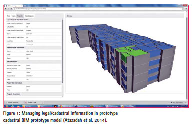
Preliminary investigations at our research centre demonstrates the potential of using BIM for managing and representing 3D cadastral information, in particular, this would give the user full control over building components and functions (Shojaei et al, 2014). Figure 1 show how the IFC data model was used to construct cadastral entities around ownership and easements. As an example, one legal property object is highlighted in green and associated legal information is represented in a window on screen.
It was also possible to provide the community and relevant stakeholders with a way to visualise the cadastral BIM prototype model online, where users could see the relationship between cadastral information and the physical built environment. Figure 2 shows the online environment where the visualisation application provided users with a range of controls for identifying, querying and visualising different parts and functions of the building.

There are many other opportunities that present potential areas of research for supporting the vision of smart future cities. Some of these lie at the nexus of traditional silos such as those between land development and land management; integrating statutory data (e.g. property values) and socially-derived information (e.g. social media volunteered geographic information); bringing together data from multiple environmentally-oriented industries. Additionally, there are those opportunities driven by future needs, demands and expectations such as disaster management and public safety, planning and decisionmaking to secure liveability and productivity of cities, and urban resilience. The commonality across these various themes is that they all require a spatially accurate map base and 3D cadastres as foundations.
It is essential that cadastral systems be linked with broader environmental information to support urban management. The ability to do so is of growing importance especially in our current digital milieu, where an unprecedented volume of data being produced in cities. In this environment, digital interoperability, particularly spatial digital interoperability, is fundamental and is being recognised as a key challenge and policy imperative by governments around the world (an example being the United Kingdom’s current public consultation on spatial digital standards). However, it is not only the role of government, but also the role of professional associations if there is to be a truly integrated approach to using 3D land and property information. While there is no doubt as to the increasing technological orientation of cadastres, it should not detract from the fundamental role that cadastres have in society, which continues to be central to facilitating the delivery of other national visions, digital economies, fundamental datasets and realising sustainable, resilient and smart cities of the future.
Acknowledgements
This article is based on research from an ongoing Australian Research Council Linkage Project (LP110200178), “Land and Property Information in 3D” being conducted at the Centre for SDIs and Land Administration at the University of Melbourne. More information about the project can be accessed from csdila.unimelb.edu.au/projects/3Dwebsite.
References
Allwinkle, S. and Cruickshank, P. (2011). Creating Smart-er Cities: An overview. Journal of Urban Technology, 18(2), 1-16.
Atazadeh, B., Kalantari, M., Rajabifard, A. and Ngo, T. Harnessing Building Information Modelling to administer properties in high-rise buildings. Building Information and Research. Under review.
Brown, K. (Ed.) (2008). BIM: Implications for government. CRC Construction Innovation, Commonwealth of Australia.
Caragliu, A., Del Bo, C., and Nijkamp, P. (2011). Smart Cities in Europe. Journal OfUrban Technology, 18(2), 65-82.
Davis Langdon (2012). The Blue Book: Accessible knowledge for the property and construction industry 2012. Davis Langdon Australia. Retrieved from http:// www.davislangdon.com.au/upload/ StaticFiles/AUSNZ%20Publications/ The%20Blue%20Book/Blue-Book- 2012-FINAL.pdf on 21 March 2013.
Eastman, C., Teicholz, P., Sacks, R. and Liston, K. (2011). BIM handbook: a guide to building information modeling for owners, managers, designers, engineers, and contractors (2nd ed.). Hoboken, NJ: John Wiley and Sons, Inc.
Gaffney, A., Huang, V., Maravilla, K. and Soubotin, N. (2007). Hammarby Sjostad Stockholm, Sweden: A case study. CP 249 Urban Design in Planning 2007. Retrieved from http://www.aeg7.com/assets/ publications/hammarby%20sjostad.pdf.
Hollands, R. (2008). Will the real Smart City stand up? Creative, progressive, or just Entrepreneurial? City, 12(3), 302–320.
IPPUC (Institute for Research and Urban Planning of Curitiba). (2009). The city of Curitiba: Planning for sustainability; an approach all cities can afford. Presentation at World Bank Energy Week 2009, World Bank, Washington, DC, March 31.
IBM (2012). Smarter Buildings. Retrieved on 27 February 2013 from https://www. ibm.com/smarterplanet/us/en/green_ buildings/overview/index.html?re=sph.
Jackson, C. (20 September 2014). Living the high life. The Wall Street Journal. Retrieved from http://www.wsj.com. McConnell, V. and Wiley, K. (2010). Infill Development: Perspectives and evidence from economics and planning. Discussion Paper for Resources of the Future. Retrieved on 6 October 2014 from http://www.rff.org/rff/ documents/RFF-DP-10-13.pdf.
McGraw Hill Construction (2012). The business value of BIM in North America: Multi-year trend analysis and user ratings (2007-2012), Smart Market Report. Retrieved on 13 August 2013 from http://bradleybim.files. wordpress.com/2012/12/2012_bim_ smartmarket_report_business_value_ of_bim_in_north_america.pdf.
McLaughlin J.D. (1975). The nature, function, and design concepts of multipurpose cadastres. Doctoral dissertation, University of Wisconsin Madison, USA. National BIM Standard – United States (NBIMS) (2014). National BIM Standard- United States™ (Version 2): An initiative of the National Institute of Building Sciences buildingSmart alliance™. Retrieved on 20 May 2014 from http:// www.nationalbimstandard.org/.
Plume, J. (2013). Precinct information models to facilitate low carbon built environments. Proceedings of bSI-BIM Week, Munich, Germany, October 2013.
Rahman, M. (2010). Complexity in building design. Proceedings of the 3rd International Holcim Forum for Sustainable Construction, “Re- Inventing Construction”. Mexico City, April 14-17 2010. Retrieved on 17 April 2013 from http://www. holcimfoundation.org/Portals/1/docs/ F10/ExpertPapers/F10_BlueWorkshop_ Paper_Rahman Mahadev.pdf.
Randolph, B. (2006). Delivering the compact city in Australia: current trends and future implications. Urban Policy and Research, 24(4), 473-490.
Rowley, S. and Phibbs, P. (2012). Delivering diverse and affordable housing on infill development sites. Australian Housing and Urban Research Institute Final Report No. 193. Retrieved from http://www.ahuri.edu.au.
Salat, S. and Bourdic, L. (2012). Urban complexity, efficiency and resilience. In Z. Moran (ed.), Energy efficiency – a bridge to low carbon economy (pp.25-44). InTech.
Shojaei, D., Rajabifard, A., Kalantari, M., Bishop, I. D. and Aien, A. (2014). Design and development of a web-based 3D cadastral visualisation prototype. International Journal of Digital Earth. DOI: 10.1080/17538947.2014.902512.
Smith, D. K. and Tardif, M. (2012). Building Information Modeling: A strategic implementation guide for architects, engineers, constructors, and real estate asset managers [electronic resource]. Chichester: John Wiley & Sons. Tortajada, C. (2006). Singapore: An exemplary case for urban water management. Additional Paper, Human Development Report, United Nations Development Programme, New York.
Turkington, R., van Kempen, R. and Wassenberg, F. (Eds.) (2004). High-rise housing in Europe: Current trends and future prospects.
Delft: Delft University Press. Suzuki, H., Dastur, A., Moffatt, S., Yabuki, N. and Maruyama, H. (2010). Eco2 Cities: Ecological cities as economic cities. Retrieved from www.worldbank.org/eco2.
Yeh, A. and Yuen, B. (Eds.) (2011). High-rise living in Asian cities. London: Springer.


 (180 votes, average: 1.09 out of 5)


Leave your response!