| SDI | |
Spatial Data Infrastructure in the Sultanate of Oman
This article attempts to fill in the gaps in the Sultanate of Oman’s National Spatial Data Infrastructure initiative project |
 |
|
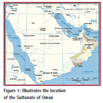
The Sultanate of Oman is located in the South-East of the Arabian Peninsula along the latitude (16°40´ and 26° 20´) North, and longitude (51° 50´ and 59°40´) East. It overlooks the Gulf outlet (Hurmuz Straight) in the North, Arab Sea on the East, with an estimated area of 309.500 square meter with a border line that stretches for 1,374 km shared with the Republic of Yemen to the South and South West, Kingdom of Saudi Arabia to the West and the UAE to the North West.
During the lapsed period of the 43 years of Oman’s renaissance, a very rooted progress and wide development in the country’s infrastructure occurred. This has great influence in lifting up and raising the level of living, and the oil sector played a prominent role in supporting and widening this development. The Sultanate took a great leap forward to support this sustainable development, and enlarge and develop the infrastructure in all fields and improve economic opportunities.
This wide construction development, which the Sultanate witnessed, was associated with imbalance in land usages, as the development was greatly focussed on some urban areas of great residential concentration, hence, causing a lot of problems in planning and construction expansion. As a result, it was a challenge for the country to deliver all its services to the entire region of the Sultanate, due to the varied geographic distribution between mountains, hills and deserts. Accordingly, the Sultanate has targeted itself to the importance of activating a national spatial strategy aiming at rectifying this path and finding clear visions, through which the country can develop remote rural areas to deliver the economic development effects and improve the various income resources in line with the sustainable development ambitions. Naturally, any strategic vision must be based on fully integrated information, where the idea of lifting the level of information that encourages participation and ideal use of spatial data as a starter to improve the government performance, disasters management, the strategic vision of raising the wheel of planning and construction to improve the various income resources as per well studied principles, has appeared.
This worldwide development witnessed by the technology of spatial data in operations such as (production, storage and use) has created a large sector of producers who deal with such data separately, where production process is done as per a solo vision, specifications and objectives. This has created financial and human burdens, waste of energy resources, and numerous problems such as data duplicity, weakness in participation and data integrity; not to mention the obstacles which have limited the achievement of common environment for the ideal usage of spatial data. Since spatial data represents the major components, which the development of economic, social and disaster management is based on due to its direct influence on planning and correct decision taking, the government orientations should be based on correct spatial data in order to achieve requirements of the different sectors. With clear and thorough view for the Sultanate geographic data, its diversification and the extent of meeting the demanding requirements of the Sultanate’s current development, this paper came to discuss the surrounding circumstances and its correspondence with the activation of the SDI and to what extent this current data would participate in the success of this initiative. The NSA’s role as a major player in the success of this orientation has also been reviewed.
Spatial Data
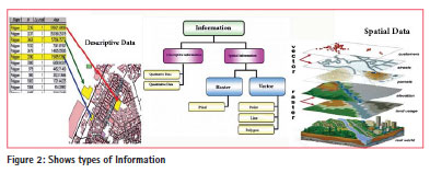
The spatial data is known as that information which must answer questions of location, shape, and relation of particles in space, and it describes the distribution of matters (natural or man-made) on the land surface. The characteristics of spatial data are differing in nature than that in its geometric shape. Simply, the data is the raw material which information is derived from, and it represents the base and solid database for GIS which allows users to derive useful information based on precise and correct data.
The spatial data is stored and coordinated in geographic databases. This requires full understanding of operations such as additions, administration, handling the information (integrity, retrieval and showcasing), analysis and production of other styles, representation, and abstracting/ producing information from the spatial data. Hence, such operations require special human skills, and special hardware and software. Data are represented in various forms – raster or vector symbols (points, line and area). Also, there is another type of data, the metadata which represents the spatial data’s features and characteristics, and are stored on configurations and alphabets table. Qualitative data is represented in the form of letters and words, such as names of locations. As for the quantitative data, this is represented in a form of digits as for population consensus and humidity percentage (see figure 2).
Spatial data Infrastructure – Initiative
One of the inevitable facts amid this information technology development is the ability of mankind to plan and deal with things that directly match with the information in hand. In the great nations, the information is owned and positively utilized for strategic planning, and this has formed a great quantitative leap towards supporting its economy and diversifying its income resources in many domains. The spatial data comes at the peak of the information pyramid with direct influence on decisionmakers, and planning as 80% of the information used by decision-makers are spatial data (Klinkenberg, 2013).
With great advancement in the use of spatial data, the need was tangent to create a suitable method to review the availability of spatial data and reduce the increasing cost of data production due to the increasing demands for such data. The necessity was a driving force to create new and precise data to be ideally used to meet the needs of the country’s establishments in a centralized form.
In early eighties, a what so-called (coownership under one umbrella) had emerged from within in every nation causing national geographic databases to be active and seek harmony with all levels in the country, starting from corporation level and then to local, national, regional and international levels. The Australian initiative in 1986 came as a starter for other nations to adopt this ideology, which began with the USA in 1987 and then the UK at the start of the ’90s. According to Crompvoets, J., and A. Bregt (2003).), the number of states sought to activate the spatial data infrastructure initiative until 2002 was 120 countries. The word infrastructure is used to promote the concept of supporting environment similar to a communications and roads network, whereas the word spatial data infrastructure is used to indicate access to and use of spatial data as per a common frame of agreements, practices and policies agreed upon for the ideal use of spatial data.
In line with the above, the expression ‘Spatial Data Infrastructure (SDI)’ is mostly used to point at the fundamental group of relevant, i.e., (technology, policies, arrangements and administrative matters) that facilitates availability and accessibility to spatial data. This forms a base to explore, evaluate the application of spatial data by users and producers at all levels. However, this entails us to say that, the SDI is more than a group of information or spatial databases. Actually, its concept extends to include features and characteristics of unified standards based data, user’s ways of reaching to this data and data application supporting services within an environment governed by organizational agreements that facilitate data management on various levels. Furthermore, the group of information is the common fundamental data group which everybody seeks to obtain, to enable them to produce new data derived or based on this spatial data.
SDI Definition
The purpose and definition of the SDI differs from one country to another depending on that country’s requirements and needs, as some countries at the time of adoption of this initiative, have focused on the production of data, or facilitate co-ownership or the use of standards. Therefore, there is no unified definition for the SDI initiative. The major definitions are:
a. Technologies, policies, standards and human resources necessary to acquire, process, store, distribute and improve utilization of geospatial data. (Executive Order of the White House 1994).
b. SDI as an umbrella of policies, standards and procedures under which organizations and technologies interact to foster more efficient use, management and production of geospatial data. (US FGDC, 2008).
c. ‘SDI is an initiative intended to create an environment in which all stakeholders can co-operate with each other and interact with technology, to better achieve their objectives at different political/administrative levels.’ (Chan et. al., 2001).
d. ‘The fundamental concept about facilitation and coordination of the exchange and sharing of spatial data between stakeholders from different jurisdictional levels in the spatial data community’. (Rajabifard Abbes, 2004).
The SDI Components
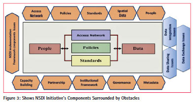
There is an active interaction between spatial data and the requirements of use by people through an existence of access medium to this produced data as per an agreed upon standards that achieve integrity between them. Hence, the initiative’s components include the group of data, people, policies, standards, and access network as a major element to activate co-operation between these vital components for the success operations of storing, distributing, data improving, maximum usefulness and achievement of integrity and co-ownership (Rajabifard & Williamson (2003).
The Executive Office of the President of the United States of America (2002) introduced 5 components for the American initiative, which included fundamental data, metadata, data clearance house, standards, and co-ownership. Whereas Kennedy’s initiative comprised 5 major components including technology, policy, frames, standards and accessibility (GeoConnections, 2008). In recent years, researchers have realized the role of influence of other components, such as capacity building, spatial data sharing, partnership and governance in the success and failure of spatial data initiative.
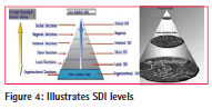
SDI Levels
The spatial data infrastructure is divided into many levels based on the functional level of this data and the extent of its services to different sectors. The precision and density of this data depends on the pyramid level shown in the figure (4). The data found in the organizational level is characterized by great density and large scale, which coincides with the company’s requirements in these operational stages, and it adversely lessens whenever we move to the upper level. As for data of the national level, it is determined according to partnership agreements between all establishments in service to their mutual interest, where data is upgraded to strategic planning operations and data management as well.
Spatial Data activities in the Sultanate of Oman
In the Sultanate, there are many organizations and agencies that produce spatial data and provide it to users, especially decision-makers. However, with the increasing demand for this data and the expansion of GIS applications in the Sultanate, the case of data production considered to be an obstacle which helped to create work duplicity, waste of the country’s resources and create more complications to obtain new correct information on time. Therefore, necessity entails finding an idea of a common effort and forming a framework for better utilization of such data.
With many government establishments entering the digital world and their persistence to activate their services digitally, such establishments involved separately in producing data that achieve their requirements. This diversity has brought into existence many important characters such as standards, policies, and organizational arrangements which differ from one establishment to another. Mohammadi H, (2008), indicated that this discrepancy in the point of view between stakeholders and information producers, in any country, is considered as an obstacle towards achieving data integrity from various resources, and this is shown in the common information group produced by different producers who do not adhere to common standards, technical specifications and other associated policies. This has caused each establishment to be dependent on its budget in providing the data, which in turn leads this data to be engulfed with secret and administrative complications. This makes this data inaccessible to users and creates lack of common co-operation between the producers and users establishments.
Outlining Co-Work of Major Data Activities
In the national level, common data is usually identified by a special committee which outlines the information type on basis of the country’s interests and needs. This data is identified by the word ‘frame’ or ‘fundamental’ for the NSDI initiative, which provides services to all civilian and private sectors to fulfill their duties. Accordingly, there must be a ‘frame’ for a common work to create a common data source for the production of more commonly basic geographic data with respect to requirements and usage, further to the provision of supporting environment for development and data usage. The feature of this ‘frame’ is distinguished by existence of procedures, technology, and instructions to help achieve data exchange and participation, with the existence of solid ground of data of unified standards to achieve integrity between them from different sources. The process of organizing and managing this frame must be done through finding common relations between establishments, so as to encourage building cooperation and help in maintaining, developing and improving this data.
Every year, thousands of Omani Rials are spent by many establishments in the country just to obtain data from datamaking companies, which allocate budgets for certain projects. Most of this data is of a single format and single purpose. However, despite the large availability of data with these establishments, a large number of it is mostly used to solve problems faced by the establishment, or not being managed and newly maintained because that establishment does not have the suitable upgrading means and it’s outside of its work frame. On the other hand, some organizations can deal with the data, but with different techniques and use different databases and standards, where a certain geographic area may be covered by a number of these organizations. This makes us realize that there is a big problem related to the harmony and integrity of this data with one another. Accordingly, many obstacles have arisen that must be gradually solved in line with the existence of driving force for the country’s higher interest.
Many countries have strived to activate the NSDI initiative. While some succeeded in introducing facilities for the data to be used by all users, and others failed. Moreover, some countries kept their initiatives without any tangible advancement. Therefore, the success of such orientation should be built on the basis of understanding, cooperation and trust among all participated parties, and is not limited to one else. Furthermore, there must be a gradual advancement in changing the hazy picture about the concept of participation, its nature and boundaries. Accordingly, involvement in the activation of Oman NSDI initiative must be supported by information awareness to include all sections in the spatial data group, starting from the technician level up to the level of decision-makers with clear visions for the nature and type of information and standards that must be created and followed to achieve the required integration, as well as the policies helping to activate this participation and data exchange in harmonious environment protected by suitable legal frames.
Obstacles of Common Work
There are many obstacles that limit the common work between GI community in the Sultanate. This paper outlines some of the main constraints that can hinder Oman SDI implementation. These constraints include:
Absence of awareness about the concept of NSDI initiative
One of the prime driving concerns for the Sultanate’s spatial data activities is the lack of informational awareness of matters pertaining to the initiative and acknowledgement of its major components. Realizing the data groups, the initiative’s benefits and the nature of cooperation is considered to be an enticing forefront for the country’s advancement, with confidence, towards the activation of the SDI initiative. In line with this, there must be awareness to prepare the ground from which this initiative will be launched, and go in parallel with its activation to include all levels in the organization from technicians to decision-makers. Currently, there is unsteady realization for the purpose of activating the NSDI initiative or may be unknown to some establishments, which reflected negatively on the harmony of views and extending hands of cooperation between participants.
Basic Data Availability
Naturally, the NSDI initiative would be built on the basis of the availability of new precise data covering the national orientation requirements as per scales range between medium and large, to meet the country’s needs at all (organizational, local and national) levels. This data provides the backbone for this initiative to achieve the intentions of ideal usability, exchange and participation. Whoever deeply penetrates to understand the nature of the Sultanate SDI would realize that there is shortage in the availability of basic maps, not to mention the availability of different data with different scales, which are hard to predict its precision and conformity of its standards with the common work. This is due to the absence of proper documentation and the activation role of the metadata. Combining this data in an environment for purpose of integrity is a waste of time leaves nothing but numerous legal and organizational problems, besides the initiative’s outcomes do not serve the organization’s environment.
Metadata- Lack of Documentation
The use of data in the Sultanate is embraced by informational weakness on the characteristics of the spatial data and lack of documentation. The existence of metadata is a demanding requirement to identify the place and evaluate the available data. With the change in the nature of forming and documenting the metadata, the data of today becomes viable for use in the years to come, hence facilitating participation in a harmonious environment. The availability of metadata is a very important demand for the management of common data. With existence of this data, documentation and the metadata, access to data becomes easy and direct, and this would help in managing the assets available. Besides, the documented information would be more valuable than the data without documentation. In fact, the activation of metadata would assist the establishment in organizing and keeping its data organized without any duplicity, apart from the quick and easy access to data when urgently needed. The metadata will also participate directly in the improvement of data management procedures and its promotion within the user’s requirements.
Co-operation & Coordination Between Public/private Sectors
As previously mentioned, the solo work in the production of spatial data does not lead to coordination and participation, and produces spatial data with different formations away from the concept of participation with no data integrity is achieved. Further to that, absence of the hosted establishment to organize and manage the data has greatly affected the spatial data activities in a solo and isolated form under the one establishment frame, in addition to the spread of technology and the activation of GIS applications. The reliance on varied digital data differs from one establishment to the other. The inexistence of a unified funding source for the production of spatial data has strongly deepened the participation gap and forced many establishments to create administrative complexity to protect their data, hence restricted users accessibility to the data, not to mention the inexistence of clarification for the type and venue of this data among the country’s produced establishments.
Absence of Unified standards
Amid the technology development witnessed by the Sultanate in the early period of this current century and the simplicity of acquiring hardware and software to gather spatial data, many establishments sought to obtain this software and allocated a lot of money to acquire observation and drawing software. Accordingly, the GIS applications have expanded and with this increasing demand on data, these establishments adhered themselves to solitude in producing data as per specific standards that serve their duties and responsibilities. The variation of these standards in some establishments and its non availability with others had greatly influenced the process of finding data that serve certain purposes and for limited periods. Hence it left behind a lot of duplicity in effort, time and money. Since the unified standards are considered the backbone for the spatial data integration from different sources, countries which have succeeded in the activation of the NSDI initiative have oriented themselves to develop a number of unified standards as an engine base for the success of their initiative. This is to include many fields relevant to data exchange standards, GIS standards for data capture, metadata standards and geo-referencing standards, in addition to procedures followed to facilitate data accessibility. As a result, this entails the Sultanate to support the activation of available standards evaluation committee and establish new standards that coincide with the visions and objectives the NSDI, based on this evaluation.
NSA’s Role in Activating Spatial Data Infrastructure’s Initiative.
Since its inception in 1984, the National Survey Authority (NSA) was tasked with major responsibilities in the management of spatial data. Its mission was to setup and apply Oman’s geographic policy, monitor topographic surveys of national criteria and mapping, maps review and air charts to support all civilian, military and private sectors in the country, further to establishing the national archive for geographic data. Therefore, the NSA is dealing with all spatial data sectors in the country in line with its bestowed responsibilities and duties as part of its major work reinforced with capabilities such as manpower, assisted software, and long service history of 30 years experience in this field to meet the consumers’ requirements in the Sultanate. The NSA also supervises the production of spatial data projects for the country’s establishments and possesses the capabilities to check the data specifications agreed upon in implementing these projects. Hence the NSA is the major driving engine in activating the national spatial infrastructure initiative. The NSA strongly understands that achieving integration among the state establishments is a difficult matter, and the exchange of this data will face a lofty administrative complexity. It also realizes that subjecting this data under one environment may cause legal problems and may not correspond with many establishment’s capabilities and usages. As a result, the NSA’s interest during the last five years was in line with the necessity of moving the Sultanate from the umbrella of separate entity to the umbrella of collective work toward activating the national spatial data basic initiative. During the last period, the NSA’s work was mainly focused on preparing its data to welcome this technology, and there were many implemented projects which still stand and coincide with this orientation. This includes:
Transferred from Paper to Digital Format
NSA transferred all hardcopy spatial data into digital format that was included in the National Database (NGDB) to go along with the requirements of future spatial data infrastructure. This database includes many spatial data such as aerial photographs, satellite imageries, heights data, ground control data and geographic names database, further to all various maps scales (raster), and all this represents an important source for the country’s requirements.
Map production
Currently, the NSA is working on producing maps at scale 1:50.000, and renewing maps at scale 1:100.000 in seamless vector format in line with modern principles and unified data samples. By the end of 2015, these two scales will provide to feed the Sultanate’s requirements and so, other establishments can use these two scales as a standard to produce new thematic data.
Projects Activations to Unify the Sultanate Coordinate System.
The NSA is currently seeking to activate a number of focal projects which are presented to unify the geo-referencing system in the Sultanate on the basis of an existence of a solid ground that enables the state’s establishments to produce their data in a way that achieves the objective of data integrity among them in future. These projects presented in the following:
a. Establishment of Oman National CORS Network (ONCN).
b. Establishment of Oman National Geoid Model (ONGM).
c. Establishment of Oman National geodetic Datum (ONGD14).
Production Capacities Enhancement
In line with its progress, the NSA has enhanced its line of production with all the necessary equipment and modern software to include enhancement of field survey section, photogrammetry section and development of cartography drawing tools, further to introducing check and quality control cell which now has become capable of supervising and producing base maps at large scale for planning purposes. And should the financial funding for this cell become available, the ground referencing system would become totally complete and achieve the spatial data infrastructure initiative’s purposes.
Conclusion
The case of spatial data management is considered an engine for nation’s development and progress and achievement for the right decision, which participates in the management of planning and setting up successful future policies. As it is known, the world today has become blocks of different levels starting with the organization all the way to the local, national, regional and global levels. Therefore, data management has, during the last two decades, been given the required attention. Hence, countries oriented towards working under the collective umbrella of these different levels and “what so-called spatial data infrastructure initiative” has appeared. But, despite the differences that existed between one nation and another in terms of activating this initiative, the target was to achieve commonness and exchange of new and precise data among the country’s establishments and foster integrity among them with the availability of technology environment to access this data. Achieving the objectives of this initiative is engulfed with many difficulties and technical, social, organizational and corporative obstacles. Finally, the success of any country’s initiative is tied up with the country’s ability to conquer these obstacles.
Oman is one of the countries, during recent years that sought to adopt the National Spatial Data Infrastructure initiative project due to its tangent need to organize its data within a common frame. This frame fulfills its future ambitions and provides the base from which its long term strategies in all fields of development and fulfillment of requirements for environment management were launched. However, there are gaps that need to be filled and obstacles that must be crossed to expedite the common work. This paper has presented a short clarification on Oman spatial data infrastructure activities and the effect of solo work toward achieving integrity among the common data and data exchange between organizations. This paper has also tackled a number of obstacles to include data availability, absence of information consciousness with regards to the concept of spatial data infrastructure, lack of metadata documentary, absence of unified criteria as a basis for data integrity, and the most important, the lack of cooperation and coordination between organizations in a local sector. The NSA’s role as a custodian to Oman’s spatial data has also been tackled, while bringing out the most hastily prominent projects that go in line with the way of activating Oman’s spatial data infrastructure initiative.
References
Crompvoets, J., and A. Bregt (2003). World status of national spatial data clearinghouses, Journal of the Urban and Regional Information Systems Association, 15: 43–50. Executive Order of the White House, (1994).
http://www.gpo.gov/fdsys/pkg/FR- 1994-04-13/html/94-9117.htm
Chan et al., (2001). Chan, T.O., Freeney, M. E., Rajabifard., and Williamson, I.P., 2001. The Dynamic Nature of SDIs: A method of descriptive Classification Department of Natural Resources and Environment. East Melbourne, Victoria.
GeoConnections, 2004.A Developers’ Guide to the CGDI: Developing and publishing geographic information, data and associated services. GeoConnections Secretariat, 615 Booth Street, Ottawa ON K1A 0E9. Web site: http://www.geoconnections. org/ accessed on may 2012.
Klinkenberg, B., 2003. The true cost of spatial data in Canada. The Canadian Cartographer 47(1): 37-49.
Litman, J., 2000. Digital copyright. Prometheus Books, 208 p
Mohammadi, H (2008). The Integration of Multi-source Spatial Datasets in the Context of SDI Initiatives. Thesis award of Doctor of Philosophy . University of Melbourne. Australia
Rajabifard, A., 2004. Developing Spatial Data Infrastructures to Facilitate Industrial & Mining Decision-Makings. Department of Geomatics, Melbourne, Australia.
Rajabifard, A., and Williamson, I.P., 2003. Anticipating the cultural aspects of sharing for SDI Development. Spatial sciences 2003 conference, 22- 26 september, Canberra, Australia.
US FGDC, (2008). Federal Geographic Data Committee , 2008, NATIONAL VEGETATION CLASSIFICATION,STANDARD, VERSION 2. FGDC-STD-005-2008 (Version 2), February 2008, http:// www.fgdc.gov/standards/projects/ FGDC-standards-projects/vegetation/ NVCS_V2_FINAL_2008-02.pdf


 (4 votes, average: 3.25 out of 5)


Leave your response!