| Conference | |
Silk road for information from imagery
|
||||
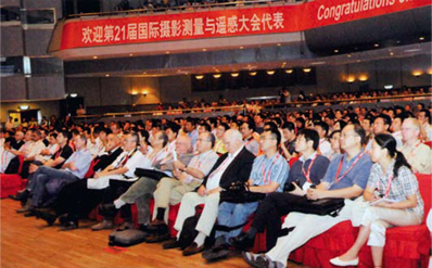
| The opening ceremony of XXI ISPRS (Society for Photogrammetry and Remote Sensing) Congress was chaired by Prof Yang Kai, President of Chinese Society of Geodesy, Photogrammetry and Cartography. Mr Lu Xinse, Vice Minister of Land Resources of China, Director General of State Bureau of Surveying and Mapping of China and Chairman of National Steering Committee for XXI ISPRS Congress, and Prof Ian Dowman, President of ISPRS, delivered opening addresses. The Brock Gold Award Medal was presented to Prof Armin Gruen; the Otto von Gruber Award to Dr Matthias Butenuth; the UV Heleva Award to Martin Raubal, Stephan Winter, Sven Tessmann and Christian Gaisbauer, and the inaugural Wang Zhizhuo Award to Prof Christopher Gold.
The congress was attended by more than 2700 individuals registered with more than 1500 international registrations from 76 countries. More than 2600 technical presentations were made during the congress. During the congress, over 100 international technology providers and local mapping agencies from 25 countries have show cased their latest products, solutions and applications to geospatial community. Beijing Declaration (Ratified on 9 July 2008)We, members of The International Society for Photogrammetry and Remote Sensing (ISPRS) and participants of the XXIst ISPRS Congress in Beijing, recognize the importance of imagery to measure and monitor the natural and man-made features on planet Earth and to explore other planets of the solar system, especially after witnessing the important role of photogrammetry, remote sensing and spatial information systems in the rescue operation and damage assessment of the recent devastating natural disasters. We note scientific developments reported during the technical sessions of the Congress and the great progress made in the use of imagery from many different platforms, with numerous sensors, for a wide variety of applications. We particularly note: 1. Wide applications of Earth observation technologies and tools to the fields of socio-economic sustainable development, natural disaster prediction, mitigation and response, maintenance of biodiversity, cultural heritage conservation, global and environmental climate change monitoring, energy exploration and management, land use and land cover inventory, food security, sustainable use of water resources, and human habitat, environment and health. 2. Significant technological achievement in the acquisition, processing, interpretation and analysis of aerial and satellite imagery, advances of airborne and terrestrial lidar, development of imaging radar technology, increased maturity of small satellites and of geo-sensor networks, validation, calibration and certification of digital cameras and other types of sensors, automated information extraction from all forms of imagery, distributed data processing for information services, and multidimensional data modeling. 3. Great progress in developing new forms of cooperation and knowledge sharing, including the Group on Earth Observation (GEO) and its program to establish a Global Earth Observation System of Systems (GEOSS), and the International Council for Science (ICSU) Geo-unions and its activities in Africa, and the Joint Board of Geospatial Information Societies.
Recalling that the 2002 World Summit for Sustainable Development (WSSD) stressed the importance of Earth observation for advancing sustainable development, we strongly believe that photogrammetry, remote sensing and spatial information sciences are essential to ensure sustainable development in the 21st century. We further recognize that nongovernmental organizations, especially ISPRS, have the responsibility to promote the peaceful use of space, airborne and terrestrial technology and the realization of the full potential of imagery for the benefit of society and for the maintenance of sustainable growth in all nations. We reaffirm our commitment to implement the vision for the 21st century of ISPRS, which aims to realize the full potential of information from imagery by encouraging and facilitating research and development, advancing knowledge by scientific networking, promoting international cooperation, pursuing interdisciplinary integration, facilitating education and training, enhancing and exploring new applications, developing public recognition of photogrammetry, remote sensing and the spatial information sciences. We therefore call on international communities to support the Cape Town declaration of GEO and: 1. to commit adequate investment and active engagement in scientific research and development, education and training, and capacity and infrastructure building; 2. to promote the sharing of imaging and ranging technology and data for scientific research and peaceful applications; and 3. to encourage constructive dialogue and close cooperation and collaboration between scientists, governments, public and private sectors, non-governmental organizations, and international organizations and institutions. We further call for a contribution from everyone to establish and operate a new silk road for information from imagery, leading to a peoplecentered and sustainable developmentoriented information society. |
||||


 (No Ratings Yet)


