| GNSS | |
Precise Orbit Determination of a Galileo/GIOVE-A Satellite
Using double differences of carrier phase measurements between GPS/Galileo satellites |
|
Abstract
GIOVE-A is a first Galileo test satellite launched on December 28, 2005. The satellite payload transmits two frequency signals at L1+E5 or L1+E6. There are 13 world wide located Galileo Experimental Sensor Stations (GESS) to track and monitor the GIOVE-A signals. High accuracy of GIOVE-A ephemeris or orbit, however, is essential for navigation applications. The paper presents a new method to deal with the precise orbit determination of GIOVE-A satellite using pure carrier phase measurements and the initial results [1].
It is well known that the highest accuracy of orbit determination can be achieved using double differences of carrier-phase measurements. But the problem for such a solution is that in order to use double differences of carrier-phase measurements, at least two Galileo satellites are needed. For GIOVE-A satellite, it is difficult to form such double differences as not enough Galileo satellites are currently in space. Therefore the GIOVE-A carrier-phase measurements combined with GPS measurements would be a reasonable solution. The paper presents a method called Double Differences of Carrier Phase Measurements Inter Constellations of GPS/Galileo (DDIC), i.e. double differences between GPS and Galileo satellites to determine the GIOVE-A satellite orbit.
In order to use DDIC, some problems shall be solved in advance, first of all the synchronization of GIOVE-A satellite measurements with GPS time reference, secondly the different time reference bias between GIOVE-A and GPS satellites, thirdly the different system bias between GPS and GIOVE-A satellites due to different coordinate systems and different system configuration and finally the weight normalization of GIOVE-A and GPS measurements for unified processing.
The time reference bias can be solved using navigation solution (or called PVT) with time synchronization with GPS time system, i.e. all the GIOVE-A measurements are corrected with GPS time parameters from the navigation solution. This step implied the synchronization of Galileo time with GPS time scale. The system bias is also solved at the navigation step, but later after the first solution of the orbit determination. After the time synchronization, the weight normalization can be taken place. The following factors are considered for the normalization, satellite orbit characteristics (altitude and movement, etc.) and measurement accuracy. Then GIOVE-A orbit is determined using double differences of carrier phase measurements between GPS/Galileo satellites. After the GIOVE-A orbit is determined, the GIOVE-A satellite clock corrections are solved separately using pseudorange measurements.
The initial results using one day of double differences (DD) (for GPS) and double differences inter GPS/Galileo constellation (DDIC) (for GIOVE-A) measurements show that the GIOVE-A orbit accuracy was achieved to about 20 – 80 cm level deduced implicitly from GPS orbit results compared with IGS final orbit. The implication means in this case, GIOVE-A is considered as another GPS satellite in the orbit determination. The accuracy will be further improved using multi-day measurements. The accuracy of the GIOVE-A satellite clock solution was in ns-level, but compared with GPS satellite clock solution, the GIOVE-A satellite clock bias increased quickly with time. For example, the GIOVE-A satellite clock bias was 800.522156 ![]() at 00:00:00 on Jan. 9 2008. The bias became 1258.956921
at 00:00:00 on Jan. 9 2008. The bias became 1258.956921 ![]() at 00:00:00 on Jan. 21, 2008. At the same time period, the determined GPS satellite clocks, for example, PRN02 Rb Clock corrections (processed with GIOVE-A satellite together) changed from 164.783651
at 00:00:00 on Jan. 21, 2008. At the same time period, the determined GPS satellite clocks, for example, PRN02 Rb Clock corrections (processed with GIOVE-A satellite together) changed from 164.783651 ![]() to 167.890185
to 167.890185 ![]() .
.
Introduction
Galileo is a satellite radio navigation system initiative launched by the European Union and the European Space Agency. Galileo will consist of a constellation of 30 satellites and ground stations providing position information to users.
Two experimental satellites were launched in 2005 and 2008 as part of the Galileo System Test Bed V2: GIOVE-A (Galileo In-Orbit Validation Element) and GIOVE-B (formerly GSTB-V2/B). The objectives of this mission are:
- to secure the Galileo frequency allocations by providing a signal in space
- on-board clock characterization
- MEO radiation environment characterization
- additional experimentation
The GIOVE-A satellite payload transmitted two frequency signals at L1+E5 or L1+E6 [1]. There are 13 world wide located Galileo Experimental Sensor Stations (GESS) to track and monitor the GIOVE-A signals.
High accuracy of Galileo ephemeris or orbit is a key for successful application of Galileo satellite system for navigation. There are some reports [5],[6],[7],[8] about GIOVE-A orbit determination using code or carrier-phase smoothed code measurements. It is well known that the highest accuracy of satellite orbit can be achieved using double differences of carrier-phase measurements. For the GIOVE-A satellite, however, it is difficult to form such double differences as not enough Galileo satellites are in space. Therefore in this paper, a new innovative approach to form such double differences of carrier-phase measurements between a GIOVE-A satellite and GPS satellites is presented. The initial results using this method to determine a GIOVE-A satellite orbit are also presented. This method is called Double Differences of Carrier Phase Measurements Inter Constellations of GPS/Galileo (DDIC) [1].
The new method is developed and implemented based on the Bernese GPS software version 5.0 further reworked for the GalTeC REF (Reference) component [4].
GalTeC is a development project under contract with the German Aerospace Center DLR and supported by the Federal Ministry of Economics and Technology (BMWi).
The application of GalTeC [3],[4] is to provide value added services related to the provision of GNSS satellite-only services. It provides services linked to GPS, GLONASS, EGNOS and Galileo satellite systems. The services comprise offline functional and performance analysis of the GNSS systems. GalTeC in addition offers prediction capability for service level and service volume assessment.
Giove-A satellite Orbit vs. GPS satellite orbit
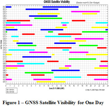
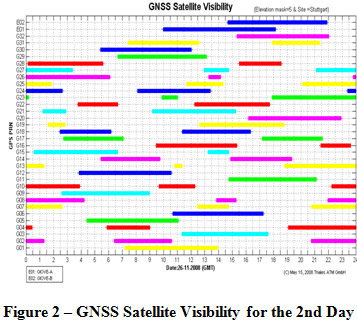
From the navigation users point of view, the GIOVE-A satellite orbit is a little different from a GPS satellite orbit. Each GPS satellite will complete two orbital revolutions around the earth for one day and the satellites will appear about 4 min. earlier each day (see figures ‘GNSS Satellite Visibility…’ below). For the users on the same sites the GPS satellite visibility is almost the same each day due to this reason. The GIOVE-A satellite, however, will complete 1.7 orbital revolutions around the earth for one day. Therefore the GIOVE-A satellite moves more slowly around the earth than GPS satellites. The satellite will rise about 6-7 hours later after one day and have a completely different path over the sky than the day before. Due to this difference, the ground monitoring stations can obtain more measurements from GIOVE-A satellite than from GPS satellites for the satellites with same altitude. About 3-4 days of measurements taking from one station can cover a whole arc of GIOVE-A satellite orbit. This is certainly a benefit for the accuracy improvement for orbit determination for GIOVE-A satellite, even with 13 GESS ground tracking stations.
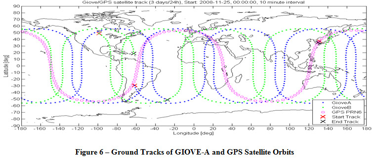
Figure 1 and Figure 2 show the GIOVE-A and GPS satellite visibility for a site in Stuttgart, Germany. The GIOVE-A is labeled with E01 and GIOVE-B with E02. Figure 6 shows ground tracks of GIOVE-A and GPS satellite orbit.
Overview of GIOVE-A and GIOVE-B Monitoring performance
Thales ATM has started to monitor GIOVE-A and GIOVE-B SIS (signal-in-space) performance since 2007 using a Septenterio GPS/Galileo receiver in the frame of the project GalTeC.
Reception Status of Giove A and B
Table 1 – GIOVE-A/B Reception Status
| A | B | A | B | A | B | ||
| Date | DoY | Reception | Eph Valid | PR Valid | |||
| Oct.01 | 275 | 1 | 1 | 0 | 0 | 1 | 0 |
| Oct.02 | 276 | 1 | 1 | 0 | 0 | 1 | 0 |
| Oct.03 | 277 | 1 | 1 | 0 | 0 | 1 | 0 |
| Oct.04 | 278 | 1 | 1 | 0 | 0 | 1 | 0 |
| Oct.05 | 279 | 1 | 1 | 0 | 0 | 1 | 0 |
| Oct.06 | 280 | 1 | 1 | 0 | 0 | 1 | 0 |
| Oct.07 | 281 | 1 | 1 | 0 | 0 | 1 | 0 |
| Oct.08 | 282 | 1 | 1 | 0 | 0 | 1 | 0 |
| Oct.09 | 283 | 1 | 1 | 0 | 0 | 1 | 0 |
| Oct.10 | 284 | 1 | 1 | 0 | 0 | 1 | 0 |
| Oct.11 | 285 | 1 | 1 | 0 | 0 | 1 | 0 |
| Oct.12 | 286 | 1 | 1 | 0 | 0 | 1 | 0 |
| Oct.13 | 287 | 1 | 1 | 0 | 0 | 1 | 0 |
| Oct.14 | 288 | 1 | 1 | 0 | 0 | 1 | 0 |
| Oct.15 | 289 | 1 | 1 | 0 | 0 | 1 | 0 |
| Oct.16 | 290 | 1 | 1 | 0 | 0 | 1 | 0 |
| Oct.17 | 291 | 1 | 1 | 0 | 0 | 1 | 0 |
| Oct.18 | 292 | 1 | 1 | 0 | 0 | 1 | 0 |
| Oct.19 | 293 | 1 | 1 | 0 | 0 | 1 | 0 |
| Oct.20 | 294 | 1 | 1 | 0 | 0 | 1 | 0 |
| Oct.21 | 295 | 1 | 1 | 0 | 1 | 1 | 0.5 |
| Oct.22 | 296 | 1 | 1 | 0 | 1 | 1 | 1 |
| Oct.23 | 297 | 1 | 1 | 1 | 1 | 1 | 1 |
| Oct.24 | 298 | 1 | 1 | 1 | 1 | 1 | 1 |
| Oct.25 | 299 | 1 | 1 | 1 | 1 | 1 | 1 |
| Oct.26 | 300 | 1 | 1 | 1 | 1 | 1 | 1 |
| Oct.27 | 301 | 1 | 1 | 1 | 1 | 1 | 1 |
| Oct.28 | 302 | 1 | 1 | 1 | 1 | 1 | 1 |
| Oct.29 | 303 | 1 | 1 | 1 | 1 | 1 | 1 |
| Oct.30 | 304 | 1 | 1 | 1 | 1 | 1 | 1 |
| Oct.31 | 305 | 1 | 1 | 1 | 1 | 1 | 1 |
| Nov.01 | 306 | 1 | 1 | 1 | 1 | 1 | 1 |
| Nov.02 | 307 | 1 | 1 | 1 | 1 | 1 | 1 |
| Nov.03 | 308 | 1 | 1 | 1 | 1 | 1 | 1 |
| Nov.04 | 309 | 1 | 1 | 1 | 1 | 1 | 1 |
| Nov.05 | 310 | 1 | 1 | 1 | 1 | 1 | 1 |
| Nov.06 | 311 | 1 | 1 | 1 | 1 | 1 | 1 |
| Nov.07 | 312 | 1 | 1 | 1 | 1 | 1 | 1 |
| Nov.08 | 313 | 1 | 1 | 1 | 1 | 1 | 1 |
| Nov.09 | 314 | 1 | 1 | 1 | 1 | 1 | 1 |
| Nov.10 | 315 | 1 | 1 | 1 | 1 | 1 | 1 |
| Nov.11 | 316 | 1 | 1 | 1 | 1 | 1 | 1 |
| Nov.12 | 317 | 1 | 1 | 1 | 1 | 1 | 1 |
| Nov.13 | 318 | 1 | 1 | 1 | 1 | 0 | 1 |
| Nov.14 | 319 | 1 | 1 | 1 | 1 | 0.5 | 1 |
| Nov.15 | 320 | 1 | 1 | 1 | 1 | 1 | 1 |
| Nov.16 | 321 | 1 | 1 | 1 | 1 | 1 | 1 |
| Nov.17 | 322 | 1 | 1 | 1 | 1 | 1 | 1 |
| Nov.18 | 323 | 1 | 1 | 1 | 1 | 1 | 1 |
| Nov.19 | 324 | 1 | 1 | 1 | 1 | 1 | 1 |
| Nov.20 | 325 | 1 | 1 | 1 | 1 | 1 | 1 |
| Nov.21 | 326 | 1 | 1 | 1 | 1 | 1 | 1 |
| Nov.22 | 327 | 1 | 1 | 1 | 1 | 1 | 1 |
| Nov.23 | 328 | 1 | 1 | 1 | 1 | 1 | 1 |
| Nov.24 | 329 | 1 | 1 | 1 | 1 | 1 | 1 |
| Nov.25 | 330 | 1 | 1 | 1 | 1 | 1 | 1 |
| Nov.26 | 331 | 1 | 1 | 1 | 1 | 1 | 1 |
| Nov.27 | 332 | 1 | 1 | 1 | 1 | 1 | 1 |
| Nov.28 | 333 | 1 | 1 | 1 | 1 | 1 | 1 |
| Nov.29 | 334 | 1 | 1 | 1 | 1 | 1 | 1 |
| Nov.30 | 335 | 1 | 1 | 1 | 1 | 1 | 1 |
| Days | 61 | 61 | 39 | 41 | 59.5 | 40.5 | |
| Percentage | 100.0 | 100.0 | 63.9 | 67.2 | 97.5 | 66.4 | |
In the table above the reception status of GIOVE-A and B for the months October and November 2008 are shown. A ‘1’ means that there was a reception of GIOVE signals or the received data are valid. A ‘0.5’ stands for partly correct reception (e.g. half a day) and a ‘0’ means no or no valid data. Within this time period on every day signals were received from the two satellites (columns: Reception). At the beginning of October no valid ephemeris (Eph) were sent from both GIOVE satellites (i.e. all data were zero or not reasonable). In the last two columns the received pseudoranges (PR) are evaluated. With the exception of 1.5 days GIOVE-A PRs are in the expected limits (see Figure 1 and 2). GIOVE-B PRs are valid since October 22nd. The two red marked days mean that there was received a set of ephemeris, but without clock correction parameters (i.e. af0, af1 and af2 were zero). At the orange marked days the pseudoranges are partly out of the expected range limits (>40000 km for Giove B, < 18000 km for Giove A).
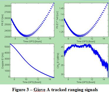
An overview of the received ranging signals is depicted in the following figures. The signals are received on 22nd November 2008 (DoY 327).
Due to the receiver setting a clock jump appears if the receiver clock error exceeds 500 µs. This leads to the jumps in the PR and carrier phase plots. The signal is tracked once the C/N0 is bigger than 28 dBHz.
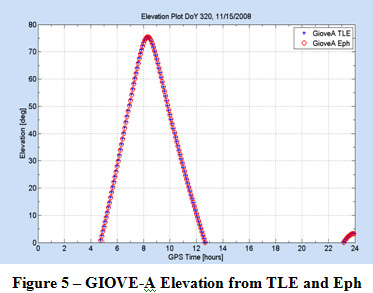
With the received ephemeris the orbits of GIOVE-A and B were calculated and compared with a solution derived from TLE (Two Line Elements). The differences in the norm of the position vectors reached from 40-100 km. The differences for GPS satellites are in a similar range. For illustration an elevation plot for GIOVE-A for DoY 320 (15th November 2008) is shown. This plot underlines that the received ephemeris are usable for orbit determination and thus for navigation purposes.
After three days the GIOVE-A satellite has covered a distance of about 5.1 orbits (revolution time of approximate 14 h 05 m). The start points are marked with red crosses and the final points with black crosses. For comparison also a GPS track (from PRN6) is shown in the Figure 6. After one day the GPS PRN6 is almost at the
same position as at the beginning of the track (revolution time of 11 h 58 m).
Giove-A Orbit Determination using DDIC
In order to use DDIC (Double Differences of Carrier Phase Measurements Inter Constellations of GPS/Galileo), some problems shall be solved in advance, first of all the synchronization of GIOVE-A satellite measurements with the GPS time reference; secondly the determination of different time reference biases between GIOVE-A and GPS satellites; thirdly the determination of different system biases between GPS and GIOVE-A satellites due to different coordinate systems and different system configuration and finally the weight normalization of GIOVE-A and GPS measurements for unified processing.
Time Synchronization
The synchronization of GIOVE-A satellite measurements with the GPS time reference is implemented as follows.
- perform PVT to get the GNSS receiver clock solutions using GPS broadcast ephemeris only
- applying the receiver clock corrections to both GPS and GIOVE-A measurements
The receiver clock correction related to the GPS time reference is solved and applied to GIOVE-A measurements. The step (2) implies that GIOVE-A measurements are synchronized with the GPS time reference. The remaining time errors in GIOVE-A measurements are GIOVE-A satellite clock errors including the different time reference bias which can be corrected after the GIOVE-A satellite clock errors are determined in the later steps.
Then the GIOVE-A satellite can be treated as another GPS satellite for further processing. The next steps for data processing are to form single differences of measurements and to detect and repair cycle slips in the measurements.
Different System Bias
The different system bias (or inter-system bias) is caused by different coordinate systems and the different system configuration between GPS and GIOVE-A satellites. The different system bias is introduced into the data processing for GIOVE-A and GPS orbit determination, but it cannot be directly separated at first. The bias is solved in a sequential approach, i.e. for the initial orbit determination, the different system bias is assumed to be zero. Thereafter GIOVE-A and GPS orbits as well as satellite clock corrections are determined. Then a PVT for each monitoring station will be performed again to solve the different system bias. The final orbit determination will be executed after the GIOVE-A measurements are corrected for the solved system bias.
Weight of GIOVE-A Measurements
The following factors are considered for the weighting of GIOVE-A measurements: satellite orbit characteristics (altitude and movement, etc.) and measurement accuracy. Since GIOVE-A measurements are synchronized with the GPS time reference, the GIOVE-A satellite is treated like another GPS satellite in the data processing. In order to simplify data processing for GIOVE-A and GPS measurements together, the weight of GIOVE-A carrier-phase measurements is assumed to be the same as for GPS measurements. The standard error is assumed to be 1 mm for GIOVE-A carrier-phase measurements.
Initial Orbit
In order to perform orbit determination of GNSS satellites or orbit improvement, the so-called initial orbit of GIOVE-A and GPS satellites is necessary. The initial GIOVE-A orbit can be obtained from the NORAD TLE or GIOVE-A broadcast ephemeris if the navigation ephemeris from GIOVE-A is valid or a predicted GIOVE-A orbit e.g. from ESTEC. The initial GPS orbit can be easily generated from the GPS broadcast ephemeris.
GIOVE-A Orbit Determination and Satellite Clock Solution
With initial GIOVE-A and GPS satellite orbits and all measurements from GIOVE-A and GPS satellites synchronized with the GPS time reference, double differences of carrier-phase measurements of ionosphere-free combinations between GIOVE-A and GPS satellites inter constellations (DDIC) can be formed to determine GIOVE-A and GPS satellite orbits together, i.e. DDIC can be formed as follows:
- If GIOVE-A measurements are synchronized with the GPS time reference, the time scale of the GIOVE-A satellite can be considered as GPS time and the GIOVE-A can be considered as another GPS satellite. For GPS and GIOVE-A carrier-phase measurements DDIC are then formed as follows.
- For GPS carrier-phase measurements among GPS satellites, DD can be formed as usually by the following equation:
where
![]() is the single difference between stations k and l for one of the GPS satellites or for the GIOVE-A satellite. The superscript indicates the satellite types.
is the single difference between stations k and l for one of the GPS satellites or for the GIOVE-A satellite. The superscript indicates the satellite types.![]() is determined by GIOVE-A carrier frequencies.
is determined by GIOVE-A carrier frequencies.
In forming double differences, the GIOVE-A satellite is not used as a reference satellite, therefore except for the GIOVE-A satellite, most of the double differences of measurements are still formed among GPS satellites and in this case the best accuracy of GPS and GIOVE-A orbit determination can be achieved.
In the orbit determination, the double differences among GPS satellites (DD) and the double differences between GPS and GIOVE-A satellites (DDIC) are processed together. Therefore, the accuracy of the GPS orbit determination is also impacted by the GIOVE-A measurement errors due to DDIC and vice versa for the accuracy of GIOVE-A satellite orbit. The orbit determination results are generally called DDIC results.
After the GIOVE-A and GPS satellite precise orbits are determined, the precise satellite clock solution can be obtained using pseudorange or carrier-smoothed pseudorange measurements with the new improved GIOVE-A and GPS satellite orbit determined by the orbit determination phase.
Initial Results
Precise Orbit Determination Results
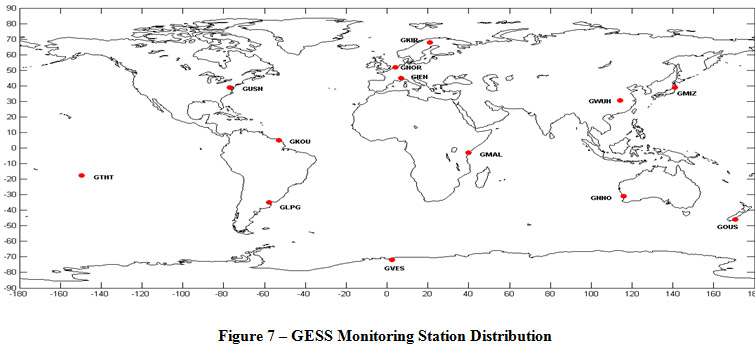
The raw measurements in the period from Jan. 9,2008 to Jan. 21,2008 from a ESA/ESTEC 13 GESS monitoring station network are used for GIOVE-A and GPS orbit determination (see Figure 7 and [2]). The GIOVE-A and GPS satellite raw measurements with a sample rate of 1 second are in RINEX 3 format. This data set has been kindly provided by ESTEC. The following table shows the measurement types used for GIOVE-A and GPS orbit determination. The orbit determination is processed on a daily basis, i.e. a one-day satellite orbit arc is determined using all measurements on that day. If the precise GIOVE-A and GPS satellite orbits are determined for a day, the orbits are predicted for the next day as the initial orbits, then the measurements from the next 24 hours are used for the precise orbit determination for that day. The process goes on in this way until all data has been processed.
Table 2 – GPS and GIOVE-A Measurement Relations
RINEX3 |
C1 | C2 | P1 | P2 | L1 | L2 |
GPS |
C1C (C/A) | C1P (P1) | C1P (P1) | C2P (P2) | L1C (L1) | L2P (L2) |
| GIOVE-A | C1B (E1) | C5I (E5a) | C1B (E1) | C5I (E5a) | L1B (E1) | L5I (E5a) |
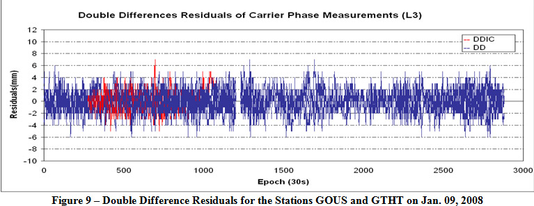
Some examples of the residuals of double differences of ionosphere-free combination (L3) among GPS satellites (DD) and between GIOVE-A and GPS satellites (DDIC) are presented in Figure 8 and Figure 9. In these figures, the residuals of the double differences among GPS satellites (DD) are plotted in blue colour and the residuals of double differences between GIOVE-A and GPS satellites (DDIC) are plotted in red colour.
These figures show that no significant differences between DD and DDIC are found. The residuals of DD and DDIC are both at ± 6 mm levels. It shows that the DDIC method is correct and able to be used for orbit determination of the GIOVE-A satellite with GPS satellites together.
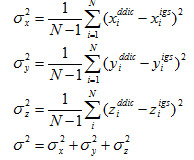
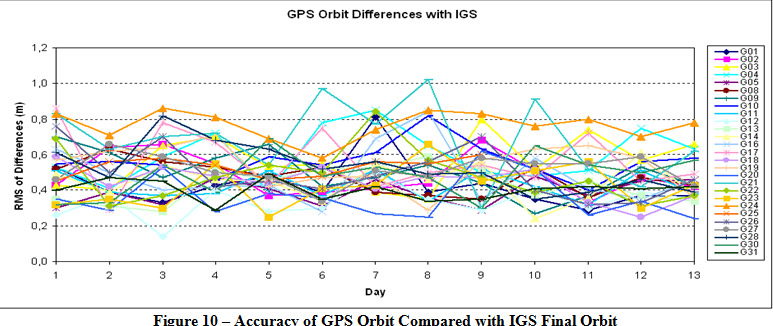
In order to further demonstrate the accuracy of daily orbit determination using the DDIC method, the results of precise GPS satellite orbits determined with the GIOVE-A satellite together are compared with IGS final orbits, the accuracy is evaluated as follows:
where
![]() are coordinates of a satellite in the WGS 84 coordinate system for a time epoch. The superscript ddic means the results of the orbit determination using DDIC method and igs the IGS final orbit.
are coordinates of a satellite in the WGS 84 coordinate system for a time epoch. The superscript ddic means the results of the orbit determination using DDIC method and igs the IGS final orbit.
The comparison results ![]() are shown in the Figure 10. In the figure the accuracy of the GPS orbit determination on a daily basis can achieve a level of around ±0.5 m. As the GIOVE-A satellite orbit can not be directly compared with a corresponding IGS orbit, its accuracy between ±0.2 m and ±0.8 m levels can be indirectly deduced from the shown GPS results in Figure 10 because no significant differences of residuals are found between DD and DDIC (see Figure 8 and Figure 9).
are shown in the Figure 10. In the figure the accuracy of the GPS orbit determination on a daily basis can achieve a level of around ±0.5 m. As the GIOVE-A satellite orbit can not be directly compared with a corresponding IGS orbit, its accuracy between ±0.2 m and ±0.8 m levels can be indirectly deduced from the shown GPS results in Figure 10 because no significant differences of residuals are found between DD and DDIC (see Figure 8 and Figure 9).
The accuracy of the GIOVE-A orbit can be further checked by comparing PVT results solved with GPS satellite orbits only and with both GPS and GIOVE-A satellite orbits together. Figure 11 shows the PVT results solved with GPS and GIOVE-A orbits. The figure displays that the RMSs of residuals of GPS pseudorange C/A code measurements are below ±1.0 m. The RMSs of residuals of GIOVE-A pseudorange measurements (C1B/E1) are also below ±1.0 m except on the second day (i.e. Jan. 10,2008). It is also indirectly shown that the accuracy of the GIOVE-A satellite orbit is compatible to the accuracy levels of GPS satellite orbits.
The Figure 12 shows the PVT results solved with the GPS broadcast ephemeris only. Here the RMSs are worse and reach values of up to ±5 m.
Results of Satellite Clock Solutions
Satellite clock corrections can be determined using pseudorange or carrier-smoothed pseudorange measurements after the GPS and GIOVE-A satellite orbits are determined. The Figure 13 shows the satellite clock daily solutions from Jan. 09, 2008 to Jan. 21, 2008, obtained from the data processing using pseudorange measurements with the GIOVE-A and GPS orbits determined using the DDIC method. From the figure the most of satellite clock solutions are in ns ![]() levels of accuracy. Figure 14 shows the satellite clock accumulation errors from Jan. 09, 2008 to Jan. 21,.2008. The accumulation errors of the satellite clocks since 09.01.2008 are calculated as follows,
levels of accuracy. Figure 14 shows the satellite clock accumulation errors from Jan. 09, 2008 to Jan. 21,.2008. The accumulation errors of the satellite clocks since 09.01.2008 are calculated as follows,
Pages: 1 2






 (No Ratings Yet)



Leave your response!