| Industry | |
INDUSTRY
GNSS & DGNSS tech expands SAILOR multi-function universe
SATCOM has launched two new SAILOR satellite navigation receivers. Both the SAILOR 656X GNSS and new SAILOR 657X DGNSS DGNSS are black-box products designed to be part of an innovative ecosystem Cobham SATCOM refers to as its ‘Multi-Function Universe’.
The advanced touch-screen SAILOR 6004 Control Panel forms the heart of the Multi-Function Universe, providing full control for all products connected to it from a single device. The SAILOR 656X GNSS and SAILOR 657X DGNSS join the already available SAILOR 6391 Navtex and SAILOR 628X AIS as new generation SAILOR products designed to work with the SAILOR 6004 Control Panel. www.cobham.com
NASA Awards Contract for Software, Maintenance to Esri
NASA has awarded a blanket purchase agreement (BPA) to Esri in Redlands, California, to provide geospatial software licenses and maintenance.
This BPA offers provisions for issuance of firm-fixed calls, with a one-year base ordering period, four one-year option ordering periods, and a potential contract value of $9.5 million. The contract will be administered by the Enterprise License Management Team at the NASA Shared Services Center (NSSC) at Stennis Space Center in Bay St. Louis, Mississippi. The NSSC performs select business activities for all NASA centers. www.nssc.nasa.gov
Satlab Geosolutions introduces SLD-100 Hydrographic Echo Sounder for GNSS Rover
Swedish based Survey and GIS equipment maker; Satlab Geosolutions AB, announces the availability of its SLD- 100 GNSS Rover accessory to facilitate Hydrographic measurement in bodies of water up to 100 meters in depth. With survey grade accuracy, it can be added to any brand GNSS RTK Rover to allow for position and depth measurements to be made simultaneously. With a built in 10 hour lithium battery and transmitter unit with Bluetooth connectivity, the it provides standard depth data streams in several industry standard NMEA formats at 1Hz, 4800 bps, providing compatibility with any Hydrographic Surveying software package. www.stalabgps.com
PCTEL launches new high rejection GNSS antenna portfolio
PCTEL, Inc has launched its new GNSS multi-satellite antenna portfolio for mobile and base station timing applications. Its new SkyLink [™ ] antenna technology features unmatched out-of-band rejection characteristics, which provide GPS/ Galileo and GLONASS L1 support and performance in heavy RF traffic environmentsfor fixed and mobile timing and asset tracking applications. The new portfolio consists of two product lines: SkyCompass™ for fleet management and asset tracking applications; and SkyStamp™base station antennas for timing and synchronization of 4G LTE cellular networks. www.pctel.com
Leica and Bentley team up for 3D photogrammetry
Leica Geosystems will incorporate Bentley Systems’ Acute3D software to generate full 3D from photogrammetric surveys To be used for both UAV and piloted aircraft, users can now produce true 3D models that reflect the real-world context in mapping and infrastructure applications, directly from digital photography.
Leica Geosystems has selected Acute3D software to generate full 3D “reality mesh” representations from its airborne photogrammetric imagery. This combination of software and hardware advancements will enable users to take full advantage of integrated 3D surveying and mapping. Through reality modelling, observations of existing conditions are processed into representations for contextual alignment – for instance, within design modelling and construction modelling environments, in addition to mapping. Rather than generating a voluminous cloud of discrete points, Acute3D produces a 3D reality mesh, readily aligning the real-world context in mapping and infrastructure applications.
Topcon Announces DS-200i Connectivity with Autodesk BIM 360 Layout App
Topcon Positioning Group has announced its DS-200i direct-aiming motorized imaging station’s compatibility with the new Autodesk BIM 360 Layout app for the Apple iPad. The DS-200i is the second total station solution that Autodesk and Topcon have collaborated on for contractors.
The DS-200i has an EDM (electronic distance measurement) range of up to 1000 meters (3280 ft.) without the need of a prism, and 5,000 meters (26,240 ft.) with one. The built-in wireless WLAN connects the iPad with the BIM 360 Layout app. The DS-200i features realtime video imaging with its 5 MP camera. The controller’s touchscreen video and arrow keys are designed to let remote operators view what is being measured, similar to looking through the telescope.
Honeywell’s Latest Navigation Technology for A320 and A330
Honeywell International Inc. has announced that its upgraded navigational technology will be available as an option on Airbus A320 and A330 aircraft in early 2018.
With the new Integrated Multi-Mode Receiver (IMMR), Airbus customers will gain access to the most modern precision navigation capabilities. The new navigation receiver will facilitate airline operators to leverage the most recent enhancements in satellite-based navigation. For example, they would be able to use Honeywell’s SmartPath Ground-Based Augmentation System (GBAS), which enables more accurate approach and landing access than today’s land-based systems. The new navigation receiver will also offer expanded capabilities for landing in very-low-visibility weather conditions.
Spectra Precision SP80 Wins Field Test Competition
The Agricultural Land Management and Statistic Department (ALMS) in Myanmar recently concluded comparative field tests of four leading models of GNSS receivers. The Spectra Precision SP80 swept to first in all tests. Based on the test results and bids, ALMS chose the SP80 and ordered 340 units. The comparative field tests included; positioning accuracy, initialization speed, internal radio performance, pole drop test, water immersion test to one meter, and on-board battery performance.
ALMS, under the Myanmar Ministry of Agriculture and Irrigation, has as its primary function land survey and map preparation in the maintenance of the nation’s agricultural land registry.
According to Chan Htun Aung of Suntac Technologies, the Spectra Precision dealer for Myanmar, the SP80 performed better than the competition under all conditions, and it did especially well under tree canopy.
Esri and Trimble Offer the R1 GNSS Receiver to Enhance Field GIS Workflows
Esri has announced the availability of the Trimble R1 Global Navigation Satellite System (GNSS) receiver for collecting professional-grade GPS data with Collector for ArcGIS. The GNSS receiver is rugged certified MILSTD- 810, IP65 rated, compact, and lightweight and provides professionalgrade positioning information to iOS, Android, or Windows mobile handhelds, smartphones, and tablets using Bluetooth connectivity for Bring Your Own Device (BYOD) capabilities.
Some users of Collector for ArcGIS on consumer-grade mobile devices might find their GPS to be less accurate than they need it to be. Now the locational precision of mobile devices can be enhanced via Bluetooth connected to the Trimble R1 GNSS receiver. The receiver is capable of supporting multiple global satellite constellation systems, including GPS, GLONASS, Galileo, and BeiDou, and delivers GNSS positions in real time without the need for postprocessing. www.esri.com/news.
Supergeo Cooperates with GNSS Solution Provider, CHC Navigation
Supergeo Technologies Inc., is now building a bridge with the fast-growing GNSS/GPS solution provider, CHC Navigation. SuperSurv, the mobile GIS product of SuperGIS, was selected as the value-added software that could be pre-installed for CHC users.
The combination of SuperSurv and CHC devices brings the possibility of getting sub-meter accuracy GIS data with reasonable costs. The result is the premier solution for researchers or workers that need to frequently work in the field. www.chcnav.com/
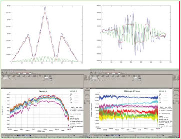
JAVAD GNSS TRE-3 Successfully Tracks First Live TMBOC Signal
Newly launched BeiDou Phase 3 satellites have several new signals. One is extremely similar to future GPS L1C signal with time-division BOC(1,1) and BOC(6,1) signals. Such type of modulation is called TMBOC. Using the same approach, as described in an article at gpsworld. com, the signal structure was decoded and L1C TMBOC tracking has been successfully tested on TRE-3 receiver.
In addition, new signals on 1575.42+1.023*14 MHz (B1-2), 1176.45 MHz (E5A) and 1207.14 (E5B) frequencies for three satellites (prn 32, 33, 34) have also been decoded and tested. Some graphs, illustrating the experiment:
I of BOC(1,1) (red), BOC(6,1) (green) and their sum (blue) vs code shift.
dI of BOC(1,1) (red), BOC(6,1) (green) and their sum (blue) vs code shift.
Horizontal axis: 0 – munus one chip chift; 327 – zero shift; 655 – plus one chip shift C/NO and iono-free “range munus phase”.
Slot – Beidou signal
C/A – B1
P1 – B1-2
P2 – E5B
L2C – B3
L5 – E5A
L1C – L1C


 (No Ratings Yet)


Leave your response!