| GNSS | |
GNSS interference and signal degradation events assessment
This paper compiles all the events (interference or signal degradation) detected by ENAIRE in several Spanish Airports during 2015 in order to provide a snapshot of how these threats are affecting GNSS performances |
 |
|
 |
|
 |
|
 |
|
 |
|
 |
|
ENAIRE, as the Spanish Air Navigation Service Provider (ANSP), contributes to the PBN policy and its implementation in Spain. PBN makes use of GNSS systems, such as GPS, as a primary source for position and navigation. One of the steps included in a PBN GNSS (both GPS/RAIM and SBAS) and GBAS based procedure implementation is an assessment of the GNSS interference in the vicinity of the airport.
GNSS interference detection and mitigation has become a topic of utmost for all the stakeholders in aviation. GNSS systems are increasingly being used to perform Instrument Flight Procedures, and interference may lead to a loss of navigation capabilities when a procedure is being flown.
The GNSS Intentional Interference and Spoofing Study Team (GIIST) stated [2] some findings that are confirmed in this paper:
• Civil aviation use of GNSS is vulnerable to intentional interference/spoofing.
• Threat of interference and spoofing is likely to increase.
This paper is aimed to present a summary of all the interference degradation events registered in different Spanish Airports during 2015, focusing on jamming events. Additionally, other objective is to open a debate in the navigation community about the risks of GNSS interference in aviation and study if further measurements or regulation could be introduced.
Interference detection process in ENAIRE
For the reasons presented in the introduction, ENAIRE has built a wide network of GNSS receivers and interference detectors, among other capabilities, in many airports in Spain. The interference detection capability is part of the ENAIRE GNSS Lab. As it can be seen in the following sections, a very simple approach to GNSS interference detection has been established based on two different methodologies.
GPS L1 band spectrum monitoring
srx-10i/DINTEL [3] is a complete GPS/ Galileo spectrum monitoring, interference detection and analysis system in the L1/E1 bands fully developed by GMV [4] following the ICAO Annex 10 [5] and Doc 8071 [6] recommendations.
The system has been designed to fulfil the need of spectrum monitoring whenever GPS (and Galileo in the future) is used in support of the operation of critical infrastructures such as airports. The system offers the following benefits:
• Uninterrupted, automatic operation for continuous monitoring of disruption events due to interference in the GPS/Galileo L1/E1 bands
• Identification and characterization of interference sources (spectrum, power and time)
The srx-10i/DINTEL records raw digital samples whenever an interference event is detected, and includes a built-in analysis tool for later postprocessing and detailed assessments.
The system can be easily integrated in already existing GNSS monitoring networks (e.g. GPS or EGNOS monitoring systems) and with existing alert management systems.
Finally some of the main features of this system are:
• Supported bands: GPS L1 and Galileo E1
• Bandwidth: 16 MHz (1575.42 ± 8 MHz) @ 1 bit
• Configurable interference mask. Default mask is defined as Annex 10 [5]
• Configurable spectrum resolution (100 Hz to 50 KHz)
• Outputs:
– Power Spectral Density (PSD) in the L1/E1 bands
– Detected interference features: central frequency, bandwidth, power.
GPS Signal to Noise ratio analysis
With the objective of completing the detection of any degradation in GPS signals, a recurrent study of behaviour of GPS Signal to Noise ratio was introduced. Signal to noise ratio is one of the Interferences parameters defined in ICAO 8071 Document [6]. This checking uses all the data stored by the ENAIRE Receivers Network (RECNET) (See section III for more information). In consequence, 24h/7d data from all the receivers is taken into account.
The process consists of a C/N0 trend analysis of each GPS and EGNOS satellite in an individual manner. Some previous parameters must be configured before launching the analysis. These parameters are the following:
• Signal to Noise drop threshold.
• Time window in which the drop is produced.
• Number of GPS satellites affected.
Previous experience has demonstrated that low restrictive conditions on these parameters could lead to a vast number of events to be analyzed while high restrictive conditions could lead to some degradation misdetections.
Once the degradation events are identified, they are crosschecked against srx-10i/ DINTEL and against some GNSS parameters such as tracked satellites, used satellites, position accuracy or EGNOS Protection Levels.
It has to be remarked that the events detected using this technique are only treated as signal degradation. If there is no spectrum recorded the interference cannot be confirmed. It could be provoked by an out of band interference or any other issue that could not be defined.
These two techniques have led to a surprisingly high rate of interference and potential signal degradation detected. All the background obtained from this analysis, represents just first milestone if real and effective GNSS spectrum protection wants to be achieved. Interference localisation, GNSS spectrum protection, mitigation or transnational regulations are topics that will need further efforts in the future.
Enaire GNSS Laboratory Capabilities [7]
ENAIRE GNSS lab was established as an independent way of analyzing GNSS performances, detection and first analysis of GNSS interference. Lab objectives help to demonstrate GPS and SBAS can meet the required navigation performances and to verify Service Level Agreements (SLA). This functionality will be increased with the capacity to analyse periodically GBAS CAT I performances and possible interference in Málaga Airport.
Performance monitoring is also needed to warn users about any service gap or degradation to take appropriate recovery actions. In this context, the lab is responsible of issuing EGNOS performance weekly reports in the Spanish airports, GPS monthly reports in Spain and identifying and characterizing GNSS L1 interference in Spanish airfields.
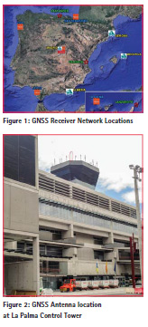
The foundations of ENAIRE GNSS lab are its network of GNSS stations distributed throughout the Spanish geography. With a total of ten receivers, nine are located in the control towers of Almería, Gerona, Jerez, La Palma, Lanzarote, Menorca, San Sebastián, Santander and Vigo, while the remaining two are set in the Valencia TACC and the RIMS shelter in Málaga Airport (This station was not operative in 2015 and no results have been included in this paper). The network of GPS and EGNOS receivers and GPS L1 interference detectors stores data 24h/7d which is later on analyzed by GNSS performance experts.
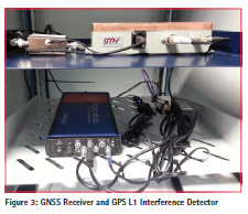
Each station is composed by a GNSS antenna, a GNSS receiver and a GPS L1 interference detector. All the stations are installed on the rooftop of control towers of the airports mentioned above.
ENAIRE lab is concerned about the intentional or unintentional use of L1 jammers in the proximity of civil aeronautics receivers. Certified receivers are not specifically designed to track GNSS in an environment with interfering signals. ICAO clearly defines what kind of signals and level of received power can be considered a threat [6]. Through the commercial front-end srx-10i/DINTEL [3] (see section II), the GNSS lab identifies GNSS L1 interference according to ICAO. The front-end installed at the GNSS stations automatically analyzes GPS L1 spectrum and sends alarms every time interference appears. Data is logged and analyzed by DINTEL software. Interference events are characterized by the frequency of each peak [MHz], power of the peak [dBm], estimated bandwidth [KHz], and total interference power. The monitor of GPS spectrum is done automatically 24h/7d.
A second analysis is performed in order to ensure that all possible signal degradation or potential interference events are actually affecting navigation and GNSS performances. Signal to noise ratio analysis of the GPS and EGNOS signals could lead to a second GNSS signal degradation detection. ENAIRE studies C/N0 for all the data stored from the GNSS receivers and analyses the effect of any deviation of a nominal behaviour of this ratio.
Interference events detected with DINTEL
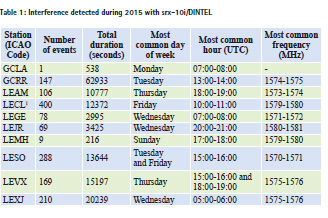
This section of the paper is intended to present the main statistics of all the interference events detected by srx-10i/DINTEL during 2015 in the airports where GNSS receivers and interference detectors are installed. Every interference event has been classified by airport, day of week, hour, and frequency as a first step to obtain a pattern leading to a better future identification and localisation. Table 1 summarises all the events detected in every airport and the most common measurable in which the events were classified.
Table 1 shows very different results depending on the location. La Palma Airport (GCLA) is the only one without any event detected during 2015. This behaviour is completely different to the other station located in the Canary Islands (Lanzarote (GCRR)) where interference events where detected the 0.2% of the total time in the year.
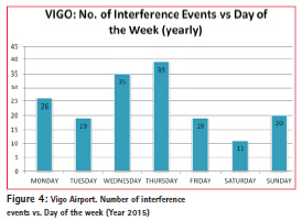
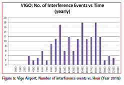
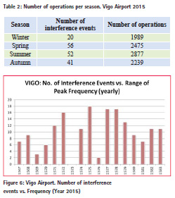
On the other hand, there are some aspects that are common to all the locations. The most common day of the week and hour when interferences were detected, were labour hours and days. If a location is studied in detail, it can be easily found the repeatability in the occurrence of the interference events. One of these scenarios is Vigo Airport, where 9580 aircraft movements were registered during 2015[8].
In 2015, Vigo interference detector station registered 169 interference events with a total duration of 15197 seconds. It represents a medium duration of 90 seconds each event.
In order to better characterize the repeatability of the events, all of them have been classified by day of week and hour of occurrence. The results are shown in Figure 4 and Figure 5.
Vigo Airport hours of operation are comprised between 06:30 to 00:30 UTC [9]. 155 of the 169 interference events registered took place during the hours of operation in the airport. In addition, Thursday is the day when more regular operations are scheduled.
The frequency of the events has also been classified depending on the season of the year. In Table 2, it is shown a comparison between the number of interference events and the number of operations according to AENA Air Traffic statistics [8] separated by season. It can be also seen how the seasons with the highest number of operations (spring and summer) have also the highest number of interferences events.
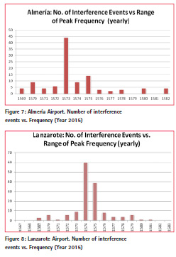
Finally, all the events were classified by the frequency in which a peak exceeding ICAO mask was detected. It was used a step of 1MHz from 1567 to 1584 MHz.
In this case, no conclusions can be derived from the results since no clear repeatability is detected. Nevertheless, frequency will be observed in each airport to fl ag any interference whose rate of occurrence were remarkable.
In Almería and Lanzarote airports a clear pattern can be found, regarding frequency of occurrence. In Almería 44 of 106 events affected at 1573 MHz and in Lanzarote 99 of 147 events affected at 1574 or 1575 MHz.
GNSS signal degradation detected with C/N0 analysis
Derived from the analysis of the signal to noise ratio of the GPS and EGNOS satellites, a wide number of events has been categorised as possible interference.
Due to the amount of data obtained in 2015, no statistics have been obtained. In next section, it will be shown all the interference events that actually have affected GNSS performances. It includes all the events either detected by DINTEL or by C/N0 analysis.
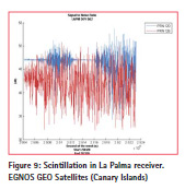
Regarding the C/N0, other possible affections of GNSS signals have been detected. These events have helped to better understand and explain some misbehaviour of GNSS performances. Scintillation, mainly located at south Iberian Peninsula and Canary Islands, and EGNOS GEO malfunction are some of these events.
Affection to GNSS Performances
The second step after the detection and identification of the anomaly is to analyse whether the events have had impact on GNSS Performances (GPS and SBAS solution). Depending on the severity of the interference events, these are classified in three different types from the least to the most severe: • Disruption of APV-I EGNOS capabilities. (Type 1).
• Denial of EGNOS service. (Type 2)
• Denial of GPS service. (Type 3)
The first type means that the EGNOS Protection Levels have been affected to the point of exceeding the APV-I alert limits (All the interference events in this document have been compared against APV-I requirements (HAL=40 m and VAL=50m)). The second type means that the track of GEO EGNOS satellites has been lost or the necessary number of satellites to compute EGNOS solution is not reached. Finally, the third type means that the receiver tracks less than four usable satellites necessary to compute GPS Solution and consequently the navigation and positioning capacity.
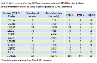
The total number of events affecting GNSS performances detected in the ten sites was 105 with a medium length of approximately 500 seconds each event. All these events affected to the APV-I EGNOS availability, 64 disabled the EGNOS capabilities and 20 of them completely denied the GPS navigation solution. In the next paragraphs, it will be described an example of interference detected by srx-10i/DINTEL and by the recurrent analysis of the signal to noise ratio.
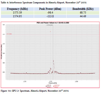
One of the interference was detected in Almeria Airport (LEAM) on November 23rd 2015 from 18:42:19 to 18:49:13 UTC. It has to be remarked that in Almería Airport there are published RNP APCH procedures down to LPV, LNAV and LNAV/ VNAV minima to THR 25[10] & [11]. srx-10i/DINTEL detected this interference in two different frequencies that exceeded the limit of the ICAO Mask for the Continuous Wave Interference (-120.5 dBm). The frequencies, peaks values and bandwidth of each interference spectrum components are shown in Table 4.
The plot of the spectrum recorded and its comparison with the ICAO Mask is shown in the Figure 10.
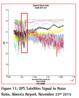
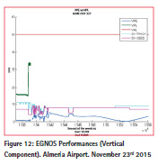
In parallel, and making use of the GNSS raw data stored by the GNSS receiver, the C/N0 of each satellite was analyzed in order to confirm if this event had affected any GNSS observable or if there was another undetected degradation. The C/N0 of all the GPS Satellites in view is shown in Figure 11.
The maximum power measured was detected at 18:45:11 when it is observed that the receiver lost the track of all the GPS satellites. It was due to the drastic drop of the signal to noise ratio in all the satellites that GPS Solution was lost for a few seconds. At the same time, the receiver lost EGNOS capabilities which took some minutes to recover the track of EGNOS GEO corrections.
Interference events and its impact in real operations
The previous sections were focused on the interference events registered using receivers located on the rooftop of the control towers, which can be considered at ground level. According to [6] this scenario is suitable for interference detection during takeoffs and landings at airports; however there are other events that cannot be covered by this configuration.
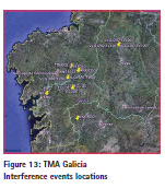
One of these examples is the loss of GPS capabilities reported by several aircraft on December 2015 in TMA Galicia (north-west of Spain). In total, there were eight GPS loss of navigation events reported from 30th November 2015 to 14th December 2015. The altitudes of the fl ights were comprised between 5000 ft to 12000 ft. All these events were classified as jamming due to the fact of the unavailability of the GPS constellation instead of false positions which would mean spoofing.
Following the notification of these events, ENAIRE GNSS department performed a study, in which, some ground receivers data were assessed. In this study, the GPS raw data was analyzed in order to confirm if any degradation was recorded at ground level. The GPS stations used to perform the study belong to the GNSS receiver’s network, from IGN [12] and from GALNET [13].
Data from two hours before and two hours after each aircraft report were analyzed from the closest GNSS ground stations of the mentioned networks. The results did not show any degradation that confirmed affection at ground level. In addition, any GPS constellation issue was discarded since the geometry remained optimal during those days.
These kinds of events demonstrate that interference is an issue that can have hazardous effects at every flight level. For some PBN applications where only GNSS can support its implementation, this kind of interference could jeopardize the nominal operation and put at risk the safety operation, if no mitigations are considered.
Conclusions and future steps
Interference events caused by jamming, whether if it is intentional or unintentional, has been demonstrated as an important threat which endanger GNSS signals. This degradation has an impact on the availability of maneuvers relying on GNSS that ENAIRE has published or it is aimed to publish in the near future.
This paper has shown the process performed by ENAIRE to detect GNSS interference. It represents only the first step in terms of detection given that further actions are being studied. Some of these activities comprise interference localization and inclusion of interference events in the ATC Interface, along with GNSS NOTAMs publication using the interference detectors network presented in this paper.
The number of interference events should be negligible due to the fact that mitigation activities are being developed to deal with this issue. This subject has been discussed in the ICAO Navigation Systems Panel (NSP) during the last years within a dedicated item in the agenda. This panel is involved in developing guidance on radiofrequency interference to GNSS and on potential mitigations [14]. Mitigations activities imply three different perspectives:
• Include standardized protection mechanisms against the threats from repeaters/pseudolites/jammers within commercial GNSS receivers.
• Taking advantage of conventional navigation aids and radar, or alternative position, navigation and timing systems (APNT).
• States should implement adequate policies and procedures to regulate and protect GNSS spectrum.
The regulation should be the primary way to reduce the impact of GNSS interference, as it is stated in the GNSS Manual [15] GNSS frequencies are protected for aviation use and coordinated actions and regulations should be considered at International or European level.
References
[1] ENAIRE – http://www.enaire.es/
[2] Interna tional Civil Aviation Conference, ‘Navigation System Panel- Update on FAA GNSS Interference Mitigation Activities”-NSP/2-IP/23.
[3] GMV Aer ospace and Defence, srx-10i, http://www.gmv.com/ en/space/products/srx-10i
[4] GMV – h ttp://www.gmv.com/
[5] Interna tional Civil Aviation Conference, ‘ICAO Annex 10 – Aeronautical Telecommunications” – Volume I – Sixth Edition amendment 89, November 2014.
[6] Interna tional Civil Aviation Conference, ‘ICAO Doc 8071 – Manual on Testing Radio Navigation Aids” – Volume II– Fifth Edition amendment 1, April 2008
[7] ENC 201 3 – ENAIRE – GNSS Performance Based Navigation Procedures Validation.
[8] AENA- “ 2015 Air Traffic Statistics”- http://www.aena.es/ csee/ccurl/483/1011/Copia%20 de%2012.Estadisticas_ Diciembre_2015.pdf
[9] AENA – “AIP Spain” – http://www. enaire.es/csee/Satellite/navegacionaerea/ es/Page/1078418725020/
[10] ENAIRE, ‘Instrument approach chart-OACI Almería RNAV (GNSS) Z RWY 25’ 2015.
[11] ENAIRE, ‘Instrument approach chart-OACI Almería RNAV (GNSS) Y RWY 25’ 2015.
[12] IGN Recei vers Network, http:// www.ign.es/ign/layoutIn/ geodesiaEstacionesPermanentes.do
[13] GALNET Re ceivers Network, http://www.topcadingenieria. com/index.php/investigaciondesarrollo- uav/red-gnss-galnet
[14] Internati onal Civil Aviation Conference “Increased protection of aviation GNSS receivers from harmful effects from ground radiators (repeaters/ pseudolites). NSP 2014 October.
[15] Internati onal Civil Aviation Conference, ‘ICAO Doc 9849 – GNSS Manual”– Second Edition, 2013. The paper was presented at ENC 2016, 30 May – 2 June 2016, Helsinki, Finland


 (8 votes, average: 4.75 out of 5)


Leave your response!