| Geodesy | |
Geomagnetic observations and measurements in Israel
This paper presents a brief overview of the various activities of the Survey of Israel in the geomagnetic sphere, including ongoing and future projects, such as prediction of magnetic declination based on absolute declination annual measurements and formulation of an interactive comprehensive declination model |
 |
|
 |
|
 |
|
One of the oldest studies in geophysical sciences is geomagnetism – the study of Earth’s magnetic field, also referred to as the geomagnetic field. The phenomena associated with the geomagnetic field have been researched and monitored for centuries by many countries throughout the globe, mainly for its imperative role in protecting the biosphere of our planet. The surrounding geomagnetic field deflects away from Earth a substantial amount of plasma streamed from the sun in high velocities and extreme temperature – the solar wind. The interaction between the solar wind and the magnetic field of the Earth forms the magnetosphere, without which sun flares would erode Earth’s atmosphere rendering it vulnerable to space radiation and thus uninhabitable.
Additionally, there is a strong connection between the discovery and motion of continents as well as exploration of oceans and the probing of the Earth’s magnetic field (Wardinski, 2005). Another benefit of geomagnetic studies is the capability they provide to search for mineral aggregates such as metal ores. However, the most popular use of the Earth’s magnetic field observations, ever since the discovery that a compass needle does not in fact points to the geographic north, is for orientation and navigation purposes.
Given the above, systematic observation and monitoring of the geomagnetic field are of a great importance. Much effort has been devoted to research in order to further explore and achieve greater understanding of the magnetic field of the Earth. To this end, observatories worldwide were established as well as designated satellite network and analysis centers.
The Survey of Israel joined the geomagnetic collaboration nearly 40 years ago. Thenceforth its primary goal was to define the direction of the magnetic north in Israel and to determine its yearly variation as well as to carry out geomagnetic measurements, to process acquired data and to provide the data to the global geomagnetic network affiliated with IAGA (the International Association of Geomagnetism and Aeronomy).
Sources of Earth’s Magnetic Field
Earth’s magnetic field is very complex. It is commonly represented as a superposition of both internal and external sources. While the dominant component of all is, the Main Field or the Core Filed, which is produced by the electrical currents originated in the Earth’s core. According to Paleomagnetic records (the record of the strength and direction of the geomagnetic filed preserved by rocks – fossil records), the geomagnetic filed was initially created approximately three billion years ago. However, due to Earth’s core characteristics, such as size and electric conductivity, it would have been not able to sustain for billions of years. Dynamo theory is an explanation offered by scientists for this phenomenon that suggests a mechanism in the Earth’s outer fluid core that constantly generates the geomagnetic Main Field. Second contributor to the internal components is the Crustal Filed, also known as Lithospheric or Anomalous Field, which is caused by magnetic minerals in the crust and upper mantle. The external source called the Combined Disturbance Field is the product of electrical currents in the ionized upper atmosphere and magnetosphere (Amm, 2016, Chulliat et. al., 2015). Therefore, the Total Earth’s magnetic Field B (also denoted as F) is a vector quantity represented by the sum of its components:
(1) BTotal = BCore + Bcrust + BDisturbance
The mathematical methods used to denote the geomagnetic Main Filed, are very complex; several models based on spherical harmonic functions can be applied, among them the International Geomagnetic Reference Field (IGRF) and World Magnetic Model (WMM). However, the Dipole Model, which is the first order approximation of the Earth’s magnetic field, provides a good description. This model views the Earth, as a spherical magnet whereas the generated filed resembles a dipole, with North and South poles located near the South and North geographic poles respectively. Those are theoretical antipodal poles connected by the dipole axis, which is tilted by about 11 degrees relative to the Earth’s rotation axis.
Geomagnetic field components
The Earth’s magnetic field is a vector quantity, i.e. it is characterized in a specific point by its direction and magnitude, which has different values at any given time or location. The geomagnetic field can be described by seven elements. These include the Total Field (total Intensity) – and its three perpendicular components: the Northerly Intensity -, the Easterly Intensity – and the Vertical Intensity (Down Intensity) -; the Horizontal Intensity – and two direction angels the Declination angle D and the Inclination angle I (Wardinski et. al., 2015). The magnitude is generally given in Nano-Tesla (nT) and the angular elements are measured in arc Degrees, Minutes and Seconds (DMS).
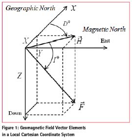
The Inclination or the Magnetic Dip angle is defined as the angular distance from the horizontal plane to the Total Filed vector and receives positive values downwards. Counter to Geomagnetic Poles, the Magnetic Poles represent the area on the surface of the Earth where I is or in other words, the Horizontal Intensity of the geomagnetic filed equals to zero.
At any given point on Earth, the compass needle aligns itself with the Horizontal Component or the Magnetic North direction, which does not coincide with the Geographical or the True North direction. The difference between these two directions, which is measured clockwise from the True North toward H, is the Declination angle or the Magnetic Variation. D is considered negative toward the West.
A Cartesian Coordinate System, with X axis pointing to the geographical North, Y to the East and Z downward, is often employed in order to represent the Earth’s magnetic field parameters, as given in Figure 1.
Geomagnetic Measurements
Earth’s magnetic field is constantly changes in time. These changes can be classified into two main categories: long-term and short-term variations. The former is referred to as Secular Variation and reflects the annual changes in the field. Whereas the latter depicts rapid changes due to magnetic activities. Expression of these changes is manifested in the inconsistent values of the Declination.
Earth’s polarity is not a constant and has a pattern of pole reversals every 200000 to 30000 years. During the last centuries, the magnetic field has been weakening, which may serve as an indication to yet another approaching pole reversal. Such an event will have devastating implications on life on Earth in general and humankind in particular. Furthermore, in the short run changes in the magnetic field influence numerous applications in navigation practices, equipment calibrations and research in various fields.
Monitoring of the changes in geomagnetic field requires two types of measurements: Absolute discrete measurements and continuous observations of field’s Variations. Absolute measurements, which are commonly carried out on a weekly basis, include the two angular components: Declination and Inclination (in DMS) and the Total Filed magnitude – F (in nT). The vector components are then obtained using the following equations:
(2) X = B* cos I *cos D
Y = B *cos I *sin
D Z = B *sin I
Magnetic Variations recordings are performed in observatories. The main objective of the geomagnetic observatories is to continuously monitor the changes of the three field’s components ΔX, ΔY and ΔZ over long period of time and to maintain the accurate absolute value of the field in a fixed location and at a certain time (Amm, 2016).
Geomagnetic observations in Israel
Magnetic Observations in Israel are performed by the Survey of Israel, which is a government agency for Mapping, Geodesy, Cadastre and Geoinformatics. Israel is part of the global network of magnetic observatories and was established with the following objectives in mind:
1. To determine the local magnetic Declination (magnetic North) within the borders of Israel and to monitor its annual changes.
2. To map the geomagnetic field components.
3. To provide data and services to various organizations, such as Israel Defense Force and civil aviation companies.
4. To contribute to the global geomagnetic network by supplying magnetic data to World Data Centers.
5. To provide data for research work in fields of geology, geophysics, archeology, etc. to research facilities both nationally and internationally.
6. To carry out studies in different areas related to geomagnetic field measurements, e.g.: super sensitive magnetic gradiometer, the Dead Sea sinkholes, cosmic weather, geological deep structure, tunnels detection, etc. (Shirman, 2016).
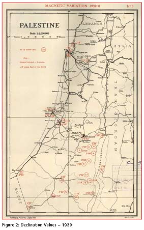
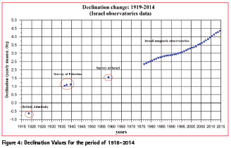
During the period of the British Mandate, the British Admiralty carried out the first geomagnetic measurements of the Declination in 1918. Following are the values obtained in several locations along the coastal zone: Atlit – 0° 15’ W; Caesarea – 0°20’ W, Yafo – 0° 25’ W; and port Yavne – 0° 20’ W. In the years of 1917-1948 Magnetic Variation measurements were continued by Survey of Palestine at several stations located in the central area of the Mandate territory as well as along the cost.
Figure 2 presents an archive map depicting Declination values recorded by the Survey of Palestine. It is important to note that all values are East of the True North, contrary to the values recorded in year of 1918, with values ranging between and Additionally, the Declination value at the coastal area and the central area is about 30’.
Further Magnetic Variation measurements were carried out by the Survey of Israel in 1958 at three locations along the coast and from there after at the magnetic observatories.
Regular geomagnetic observations in Israel started in 1976 with the establishment of the Amatsia magnetic observatory, located in the center of Israel. The Bar-Gyora observatory was opened in 1989 and has been operating simultaneously with Amatsia for several years. Presently there are three active observatories, which serve for the purposes of continuous magnetic data acquisition and monitoring: Mt. Hermon (in the North), Bar-Gyora (in the Center) and Eilat (in the South) observatories. Bar-Gyora is the central station that provides data to the World Data Center along with Eilat observatory. Weekly absolute measurements of Total Field, Declination and Inclination are performed at the observatories’ locations as well.
For the past 40 years, Research Division of SOI has been responsible for performing geomagnetic observations, processing the acquired data and supplying it to numerous organizations for navigation and mineral exploration purposes, geological and geophysical studies, as well as for various research projects. Following a brief review of the observed data.
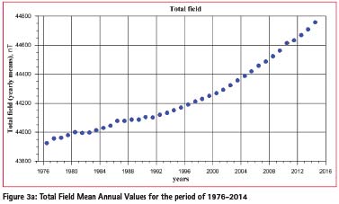
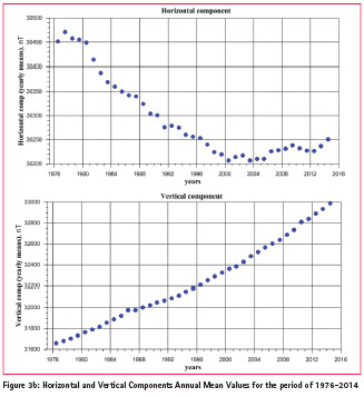
Figure 3 presents the Secular Variations of the geomagnetic field. The changes are shown in Total Field values as well as in Horizontal and Vertical components (Figures 3a and 3b respectively).
It is worth mentioning that contrary to the global trend of decreasing magnetic dipole, the total filed at certain areas, like Israel, is growing stronger.
As mentioned earlier, changes in the geomagnetic filed are reflected in the Declination values as shown in Figure 4. As can be clearly seen from the chart, over the past century or so, there has been a monotonic increase in Declination values. Starting at approximately 0.3 degrees to the West and growing toward 4.5 degrees to the East nowadays. These changes correspond to the Horizontal Component decrease at a rate of 5 to 20 nT per year.
Geomagnatic mapping in Israel
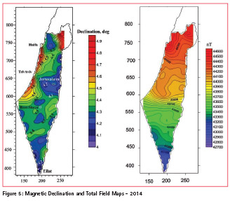
One of the most significant efforts undertaken by the Survey of Israel is mapping. Given that Delineation measurements are vastly used for navigation and cartography, manufacturing of geomagnetic charts is a priority service. To facilitate this requirement a repeat station network was established including Amatsia and Bar-Gyora observatories. Measurements were performed during two surveys taking place in 1984 and 1993 years.
Figure 5 depicts a map of magnetic declination and the Total Filed values. As mentioned previously, Magnetic Declination value varies depending on geographic location. It can be seen from the map that for the period of 2014 the Magnetic Variation values are changing within the interval of 4.85 to 3.95 degrees throughout the territory of Israel. The Declination reaches its maximum level in the coastal zone of the Mediterranean Sea and in the area adjacent to the Golan Heights, whereas its minimum is reached both in the eastern and southern parts of Israel.
The total filed values vary from 42700 nT at the Southern region and rise to 44600 nT toward the Northern part of Israel.
Ongoing and future projects
Main purpose of the geomagnetic observatories is to collect data, which in turn allow monitoring the changes in magnetic components. Routine work of the Survey of Israel Research Division includes carrying out discrete measurements, performing continuous observations, conducting scientific analysis of the collected data and systematically maintain the facilities. However, alongside routine, day-to-day responsibilities the members of the Research Division have been engaged in various research projects. Following is a short outline.
An international collaboration between Canada and Israel gave rise to innovative project, which address the subject of potential Earthquake prediction. The long-term precise observations of field anomalies concerning this project are part of a multi-sensor geophysical monitoring program for observing active tectonic faults. A supersensitive total field Magnetic Gradiometer used to this end is the most promising instrument for monitoring earthquake related magnetic field signals.
Another partnership, national in this case, between SOI and the Israeli Institute of Geophysics utilizes magnetic data to detect sinkholes along the shores of the Dead Sea. This highly hazardous phenomenon started occurring in the Dead Sea region for the last two decades and caused significant damage. The geomagnetic method for detecting these sinkholes employs observations of negative dipole anomaly. Several magnetic surveys that were carried out at five different sites confirmed the method’s premise to a great extent and shown much promise.
The establishment of a Space Weather Research Infrastructure is another scientific project, which is the result of a mutual effort by Tel-Aviv University, the Ministry of Science Foundation and the Survey of Israel. Magnetic Storms inflict rapid changes on the magnetic field, which in turn may cause damage to power grids, lead to breakdowns in communication networks etc. Weather monitoring might just provide the magnetic storms forecast needed to anticipate such events (Shirman, 2016).
Future projects include prediction of magnetic Declination based on absolute measurements of the last several years. By analyzing the data and determining the rate of annual change, it is possible to estimate the Declination values for the upcoming years. Another thrilling project is the establishment of an interactive Declination model. The main purpose of which is to allow online calculation of Declination values at any given time and location within the boundaries of Israeli state.
Summary
The importance of geomagnetic observations is evident both from scientific and practical aspects. The need for defining the Magnetic North and tracking changes in the magnetic field of the Earth stems from this understanding. Thus, magnetic observatories must remain functional for many years to come.
Survey of Israel considers forty years of continuous geomagnetic measurements that meet the requirements of IAGA international association, a notable achievement. Currently there are three operating magnetic observatories on the territory of Israel, which pose a significant contribution to the widening of global geomagnetic network in addition to providing high quality magnetic data for commercial as well as academic uses.
References
Amm O., (2016): Geomagnetism Course, Finish Meterological Institute
Chulliat, A., Macmillan S., Alken P., Beggan C., Nair M., Hamilton B., Woods A., Ridley V., Maus S. and Thomson A., (2015): “ The US/UK World Magnetic Model for 2015- 2020: Technical Report”, National Geophysical Data Center, NOAA
Jankowski J. & Sucksdorff C., (1996): “Guid for magnetic measurments and observatory practice”, IAGA
Shirman B., (2016): “40 years of magnetic observatories and 100 years of magnetic diclination measurment in Israel”, Survey of Israel
Wardinski I., (2005), “Core Surface Flow Models from Decadal and Subdecadal Secular Variationof the Main Geomagnetic Field”, Doctoral thesis, FU Department of Earth Sciences


 (No Ratings Yet)


Leave your response!