| Surveying | |
Climate change and the role of surveyors
Experts discuss the possible role of surveyors in view of emerging challenges of climate change |
 |
|
Climate change has been one of the main causes of the rise and fall of civilisations, migration and destruction of complex societies from the apocalyptic story of Noah’s Ark and the flood, through the ice age to the present time. The development of complex societies and population growth mostly leads to overexploitation of the earth resources to support the complex life styles. In the last century, anthropogenic climate change which is mainly driven by the volume of human emission of greenhouse gases and aerosols in the atmosphere has resulted in global warming and climate change. According to the IPCC (2013) the atmosphere and oceans have warmed, the volume of snow and ice have diminished, sea level has risen and the concentrations of greenhouse gases have increased and some of these changes are accelerating and are possibly irreversible at this stage. Climate change therefore poses severe threat to many countries, territories and cultural heritage of humanity on earth in the 21st century. This articles discuses one of the fall out of the effects of climate change (climate refugees) and assesses the role surveyors could play to ameliorate the problem. Climate change is predicted to bring about more frequent and severe disasters, such as droughts, floods, storms, and hurricanes (cyclones and typhoons). IPCC (2007) identified four zones as among the most susceptible to the effects of climate change: low-lying coastal settlements; rain-fed farming regions and those dependent on rivers fed by snow and glacier melt; sub-humid and arid regions; and humid areas in Southeast Asia vulnerable to changes in monsoon patterns. The climatic changes that threaten these zones are: sea level rise, drought, changes in rainfall pattern, flood, glacial melting and extreme weather conditions (Boateng, 2010).
In the next 20-30 year period, the intensity, frequency, duration and extent of weatherrelated hazards will increase in many parts of the world. However, we are unlikely to see significant changes in the location of these hazards (Ehrhart et al, 2009). While extreme weather events can hit any part of the world, their impact is most acute in the least developed countries, where the poor often live in marginal lands subject to flooding or mudslides, and therefore, are more prone to being displaced (Fritz, 2010). Here are a few recent examples of extreme weather conditions. Hurricane Katrina in the southern USA in 2005, the 2007 floods in Tewkesbury, UK; Burma; Bangladesh; and the multiple hurricanes that nearly destroyed Haiti in 2008, and the numerous typhoons in Asia in 2009 brought huge displacements, catastrophic losses of life and livelihood and made many refugees.
One of the ensuing effects of climate change is the issue of climate induced displacements and the consequent migrants (climate refugees). Over the past two decades, the debate about “climate refugees” among experts, advocacy groups and social scientists has produced lots of different scenarios about environmentally induced migration (El-Hinnawi, 1985; Black, 2001; Myers, 2002; Bates, 2002; Boano et al, 2008; Gemenne, 2011; Piguet, 2012). However, the term “environmental refugee”or“climate refugee” remains somewhat vague and has no international charter.
Climate refugee
In fact, the issue of climate refugee remain one of the most serious fall outs of global policy on climate change. As a result, significant numbers of people who are climate refugees at the moment are not accorded the needed support under the 1951 United Nations (UN) convention and 1967 Protocol on the Status of Refugees.
One may ask, who is a climate/ environmental refugee. El-Hinnawi (1985) defined ‘environmental refugees’ as those people who have been forced to leave their traditional habitat, temporarily (internal) or permanently (international), because of a marked environmental disruption that jeopardised their existence and/or seriously affected the quality of their life. This definition addresses all types of environmental changes, and not only those induced by climate change. Bates (2002) observed that El- Hinnawi (1985) definition makes no distinction between refugees who flee volcanic eruptions and those who leave their homes as soil quality declines or because of persistent adverse climatic conditions. Myers (2002) also defines ‘environmental refugees’ as people who can no longer gain a secure livelihood in their homelands because of drought, soil erosion, desertification, deforestation and other environmental problems, together with the associated problems of population pressures and profound poverty. The International Organisation for Migration [IOM] (2010) introduced a broader term “environmentally induced migrants” and defined it as persons or groups of persons who, for compelling reasons of sudden or progressive changes in the environment that adversely affect their lives or living conditions, are obliged to leave their habitual homes, or choose to do so, either temporarily or permanently, and who move either within their country or abroad.
It is clear from the above definitions that climate refugee is not synonymous to environmental refugee. Climate refugees exclude peoples who migrate as a result of displacement caused by certain environmental disasters like volcanic eruptions, earthquakes, subsidence and landslides which are not influence by climatic factors but tectonic forces. Climate refugee therefore, may be defined as a person or group of persons who are displaced by environmental conditions which are influenced by climate change (e.g. droughts, cyclone/monsoon, rainfall induced-flood, climate induced sea level rise and intense icy winters) and can no longer gain a secure livelihood in their homelands/habitats and are obliged to leave their habitual homes, or choose to do so, either temporarily or permanently and within their country or abroad.
United Nations Environmental Programme (UNEP) reported that as many as 50 million people could become environmental refugees by 2050 if the world did not act to support sustainable development (Tolba, 1989).
The role of surveyors
Professionally, surveyors have the knowledge, experience, resources and the technical skills required for adapting to the impacts of climate change. Furthermore, surveyors work with the land, people, political and social institutions to bring about sustainable socio-economic development. These professional connections places surveyors at a very important position to advocate and to lead the agenda to protect and accommodate present and future victims of climate induced disasters, particularly, those living in vulnerable communities, which we are already aware, are being displaced or losing their livelihood and could eventually become climate refugees. This agenda could be pursued by local surveying institutions at the national level and International Federation of Surveyors (FIG) at the international level. This is what could connect the surveying profession to managing territories, protecting the environment and evaluating the cultural heritage.
One of the roles of surveyors and perhaps the most traditional and best known skill of surveyor has been in positioning and measurement. Surveyors have been responsible for making the angle and distance measurements that have allowed nations to define unique two dimensional coordinate systems that in turn have been used for mapping. Data gathered by field surveyors or collected from existing spatial databases such as land registers and cadastres can be an efficient starting point for the assessment and evaluation of the impacts of climate change as well as developing policy indicators. At present, high precision Earth based measurement systems have been developed. Satellite laser ranging (SLR), lunar laser ranging (LLR) and very long baseline interferometry (VLBI), have not only vastly improved the accuracy of national spatial reference systems but have allowed high precision global reference systems to be developed. These have been complemented by a global navigation satellite system (GPS system) which facilitates measurement and assessment of flood risk and vulnerable territories to climate change.
Spatial information management is another role surveyor’s play. In most countries, surveyors not only collect and process spatial data for development, but they also act as custodians of these data. As a consequence, surveyors have first-hand information and knowledge of vulnerable territories and environments that are threatened by the impacts of climate change.
In addition, surveyors facilitating land use change. The effects of climate change will result in changes to livelihoods, human settlements, land use patterns, and tenure systems. The manner in which decisions about access to, use of, and control over resources are implemented and enforced, as well as the way that competing interests in resources are managed, is as central to the success of climate change adaptation and mitigation, as it is to livelihoods of people.
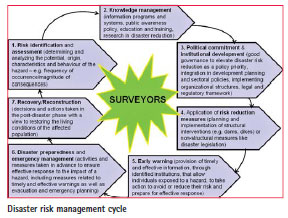
Disaster risk management is an important role of surveyor which could be effectively used to deal with climate induced disasters and Climate refugees. The core of adaptation strategy for climate refugees is disaster risk management. The contribution of the Surveying profession to disaster risk management (International Federation of Surveyors [FIG], 2006) demonstrate clearly that modern surveyors play an important role in the field of disaster risk management, although in most cases, the activities take place as part of multidisciplinary task forces. The Figure below shows that surveyors are at the centre stage of disaster risk management process. In fact, surveyors’ foot-print are always present when it comes to disaster risk management, though their contribution is neither spectacular nor in the spotlight as it is with rescue teams, policemen, doctors, etc. Nevertheless, the surveyors’ role is very substantial, but most often, unknown or misunderstood (Roberge, 2005).
It is an indisputable fact that the issue of climate refugees is greatly complex, and potentially expensive, with some countries and global organisations already overwhelmed by the demands of the 1951 conventionally-recognised refugees. However, doing nothing about the looming climate refugee problem, which could potentially cause global humanitarian disaster, is not the best option. On many occasions, the action by the global humanitarian community is either too little or too late. This often results in a cycle of poverty and vulnerability to disasters that is difficult to break. There is the need to develop an international convention on climate refugees for rectification by nations and enforced by the UN. The UN and other regional bodies like the EU, AU, ASEAN, ECOWAS and other should pursue vigorous adaptation strategy for climate refugees now, before disaster strike as the current regime is very weak and unsustainable.
Professionally, surveyors work with the land, people, political and social institutions to bring about socioeconomic development. These important professional connections occur both at local and international levels. This relationship places surveyors at a very important position to advocate and to pursue the agenda to protect and accommodate present and future victims of climate induced disasters, particularly, those living in vulnerable communities, which we are already aware are being displaced or losing their livelihood. Local surveying institutions could pursue this agenda (adaptation and protection for potential climate refugees) nationally and the FIG could also engage its partners like the UN, FAO, UN-habitat and the World Bank on the same agenda internationally. It is important to state that the issue of climate refugees is very complex and may require a huge effort and engagement of the international community. However, surveyors are used to dealing with complex problems and taking a lead role on this issue is not beyond their capacity.
References
Bates, D.C. (2002). Environmental refugees? Classifying human migrations caused by environmental change. Population and Environment, 23 (5), 465–477.
Black, R. (2001). Environmental refugees: myth or reality? (New Issues in Refugee Research, No. 34). Geneva: UNHCR.
Boano, C., Zetter, R.. & Morris, T. (2008). Environmentally displaced people: Understanding the linkages between environmental change, livelihoods and forced migration (Forced Migration Policy Briefing). Oxford: Refugee Studies Centre.
Boateng, I. (2010). Spatial planning in coastal regions: Facing the impact of climate change (FIG publication no. 55). Copenhagen: The International Federation of Surveyors.
Ehrhart, C., Thow, A., & Warhurst, A. (2009) Humanitarian implications of climate change: Mapping emerging t rends and risk hotspots (2nd ed.). S.l.: CARE International.
El-Hinnawi, E. (1985). Environmental refugees. Nairobi: UNEP.
Fritz, C. (2010). Climate change and migration: Sorting through complex issues without the hype. Washington, DC: Migration Policy Institute.
Gemenne, F. ( 2011a). Climateinduced population displacements in a 4 8C+ world.
Philosophical Transactions of the Royal Society A, 369 (1934), 182–195.
IOM, (2010). Disaster risk reduction, climate change adaptation and environmental migration, available at http://publications.iom.int/bookstore/ index.php?main_page=product_ info&cPath=41_7&products_id=664
IPCC (2013).Summary for Policymakers, AR5 to Working Group 1, available at www.ipcc.ch/report/ar5/wg1/.
IPCC, (2007). Summary for policymakers of the synthesis report of the IPCC Fourth Assessment Report. Retrieved February 27, 2012, from IPPC website: http://www.ipcc.ch/publications_ and_data/ar4/syr/en/spm.html
International Federation of Surveyors Working Group 8.4. (2006). The contribution of the surveying profession to disaster risk management (FIG Publication no. 38). Frederiksberg: The International Federation of Surveyors.
Myers, N. (2002). Environmental refugees: a growing phenomenon of the 21st century. Philosophical Transactions of the Royal Society B, 357 (1420), 609–613.
Piguet, E. (2012). From “Primitive Migration” to “Climate Refugees”: the curious fate of natural environment in migration studies, Annals of the Association of American Geographers, 103: 1,148-162
Roberge, D. (2005, April 16-21). After the Tsunami: How the surveying profession can participate in the reconstruction. Paper presented at FIG Working Week and GSDI-8 Conference in Cairo, Egypt.
Tolba, M. K. (1989). Our biological heritage under siege. Bioscience 39, 725–728.
The consensus among climate researchers and politicians has never been greater
 |
|
Fall outs of the climate change
The consensus among climate researchers and politicians has never been greater: The climate is changing worldwide. Over the past 100 years, the Earth has become a warmer place. Since the beginning of the 20th century, the global mean annual temperature has risen by 0.85 degrees Celsius (°C). The Intergovernmental Panel on Climate Change (IPCC) says there is a “very high probability” that this is due to human activities. If people continue to emit climate-relevant gases into the atmosphere without any restrictions, scientists expect mean temperatures to rise by 1.5 degrees Celsius (°C) relative to 1850 to 1900 by the end of the century.
The effects of global warming are the ecological and social changes caused by human emissions of greenhouse gases. To give one example, the 2003 European heat wave was the hottest summer on record in Europe since at least 1540. The heat wave led to health crises in several countries and combined with drought to create a crop shortfall in parts of Southern Europe. Peer reviewed analysis places the European death toll at 70,000. One of the latest natural catastrophes in Europe was the flooding in Southern and Eastern Germany and the neighboring states in May and June 2013, which gave rise to an overall loss of more than €12bn (US$ 16bn) and an insured loss in the region of €3bn plus (US$ 3.9bn). All these are crucial evidence for tackling climate change with all our strength!
Transforming the energy system in Germany
Climate change is happening now, worldwide and in Germany, too. Securing a reliable, economically viable and environmentally sound energy supply is one of the great challenges of Germany’s climate change policy. As a response to the nuclear disaster in Fukushima, in 2011 Germany adopted decisions on the gradual phase-out of nuclear power and on accelerating the energy transformation. The Federal Government adopted an energy concept which sets out Germany’s energy policy until 2050 and specifically lays down measures for the development of renewable energy sources, power grids and energy efficiency. In line with this agreement, greenhouse gas emissions are to be cut by 40% by 2020, and by at least 80% by 2050, with 1990 being the base year for both measurements.
First positive results are already visible: In electricity consumption, renewable energy sources reached a 23.5 % share in 2012 – three times higher than ten years ago. By 2020 electricity generated from renewables is to account for 35 % of gross electricity consumption. Following this, the German government will seek to increase the proportion of gross electricity consumption contributed by electricity from renewable energy sources to 80 % by 2050. What has to be recognized, too, is the economic success of the adopted measures for transforming the German energy system. Around 378,000 jobs in Germany have already been created in the renewables sector alone. To become one of the most energy-efficient and greenest economies in the world, the German government will use scientifically tested monitoring every three years to determine whether actual progress is within the corridor marked out by the development path outlined above and to what extent action needs to be taken.
Role of the surveying community
The surveyor can play a significant role, establishing, quantifying, and managing climate change. With his specialized skills in the broad fields of geodesy, he can substantially contribute to helping mitigate and adapt climate change and to reduce climaterelated risk. Requirements are not only engineering know-how but also the surveyors’ variety of skills and knowledge in geoinformatics, land management and development, building and land law, real estate and business administration as well as social competence. Primarily, geo-information is a very important decision basis for energyrelated issues: Are environmental risks such as earthquakes, floods or landslides expected in the region? In which areas is it possible to use geothermal energy? Which areas are suitable for wind power priority zones? Which roofs are suitable for the production of solar energy? What property areas are affected? How can networks be optimally adapted for the transport of energy under various requirements?
The application of modern geographic information systems and the acquisition and evaluation of geodata therefore provide an objective basis for spatial decisions related to the energy transition. For example, 3D city models enable a simulation of the spread of noise and emission or predictions of possible changes in the urban climates. In disaster situa tions, such as flooding, it is possible to evaluate, on basis of 3D landscape models quickly which areas and buildings would be affected, with the result that important supporting measures can be initiated precociously.
Surveyors acquire, evaluate and visualize geo-information as a basis for the realization of the energy transition measures in different sections such as generation, transmission, distribution, saving by solar land register, wind power priority zones or line routing. They help to predict disasters, such as floods, earthquakes, tsunamis and thus to avoid big damages. They are involved in planning and managing Smart Grids for the expansion of renewable energies. They thus make an important contribution to climate protection.
Setting priorities
Surveyors provide with their diverse and interdisciplinary competencies measurable solutions for a successful implementation of the energy transition. In my opinion, disaster risk management could (and should) be an urgent field of application for a surveyor. The wide scope of surveyor’s abilities can make an important contribution to improve, simplify and shorten the risk management process related to global climate changes:
• Surveyors monitor local, regional and global changes of the earth with the help of modern satellite technology, digital remote sensing sensors or automated instruments such as tachymeter.
• Surveyors gather, assess and visualize geoinformation in order to provide the fundamentals for decisions on the implementation of measures in the transitional process towards green energy in the fields of energy generation, transport, distribution and economisation by means of solar cadastres, wind power priority zones or routing.
• Surveyors assist in forecasting natural disasters such as floods or tsunamis and thus in preventing substantial damage. They participate in the planning and management of smart grids for the expansion of renewable energy, thereby making an important contribution to climate protection.
• Surveyors use virtual 3D models of towns, buildings and landscape for an easier location in case of a disaster (evacuation and emergency planning). They supply digital maps for emergency planning and mobile mapping.
To contribute to a more sustainable and effective disaster risk management, International Federation of Surveyors (FIG) implemented a Task Force on Surveyors and the Climate Change to highlight the current and future need for research and action in the field of climate change governance, adaptation and mitigation.
Priorities are the inclusion of the whole climate change debate in surveying profession
 |
|
 |
|
Fall outs of the climate change
There are many people sceptical about climate change and its effects. Although we -as land surveyors- cannot always value and judge the scientific reports about climate change, we feel three aspects are generally accepted and not much under debate. Firstly, it is unequivocal that the climate system is warming. The reason is the increasing emission of greenhouse gases. Evidence is strong that emissions are mainly humanly induced. A logical policy measure is then to reduce emissions. Secondly, different from other sector like energy, the process of photosynthesis in biomass provides an opportunity to also remove greenhouse gases from the atmosphere. The logical policy measure is then to increase biomass. Thirdly, various scenario’s show the impact of climate change on urban and rural areas, specifically in the coastal zones. These include a likely increase in the incidence and severity of natural disasters. Socially, vulnerable groups of people are under pressure, because of their location and lack of funds to protect themselves. A logical policy measure is to prepare for disasters, with extra attention for the poor. We see this as the framework for our contribution to the FIG Task Force on Climate Change.
Linkages between climate change and land use changes
Conceptually the link is that humanly induced emission of greenhouse gases relates to the organisation of our lives, especially the spatial component of it: the way we build cities and settlements, the need for transportation, heating and cooling, our consumption pattern and the way we deal with land, resulting in degradation and deforestation. The second aspect, the removal, requires enough biomass to convert CO2 into oxygen. Carbon pools are in oceans and in the earth’s crust, but also in tree biomass, vegetation, roots, forest litter, dead wood, and soil. Increasing carbon sequestration is key. The third aspect, preparing for disasters, always has had a spatial component, simply because it concerns the protection of people at the place they live. Now the point is that many policy measures to tackle our three aspects, include land use planning and land tenure security. Good land use planning creates cities that are more compact, with less transportation and less need for heating and cooling, to name a few measures. Good land use planning also creates a rural area that enriches soil carbon, produces perennials instead of annual tilled crops, reduces livestock production, protects natural habitats such as forests, and restores degraded watersheds and rangeland, again to name a few. There is also awareness that governments cannot do this alone. The private sector and citizens have a duty to adopt sustainability in their housing and agriculture. But how to ask investments from land owners and users, when they suffer tenure insecurity? This is even more a problem when it comes to vulnerable people in -for example- coastal zones. Land delivery, resettlement planning, good use of public lands, are here all related to land use. In our contribution we add to these concepts statistical figures for evidence.
Role for land surveyors in the carbon credit market
It is a bit too early to strongly confirm that land surveyors have a role to play. What is the case? We see two markets developing. In the first place the ‘compliance market’, established by articles 6, 12 and 17 of the Kyoto Protocol. The Protocol aims at reducing the emission of greenhouse gases through a ‘cap and trade system’. It works roughly as follows. Countries are assigned emission units, in line with their reduction commitments. Countries that have emission units to spare can sell their surplus to countries that are over their targets. Articles 3.3 and 3.4 of the Kyoto Protocol says that also the creation of greenhouse sinks in soils and vegetation can be used to fulfill a country’s obligation. When done successfully, they can thus trade their gained surplus emission units. A similar situation exists when countries work together (for example to invest in re-forestation) and earn credits. A well know market is the European Emission Trading System. The value in 2011 of the global market amounted to US$176 billion, representing an emission volume of 10 Gtons of CO2e. Currently the price has collapsed, because the financial crisis changed the supply-demand relationship. The compliance market under Kyoto is a strictly regulated market.
Outside the Kyoto Protocol and different from the compliance market, a retail offset market has emerged, with a focus on voluntary participation by parties not bound by specific caps or regulations. Greenhouse gas emissions can be offset by investing in projects that provide emission reductions in the form of Voluntary Emission Reduction Units. Projects -for example- include voluntary reforestation, grazing land management, cropland management, and re-vegetation. In Australia farmers are encouraged to pursue ‘carbon farming’. Critically, the voluntary market is still unregulated in that it has no market standards, although improvements are made (such as a recent ISO standard). However, still fraud occurs, money laundering takes place, which is the reason why the UK House of Commons earlier urged for regulation of the what they call the ‘carbon cowboys’.
Within FIG, Prof. Grenville Barnes already assumed that for a fair trade in carbon credits 5 fundamental questions should be answered, namely what rights, whose rights, when were they acquired and what is the duration, how were they acquired, and what are the spatial dimensions (location, extent, boundary dimensions). Barnes urged for a carbon cadaster. That looks similar to a property right, isn’t it? So the question is whether voluntary carbon reduction units are property or not? We refer to a FIG publication of Dr. Jude Wallace, who sees carbon credits as one of the complex commodities in the property market, in the form of an unbundled property right, comparable with –say- a mineral right or an encumbrance.
However, whether an emission right creates a property right is yet not clear. Apparently, an emission right knows exclusivity, has value, can be traded. A UK Court considered emission rights therefore as a property right as do the International Accounting Standards Board and the US Congress. The Australian Securities and Investment Act 2001 however maintains that a carbon credit is just a financial product. In our contribution to the FIG report we see the following links with the work of land surveyors.
In the compliance market carbon sequestration by biomass requires land surveyors’ involvement in land policy, land management and land administration as said earlier. Secondly, in the case voluntary carbon credits are considered to be an ‘unbundled’ property right, with a separated carbon credit title, land administration systems should be able to record or register such rights, to attach appropriate geometric attributes and to make those titles accessible for trade in the carbon credit market. Thirdly, the volume of the carbon credit needs to be estimated, which is called ‘carbon accounting’. There is a widespread demand for a well-designed carbon accounting system. The methods used for calculating carbon credits demonstrate a remarkable similarity to the work of quantity surveyors, whose profession it is to survey land areas and volumes to estimate building and construction costs. Here might be a chance, even more because widely there appears to be dissatisfaction with the current methods.
Role of the surveying community
We believe land surveyors are key professionals in the domains of land policy, land management and land administration. Being aware that many climate measures are land use–related, land surveyors must contribute to reshaping conventional policy and implementation measures into climate proof measures. In the FIG report we are more specific. We expect land surveyors to be part of multi-disciplinary teams of experts. Overseeing the international literature, we think this work concentrates on urban areas, rural areas, forests and coastal zones, each with addition of their local context. Of course, we focus here on the land use aspects in our domain only. For example geodetic aspects of monitoring climate change is also an important part of our profession, but outside our assignment for the FIG Task Force. Colleagues take care of this part in the report.
Priorities and challenges
We believe priorities are the inclusion of the whole climate change debate in our profession and the adoption of the urgency of climate change measures in our thinking. Are our current approaches to for example land management and land administration, sufficiently serving the needs of governments and communities for low cost methods of land surveying and quick ways of land registration, addressing a variety of land tenures? The fit-forpurpose discussion within FIG is from this viewpoint ‘just in time’.


 (347 votes, average: 1.03 out of 5)


Leave your response!