| LBS | |
Using Assisted-GNSS to locate handsets in wireless networks
|
||||
|
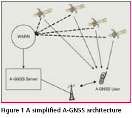
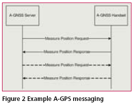
There are many different types of technologies employed in calculating the location of handsets in wireless networks with various levels of success and accuracy. Assisted-GPS (A-GPS) is a positioning technology that is presently used for locating handsets in wireless networks and is gaining traction in the market. An A-GPS server provides assistance data to the handset in order for it to have a low Time to First Fix (TTFF), weak signal acquisition and optimize handset battery use. A-GPS is used as a location technology in isolation or hybridized with other positioning technologies that provide range-like measurements. In this paper positioning and standards for A-GPS in wireless networks is discussed along with some results of simulations of Hybrid A-GPS positioning. An A-GPS server provides data to a wireless handset that is specific to the approximate location of a handset. The assistance data helps the handset lock onto satellites quickly and also potentially allows the handset to lock onto weak signals. The handset then performs the position calculation or optionally returns the measured code phases to the server to do the calculation. The A-GPS server can make use of additional information such as round-trip timing measurements from the cellular base station to the handset in order to calculate a location where it may otherwise not be possible, for example when there are not enough GPS satellites visible. Assisted Global Navigation Satellite System (A-GNSS) extends the concept to other satellite navigation systems besides GPS. There could be 80 GNSS satellites orbiting the planet within 10 years, all transmitting a variety of signals. This includes GPS, GLONASS, Galileo and other satellites. This will give a receiver access to many more satellites which will improve both accuracy and yield. More satellites means that position accuracy is less susceptible to satellite geometry and also provides greater redundancy when doing the position calculation. A simplified A-GNSS architecture is shown in Figure 1. A Wide Area Reference Network (WARN) is a network of GNSS receivers that are placed geographically over the coverage area of the wireless network. The WARN collects the broadcast navigation message from the GNSS satellites and provides it to the AGNSS Server for caching. An AGNSS User makes an emergency call or a service is invoked that requires location and a message is sent to the A-GNSS Server. The A-GNSS server calculates the GNSS assistance data required using the location of the radio access tower as the approximate location and provides it to the handset. ApplicationsA-GNSS is useful for determining the location of cellular phones in an emergency situation and also for location based services. Deployment of A-GPS in the United States is the result of the Federal Communications Commissions’ (FCC) Enhanced 9- 1-1 mandate. That mandate requires that for network-based solutions: 100 meters accuracy for 67 percent of calls, 300 meters accuracy for 95 percent of calls; for handset-based solutions: 50 meters for 67 percent of calls, 150 meters for 95 percent of calls [1]. When an emergency call is initiated, an emergency services coordination centre – Public Safety Answering Point (PSAP) will make use of the location that is calculated in the MLC. In Europe and Asia deployment is being driven by Location Based Services (LBS), though requirements for emergency service cellular location have been or are being established in these regions. StandardsThe different components of an AGPS server are defined in J-STD- 036 [2]. As a real-world example, the Andrew Corporation Geometrix Mobile Location Center (MLC) product supports A-GPS functionality. The MLC is deployed as part of a wireless network and its purpose is to determine the location of handsets within the network. The MLC runs in GSM/GPRS and UMTS networks and can act as a Serving Mobile Location Center (SMLC), Gateway Mobile Location Center (GMLC), Standalone AGPS SMLC (SAS) or SUPL Location Platform (SLP) and various combinations of these. The MLC supports all handsetbased and network-based wireless location methods, including AGPS in both handset-based and handset-assisted versions. There are several different standards for the A-GPS messaging with the handsets. For GSM networks RRLP [3], UMTS networks RRC [4] and CDMA networks PDDM [5] and [6]. These protocols are different ways of encoding the same basic information but are specific to the radio technology. The Secure User Plane Location (SUPL) architecture [7] is defined by the Open Mobile Alliance (OMA) and allows bypass of many of the traditional telecommunication elements to be bypassed by relying on SUPL functionality within the target device. This makes network interoperability simpler and is a platform that is likely to get wide acceptance as the requirement to also support legacy, non-location capable, devices diminishes. The SUPL Enabled Terminal (SET) makes a secure TCP/ IP connection directly with the SUPL Location Platform (SLP). The SET and the SLP exchange messages using the UserPlane Location Protocol (ULP) [8] which is the transport for the underlying RRLP messaging. ULP optionally supports RRC [4] and the CDMA PDDM standards [5] and [6]. Operators are starting to deploy SLPs and quite a few handset manufacturers offer SETs. Present standards cater for GPS L1 C/A code assistance data. There are two Global Navigation Satellite Systems (GNSS) presently in service; GPS and GLONASS. The European Galileo project is also underway and will meet Full Operational Capacity (FOC) within several years. The SUPL specification facilitates Assisted-GNSS (A-GNSS) operation but the underlying RRLP, RRC and PDDM protocols do not currently support it. This is presently being worked by the standards bodies. Once the A-GNSS mechanism has been defined for these protocols, an A-GNSS server will be able to provide assistance data to different types of handsets (for example a Galileo handset Assisted- Galileo) and handsets that have receivers capable of detecting satellites from multiple GNSSs (for example a combined GPS and Galileo receiver). Standards are also being developed for providing location in Voice over Internet Protocol (VoIP) networks. VoIP allows users to make telephone calls over the IP network instead of switched circuit network. Some VoIP providers presently do not even provide access to emergency services such as 9-1-1 in the USA. The National Emergency Number Association (NENA) and Internet Engineering Task Force (IETF) are developing the architecture and standards for delivery of the location within VoIP. It is likely that the handset will talk to the Location Information Server (LIS) via a protocol that will encapsulate RRLP or some derivative messaging at its deepest layer. Handset-based A-GPS and Handset-assisted A-GPSThere are two primary modes of operation for A-GPS. In handsetbased A-GPS mode, the handset requests assistance data from the AGPS server which is used to lock onto the satellites in view and calculate the position of the handset. In handsetassisted A-GPS, the handset requests assistance data from the A-GPS server which it uses to lock onto the GPS satellites. It then sends the GPS measurements to the A-GPS server for it to do the position calculation. An example of messaging between an A-GNSS server and handset is shown in Figure 2. The messaging shown is one way that RRLP is used to achieve GNSS positioning of the handset. A location request could be network-initiated in the case of a Location-Based Application (LBA) providing a value-added service. It could also be handset-initiated in the case of the user making an emergency call or an application running from the handset itself. When the location request is received at the A-GNSS Server, it sends a Measure Position Request message to the handset. If the handset has sufficient cached GNSS assistance data then, in the case of handset-based GPS, the handset will lock onto the satellites, perform the position calculation and return the location in the Measure Position Response message. In the case of handset-assisted GNSS the handset will lock onto the satellites and return the satellite measurements to the server to do the position calculation. Generally however, the A-GNSS Handset will not have sufficient assistance data and will send a Measure Position Response to the A-GNSS Server with the assistance data types that it requires. The A-GNSS Server will then send another Measure Position Request to the handset with the requested assistance data types. In the case of handset-based A-GNSS, the primary assistance data type is the navigation model (which contains the ephemeris). The handset uses the information in the ephemeris to calculate where the satellites are in order to refine its search and also as input to its position calculation. In the case of handset-assisted AGNSS, the primary data type is the much more compact Acquisition Assistance data type. The Acquisition Assistance data tells the handset which satellites to search for and provides a search window in the time and frequency domain for each satellite. The handset treats the search windows as relative search windows once it locks onto the first satellite. In this mode, the handset has no need to calculate where the satellites are since it is not doing a position calculation, instead it returns the GPS measurements to the A-GNSS server in the Measure Position Response. The measurement consists of the approximate time, the code-phase chip measurements, Doppler, RMS error of the measurements, and a multipath indicator. The server can then do a self-contained position calculation or make use of additional measurements and perform a hybrid location. |
||||
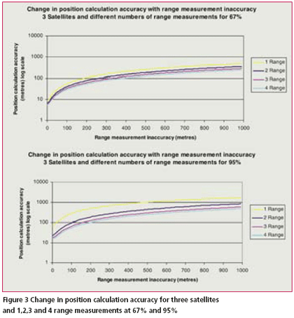
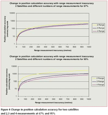
Hybrid A-GNSSThere are several advantages of performing the position calculation on the server (handset-assisted AGNSS) [9]. One of the advantages is that there is opportunity to include additional range measurements that the server can obtain from the network into the position calculation. This can improve both the yield and accuracy of the location solution. When the handset is in an area where its view of the sky is obscured it may not be able to lock onto the minimum number of satellites to perform a position calculation. In this case the other range measurements may permit a position to be calculated when otherwise there would be none. In the case where there is more than the minimum number of satellites in view, additional measurements provide increased measurement redundancy and hence improve yield and accuracy by making the position calculation less susceptible to bad measurements. The accuracy of range measurements depends on the radio technology and their sources. Range measurements are generally either calculated from signal strengths measured from a known source in combination with a propagation model, or are determined from timing measurements associated with known signals arriving from a known source They could be Timing Advance (TA) in a GSM network, Uplink Time Difference of Arrival (UTDOA) time difference measurements, WiFi or Digital TV (DTV) ranging signals. When incorporating these range measurements into the position calculation algorithm, the accuracy of the measurement needs to be considered so that it doesn’t make the location worse. Some results of position calculation accuracy with simulated range measurements are shown in Figure 3 and Figure 4. Here the case where there are not enough satellite measurements to do a complete GPS solution is considered. GPS data was collected over a complete day from a GPS receiver on the roof of the laboratory and consists of 80,657 distinct epochs. In order to simulate a situation where only three satellites are in view (which is the case in Figure 3), three satellites are randomly selected from each epoch and range measurements are introduced with varying levels of inaccuracy. These simulated range measurements show how the accuracy of the overall position calculation is influenced by errors in the range measurements across a whole day of GPS data. The position calculation function used for experiments is a parametric weighted least squares implementation where range measurements are considered as another input to the solution with appropriate weighting in the stochastic model. Figure 3 shows the effect of the error in the position calculation when there are only three satellites in view of the receiver and there are different numbers of simulated range measurements of varying inaccuracies. It shows that when there are only 3 satellites and 1 accurate range measurement there is less than 10 metres of error over a complete day of data for 67% of the data and just over 10 for 95%. As the inaccuracy of the range measurement increases the distance of the calculated location from the ground truth increases. For example, GSM TA has accuracy in the vicinity of 550 metres. So that would result in a position accuracy of over 100m at the 67% level. Similarly, Figure 4 shows the results of using only two satellites and 2,3 and 4 range measurements. In this case the position accuracy follows a similar curve and the accuracy of the location is highly dependant on the accuracy of the range measurements. ConclusionWireless standards for A-GPS are mature and are in general use. SUPL positioning bypasses traditional telecommunications and allows a handset to talk directly with the SLP. This makes network interoperability simpler and is a platform that is likely to get wide acceptance. Standards bodies are presently considering the integration of GNSS information in order to facilitate use of the other GNSSs. This will lead to more satellites being available to the handset and an improved yield and accuracy for the position calculation. Hybrid A-GNSS is a viable solution for improving yield when there are not suffi cient satellites visible. The accuracy of the resulting location depends on the accuracy of the additional range measurements and how they are integrated into the position calculation function. It is equally applicable to control plane or user plane location architectures. References[1] Federal Communications Commission (FCC) OET Bulletin 71, Guidelines for Testing and Verifying the Accuracy of Wireless E911 Location Systems, April 12th 2000 [2] TR-45 Enhanced Wireless PN- 3890-RV2 9-1-1 Phase II J-STD-036 [3] 3GPP TS 44.031, “Location Services (LCS); Mobile Station (MS) – Serving Mobile Location Centre (SMLC) Radio Resource LCS Protocol (RRLP)”, URL: http://www.3gpp.org/ [4] 3GPP TS 25.331, “Radio Resource Control (RRC) Protocol Specifi cation” URL: http://www.3gpp.org/ [5] 3GPP2 C.S0022-0 v3.0, Position Determination Service for cdma2000 Spread Spectrum Systems; April 2001 [6] 3GPP2 C.S0022-A v1.0: “Position Determination Service Standard for Dual Mode Spread Spectrum Systems” March 2004 URL: http://www.3gpp.org/ [7] OMA Secure User Plane Location (SUPL) Architecture [8] OMA UserPlane Location Protocol (ULP) [9] Harper, N., Nicholson, P., Mumford, P., Poon, E., 2004, Process for improving GPS acquisition assistance data and server-side location determination for cellular networks,Journal of Global Positioning Systems, Vol 3., No. 1-2, 2004 http:// www.cpgps.org/journals.php |
||||||||||||
|
Pages: 1 2


 (No Ratings Yet)


