| Applications | |
Transport planning in Korea
Establishment of nation-wide transportation infrastructure with GNSS technology would facilitate development of the next-generation growth engines in areas of telematics and intelligent cars |
|
During the last half century, countries all over the world went through a remarkable economic growth, which resulted in higher income levels and changes in people’s way of living. In particular, transportation industry has undergone a dramatic change. The number of privately owned cars has explosively increased to facilitate individuals’ travel. Volume of goods transportation also rose sharply due to expanding global trade and online commerce. Increasing volume of traffic has led to chronic traffic congestion, environmental pollution and traffic accidents, which means higher social and economic cost, as well as loss of life and goods. Countries with advanced transportation system such as the U.S, E.U and Japan are responding to rising traffic demands through efficient management of traffic systems, by expanding traffic facilities and utilizing information technology. These countries have long used Global Navigation Satellite System (GNSS) which is widely used to enhance safety and efficiency of transportation by providing position information of vehicles. GNSS is used not only to determine vehicles position but to charge toll fees and gather information on goods transfer, and so on.
Recently, there is a rising demand to develop a nation-wide infrastructure technology in order to address transportation issues in eco-friendly, low-cost manner, and to enhance safety and efficiency of transportation. Rapid advancement of IT brought about Intelligent Transportation System, leading to real-time traffic information. In future, it is expected that the land transportation system would use even finer control methods, and to do so, it is necessary to improve accuracy and reliability of position information. This, in turn, calls for an upgraded infrastructure to provide position information. Currently, there are many technologies that are available to gather position information for land transportation, but their use is limited due to technical issues or high price. To overcome these issues, studies are being conducted on GNSS. Noting this trend, Korea Aerospace Research Institute (KARI) are also working on the project “Development of GNSS-based transportation infrastructure technology” to respond to future transportation system and to expand the use of GNSS for land transportation.
Necessity of research
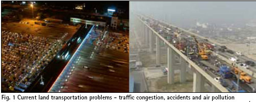
With rapid increase in land transportation volume and diversified transportation systems, related problems are getting more complicated in terms of traffic congestion, accidents and air pollution (Fig. 1).
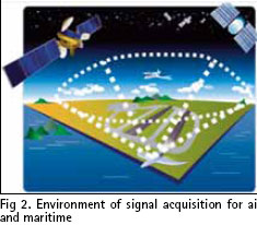
Many endeavors are being made to address these issues in an environment-friendly way and at a low cost. In particular, use of GNSS is taking off, and there is a rising demand to develop a new infrastructure to optimize use of GNSS for land transportation. Use of GNSS has been extensively studied for air and maritime transportation, which have a relatively favorable environment to receive signals from GNSS (Fig. 2).
In both areas, agencies like International Civil Aviation Organization (ICAO) and International Maritime Organization (IMO) are actively undertaking research to drive performance requirements of navigation systems. The drive for navigation performance requirement of land transportation is less active. Because the transportation environment is different, a system for land transportation cannot adopt performance requirement of GNSS estimated for air and maritime transportation. For instance, many obstacles such as high-rise buildings, overpasses and large signboards make it hard to receive signal from GNSS, unlike in the air or at sea. As a result, it is extremely difficult to set a performance requirement depending on operating mode of a vehicle (Fig. 3).
Necessary technology
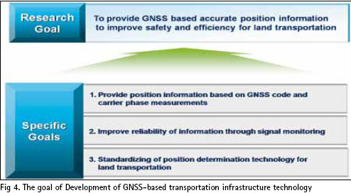
Currently, use of GNSS is mostly limited to notifying user’s position on the road; it does not ensure reliability of the information. In order to improve user’s security and efficiency, road information needs to be more reliable. Thus, in developing GNSS-based transportation infrastructure, the goal is to provide accurate position information to improve safety and efficiency of the system, at a designated position-exterminating point, for land transportation. Figure 4 lists detailed goals in developing technologies to provide position information based on GNSS code and carrier phase measurements, improve reliability of information through signal monitoring and to standardize GNSS based transportation infrastructures.
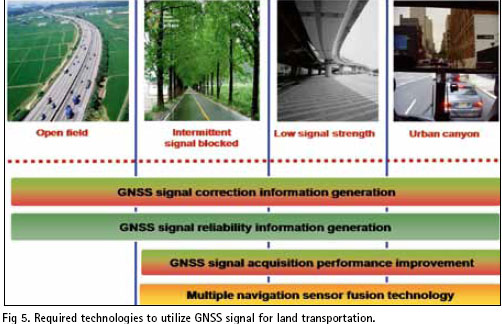
Technologies used to develop GNSS-based infrastructure include infrastructure system design, generation of error correction information, generation of integrity information, GNSS signal acquisition performance improvement, multiple navigation sensor fusion. Figure 5 illustrates technologies required to utilize GNSS signal for land transportation.
Infrastructure design technology indicates system configuration to build GNSS-based transportation infrastructure system. Korean companies have little experience in designing infrastructure system and are heavily dependent on foreign technology. It is important to develop technology to design an independent system. Generation of error correction information means processing and providing error elements to remove signal error in GNSS. Code measurements-based information correction technology has reached a level to enable real-time operation, but carrier phase measurements-based technology is lagging behind. Generation of integrity information indicates a technology to process and provide information to alarm users with risk of the location information. Studies are under way for simple algorithm to generate integrated information, but empirical test on technology of detecting anomaly of true ionospheric layer is non-existent. GNSS signal acquisition performance improvement means developing adoptive technology under weak signal. Multiple navigation sensor fusion technology of low-cost sensors (IMU, DR, visual sensor) and GNSS satellite signals to determine a user position. Sensor coefficients (code-based, GPS/INS/ DMI-based) and convergence technologies are in place. However, carrier phase measurement -based multiple navigation technology is still in a nascent stage of exploration and algorithms development.
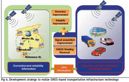
In order to determine position using GNSS for land transportation, Technologies for user are required in addition to infrastructure technology. Figure 6 describes development strategy to realize
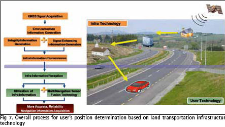
“Development of GNSS-based transportation infrastructure technology” A system configuration to build GNSS-based land transportation infrastructure roughly consists of satellite navigation signal sensor station, central processing station, and users. Additionally, signal transmission is needed to transfer correction, integrity and assistance of information between central processing station and users. The signal sensor station collects signals from the satellite, and provides the central processing station with information received, tracked and collected. The central processing station processes necessary information using raw data from the sensor station. To use the service, a user needs a device equipped with technologies to utilize corrected, integrity information. The signal sensor station gathers data, and the central processing station processes the data to generate corrected, integrity, and signal-enhancing information to deliver to the users. Finally, a user determines its own position. Figure 7 illustrates an overall process of user’s position determination based on land transportation infrastructure technology.
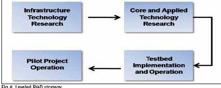
“Development of GNSS-based transportation infrastructure technology” can be divided into four stages: research on basic technology, study of core and applied technology, preparation for operation of test bed, and pilot project (Fig. 8).
In the first stage, technology intensive studies are performed in regard to generation of corrected, integrated information. Also, technologies—whose applicability can be verified—are developed for land transportation areas with relatively good visibility, excluding system aspects such as communication delay. In the next stage, in-depth research is conducted for the technologies explored in the previous stage. This includes establishment of small-scale experiment environment and test evaluation. Core technology refers to technologies that can yield a certain level of outcomes through R&D, based on basic technologies. Core technology cannot be produced in a short period of time. Applied technology indicates technologies required to apply basic and core technologies to an actual system. In the stage of building and operating a test bed, all three levels of basic, core and applied technologies are tested in actual operating environment, and checklist is inspected. A test bed means testing environment to decide how to configure an actual system in applying basic, core and applied technologies. A pilot project is implemented to analyze feasibility of the system, before establishing infrastructure all over the country. However, pilot project is beyond the scope of this research project.
Conclusions
The new GNSS-based transportation infrastructure can produce more accurate and reliable position information, to improve efficiency and safety, and can play a major role in future land transportation realizations such as Smart Highway, Ubiquitous Transportation and goods tracking. During the development process, various algorithms are explored, which will help advance related technology and secure technical advantage in the use of GNSS for land transportation. Unlike the use of GNSS for maritime or air transportation, its application to land transportation poses several limitations such as lower visibility and multi-paths stemming from ground obstacles. Overcoming these obstacles will lead to advantageous position in the related field. By standardizing new technology, Korea can secure a favorable status in the global market. Establishment of nation-wide transportation infrastructure with GNSS technology would facilitate development of the next-generation growth engines in areas of telematics and intelligent cars, creating a high-value market segment. In particular, new markets will emerge for installation of reference stations and production of user devices. An upgraded device will be able to provide new services such as vehicle operation record, or accident analysis, based on more accurate and reliable position information. This will lower risk of traffic accidents, eventually cutting back social cost through efficient transportation. In this research, current issues in developing GNSS-based land transportation infrastructure were examined, as a response to an emerging transportation system of tomorrow, and to improve safety and efficiency of land transportation. By standardizing related technologies, Korea will be able to acquire valuable core technologies in the global market, and also create new business markets.
Acknowledgement
This work was supported by the Development of GNSS based Transportation Infrastructure Technology through a funding by the Ministry of Land, Transportation and Maritime (MLTM) Affairs.
References
21 Century Transportation Policy Innovation Project, Korea Transport Institute, 2003
ITS, Korea Institute of Science and Technology Information, 2003
Development of Future National Transportation Information Collection Systems and Pilot Project in the Ubiquitous Environment, KT Corporation, 2007
New Transportation Policies for National Competitiveness Improvement, Korea Transport Institute, 2007
Direction and Implication of Advanced Countries Transportation Policy, KRIHS Policy Brief Vol. 179, 2008
USN based Telematics Service Technology, Electronics and Telecommunication Research Institute, 2008
Development of GNSS based Transportation Infrastructure Technology, Ministry of Land, Transportation and Maritime Affairs, 2009
 |
|
|||||
 |
|
|||||
 |
|
|||||
 |
|
|||||
 |
|
|||||
My Coordinates |
EDITORIAL |
|
His Coordinates |
Sanjai Kohli |
|
News |
INDUSTRY | GPS | GALILEO UPDATE | LBS | GIS | REMOTE SENSING |
|
Mark your calendar |
AUGUST 2010 TO NOVEMBER 2011 |




 (No Ratings Yet)


Leave your response!