| Geodesy | |
The Potential of VSOP2
|
WEI ERHU, LIU JINGNAN, YAN WEI
|
||||||||||||||||||||||||||||||||
|
SVLBI (Space Very Long Baseline Interferometry) is an extension of the ground-based VLBI into the space. It has some important potential applications in geodesy and geodynamics, including the definition, practical realization, and the interconnection of different reference frames, determining the geocentric positions of VLBI stations, estimation of the gravity field of the Earth, and satellite orbit determination using the delay and delay rate observables. The idea of SVLBI was brought forward by N, S. Kardashev in 1970s. More deeper research had been done in 1970s and 1980s. With the launching of the first SVLBI satellite of the VLBI Space Observatory Programme (VSOP) of Japan, in February 1997, this technique has become a reality. An international team of scientists, working under the auspices of the FÖMI Satellite Geodesy Observatory, Hungary, has designed the Geodesy Demonstration Experiment (GEDEX), for the purpose of exploring the feasibility of the geodetic applications of SVLBI. However, several major problems also exist. It is not suitable for geodetic and geodynamic study, which requires precise tracking capabilities resulting in cm orbit accuracy. But the precision of orbit determination is within 10 meters. It is not suitable to frequently changing observing objects. So it cannot provide observations aiming at more radio sources, which are required for geodetic and geodynamical studies. On the other hand, the satellite stopped transmitting observation data after October 2003 and terminated its work on 02:28UT November 11th 2005. Introduction of VSOP2The ProjectFollowing the success of the VSOP, a next generation space VLBI mission, currently called VSOP-2, is being planned in Japan with international collaboration for a launch as early as 2012. Although there are some obvious defects in VSOP, it is more preponderant than ground-based VLBI. For example, it can provide radio observation with a baseline length longer than the diameter of the Earth to increase observation resolution; also, it can provide all-day VLBI imaging; It has the ability of quick-imaging by the fast movement of VSOP surrounding the Earth; Observation of microscale characteristic is provided by the reduction of u – v empty and so on (SHEN Zhiqiang, 1998). VSOP can achieve more difficult researches with these advantages, such as revealing the fine structures of active galactic nuclei (AGNs). VSOP has achieved its preconcerted mission requirement and has obtained some successes after several years, including: the quick-change of radio source in 1 day can be observed by quick-imaging; north-south resolution is increased obviously; increasing the dynamic range of image (WAN Tongshan, 1999). So VSOP has promoted the development of SVLBI. Based on the successes of VSOP, the science goals for the VSOP-2 mission will place the emphasis on observations in the millimeter wave-band, enabling imaging on the scale of the accretion disk and jet acceleration region surrounding the supermassive black holes in the center of active galactic nuclei, and allow the structure of protostellar magnetospheres to be clarified. Because of the improvement of satellite orbit and structure, such as large deployable reflector (LDR), VSOP2 is more efficient than its precursor. These improvements include: ten times higher observing frequency; ten times better resolution; ten times higher sensitivity; astrometric capability and further sensitivity gains from phase referencing; Measurement of magnetic fields through dual polarization observations and so on.
Satellite orbit parametersAs the next generation of VSOP, VSOP2 makes progress in many aspects. According to VSOP-2 Proposal Abridged English Version, the satellite orbit parameters of VSOP2, such as apogee height and perigee height, are appropriately adjusted by studying the influence of high angular resolution and orbit period caused by high apogee height, the influence of atmospheric resistance near perigee and so on. The adjustment makes VSOP2 more suitable for science researches. The comparison of VSOP and VSOP2 parameters is listed in Table 1. In the following, simulation analyses will be made. Requirements for Orbit DeterminationThe simulation of VSOP2 in this paper includes: Orbit Determination (OD) of VSOP2 satellite by GNSS, the tracking status of the satellite and the feasibility of connecting observation between the satellite and the observation stations on the ground. |
||||||||||||||||||||||||||||||||
|
WEI ERHU, LIU JINGNAN, YAN WEI |
|||||||||||||||
Orbit determination accuracy requirementsIn the report prepared by the RADIOASTRON Navigation Astrometry and Geodesy (NAG) Working Group about the precise navigation of the SVLBI satellite, the following orbit determination accuracy requirements have been specified (NAG, 1989): Required accuracy better than 0.1m for geodynamic applications. As reported (ISAS, 2003), the satellite in relatively low Earth orbit can achieve 5 cm level OD with GPS and accelerometer. But there is no signal from GPS near VSOP apogee. Using GALILEO system as a supplement of GPS is a best way to improve OD. Pre-literature has been discussed the coverage instance of SVLBI satellite by GPS and GALILEO system (WEI Erhu, 2006). As some papers (IAIN/GNSS 2006) have studied, it will be possible to use GPS and GALILEO as one system. In this paper, the OD accuracy of VSOP2 by above situation is discussed. Simulation StudySimulation ConditionGALILEO constellation in simulation is composed of 27 satellites. They spread equably in 3 orbits whose inclination is 56°. The satellite’s altitude is 23062 km and orbit period is 14.0 hs. The ratio of coverage of VSOP2 near apogee, which is advantaged for OD, will be improved because of higher altitude of GALILEO. The parameters of GPS are from NASA website (ftp://cddis.gsfc.nasa.gov/gps/data/daily/2005/). There are 24 satellites in the simulation. On the other hand, considering the antenna is not globose to receive signal from all directions, and the influence of ionosphere and troposphere, the antenna is designed to point to space. It is designed as a cone with an apex angle of 80° to let the satellite to receive as more signals as possible. The coverage instance of VSOP2 by GPS and GALILEO system and its DOPs (PDOP which will be chose the best 6 satellites to calculate is mainly considered) is analyzed to achieve high accuracy OD. VSOP’s Simulant conclusion in the same time is compared. Results of SimulationThere is not enough number of satellites to calculate the coverage time and PDOP during the simulation because of the design of the antenna. For example, the coverage near the apogee is too bad for OD. The coverage instance of VSOP and VSOP2 by GPS and GALILEO system is shown in Table 2. According to the Table above, VSOP2’s coverage time by GNSS is shorter than VSOP in the simulation because its apogee height is higher. But during the natural tracking time, VSOP2’s mean PDOP is appreciably smaller than VSOP. And VSOP2’s PDOP is steadier than VSOP by analyzing their max and min PDOPs. That means the geometric structure of VSOP2 and GNSS system is better. It ascribes to the superiority of VSOP2’s orbit design. As reported (ISAS, 2003), because of the combination of GPS and GALILEO system, the mean square error of OD accuracy can achieve 3 cm, so the actual OD accuracy can achieve 0.073 m by calculating with the mean PDOP—2.454. During the simulation, the time which OD accuracy under 1 m accounts for total time 100%, excluding the epoch which doesn’t satisfy the OD requirement. The OD accuracy of VSOP2 and VSOP by GNSS is shown in Fig 2. This conclusion is suitable for geodetic and geodynamic studies.
ImprovementAlthough PDOP for VSOP2 is better in the simulation, coverage time is an important factor in OD. So if the pointing of GNSS antenna can be set to more directions, the OD accuracy will be better. For example, if another GNSS antenna points to the Earth and its apex angle is also 80°, the percentage of coverage time will increase to 100%. Its mean PDOP is 4.196. But the influence of atmosphere in this kind of situation should be considered. The details are shown in Table 3 and Fig 3 The simulation above shows that VSOP2’s OD accuracy is suitable for geodetic applications by using GNSS system. |
|||||||||||||||
|
WEI ERHU, LIU JINGNAN, YAN WEI |
||||||||||||||||||||||||||||||||||
Results and analysesObserving time is the guarantee of baseline observation. In the simulation, the observing time of HR-7745 by VSOP2 satellite is 79501.476 seconds, accounts for 92.02% of the simulation time. The observing time and proportion of each telescope is: Beijing, 11148.078 seconds,12.90% Shanghai, 23077.354 seconds, 26.71% Guizhou, 27132.087 seconds, 31.42% Kunming, 28297.055 seconds, 32.75% Urumqi, 0 seconds, 0%. The observing time of radio telescopes in China is decreased by the increasing latitude and longitude. Especially for Urumqi radio telescope, it can’t undertake the mission of tacking radio source in south sky. According to the observing time, there are the most 4 baselines can be formed from 1 Jun 2008 18:18:27.371 to1 Jun 2008 19:55:06.457. The observing time is 5771 seconds and accounts for 6.68% of the simulation time. The observing time and proportion of different number of baselines is listed in Table 4.
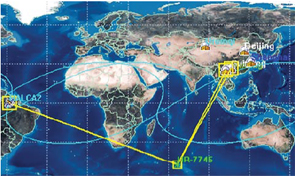
According to the results above, three observation stations’ observing time which can form baselines with the satellite is more than an orbit period in the simulation, excluding radio telescopes in Beijing and Urumqi. The observing time is long enough for observation. In the simulation, Kunming and Guizhou can form baseline with VSOP2 satellite when it is in the apogee (it is shown in Fig 6 in which VSOP2 and HR-7745 are both projection of Sub-satellite point). So the length of baseline can be longer than 31000 km. The angular resolution can achieve 0.086 seconds by calculating with a radio wave length of 13 cm. The conclusion is considerable. The simulant results of VSOP in the same time are listed in Table 5. According to the results, the VSOP2’s ability of observing radio sources in the south sky is improved. In the simulation, only radio telescopes in China are considered. The observing results will be better if there are more radio telescopes all over the world. According to the observing time of simulant radio source, the observing ability of radio source in the south sky is one designing purpose of VSOP2. The observation of radio sources in this area is a weakness of Chinese radio telescopes. The use of VSOP2 is hopeful to improve it.
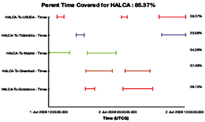
ConclusionAccording to the three simulations above, an elementary conclusion can be made that the ability of VSOP2 in the applications of geodetic research has been improved obviously. First, the average accuracy of OD is less than 0.5 m by GNSS system. It is achieved the requirement of applications for geodetic studies. Second, the proportion of tracking time of satellite by observation station is over 85%. It ensures the transmission of observing data and controling command. Finally, the observing ability of radio sources in the south sky is improved. It is just considered the improvement of VSOP2’s orbit design in this paper. The improvement of satellite structure is ignored. Considering the scarcity of data and information, we believe that more successful results can be achieved in further studying. AcknowledgementThis research is funded by the national ‘973 Project’ of China (No. 2006CB701301), and the project of university education and research of Hubei province (20053039). And most of all, this paper is to my Indian friend Prof. Madhav N.Kulkarni who, in his life time,has made tremendous contributions in the researchment on geodesy, geodynamics, and GNSS applications. ReferenceSHEN Zhiqiang. Progress in Space VLBI Science [J]. Progress In Astronomy, 1998, 6: 117-134 WAN Tongshan. The Present and Future of Space VLBI [J]. Progress In Astronomy, 1999, 6: 136-147 ISAS.VSOP-2 Proposal Abridged English Version.http://www.vsop.isas.jaxa.jp/vsop2/ NAG (1989). Precise Orbit Determination of RADIOASTRON, Report of the RADIOASTRON NAG Group to the Eighth RADIOASTRON Meeting, Greenbank, WV, May 1-5 WEI Erhu. Research on the Designment of Chinese Space VLBI System and Computation Simulation[D]. Wuhan University. 2006. YANG Ying, WANG Qi. STK in computer simulation application [M]. National defence industry press. 2002 |
||||||||||||||||||||||||||||||||||
|
||||||||||||||||||||||||||||||||||
|
||||||||||||||||||||||||||||||||||


 (No Ratings Yet)


