| GNSS | |
The benefits of future GNSS
|
||||||||||||||||||||||||||||||
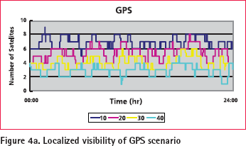
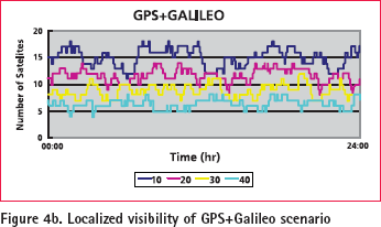
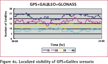
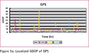
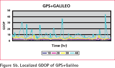
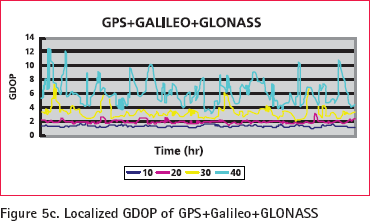
The Benefi ts of More SatellitesThe benefi ts of extra satellites have already been proved by GPS and GLONASS combined system. Galileo brings all that and more. The benefi ts of the expected extra satellites and their signals outlined above can be categorized in terms of availability, accuracy, continuity, reliability, effi ciency, and ambiguity resolution issues. Availability One of the most important benefi ts of simultaneously using GPS, Galileo, and GLONASS is the improvement in availability, especially in urban areas, as indicated in the previous section. From another point of view, the potential of GPS and Galileo to work as mutual backups is able to improve the reliability when either system is under some type of failure. Accuracy More satellites to observe means a given level of accuracy can be achieved sooner. More signals means more measurements can be processed by the receiver’s positioning algorithm. Positioning accuracy is less susceptible to the infl uence of satellite geometry. The effects of multi-path and interference/ jamming are mitigated; mean meaning the measurement quality is higher. Continuity GPS, GLONASS and Galileo being independent GNSS means major system problems, unlikely as they are, are a very remote possibility of occurring simultaneously. Reliability With extra measurements the data redundancy is increased, which helps identify any measurement outliers. The new measurements will be more independent than the current L1 and L2 measurements, because code-correlation techniques (based on knowledge of the PRN modulating range codes) will be used, rather than the ‘codeless/ cross-correlation’ techniques employed in today’s dual-frequency GPS receivers. The current L2 GPS measurements by survey-grade receivers are noisier and less continuous than those expected to be made on either of the new signals L2C or L5, hence reliable dualfrequency operation will be enhanced. More signals means that service is not as easily denied due to interference or jamming of one frequency that may prevent the making of critical pseudorange and/or carrier phase measurements. It may. However, there will be an impact on effi ciency (in terms of time to- ambiguity resolution) if not all frequencies/codes can be tracked. It should also be emphasized that newer systems, with improved electronics and antennas in the satellites and user receivers, will deliver overall improvements in data quality. Efficiency For carrier phase-based positioning, to centimeter accuracy, the extra satellite signals will signifi cantly reduce the time required to resolve ambiguities. In addition, the density of GNSS reference stations to support differential positioning using triple-frequency techniques may also be reduced signifi cantly. Ambiguity resolution The improvement in UERE will lead to an improvement in the SPS standalone accuracy and will enable a better initial receiver position to perform ambiguity resolution. Both the accuracy of the initial receiver position and the UERE will impact the estimation of fl oat ambiguities. A better estimation of fl oat ambiguities will bring more ease in the integer ambiguity fixing. Poor geometry might lead to degradation in the stand-alone positioning accuracy, given a certain magnitude of UERE. A large offset in the initial position might result in slow ambiguity fi xing or even incorrect fi xing if the position converges to an incorrect place due to the poor geometry. When both GPS and Galileo are simultaneously in operation, compared to the case of GPS only, there would be a global improvement in the constellation geometry since more than 50 satellites will be available. In this regard, there will also be a corresponding global improvement in ambiguity resolution. Ambiguity resolution directly on L1/E1 is very diffi cult since the wavelengths are so short that the measurements of L1/E1 are susceptible to ionospheric errors and other errors. However, the proper combination of the phases on the two carrier frequencies might have benefi ts of a longer wavelength and lower vulnerability to ionospheric errors or other errors, so the ambiguity may be easier to fi x than for L1/E1 ambiguities. Once three frequencies are available, more combinations among the phases of different carrier frequencies are possible. ConclusionsA technical benefi t of the geomatics and surveying industry in Taiwan is given in this article. The USA is modernizing GPS, Russia is refreshing GLONASS, and Europe is moving ahead with its own Galileo system. Extra satellites will make possible improved performance for all applications, and especially where satellite signals can be obscured, such as in urban canyons, under tree canopies or in open-cut mines. The benefi ts of the expected extra satellites and their signals outlined above can be categorized in terms of availability, accuracy, continuity, reliability, effi ciency, and ambiguity resolution issues. All the performance indices given in this article strongly indicate the benefi ts of future GNSS. AcknowledgementThis study was supported in part by research fund from the Land Survey Bureau of Taiwanese (LSB- 095-08) and National Science Council of Taiwan (NSC 95-2221-E-006 -335 -MY2). European Space Agency (ESA) is acknowledged for sharing its expertise and knowledge in Galileo simulation. References 1. K.W. Chiang, 2004, “INS/GPS Integration Using Neural Networks for Land Vehicular Navigation Applications”, Department of Geomatics Engineering, The University of Calgary, Calgary, Canada , UCGE Report 20209 |
||||||||||||||||||||||||||||||
|
||||||||||||||||||||||||||||||
|



 (No Ratings Yet)


